Monday, July 30, 2012

Helen

"...he cast the thought from him, but it returned unceasingly to his mind..." - Jules Verne - "The Blockade Runners"

All last week I was tormented by the previous weekend's failure: "This is something you can do, damnit."

So yesterday I was back at it as if I'd been born for that single purpose.

To Helen and back, or die trying.

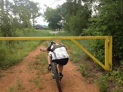
Shortly after 10 AM I left my place, grabbed some breakfast at the Racetrack and headed north out of Cumming.

 Cumming

Hwy 9 became Hopewell Road, Lumpkin Campground Road, and whatever other roads it becomes. I drew up alongside the Outlet Mall.

 The Mall

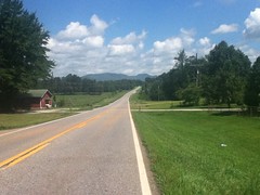
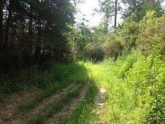
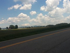
The windy, snaky roads led me back and forth across Hwy 400. I could always hear its traffic in the distance but as I wound my way north, the roar of the highway softened, and the passing cars became fewer and farther between.

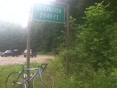
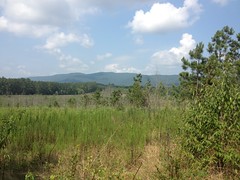
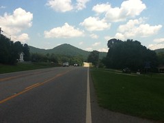
I could finally see the mountains of the Blue Ridge looming in the distance.

 Mountains Way Back There

My knees protested though: "What are you doing, Dave?"

As well, I'd forgotten to apply the Chamois Butt'r that morning. I'd gotten to where I didn't really need it much any more, but post bike-fit, I seem to need it again. I guess with my seat lower, I was kind of perpetually lifting myself off of it a bit. Now I'm solidly crunched down on it and the Butt'r feels good again.

This time, climbing Long Branch, I rememberd that it's long and uphill, and that the horse farm isn't anywhere near the top end.

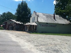
At the T'Mater corner, they were giving away free bottles of water, but I didn't need any yet.

 T'Mater Corner

I was making good time, but I wasn't feeling all that good.

This past week, I put in probably 60 or 70 miles on the road and 3 on the mountain bike. Last weekend, I'd been off the bike for two weeks or more, so I felt substantially better and stronger yesterday than the last time, but I could feel the weakness creeping in just the same. Instead of punching over the rollers with authority, I was sitting back and conserving. Hmm...

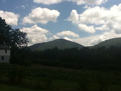
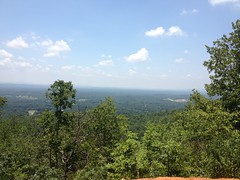
The mountains were getting closer...

 Mountains Getting Closer

...and closer.

 Long Mountain

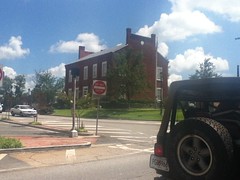
I rolled through Cleveland...

 Cleveland

...and past Mt. Yonah.

 Yonah

My neck was starting to hurt. My legs were twinging when I'd stand. I was less than 50 miles in. How is it that I rode all those miles in Florida, or the TNGA route for that matter? Yeah, it was hot yesterday, but it was hot in Florida too. It just didn't feel right.

But, at least I was making progress.

I passed the Nora Mill Granary.

 Nora Mill

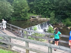
Clark and Suzy took me and the girls there once and we fed some of the biggest trout I've ever seen below the dam.

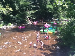
I passed Cool River Tubing where we met Tim and Lisa once for a day of luxurious relaxing and pizza.

 Cool River Tubing

I was envious of the tubers. They looked so comfortable and cool.

 Tubing the Chattahoochee

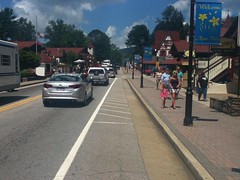
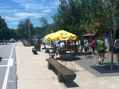
At least I was able to relax a bit too though. I'd made it to Helen.

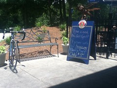
I sat down on a bench in the middle of town and called Clark. He and Suzy were about to head up to Jackrabbit. It was like 1:50 or so though, so of course, they'd already eaten, like a while ago. I should have called earlier, maybe when I'd left Cumming, or like during any of the 55 miles between there and Helen when I had nothing else to do but pedal. Why didn't it occur to me to do that? Why doesn't it occur to me to do that, in general? This is one of life's great mysteries. That's the kind of friend I am folks, at least, at present. Damn.

I was starving and I needed lunch, so I headed south to the Nacoochee Tavern. There are other places to eat in Helen, but on the bike, that seems like the most convenient because you can park your bike behind a bench, sit outside and keep an eye on it.

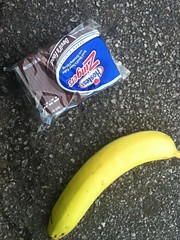
The chicken parmesan was bulky and generous.

 Nacoochee Tavern

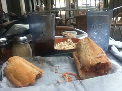
It's a foot long, and that's a "half" sandwich. The "whole" sandwich must just be two sandwiches. They couldn't possibly fit a sandwich twice that size on any plate.

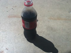
I had a glass of ice water and a glass of Pepsi. The water kept giving me brain freezes but for some reason the Pepsi didn't.

The guy and his family at the next table were driving back from North Carolina and he asked me a dozen or more questions about road vs. mountain bikes and about how tough of a time I'd had it with some of the grades up that way. I got the impression that they were thinking about getting into it themselves and were trying to figure out what to buy. I hope they figure it out. It'd be great to run into them on the road or on the trail one day.

The sandwich was beyond delicious but it sat heavily in my stomach when I got going again. Dead legs and a ton of lead. This was no problem though, I know that feeling well, and around Cleveland I started feeling a little better. I was burning water though. It was as if water was a thing that could be burned. I downed 40 oz in 20 miles.

Pulling into Dahlonega, I was a wreck. My neck and back were killing me. My legs were still twinging whenever I'd stand. My right arm was burning like I needed more sunscreen, and the energy from the sandwich was just barely starting to hit me.

Back at the restaurant, some weird bug kept landing on my arm and eating the delicious salt crystals off of me. I'd shoed it away at first but eventually I became fascinated and examined it closely enough to watch it eat the individual crystals. Though I knew not why at the time, the image of that little bug eating that salt had invaded my mind and nagged me persistently. The rusty gears of my subconscious had apparently been turning too, and as I approached the Shell station in Dahlonega, it occurred to me... Electrolytes. Big time.

 Magic Gatorade

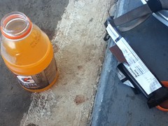
When you're really thirsty, Gatorade tastes really good.

The guy behind the counter seemed concerned for my safety in the heat. I don't know how hot it was, but he was from India, and no matter how hot it was, it doesn't compare to the heat in India, and I've seen videos of kids running around playing soccer in the dead middle of summer there, so I'm not sure why he was so worried. It was definitely a kind gesture though.

About a mile later I felt like a new man. No twinging legs. My back and neck still hurt but that was going away too. I drank another 40 oz over the next 15 miles and had to stop again in Matt. More gatorade. This time I just filled one bottle with water, the other with Gatorade, drank the rest and hit the road. By the time I got back into town, I felt like I hadn't ridden more than 20 miles.

Rolling into my neighborhood, I powered over the step-ups like they weren't even there and ended the ride feeling the strongest I'd felt all day.

Ok, so, when I race, I always drink well and eat well, but that can get expensive, so when I'm just out riding or "training" I tend to drink water and eat whatever garbage I can scrounge up at the gas station. This is more than sufficient for short road rides and medium-length mountain bike rides, and it's good to run yourself short on one resource or another on a longer ride from time-to-time so you know how your body will react to such shortages, but I guess what I realized today is that if I'd fueled myself properly from the beginning, I'd not only have enjoyed the ride more but I'd have been able to work myself that much harder as well. I need to re-evaluate my non-race nutrition strategy and come up with a better balance. It's important to know how to manage suffering effectively, but it's also important to not always suffer. Or something like that. I don't know yet.

At any rate, yay, I made it home and Kathryn didn't have to pick me up. And I didn't give into the temptation to go try to climb Unicoi Gap, though perhaps just because I haven't watched any cycling on TV for a week. Either way, it all worked out and the nagging thought of having to do it over again has finally been cast from my mind.

Thursday, July 26, 2012

Haw Creek

I can't remember exactly when it was, but a while back somebody posted on either Facebook or the Sorba forum about a new park off Echols Road in Cumming and the guy from Sorba Rambo said something like "Oh yeah, we're working with Forsyth Parks and Rec to get a beginner-level trail built there." Something like that.

Echols Road is like 2 miles from my house, so you can imagine that I'd be excited about this new development, independent of how many miles of trail are going in, or how difficult they are.

A month and a half ago I saw them start work on the parking lot. A few weeks back I noticed a trail head on Samples Road. A week or so ago I read a headline that the park was open. My older daughter's friend Madison mentioned that her brother has been riding his bike there already. It was time to give it a spin myself.

A few days ago I spun a lap of the park on my road bike to get some GPS data, which is already up on my trails site, and then yesterday I took the Iz over to see how she how she could shred.

.  The Iz

And shred she did. On fire road...

 Haw Creek Fire Road

On singletrack...

 Haw Creek Shred

And on everything in between.

She did not, however, shred two sections of the trail. This one...

 Haw Creek Gnar

...which, riding into it, appeared to her to be just a big pile of rock instead of a trail. And also, there's a short little drop across a ravine that didn't look rideable to her either. Other than that though, she cleaned the trail.

Ideal!

My kids are small. Me and Kathryn are small and we made even smaller kids. Iz is 12 but most 9 year olds are taller than her. Sophie's 9 but she's as tall as the average 7 year old. As such, they struggle with technical trail features. They can ride 20 miles of greenway, no problem, and of course, Mosquito Flats but that's about it. The innumerable roots of Mt. Adams are even a bit much for them. It's difficult for them to get in a satisfying ride on dirt. Blankets is fun, but driving all the way over to ride a bunch of 1 mile flat laps just doesn't do it for them any more. They'd love Chehaw (in Albany) and Santos (in Florida) but that's how far we'd need to drive to find something long and fun that they could handle. There just hasn't been that next-step trail until now.

The Haw Creek trail is exactly what I've been looking for. It's about 3 miles long and twisty, but also wide and non-technical and with enough climbing to challenge a kid without breaking them off halfway around. Given its location, in the middle of 3 neighborhoods, right next to two elementary schools and a middle school, it's the perfect trail for the setting.

I also like that it's road-bike friendly enough that I can use it to get between Samples and Echols Road on my way to James Burgess.

This is a fairly representative shot of the trail.

 Haw Creek Singletrack

Wide, twisty, shallow grade, but not flat.

Awesome.

And it's nice that the property itself got some attention too. Word on the street was that squatters were occupying an old, crumbling house up near the front of the property and towards the back... cockfights. I've got a little of that duality re. squatters. Having squatters for neighbors can be bad for your property value, but you know, folks might just be down on their luck and the squatting itself may not present a problem, per-se. Cockfights though... What the heck?! I didn't even know people did that any more.

No chance of either now though. If there were homes or other structures on the property, I think I know what happened to them:

 The Great Rubble of Haw Creek

I also heard that at the grand opening, most of the neighbors were all "Yay!" but at least one of them wrote letters about how pissed she was that there weren't ball fields and playgrounds.

Given the hydrology of the area, I can only imagine how expensive ball fields would be to build. There are 3 playgrounds though, with stuff to climb on and over:

 Haw Creek Playground

There just aren't monkey bars and swings. Who knows, maybe next year there will be. I'm pretty happy with the park.

Me and Iz spun one lap. She could handle the trail but the elevation was a new challenge for her. Ha! Yeah, use those gears kid.

Next time, we're riding three laps. Maybe we'll bring Sophie along too.

Monday, July 23, 2012

Unicoi Gap

Abnormal is the new normal.

I think that's just how it's going to be for a while. Maybe for a long while. "Nothing endures but change."

Something like that.

Case in point... I haven't seen the road or the woods in a couple of weeks, except on TV.

Of course, I've been watching the Tour, so today, when I did get a chance to ride again, I felt like putting in a million miles on the road. I've long wanted to ride from my house to Helen and back and today seemed like the right day to try it.

I tried to get up at 6 but it just didn't work. 8 turned out to be more my speed but it took forever to get out of the house. I probably rolled out at 9. It was damp and cool outside and my driveway was slippery. I'd soaked myself in sunscreen but it seemed foolish at the time. There wasn't a sliver of sunlight visible in any direction until I got out of the neighborhood.

I've been known to do The Zero but today's ride seemed like it might demand a few calories.

 Breakfast

I wound my way north, back and forth across Highway 400, past some awesome old houses...

 Old House

...past an old cemetery with gnarly, bent, and broken old tombs.

 Tombs

Past the Chestatee.

 Chestatee

I've driven from Dahlonega to the Jean Anderson intersection (where you hang a right toward Helen) a hundred times, maybe more, but for some reason it seemed to go on about 10 times further than I expected today. The horse farm where they give the trail rides always seemes like it's most of the way to the intersection but it's actually much closer to Dahlonega than that. I guess I'll have to keep that in mind.

Also, the road is called Long Branch Road, and with the Chestatee at the south end, I guess I should have realized that the road runs up the Long Branch valley to whatever unnamed gap lies up that way. This never occurred to me driving it, but it was immediately obvious on the bike.

Immediately.

For whatever reason, the next leg after that seemed about as long as I expected.

My stomach was getting empty again for some reason so I stopped at a gas station for more calories.

 Lunch

I had an ice cream sandwich too and it was really good.

Closer to Cleveland I caught my first glimpse of the mountains over a massive field of corn.

 First Glimpse of the Mountains

Traffic on the highway was remarkably light for some reason.

My legs still felt sleepy. Usually if I've bene off the bike for a while, it takes a good 30 miles to warm up. Maybe it would take longer today.

The mountains drew ever closer.

 Slightly Closer

Where were my legs?

The road bent left and ran along the west flank of Long Mountain. At the north end lay the little town of Cleveland - gateway to the mountains.

 Cleveland

I guess it goes without saying that the sun was finally out in full force at this point. It wasn't Texas-hot but it was definitely getting warm.

Pressing further north, I passed Mount Yonah...

 Yonah

...and made my way into Helen.

 Helen

Helen is always packed. Driving in can take a half hour from the edge of town to the center. I passed a hundred cars or more on the shoulder.

I was actually stunned when I discovered that it's legal to pass cars on bike. A guy in an orange Camaro seemed pretty well stunned himself and pulled over on me until his front right tire was off the road on the grass. "You shall not pass!" All I could do was shrug my shoulders at him, which appeared to be what he was looking for, and he let me by. It was weird.

I'd long wanted to ride to Helen and back, but my head was full of Tour-inspired bad ideas and I felt a little ambitious.

On to Unicoi Gap!

I should have realized how bad of an idea this was because my legs still felt weak and my breathing was garbage, but hey, I was way up there already. Might as well, right?

No.

I imagined myself Thomas Voeckler, confidently charging over the Pyrenees, but in reality I crawled up the mountain, drawing dissatisfied looks from the roadies descending in the other direction.

Ohhh, it was a crawl, but I made it.

 Unicoi Gap

Then I sat down on the steps of the AT for a while.

An older gentleman and his wife were looking for Horsetrough Falls. I pointed them in the right direction.

It was hot. It was hot in the shade. I hadn't been drinking enough I guess.

I downed most of what I had and headed back toward Helen. You'd think that I'd have gotten some recovery on the descent, being downhill and all, but if you've descended off of Unicoi before then you know that's just crazy-talk.

My plan all along had been to get some lunch in Helen, so I stopped at the Nacoochee Grill and called Clark to see if he and Suzy wanted to meet me for a bite. Or, at least, I tried to. I had my wife's phone and I'm not sure the number it it for them was right - the voice mail message didn't sound like what I remember. Dangit.

 Nacoochee Tavern

It was Two-something. We needed to be in Douglasville by 5 or 6 to pick up my kids from my mom's place. I could either eat, rest and ride home or call my wife to pick me up. It would take an hour to eat and rest. The ride back would take 3 or 4 hours, assuming I didn't bonk or worse. I'd been too ambitious.

I'd only called my wife to save me once before, and she wasn't too upset when I called again. I ate a really good chicken parmesan sandwich and sat in the shade while she drove over to pick me up.

And that's how it ended today.

Next time?

I'd like to try again. Will I? I hope. We'll have to see what the future holds.

Sunday, July 8, 2012

Anniston

In the late '90's before I even moved to Georgia, I'd heard tales of a trail in Anniston Alabama. Iron Legs they called it, and having just recently begun to ride, the name struck such fear in my heart that even though I made several road trips to Oak Mountain and Tsali, and passed directly through Anniston, I dared not attempt the loop.

Since then, my mountain biking has improved slighty, but it never seemed worth it to make the trip to Anniston to just ride that one loop. With the recent opening of the Coldwater Mountain trail though, and the subsequent, widespread approval from the general mountain bike community, Tim suggested that we head over there for a Tour de Anniston of sorts and that sounded like a great idea. Apparently there are other trails in the area too. Who knew? Actually, you'd think I'd have known, seeing as that's kind of my thing, but in this instance, nope.

Saturday the Frere called, wanting to ride at Bull. I countered with the Anniston idea. He lives like 45 minutes from Anniston and before I was even done with the proposal, he was in. Maybe we could all go. I tried to get a hold of Tim, but I'd apparently lost his number in the Great Drenchening a few weeks back. Facebook came through for me but he was already headed to the beach. Dangit! I guess if you're going to miss out on a ride, a beach trip with the family is a pretty good reason.

I met John at the Douglasville Park and Ride and we headed west immediately. It was a little tricky to find the Iron Legs Lot though. It's not a parking lot, per se, but just an anonymous turn out off of the road.

Back up the road there was a more likely looking lot, but it turned out not to be the correct one. That lot had a very interesting feature though, a single grave site, perched on a hump of ground, bordered by the road to the south and encircled by the turn-out.

 Woodrow Smith Grave

3 years old. Terribly tragic. Now I want to know the story. Somebody knows, I'm sure. I bet if I went to a nearby gas station the clerk would know. I need to start doing that for these kinds of things.

When we finally found the lot, we hit the trail. It was a sandy fire road at first but it narrowed down by degrees and eventually became glorious singletrack.

Glorious!

Whoever built that trail knew what they were doing too, even if they didn't know that they knew what they were doing. It was especially amazing, given how long the trail's been around. The trail followed the contour, it had grade reversals, here and there it ran up or down the fall line, but only where the soil was extremely rocky and durable. It was smooth and flowy and rough and technical and there were switchbacks and runouts and man! This is what I'm talking about! The trail was IMBA'ish but it was still very technical because someone found technical terrain and ran a trail through it. They didn't just rely on massive erosion to create technical features for them. We need more of this. Ironic that this ancient, pre-IMBA trail is a decent example of it.

I really dug Iron Legs. The only complaint that I have is that I was able to ride all of it in my middle ring except one really loose section where they'd recently cut a fire-break coincident with the trail. I'd hoped to have truely needed legs of iron.

Actually the only other complaint that I have is that it wasn't longer. I think the loop was around 6 miles, and it's a long drive for a 6-mile ride.

It's rare that I get an opportunity to take photos when I'm riding with John. Either I'm chasing him down or he's right on my back wheel, and we're rarely creeping along at photo-op speeds. There was one really cool point of interest though, that I had to stop for.

 Fuselage From Side

I don't know if that's an old fuselage or just a mock-fuselage, but either way it was wild. I rode through it.

The whole are was once part of Fort McClellan, and there's allegedly an old mock Vietnamese Village out there somewhere too. We didn't see that, but apparently there's a rock garden in the area too, so we could have ridden right through it without raising our eyes from the trail.

The last little bit of singletrack appears to have been totally abandoned, I'm surprised we were even able to find it, actually, and where it once led across a field, it's totally overgrown so we had to field-whack a little there. When we were done, we ended up back at the grave site and took the road a block and a half west to the car.

Having recently gotten my bikes fit, I had been really unsure of myself for the first few miles, as this was my first mountain bike ride since. I felt way more powerful climbing but the geometry was different and it just felt strange. I had a little trouble twisting around but only because my instincts needed to be retuned. For the middle couple of miles I had to think about what I was doing, but for the last few, everything seemed natural again. There was only one little downed tree though, so I was still unsure how well I'd be able to get the front end up.

Next up, Morgan Mountain. The trailhead was just up the road and a little less anonymous than the Iron Legs lot.

 Morgan Mountain Lot

The most interesting feature of the Morgan Mountain Lot was the goose carcass that we passed on the way in.

 Goose Carcass

Zoom in on the beak and notice the weird tooth-looking structures there. Weird. It reminded me of those Archaeopteryx skeletons with the teeth. I wonder if they had beaks too, that just deteriorated away and left the skull and teeth behind. These are the kinds of things I think about, for some reason.

We started out on Marks Loop, which wound around through the woods a bit before busting out into what I guess is what's left over from a clear cutting timber operation. The view was pretty nice from there.

 View From Mark's Loop

Then it wound around some more, crossed a road and disappeared entirely. The map showed it sidehilling up and around the mountain, but no discernible trace of the trail remained. Dense weeds obscured it completely. Maybe if I was really, really familiar with the route, I'd have been able to follow it, but after trying for a few minutes, we gave up, took a logging road back to the main road and took that back to the lot.

We rode the rest of Mark's loop backwards from there. That section was apparently once an asphalt road. Here and there, short stretches of it poked up through the pine needles and the root mat. I've seen plenty of trails on old, overgrown dirt and gravel roads but an old, overgrown asphalt road was a new one for me.

The other chunk of the trail teed into that logging road we'd been on before. Not sure how we missed that intersection, but we did.

We tried riding the "Family Trail", but it too had been obliterated.

We basically ended up riding various loops out to that logging road and taking the main road back, three different times. There was a gate at the end of the logging road and we got reasonably good at limboing under it.

 Limbo

Man! That sucked, and it looked so promising on the map. Maybe Gene's Loop would be better.

 Gene's Loop

Hmmm. No such luck. It had met a similar fate - clearcut logging had completely removed a huge chunk of the trail. In the distance I could see the mountain that it must wind up and around, but getting to it was impossible.

We tried hard to ride Gene's Loop but there just wasn't enough of it left to do very much. I did manage to hop a half dozen downed trees though, of every conceivable size and orientation. Apparently, even with the new fit, it's not that difficult.

Next.

Coldwater Mountain!

Ok, this trail had to exist because it opened just a few weeks ago.

And boy did it exist.

The parking lot was a bit less anonymous than Morgan Mountain. There were no bathrooms or water but it had gravel to park on and a kiosk with a map.

 Coldwater Mountain Lot

The trail was amazing.

The first mile or so was all rolly-flowy with dozens upon dozens of little jumps - singles, shallow doubles and tabletops.

Then there was about a 3 mile climb with long runs and several groups of switchbacks and rock gardens and stretches of just rocky, chunky trail. At the end of the climb, it joined an old, semi-rutted fire road for about 100 yards before finally peaking out.

For the next half mile or so it twisted downhill alternating between smooth flow and brief rock gardens, then the jumps started again. There must have been hundreds. Hundreds! Waaaaaaaa! They seemed to be in 3's or 4's, but that might just have been how my brain processed them. Jump, jump, jump! A lot of them looked like if you got enough speed to double the first one, then you'd float over the next two. It was tough to commit though. I wasn't familiar with the trail and doubles always make me nervous. Eventually I started manualling them, then I hit a couple of small ones, but I never got the courage to float the longer ones. John did though. We alternated who led and he pulled away from me easily. Damn. I need to ride there more often.

There was even a great view at the top of one of the berms, and a long line of sight so you could easily see people stopped there.

 View From Mountain

Awesome.

I didn't even notice the new fit on any of the jumps. I was worried riding into the initial descent that the seat height would be a problem but like half a mile it felt natural and eventually I just forgot about it.

After the long descent, there was a half mile or so of climbing, another long descent and then the climb back out. At least, that's how I remember it.

As we began the climb back out, we passed a lady, taking a break. A half mile or so later a kid came riding toward us, half frantic: "I'm sorry! I'm sorry! I'm sorry!..." The trail is directional and he was riding backwards, thus the apologies, but his tone of voice was disconcerting.

John: "You ok man?"

Kid: "No, I've lost my mom!"

John: "Does she have a black bike?"

Kid: "Yes."

Me: "Does she have a frog tattoo on her calf?"

Kid: "Yes!"

His mom was the lady we'd passed. She was 10 minutes back or less, and she seemed ok when we passed her. The kid was out of water though. I gave him my bottle. It was only half full, but it was all I had.

That's how hot it was, by the way. I drank a bottle and a half in 8 and a half miles.

John suggested he rest in the shade and wait for her. She would be along soon.

Turned out his dad was back at the lot and we told him what was up too.

I wanted data for the short little beginner loop so I tanked up my other bottle and spun that loop. The kid's dad was walking toward me as I neared the lot. Uh oh. They hadn't returned. Maybe they'd had a mechanical. Maybe they'd run out of water again. Hmmm...

I headed back in their direction. My heart sunk when I passed the spot that we'd left the kid earlier. I finally found them another quarter mile down the trail. He'd gone after his mom, they were now both out of water and had begun walking back to the lot.

Ok, never mind what I said earlier. The mom had drained a 60 oz camelback in 8 miles. THAT is how hot it was.

I gave them my other bottle. I met the dad again on the way up again and a buddy of theirs was a hundred yards behind him, jogging two Powerades down. I thought of offering to take them down for him but I saw his "Tri-State Adventure Race Team" shirt (or something like that), and I figured: "He's got this."

And so it was, no crisis materialized. The whole family arrived back at the lot eventually and the adventure racer emerged from woods after having freehand nav'ed himself back to the lot. I got my bottles back. All was well.

Me and John grabbed some Zaxby's in town and eventually made our ways back to our respective homes.

Oh, man, Anniston is great. It's too bad I didn't get to ride Morgan Mountain and Gene's Loop when they existed but there are apparently even more trails out there, so I'm going to have to go back sometime soon. Maybe me and Tim can go next time and he can show me around for real.

Wednesday, July 4, 2012

Buford Hatchery and Sea Creek Falls

It's the Fourth of July! Happy Birthday USA!

There were a dozen or more 4th of July rides today, including one with the Reality Team, who, despite being on it, I have yet to actually ride with. I rode none of them though because until about 10:30 last night, I didn't think Kathryn would be back in town until the day after tomorrow, at least.

As fate would have it though, she showed up in the ATL right around midnight. Woohoo! Still though, I didn't have enough time to commit to a ride. I need to swap my front brake pads and possibly bleed the brake. Plus, it wouldn't be cool to hit her with watching the kids all day on the 4th, especially when she just got back in town.

Instead, we slept in and did some family stuff.

Family stuff number 1: fishing at our favorite little pond.

 Fishing

I think it was 105 degrees though, so we didn't catch much.

Family stuff number 2: play in a waterfall.

Sea Creek Falls, to be precise.

The drive up on Highway 60 gave Kathryn horrible car sickness. It's pretty twisty up through there.

Sophie and I climbed all over the falls.

 Me and Sophie on Sea Creek Falls

Here she is doing her spider-girl impression.

 Spidergirl

And here she is, building up the courage to get into the freezing cold water.

"Ok, Ok, Ok... Here I go... Ok...

 Ok, Ok, Here I go.

And finally she got in, up to her knees, but that was all.

 It's Cold!

Kathryn climbed up to take some photos but otherwise, she and Iz mainly just sat on a old tree trunk with their feet in the water.

 Iz and Kathryn

I've long wondered how deep it is right under the falls. There's this big overhanging rock and the falls kind of slides in underneath it.

 Exploring Below the Falls

Turns out it's deeper than I am tall. I couldn't reach the bottom and it was too narrow to safely try to find the bottom without a rope to pull myself back out with. Yaaah.

Eventually, Sophie got used to the water temperature. It was actually really nice, as long as enough of your body was above the water. It wasn't 105 anymore, probably more like 85, but it still felt good.

 Sophie

I have no idea what we were doing here. My tan is coming along nicely though, eh?

 Sophie and I, no idea...

Kathryn took a couple of artistic photos, including this one of wet footprints.

 Footprints

The last time I was there, I noticed this big rock-chunk thing that I assumed was a bridge footing, toppled over on the shore.

 Sea Creek Falls - Bridge or Dam Footing

There's another one nearby too.

 Sea Creek Falls - Bridge or Dam Footing 2

Neither appear to still be in their original orientation though and the second looks like it might have been broken into chunks.

I originally assumed that the trail that leads to the falls was once a road and that it crossed the creek via a bridge right there, below the falls. But looking at it now, that seems somewhat unlikely. It's really shallow there. The road may have crossed, but it would more likely just have been a ford. So what are these big chunks mortared-together rock? Were they part of some downstream bridge that was torn down and dumped there? Were they the remnants of an old dam? It looks like there might have been houses or a farm or something along the trail on the way in. Maybe there was a mill. I could easily imagine a dam there at the base of the falls. It wouldn't have been too much work to hem the entire falls in, given how rocky it is to either side. Hmmmm....

The last time we were there, the old tree trunk that Kathryn and Iz were sitting on had big limbs dangling off of it but somebody has gone in with a chainsaw and hacked them off. It's a lot easier to sit on the old trunk now. I guess that's why they did it.

There was a bit of new civil engineering up there too.

 Sea Creek Falls - Small Dam

Somebody's built a little dam across the creek. Did the Forest Service do this? The purpose wasn't immediately clear but I don't know too much about such things. It hems the creek in pretty well, making it flow out entirely on the west side. There's not much of a pool behind it though, and it's so short that I can imagine it'll get washed away with any serious volume of rain. Or at least, the sand packed in on top will. Maybe it marks the route of the original dam, if there was one. Maybe the intent is for it to get backfilled so the woods will spread down into the current creekbed. I'm not sure why you'd want that though. I dunno. It was odd. I'll have to ask around.

We took some dirt roads home, up over Cooper Gap. It's a lot steeper and rougher, but it was a lot easier on Kathryn's stomach than Hwy 60.

We'd planned on going home and grilling afterwards but Kathryn was starving and it was getting pretty late so we just hit the Ruby Tuesday's in Dawsonville. In case you were wondering, white cheddar mashed potatoes are good. So are their biscuits.

All right. We had ourselves a minor adventure. I've been really short on those lately. Hopefully it'll be the beginning of a trend.