Monday, June 29, 2015

Chattahoochee River Trail

My hikes just keep getting better and better. These last three have been some of the most fun and interesting I've had in a long time.

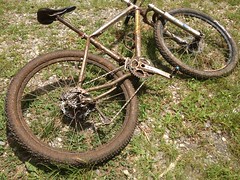
This past weekend started off promising. John, Howie and I had plans to put in some solid miles on the road bikes on Saturday. I managed to get a hold of Clark on Thursday too, and he thought he might be available to do some exploring on Sunday. All-around, the weekend was looking busy and fun.

But, as they sometimes do, work and weather conspired against me. I spent all day Friday solving an obscure problem for one client, which meant that I didn't spend all Friday putting together a demo for another client. Combine that with an 80% chance of rain on Saturday... We punted on the bike ride and I spent the whole day on a coding binge. Then, it turned out Clark had work to do on Sunday as well, so he was out too.

Dangit!

Well, Sunday morning rolled around, and I headed north anyway. Good thing I enjoy exploring by myself. It seemed I would be enjoying it again.

Last weekend I discovered the Chattahoochee River Trail. I.e. the railbed that the Byrd-Matthews Lumber Company ran up into what is now the Chattahoochee WMA to log it into oblivion. I'd discovered it at the end of the day though, and really only got to hike a mile or so. This time though, I had all day, and I was even getting an earlier start than usual.

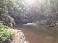
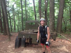
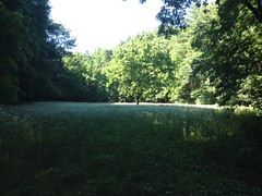
Conditions were ideal. I got on the trail around noon. It was sunny. It was cool. It had rained a little the day before, but hadn't poured. The river wasn't too high. Ideal.

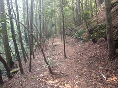
The trail was just right.
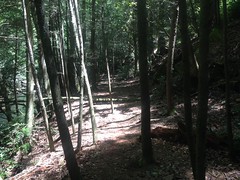
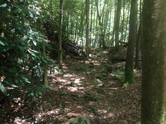
Chattahoochee River Trail 1 Chattahoochee River Trail 2 Chattahoochee River Trail 3

Beautiful!

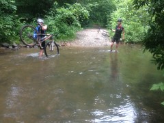
I quickly passed where I'd had to turn back last time, and crossed the river over and over.
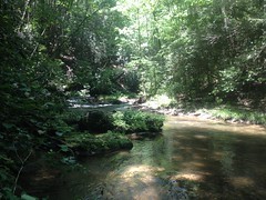
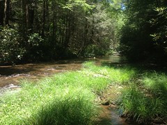
Chattahoochee River Crossing 1 Chattahoochee River Crossing 2 Chattahoochee River Crossing 3

Also beautiful.

None of the crossings were too difficult. I don't want to get cocky, but I seemed to have knocked most of the rust off of my "is that safe to step on?", "over or under?", and "hands-and-feet" skills. The only slip I had was, ironically, dropping down to the trail from the parking lot. It looked dry, but it had rained, and there was a thin slip layer... Grrr.

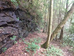
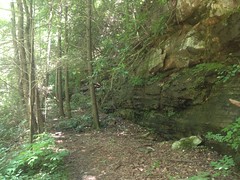
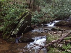
The old railbed was easy to follow, for the most part. When it appeared to end, there was always more on the other side of the river. It did seem that the designers' objective was for the rail to be on the opposite side when a creek would tee in. Why though? Was it easier to build a trestle across the river than across a feeder creek? Did it make loading logs easier, somehow? Man, I want to know. Somebody knows!

There was an exception to this general rule though. At some unnamed creek north of Turkeypen Creek, at a bend in the river, the old railbed didn't cross over, but then also just seemed to disappear. You could see where people kept going from there, but there was no obvious sign of the old rail.

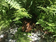
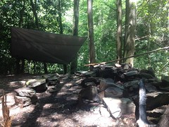
I spent about 20 minutes looking around and found all kinds of weird stuff. There was a campsite where somebody had built a shelter some time ago.

Collapsed Shelter

It wasn't unlike the one me and Clark found up on Henson Branch, or at least it wasn't before it collapsed. Maybe the same guy built it.

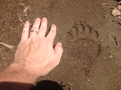
There were beavers in the area too. I guess?

Beaver Maul

They didn't seem too determined though. Nearly every tree in the area had been mauled, but none appeared to have been actually cut down. There was no sign of a dam either. At earlier campsites, there were clear signs of the activity of "human beavers", where people cut down small trees for firewood and scraped bark for tinder. People seem do that at waist-to-shoulder level though,and actual beavers do it way down at the bottom. All the scrapes around there were really low.

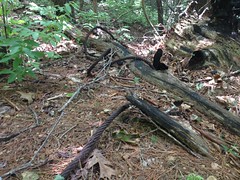
There were also these weird iron things.

One was all ornamental.

Ornamental Iron Thing

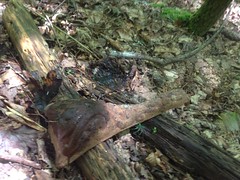
The other looked like part of a stove or something.

Broken Iron Thing

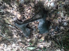
Whatever it was, it looked like it had been blown apart from the inside.

Maybe both were parts of an old locomotive. Maybe they were just dumped there. Maybe one day I'll walk into a flea market and see something that sheds light on the mystery. Until then... No idea.

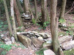
I did, eventually find the old rail bed again, a hundred yards or more from where it had disappeared earlier. There must have been an impressive trestle there back in the day.

The trail seemed less traveled from that point on, but it was still passable, and I made a few more interesting finds.

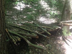
If there's any question as to whether the trail is an old railbed, this artifact ought to lay it to rest.

Old Byrd-Matthews Rail

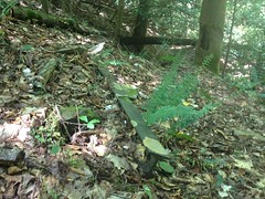
It was just lying there. No idea why it wasn't taken out with the rest of them, but it wasn't. I've seen the same thing on the Silver Comet trail. A few old rails, just lying off to the side. Things get left behind sometimes. Whenever I see that, I always wonder about it. Why that one thing? Was it just an oversight? Did they run out of time? Was alcohol involved? That last one is always my favorite theory. I suspect it's more often the case than it might seem.

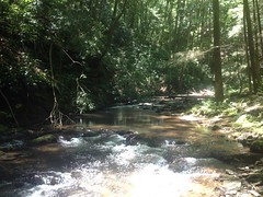
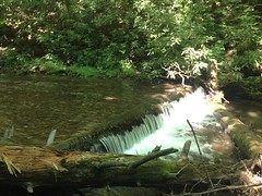
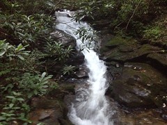
The trail crossed the river there, and there was a small falls that required a little negotiation. It wasn't immediately obvious where the trail picked up either. Again, I spent about 10 minutes looking, and followed a few false leads, until I finally saw this:

Stacked Stone Fill

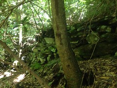
Definitely man made. I recognized it from similar fills along the Raven Cliffs Falls Trail, which is also an old railbed.

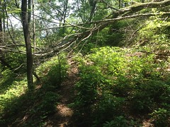
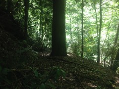
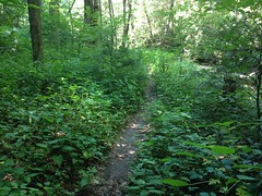
Yep, the trail was right there, but it was also quite overgrown. Not impassible, but I had to push stuff out of the way pretty regularly.

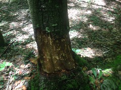
I came upon a tree that I liked too.

Defiant Hemlock

The Defiant Hemlock. That tree is all "I'm going to grow right here. Right here. Right, dead in the middle of your logging road. Yeah, cut me down and haul me out. Ooooh, wait. You can't. Not for like 90 years now. Ha!"

At least, that's what I imagined it would say, if it could speak. Or think. Or perceive anything.

Personification!

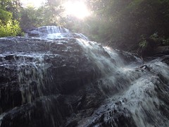
There was a larger falls further north, and the scramble down to it was really, really sketchy.

Chattahoochee River Falls

It was easier climbing out though. It would seem that my "is that safe to step on?" and "hand-and-feet" skills are good, but my "should I face forwards or backwards?" needs a little work.

The trail in the immediate vicinity of the falls was fairly clear and fairly well traveled. There was a 5-star campsite immediately across the river too, with what appeared to be a well-worn trail leading up away from it.

Luxury Campsite

Got it. People camp there, see the falls while they're at it, but don't often go any further up or down stream.

I did though, upstream. Another stacked stone fill indicated where to go.

Another Stacked Stone Fill

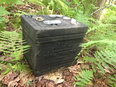
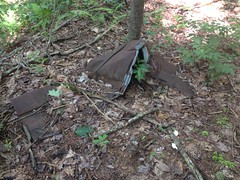
Before long I recognized where I was. I'd been there a few weeks ago. It was an old campsite with a weird bulk-chunk-iron grill thing in it. I hadn't seen the railbed at the time, but I didn't know to look for it either. Turned out it wasn't hard to find, but you know what else I found? An actual grill.

Grills

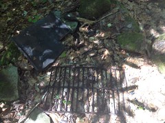
It looked like someone had just chucked it off into the woods. I chucked it back into the campfire ring. Maybe it'll be useful to someone. Might do a better job than that weird block-chunk.

About that time I realized that I needed to eat. I'd been carrying around a Big 100 bar in my pack for like 3 weeks and I figured I'd better eat that.

Lunch

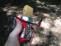
Hmmm... They're not very good. Not bad, just not "Mmmm... wish I had more of that" good

At first I tried to eat and walk. But, that section of trail bordered on impassible. It kept knocking my hat off, and a stick jabbed me just below the eye. Arrhhh. Ok. Eat now. Walk after.

After 50 yards, if I hadn't known that the trail must be there, then it would never have occurred to me that it was. The words "overgrown" and "reclaimed" really don't say it. Fortunately there were no thorns. Also, fortunately, it was short, and one river crossing later, it was back to being well traveled.

Chattahoochee River Trail 4

Turned out I was really close to the Upper Chattahoochee Campground.

Old Pool on the Chattahoochee

The road there appeared to have been built on top of the old railbed. In fact, that appeared to be the case all the way up through the campground.

Horsetrough Falls is up that way, so I took a quick trip out to it.

IMG_1890

I couldn't find any clear evidence that the rail had continued past the campground. It would make sense for that area to be the end of the line, actually. The mountains get pretty steep north of there. Logs might have been skidded down to that spot, loaded up and taken out on the rail. There might have been a logging camp there at some point too. Seems like Clark mentioned something about that a while back... Could be why there's a campground there now.

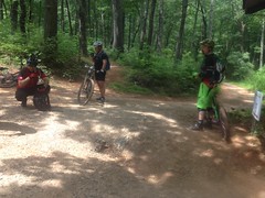
At any rate, I explored the various side trails too.

Somebody had created some art along one of them.
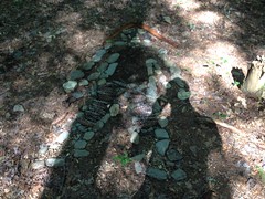
IMG_1891

It's art.

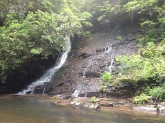
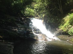
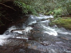
Another led up along the Chattahoochee even further, past a fairly spectacular falls.

Upper Chattahoochee River Falls

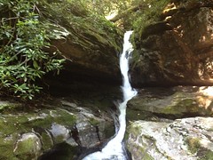
That's the entire Chattahoochee, flowing through that crack in the rocks.

It's much bigger than it looks in the photo. I could easily stand under that ledge on the left. My camelback is actually sitting on the rocks under the ledge, but it's difficult to see.

That trail was cleaner than anything I'd hiked yet that day. It lead to Crain Field, which Clark, Suzy and I'd been to before, riding up FS44E.

Food Plot on FS44E

The last time I was there, I hadn't noticed the trail continuing north. There it was though, and it kept going and going. As much as I wanted to keep following it, there were two issues. First, it was getting late. Not late in the absolute sense, but late in that I needed to start getting back, or it would be very late when I did. Second, there was a campsite back there, a couple had just arrived not 10 minutes before I did, and I didn't want to be all up in their space.

It's funny, I saw very few people, all day. There were like 5 fishermen at the very start of the trail. Then, I saw the Sheriff, of all people, pull into and then back out of the campground, patrolling, I guess. And, then these folks, in the most remote spot I'd yet been. What are the odds?

Good enough though. Now, I know where I'm going next weekend.

On the way back, I took the road over to Vandiver Branch and took the falls trail down along side the creek. Turns out it teed in where it had appeared to earlier. Good to know. Also, several spots looked like they'd been taken out by landslides. If I hadn't been pretty sure it kept going, I might have declared it to have ended earlier than it did.

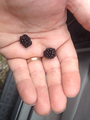
Figuring it'd be quicker than backtracking and taking the road the long way around, I bushwhacked up the ridge to the food plot at the top of the knob there. If you ever get the urge to do that... I mean, that specific ridge... Reconsider. There are these vast, dense, horrific thickets on that ridge. You can't get around them, and only two things grow in them: locust and blackberries. That's all. Both have thorns. It was horrible.

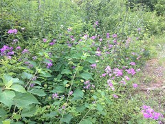
I got where I wanted to go though, and probably saved some small amount of time.

Back on the road, there were lots of flowers growing along the edge and bees were attacking the heck out of them.

Some Purple Flowers

My eye started to sting where that stick had gotten me. I wanted to look at it, but I didn't have a mirror. I keep meaning to get a mirror, but then I keep forgetting too. Fortunately I did have a technology-mirror.

Technology-mirror, show me my face!

Rhododendron to the Eye

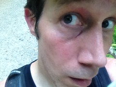
Hmm... Well, at least it wasn't bleeding.

Earlier, it looked like there might be a trail leading up Jasus Creek, from the Chattahoochee, so rather than take the road all the way back down, I checked it out. Yep, there was a trail, leading downstream. It crossed several times, and a few times I just had to walk down the creek itself, but the trail eventually picked back up, every time.

It looked, at first, like I'd have to get over this falls somehow, but then the trail picked up again within feet of the edge.

Lower Jasus Creek 1 Lower Jasus Creek Falls

If you don't mind getting your feet wet or "hiking" on "trails" (note quotes around each), it's really nice back in there.

Lower Jasus Creek 2

Oh, man I was running out of time. I had to hustle to get back to the car and I wasn't executing very well. I actually managed to trip once and kept knocking my hat off ducking under stuff.

At the very last creek crossing, some fairly large animal shot across my path. At first I thought it was a cat, like a house cat, but no, it was a raccoon! Ha. Only wildlife I'd seen all day and it was a raccoon. I've got those in my yard. I was a little disappointed that it wasn't something more exotic, but I'll take what I can get.

The Nacoochee Grill was closed when I drove by. I ended up grabbing some junk food at the Kountry Kupboard in Cleveland, where their barcode scanner was giving them fits. Not the best dinner ever, but I was very hungry, and if nothing else, it was inexpensive.

Yeah! So, I have now explored the old logging rail, or at least that section of it. There could be more along the lower section of the river between Martin Branch and Robertstown, but that's not as interesting as what I already found, so that goes on the "maybe later" list. I'm really curious about that trail leading off into the Wilderness though. It might lead all the way to the AT, or it might peter out after the last viable fishing hole. I'm not certain, but I am certain that at the next available opportunity, I will find out.

Monday, June 22, 2015

Upper Chattahoochee

Yes! This is this hike I've been wanting to do!

I've been exploring the Upper Chattahoochee for a while now. It seems like if I give an area enough of a chance, it eventually pays off. My last two hikes have paid off, but today's did, especially.

I've always had fun riding up there, the gravel roads are some of the best in the state, if you're into gravel roads. But there's not a lot formally offered in the way of good hiking. The AT runs across the ridge, and there's a short jaunt to Horsetrough Falls, but that's about it. Officially, at least. There are plenty of old roads and trails, and I've been finding them, one by one, but it's been slow going, and I'd only consider hiking a few of them a second time.

Fortunately, I've been enjoying the woods, if not the trails. It's very scenic up there, I've seen plenty of wildlife, eaten wild edibles, waded in the creeks and rivers...

Last week, after searching for a trail all day, I finally stumbled onto it, but didn't have time to explore its upper reaches. That was item one on my list today: "the upper reaches." To that end, I drove up to Helen, parked exactly where I had last week and started walking up FS44B.

The bears have been busy up there, it would seem. There were tracks all over the road. Dozens of them.

Black Bear Prints

I guess they use the roads too. Must be easier than pushing through the woods. It occurred to me that I ought to get my camera ready, in case I see a bear on the road. As fate would have it, around the very next bend, I startled some deer, a mother and fawn. The mother snorted, spun, and bounded across the road, down into the brush, and the fawn followed, though not nearly as quickly.

I don't know where I learned this, but I learned somewhere that a fawn usually hides while its mother takes off to draw the predator away. I saw the direction they both went, and the grass along the road was really tall, so I thought I might see the fawn hiding there if I looked carefully.

I didn't have to look that carefully though, it hadn't even completely made it off of the road.

Fawn

"You can't see me. If I'm still, you can't see me."

I almost didn't. I walked within inches of it. I had to take a step back to take the photo. I could have picked it up and walked off with it. Not sure what the law says about that though, and, of course, I might have been attacked by its mother. I used to have rules for the kids, in the woods... "Stay together as a group. Leave nature where you found it." That second rule came to mind too.

It occurred to me that I could touch it if I wanted, but about that time it also occurred to me that I represented pure terror. Paralyzing terror. The unknown, alien thing. No way I'd want "the unknown, alien thing" touching me. A photo would be good enough. Fortunately my camera was out and ready.

Yeah! Day's starting off right. Never been that close to a baby deer before.

Lets see how the rest goes.

My destination lay immediately ahead of me. I gently picked my way though the thorns and deadfall and the rockslide, and managed to get on the trail with less trouble than it took me to get off of it last time.

Old Trail Ridge Road

Yes. The Old Trail Ridge Road. That's what I'm calling it. If it has another name, somebody let me know.

That photo is more or less representative. Old road. Little bit brushy. Clearly defined trail. Trees down here and there. Lots of rocks, sticks and branches. Overgrown sometimes, but never for long. Shallow grade too, for the most part. It was easy to moderate going. I checked out a few side trails while I was at, and kept an eye out for more.

While doing this, an out-of-place-looking black monolith caught my attention, down below.

Turned out it was an old battery.

Old Tractor Battery

It was just sitting there. Not the trail I was on, but on a little spur of an older, intersecting, logging network. "Atlas. Farm Tractor. For heavy rugged service." It was neatly placed on the side of the trail, like it died, someone changed it, and left the dead one behind. It didn't look like it was dumped from the road above. If it was, it had a very lucky roll.

There was more debris futher on.

Another cable.

Logging Cable

I must have found 20 of these over the years. This one was about 20 feet long. Probably the longest I've found.

There was sheet metal roofing too.

Sheet Metal Roofing

Clark says there's sheet metal roofing all through the forest. Tornadoes eat chicken houses and fling their rooves far and wide. Makes sense. That one's been there for a while.

The road ended abruptly and randomly, not far from where I'd gotten on it last week. When I say ended, I mean, it didn't look like it had been closed. It looked like the guy building it was like: "Ok, I'm done, right here". There was a small mound and the earth beyond looked undisturbed. About 20 feet further on though, there was another road coming down from above.

What the heck? I've seen this several times. Two old roads come within feet of intersecting, but don't. They would seem unrelated. It would seem whoever build the second didn't know of the first. There they are together, but their construction could have been separated by decades.

My old, hand drawn map shows a single trail leading all the way up Trail Ridge, to the AT. Either I wasn't on that trail, or maybe back in 1980 there was a more obvious little connector between the two. Not a road, but just where people walked through the woods between them. I've seen plenty of that too.

That other road led down to Jasus Creek. If it continued along the creek, I couldn't discern it. I looked all around and saw dozens of candidates but nothing that could definitively be described as "the trail". In the other direction it led up to a familiar spot on 44B.

Along the trail there were more delicious blueberries.

A Feast of Blueberries

A feast of blueberries. I ate so many. SO MANY. Seriously, wild blueberries are like 10 times better than store bought. They have a ton of flavor, and they're tart.

There was some other red-violet berry growing up there too, but I didn't know what it was so I didn't eat it. In retrospect, I should have taken a photo of it so I could find out. Hmmm. Good thinking there Dave.

Well, mystery solved. Now I know where all that goes. Still don't know what the whole "trail all the way up to the AT" is, but I have a hunch. Maybe I'll follow up on it some day. Maybe.

The walk back to the car was long and semi painful. Gravel plus barefoot shoes equals feet feeling every piece of gravel. It's not terrible, but it's noticeable, and my feet are actually tired right now from it.

There were a bunch of trees down.

Trees Down on FS44B

I guess that torrential storm that John and I drove through yesterday hit that ridge too.

Ok, so mission one accomplished. Pretty much.

Mission two...

"Do you know what LIDAR is?"

"I know what gaydar is. Is it like that, for lying? Like a lie detector?"

That is seriously, the conversation Kathryn and I had when I was telling her what I was going to do this weekend. She was joking, of course, but she didn't know what LIDAR is. Come to think of it, neither did I. Or, at least, exactly what it is. That wasn't the point though. The point was...

I've heard, perhaps erroneously, but I've heard, that the shaded reliefs used to make some topo maps look 3-D is based on LIDAR data. The computer places a fake sun at 2PM or so, in the summer, and what would be illuminated is lightened, and what would be shaded is shaded, more or less depending on how steep it is. "How steep it is" is based on LIDAR data that was collected by flying a plane over and scanning the ground with a laser, or something like that.

Whether it's actually LIDAR data or not, the data for the Upper Chattahoochee is quite precise. You can make out all kinds of features: modern roads, old roadbeds, even the bench cut of the AT, which, by the way, appears to vary significantly from the USFS GIS data. Oddly, it's less detailed for other areas of North Georgia, but it's very detailed for the Upper Hooch.

Looking at my own GPS data on top of it last week, I could see where a few trails went that I'd marked, but hadn't yet explored. One, I'd figured ought to be there, but could never find in real life.

My theory went... FS44 is the main loop up there. Except for an initial run along the Chattahoochee, its construction is very modern; very environmentally conscious. Bench cut, 50 foot stream buffers, concrete bridges, rolling dips, grade reversals... In the early 1900s though, Byrd-Matthews ran trains up in there to get the timber out. They needed shallow, consistent grades, and the concept of being environmentally conscious hadn't been invented yet. Or, if it had, they wouldn't have cared, they were intentionally removing "the environment." They'd have gotten in and out the most direct way. There ought to be old railbeds inside the loop. If I were them, and I wanted to log a vast, uncharted wilderness, I might start by heading directly up the river coming out of it. That's actually what 44 does, at first. Somewhere around where it starts looking modern, there ought to be something breaking off that looks much older.

My other theory was that there's no way serious fishermen were going to settle for fishing the Chattahoochee from the road. Too much pressure. There ought to be access to every single pool in the river. Given how long the river is, I'd expect a trail along it, even if it's just a really long scramble.

I'd looked for such a thing several times, with no luck. Every trail ended before the river except one which just crossed it. None were good candidates for a rail-based logging system.

But! Thanks to LIDAR, or whatever, I had a lead. There was something on the map. In retrospect, it made perfect sense that an old railbed would diverge, right there, for a number of reasons. It might be clear. It might be garbage. But, I had a lead. I knew where to look.

I drove over, parked and looked around. The map said there was something there. The brush was dense though. An old steam train could be parked down in there. I'd never have see it. Climbing down into the one spot where it was possible though, I found the old bench cut. Describing it as impassible is laughably inadequate, but that's what it was.

Hmm. Lets try again, up the road a bit.

Ha! Yep. There it was. Like so many things, once you know about them, they're so darn obvious. Without the lead, I wonder how long it would have taken me to find it. I'm sure I'd have come around eventually. Might have been years from now though.

At any rate, after about a dozen downed trees, the trail was free and clear and beautiful.

Chattahoochee River Trail

There were deep pools in the Chattahoochee, begging me to swim, but the trail really had my attention. Maybe next time.

There were a number of campsites too. This one featured some interesting rock arrangements.

Complicated Campsite

The trail crossed the river several times.

Chattahoochee

Always interesting. A little sketchy too.

I'm not sure, but it seemed maybe the goal was to be on the opposite side at each confluence. They achieved that, whether on purpose or accident.

The trail reminded me a lot of Raven Cliffs, but a bit less maintained.

Definitely an old rail bed though. Narrow, shallow grade, filled, cut, blasted out of the rock, at times.

Blasted Out of the Rock

After the second crossing, it seemed to get less traffic, and it reminded me of Linville Gorge.

The confluence with Indian Camp Creek was a waterfall.

Indian Camp Creek Falls

At Low Gap Creek, there was this fairly elaborate sign, bolted to a tree.

Low Gap Creek Sign

That's the clearest signage I've ever seen, on any trail, anywhere in the forest. And there it was, on an uninventoried trail, marking the location of another uninventoried trail. I wonder if those trails were actually part of the system way back, but at some point, just taken off the books to keep the word a little hushed, and the traffic down. If so, it's been pretty effective. I've been riding and hiking up there for 15 years and I just found it today, despite figuring it must be there, and specifically looking for it.

And yet, from the level of traffic it seems to get, and the look of the campsites, it wouldn't seem to be too big of a secret. Maybe if you camp and fish, you run into to it naturally, but if you ride or hike, you're looking for different things, and it consistently flies below your radar. I guess I just needed to have thought like a different kind of forest user.

It was getting late and I needed to get out of the woods so I made a loop rather than see how far the trail along the Chattahoochee went. It looks like it ought to keep going for a long, long time. Like 4 times longer than the section I already hiked. I think I know where it will end. I think I've been there before. But, we'll see. Maybe I missed something last time.

So, yeah, great day, all around. Marked by diversity of experience. ...which I give more points for than miles of trail.

I guess persistence pays off. And also, maybe, research.

I'm anxious to see what lies ahead.

Saturday, June 20, 2015

Bull Mountain

My brother has been traveling a ridiculous amount lately. It's actually been kind-of difficult to get a hold of him. When I can, he's highly motivated to ride, but not so highly motivated to drive very far to do it. He calls it "windshield time." "I don't have a lot of windshield time in me this weekend." I can definitely understand that, so we've done a lot of road rides around his house. But, every now and then, he DOES have a bit of windshield time in him.

As he did today...

We met Marc Hirsch at the almost completely full Jake Mountain Lot at about 9:30 AM. There was room for like 1 additional car after we arrived. Cars and trucks faced the entire perimeter. There was even a short horse trailer parked over by the big gravel pile.

It was decidedly, the place to be.

The campground was empty though. The weather forecast had been sketchy. 50% chance of rain. No, wait, 20%. No, 50%... All week. It was dry and sunny when we arrived, but we'd seen some darker clouds and haze to the north on the drive in. I can imagine not wanting to commit to a weekend up there with those odds.

The blackberry bushes around the edge of the lot were starting to get red, and there were even two ripe berries.

First Blackberries This Year

Ye-eah, first blackberries of the year.

The port-a-john had a new sign at the back, or at least one that I hadn't noticed before. About halfway down, it read something like: "There are only 3 things that go in this portajohn: URINE, POOP, and TOILET PAPER. However much fun it might be to throw things like cups and cans into it, please don't..." I laughed out loud when I read it. Just, the creative way it was written... Ha!

Marc was about 30 minutes early and so we got on the trail earlier than we expected. Conditions were perfect. We were having a great time. I've been burning laps around Allatoona Creek for weeks now, trying to get my skills back. That last ride up at Rope Mill and Blankets was pretty validating in that regard, but these are the real mountains, and no amount of spinning laps on local trails can prepare you for the real mountains. A few miles in though, I was cautiously optimistic. The trail felt good. I seemed to be paying attention to the right things, and making the right decisions.

All right.

We climbed Bull Mountain proper.

Me and Hirsch

It felt just like I remembered. No idea if I was climbing fast or slow though. Marc was always right on me. But that doesn't tell me anything, he's well known to be faster than I am.

We stopped at the truck for the obligatory photo.

Blurry Portrait With Truck

Marc took two photos, actually, and both came out blurry. The next photo I took was blurry too though. I'm not sure that the blur had as much to do with the photographer as it did with the disgusting layer of sweat that the camera had to try to focus through. It wasn't terribly hot, but it was terribly humid, and the profusion of sweat had nowhere to go except into my clothes and all over my phone.

It was nasty.

We paused, momentarily, at the top of Bear Hare and then began our descent. For the first 300 yards it seemed that my downhill shred was up to par. But I should have capitalized "seemed" in that last sentence because at yard 301 I flatted. Oh yeah... Got to be a little more wary of rocks and roots at god knows how many miles an hour. Forgot about that. And I wasn't naturally, unconsciously wary. That's what I'm talking about: real mountains. Not such a problem at Allatoona.

So, I got to fixing the flat... My tires are still kind-of new though, and not so easy to get off the rim. I've always been successful at getting tires off without levers in the past, but I guess I never flatted this early into a new pair before. Marc loaned me a pair of pink tire levers though. The first thing I thought of was: "It'd be hard to lose those." Like my phone in its purple case... Pink levers. Somebody had a good idea.

Since I was there last, the old-roadbed part of Bare Hare is now largely a foot-wide ribbon of trail with tall grass and other shrubbery growing to either side, all the way out to the edge of the road. It was still armored with gravel too, and it looked strange and unfamiliar, like some piece of archaeology nearly swallowed up by the jungle. It had just barely started to get like that the last time I rode it, which had to be back in 2012. Man. Time flies.

Around the back side of Bull, there was new signage that I didn't recognize, and a NEW TRAIL! Oh, man, a NEW TRAIL! Or, at least, new to me. To say that I was excited would be an understatement. "Elated" comes closer. Not sure what the right word is, really.

The old road we'd been using since forever ago was a mess. Straight up and down the fall line and 5 or 6 feet below grade. The the little creek that crosses it that was a perpetual mud hole and reliable source of controversy. There'd long been talk about putting a trail in back there to get users off of the road, but I had no idea that it had been done.

But it had been done. And it was luxurious. Ahh, el luxurio. They even managed to run it up the back side of a little spur and avoid crossing that creek altogether.

Win.

It looked like the Whoop-de-doos Trail had been curtailed as well. They now ended at the new trail rather than bombing down to the road. Ironically the trail's name is now invalid, as there are, in fact, no longer, any whoop-de-do's, on the trail.

Heading back around to the bottom of Bull, we passed a blonde girl on a Niner. Lisa Randall? We all thought maybe, but none of us definitively recognized her. The last time I thought I recognized someone was on a local road ride. I called to him and chased him down, only to find that he wasn't who I thought he was! As awkward as it was not to have said hi, I, unfortunately, don't have to imagine how much more awkward it would have been if we had, and it wasn't her.

We hung a left and headed out toward the dam, and Jones Creek Ridge.

Me and John

There were more dark clouds to the north, and it looked like it might be raining over that way. Maybe.

Weather in the Distance

The lake behind the dam was no longer recognizable as a lake. Tall trees now filled it completely. I remember when I could clearly see the creek, and I remember when I could clearly see the overflow. Those days are long gone. What's the story with that dam, anyway? It's massive. The lake that could be backed up behind it would be huge, if it was ever allowed to fill in. Did it ever fill in? Were there plans to develop that land, like maybe make a state park or something, that fell through, or was it just built for flood control? Somebody knows! Tell me!

There were more surprises on Jones Creek Ridge. A reroute that Isabel, Taylor (from the USFS) and I had marked most of back in 2012 had been built right up off of the dam. Again, I had no idea it had actually been built! Singletrack bypassed the food plot and teed into the original trail on the ridge. When we marked it though, we weren't super sure how to tee back into the trail near the dam and left that bit unflagged. I guess someone figured it out, but I'm not so sure it's holding up all that well. There's some fairly steep trail leading up from the dam, and it's getting pretty eroded. The soil there is really sandy. It's possible that the grade might have been ok if it had been clay. We didn't have any trouble riding it, but I'm not sure how long it's going to last. The rest of the trail was the same opulent luxury we'd observed earlier though.

And, then!! At the next intersection there was yet, more new singletrack. The entire Jones Creek Ridge Trail from there on had been relocated to the north, as a sidehill, rather than running directly down the ridge. Again, Iz, Taylor and I had marked about half of that trail, and yet again, I had no idea that it had been built! We'd originally planned to tee into the original trail at the middle of the food plot to preserve the view of Campbell Mountain, but we couldn't get the grade right. I guess they solved it by circumventing the entire planting. It's kind of a drag to lose the view, but the new trail is pure shred. Fast, sweeping, long lines of sight, a little rocky, a little rough. Just right.

We ran into some guys at the bottom and gave them directions.

Some Dudes

They were planning on climbing Bear Hare to get to the "4 mile downhill" which appeared to be the Bull Mountain trail. It's funny though. There's actually a lot of climbing on that downhill. We used to call all it "The Fake Downhill". I mean, it is a net descent, but I was always surprised by how much climbing was involved when I'd ride in that direction.

On Turner Creek I got clotheslined by a vine. I don't know how Marc missed it, but it hit me dead in the bridge of my nose, yanked my head back, and just did not give. I was all rodeo rider, whipping my hand and body back to try to get under it. John called it "the snare" and tore it down.

It rained intensely for a few minutes after that, and we debated calling it a day. We might have, but by the time we were back at FS28, it had stopped raining. This happened several times during the rest of the ride. A few minutes of rain, then sunny again, then some sprinkling for a little while, then sunny... Ugh.

If you guessed that at No-Tell I was again amazed to see that trail that Iz, Taylor and I had marked back in 2012 had been built, then you'd be partially right. I was no longer amazed, just very satisfied.

We rode that new trail, and it rained again, briefly for our descent down the old No-Tell roadbed, just long enough to get filthy and for our eyes to collect several pounds of leafy debris.

My drivetrain was pissed and complaining all the way around Black Branch, and all the way down Jake. After crossing the creek on Black Branch, my body seemed to be pissed too. I'd lost the power I'd been feeling all day. The problem? In a word, as usual: nutrition. I'd been drinking gatorade all day and I felt great, but I hadn't consumed any real calories. I had food with me, but I wasn't hungry, and the ride wasn't supposed to last more than about 4 hours. I guess, the truth is, I might not even have noticed that I was flagging except that Marc pulled past me and dropped me so hard that it was upsetting.

Actually, that's an exaggeration. I wasn't actually upset. But he dropped me hard like that.

My shoes were so soaked already, that after crossing Jones Creek, they didn't feel any different.

Crossing Jones Creek

The upside of riding in that direction is you don't get your feet wet until the end of the ride. The downside is that it's only 2 miles to the car, but both of those miles are uphill.

I was tired, but the climb wasn't so bad.

What was bad though, was how filthy we were.

Dirty Also Dirty

Like 90% of that came from 2 places: the sections of No-Tell and Jake that run along the old roads. Ten thousand puddles. Just awful.

"Fortunately" on the way home, we drove through some seriously torrential rain, with the lowest visibility I've ever seen, ever. Add to that, a tree was down across 285. It had torn through the highway barrier like it was made of paper. I said "fortunately" because the rain washed most of the bulk chunk dirt off of my bike. The drivetrain isn't spotless right now, but it's darn clean. It was funny though, only half of our bikes got clean. John has a hitch rack, and only the halves facing forward were exposed to the rain. My drive-side was facing forward. The other side is still pretty filthy.

Yeah, Bull Mountain! Ride there! Ride your bike. Ride your horse. Run. Walk. Walk your dog. Your time will be well spent. Spend your time well!