Monday, May 30, 2016

Keown Falls and Johns Mountain

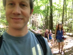
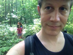
Yesterday, the family and I went hiking at Keown Falls and John's Mountain.

We actually left the house at like 2:30 in the afternoon, but since both of the girls are teenagers, that counts as "early" on the weekend, and both slept for like half the trip.

Early

I guess that's better than the alternative of complaining that it's taking a long time though, so I wasn't upset about it at all.

Boy, did it take a while too. I forget how far north is is to Resaca. It seems like it's just past Red Top Mountain, but no. It's much further north than that.

I guess it's been a while.

The roads made Kathryn pretty happy though. No protracted twisting and turning. There was a bit at the north end of Pocket Road, but no worse than our neighborhood. Even the forest road up to the trailhead was easy on her.

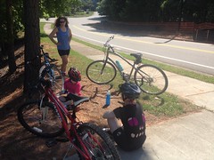
We parked, changed, got geared up, and hit the trail by 4:30 or 4:45, I think.

Actually, wait, there was something else I did first. My left achilles tendon has been killing me for weeks and weeks. Whatever damage I did to it has mostly healed and normal shoes don't bother it, but after putting on my hiking shoes, I could tell right away that they were going to be a problem. What the heck? Well, after looking closely, the left shoe had more of a lump in it where it holds on to your foot than the right shoe did, and the lump in the shoe sat directly on the spot that my heel hurt. I remember whacking my heel, so I know the shoe didn't cause the problem to begin with, but it sure wasn't helping. Enough taping up my heel though, I cut open my shoe, picked all the foam out of it, and taped up the shoe. Success! Now the left and the right shoe are exactly the same thickness and neither bother either foot. Ha! I fixed it.

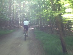
So, after resolving that, we hit the trail for real.

Right away I spotted this Shagbark Hickory, though at the time I wasn't sure what it was.

Shagbark Hickory

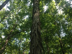
I mean, it makes sense to call that Shagbark, for sure, but I think, in the past, I may have misidentified some other kind of hickory as Shagbark. I think of it as having normal-looking bark that grows really, really thick. I have a photo of John on Cold Mountain demonstrating the depth of the bark on what I thought was Shagbark. I'm going to have to do a little more research though. Maybe it does have thick, deep bark at the base, which turns into those strips further up, or something.

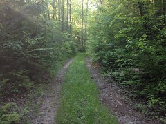
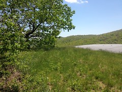
The Keown Falls Trail is a lasso, or lollipop, and most people only hike half of it, out to the falls and back, on the right hand side of the loop part. I wanted to hike the whole trail though, so we hung a left where the stick (of the lollipop) hits the loop.

The Pain Train

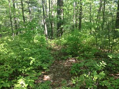
It was definitely the road less travelled. The trail was clear, but it wasn't possible to walk down it without constantly brushing against leaves and grass. Through some miracle of genetics, neither Sophie nor I are allergic to Poison Ivy or Oak, but Kathryn and Iz have a normal, terrible, reaction to it, and it was freaking everywhere down in the flats. Between that and worrying about picking up ticks, neither of them wanted to be there, at all.

Fortunately we climbed up out of that garbage pretty quickly.

Unfortunately, the climb was rough and we had to take a break after the first set of switchbacks.

While we sat there though, a couple came down the trail from above and we talked to them for a few minutes. They were hiking the Pinhoti in sections and were on that section that day. I think it reassured my family a bit that we weren't completely alone in going that way.

The overgrowth slacked a bit as we climbed, and there was way less Poison Ivy and Oak, and though Kathryn and Iz weren't exactly happy, they could just walk, for the most part, without having to carefully twist around crap hanging out into the trail.

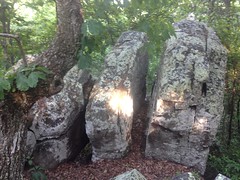
Before long we arrived at the first set of cliffs.

The Family at the First Set of Cliffs The First Set of Cliffs

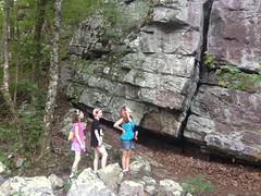
The rocks below the cliffs were a really cool color of lavender. Me and Sophie climbed all over them but I failed to take a photo.

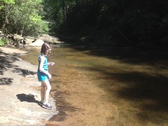
A little trickle of water that runs over the cliffs themselves, but you can't really see it in this photo.

The Family at the First Cascade

Sophie and I played in the water, but Kathryn and Iz were uninterested in such shenanigans.

We stayed there until I was sure everyone had recovered from the climb. Kathryn had pretty much warmed up at that point too, and didn't have any trouble from there on.

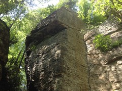
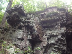
For the next half mile or so, the trail ran along the bottom of a set of cliffs. Lego Cliffs, I like to call them because they look like they're made out of Lego.

They look rusty, and must have a high iron content. The mud at the base of these is all yellow too, and people have graffitied the rock with it for ages.

Lego Cliffs

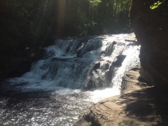
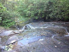
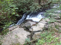
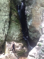
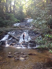
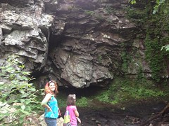
Before long we arrived at Keown Falls proper.

The Family at Keown Falls

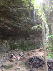
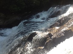
It's really more of a cave with a bit of a trickle running over it. I've only seen it pouring when it is actively raining. Fortunately you can actually see it in the photo though.

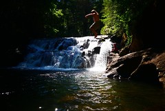
We climbed all over the rocks. Kathryn and Iz have tons of pictures of that.

I stood directly under the stream and got thoroughly drenched. I don't think it was even in the '90's, but it was still warm enough for the water to feel great, and to be completely dry 15 minutes later, just standing around.

But we didn't stand around for long though. We'd gotten a late start, had a ways to go, and didn't want to do it in the dark.

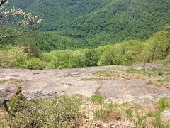
The trail becomes a set of stairs that lead up the cliffs nearby, and there's a viewing platform up there. I'm not sure what you're supposed to view though. You can't really see the valley, and the falls is actually tough to see from it too.

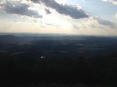
Up to the rocks to right though, is the real deal. From that vantage, you can see a huge swath of the Furnace Valley.

Sophie Looking at the Furnace Valley

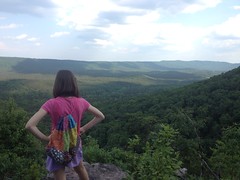
Sophie wanted to know what that mountain on the other side was, and I wasn't actually sure. I used to know... I kept thinking it was John's Mountain, but I knew John's Mountain was behind us. Middle Mountain? That didn't seem right either. Dangit! I had to look it up later when I got home. Horn Mountain! The "Dalton Pinhoti" climbs over Dug Mountain, Hurricane Mountain, Middle Mountain, Mill (Creek) Mountain, Horn Mountain, and John's Mountain. There was a time when I could have recalled that effortlessly... :(
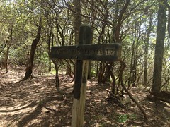
Warning!

Warning

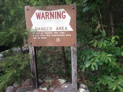
Don't fall over the cliff. Actually, these days it's pretty well overgrown behind the sign, but I can imagine it wasn't always.

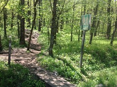
We picked up the well-marked John's Mountain Trail just past the overlook and took it south.

Johns Mountain Trail

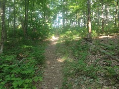
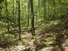
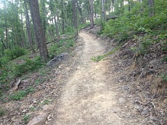
It was fairly clear for a while, but eventually, it started looking more like the Keown Falls Trail had earlier. It wasn't overgrown in the sense that I usually think, but things were always touching you.

The Family on Johns Mountain Trail

Isabel was especially dissatisfied with things touching her.

On the upside though, there were interesting things to see. You pass lots of rock formations up there.

Rocks Along the Johns Mountain Trail

Just past the south end, the trail leads up over some too.

There's an unusual amount of Chestnut Oak up there, if you're into trees. Blueberry bushes crowd the trail too, but the fruit wasn't ready yet. I only saw one berry that was slightly purple.

Some kind of grass grows all along the trail. I remembered it from the TNGA. It grows these spear-like seed-pods that jab into your socks and after a while you accumulate so many that they start to hurt and you have to pick them off. Then they do it again. I wasn't wearing any socks or other clothes that they could jab into though, so ha! Kathryn liked them, and kept picking them open. She said the inside smelled like wheat. I'm not sure I know what wheat smells like well enough to have identified them that way!

There was this raspberry-looking thing up there too, that I couldn't immediately identify.

Raspberry

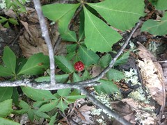
Under-ripe dewberry? Whatever it was, it tasted underripe.

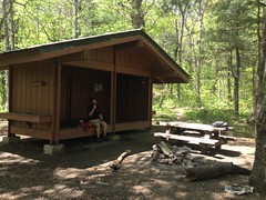
The trail got a bit more clear after a while and we eventually ran into this little building at the base of an antenna.

Antenna Tower

The building was covered in graffiti, and Evan Martin seemed to be the principal author.

Evan Martin Needs to Stay in School

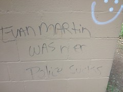
Evan Martin needs to stay in school though. He should especially consider paying attention in Grammar.

Just past the blockhouse we passed a leaky propane tank.

Leaky Propane Tank

Someone really needs to take a look at that tank. It's definitely leaking.

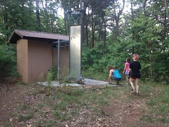
Past all of that, the trail connected up with whatever that road is on top of John's Mountain.

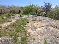
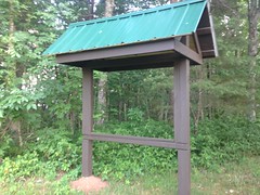
There was a brand new Kiosk up there. So new it didn't have any signage on it yet.

New Kiosk

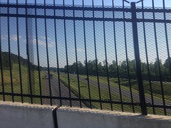
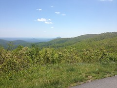
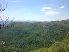
To the left was another observation deck.

Approaching Johns Mountain Overlook Johns Mountain Overlook

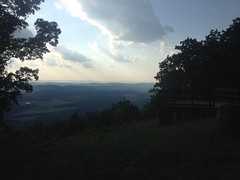
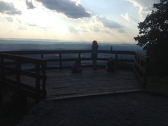
But this one actually afforded legitimately amazing views of Taylor Ridge, Pigeon Mountain, and Lookout Mountain beyond that.

Ridge and Valley

Geographically, this part of Georgia is called the Ridge and Valley Region, and it's certainly clear why it's called that from overlooks like this.

We hung out there for a while until everyone was feeling good again. When we got going again, the trail was an old roadbed, wide open, and well travelled. This made Kathryn and Iz much happier. Especially Iz. With no little sprigs constantly touching her she seemed to actually enjoy our little walk rather than just enduring it.

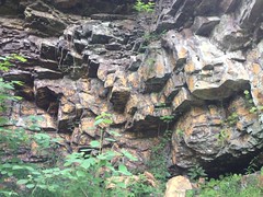
The trail led directly to the top of the falls, and it made me wonder again whether the cave and those cliffs were natural or man-made.

I guess they could have formed naturally. Ice likes to split that kind of rock into blocks like that. I've seen it all broken up on its own all over the place, just not to such an extent. Also, rock is usually quarried in concave faces, directly off of a road. Plus, you usually see signs of blasting and drilling. Though, that's what a semi-modern quarry looks like. Who knows how they did it 100 years ago. They mined iron ore on nearby Pigeon Mountain 100 years ago with mules and a light gauge rail. I could imagine a similar rail running along the ridge where the road is today and the rest of the work done with donkeys and mules. The Alum Cave in the Smokeys is an old alum mine. It was mined by man, beast, and rail, and all that remains of it is a similarly undercut cliff. I know the falls is named after George Keown who surveyed the area for the Berry family (or something like that), but I've never read anything about the history of the area itself. Hmmm....

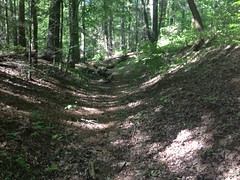
Stairs lead down the cliff to well below the falls. Below that, I remembered the trail being a set of switchbacks, so badly cross-cut that the trail itself slopes down into the cross-cuts and given the crumbly surface, it's easy to slip. Sophie actually did slip the first time we were there.

But!

The cross-cuts appeared to be completely overgrown, and someone had recently rerouted the switchbacks into a single, long, light-dozer-cut switch.

Keown Falls Dingo Trail

It looked really new. Like less-than-6-months new. I guess that's some of the work that came out of the co-trails assessment. The work looked good - grade reversals and rolling dips. I'll have to come back in a year or two and see if it looks a little more natural then.

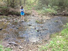
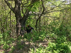
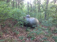
The new trail teed into the old trail at the creek and a little further down we ran into this box turtle.

Turtle

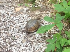
Just sitting there on the trail.

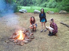
And that was about it. We got out before dark and the drive back was easy. We stopped at Shoneys off Hwy 140 for dinner. I hadn't eaten at Shoneys since pigging out on the breakfast bar every week in college, and I was surprised how good their hamburger was. I didn't remember their food being all that good, just cheap, thus not going there, but it was, good and cheap.

Hmm.

I might have to start eating at Shoneys again.

Blanket's Creek and Rope Mill

I've done the Blanket's Creek - Rope Mill combo so much that I don't even write about doing it any more.

But.

My brother John had never done it until this past weekend. So, I guess that's worth writing about.

We'd tried to ride it the weekend before, but just couldn't make it work out. It had rained all day Friday, rained again Friday night, and then he was busy late Saturday through the end of the weekend.

But.

This past weekend it worked out great. We met around 4, and got on the trail by 5. Got to love the summer. You can start riding at 5 and still have nearly 4 hours of light.

John's gear bike is hurting right now so he brought the single speed.

1gle speed

Or onegle speed as I was calling it that day. Blankets is pretty good on the single speed, and I imagine Rope Mill is even better.

We rode Dwelling and Van Michaels first, then headed out and over to Rope Mill.

Shred

The singlespeed did kind of suck for a short little bit on the road, I think. There's a quarter mile or so where he was spun out, and then another quarter mile where he had to stand for most of it. But, hey, that's the game.

Crossing 400 always makes it seem like an Adventure, and this time was no exception.

400

On the way down to the trail, we passed a guy walking. He had no shirt, and what appeared to be one working eye. He was so well tanned that I thought maybe he didn't own a shirt. He spoke like a crazy old coot, but his words were substantially more sensible than his tone of voice would predispose you to imagine. He was trying to figure out how to get to the "wider part of the river". He'd been down to the park and that wasn't where he wanted to be. Oddly, he seemed to think that the river was wider upstream, or at least wider in the direction he was pointing, which was upstream. I reassured him that he had been, in fact, heading in the right direction, and that the river gets wider as it approaches the lake, not upstream: "Keep going down this road, hit the river, stay right, follow the river. It gets wider and wider as it approaches the lake." For this I received a sideways high five and he was off!

He had no belongings with him, and from his lack of geographical insight, clearly wasn't well educated, or local. Why was he so interested in "where the river gets wider"? Clearly not to fish. Train tracks border the back of the property though, and I've seen people that more clearly ride the rails along that road from time to time. Best I could figure, he was one too. There could be a camp down along the river. I've never seen it, but I really haven't looked. His belongings might be stashed in the woods somewhere while he finds it...

This made sense to me at the time, but really, who knows?

John had literally never ridden any part of Rope Mill, and given how much I have, that seemed crazy. I guess he's never ridden Allatoona either though. But, I've never ridden Cochran Mill, so maybe we're even.

Rope Mill was fantastic. We had to ride the less fun direction, but it's hardly not-fun, just a little less fun than the other direction. Actually, I shouldn't say that. The Mill part is less fun, but I like the Explorer trails more in that direction.

We ended up riding whichever the green trail is twice because I screwed up the turn on to whichever the blue trail is, as I have done several times, and never seem to be able to get right in that direction. No big loss though. John described it as the perfect no-brake trail, and I suddenly realized what I've been missing for the past year and a half...

We used to have this philosophy about not hitting the brakes. It wasn't just a goal, it was a way of life. It was a key differentiator. I was off the mountain bike for over a year and a half, but I made a serious effort when I was back on it, and felt like I recovered all my skills and most of my strength. But no! Ha! That was the missing piece. Brakes. Or rather lack thereof. How could I forget? And, what a difference! Stay off the brakes Dave! Just making the effort made the second lap noticeably easier than the first. Maybe not materially faster, but it took way less effort. Ha! God, I've been fighting myself all this time...

So, after that little revelation, we shredded that blue trail that I forget the name of, and then the Explorer trails as well, before heading back over to Blankets.

The ride was great. John was impressed with Rope Mill. I was impressed that I was able to stay on the gas all day. If it had been a race, I wouldn't have completely embarrassed myself. I say "completely" because my tiny wheels would certainly have embarrassed me some amount, but my lack of cratering would have averted total humiliation.

I'm thinking pretty seriously about doing the Race to Sunset. I guess if I do, I'll have a chance to find out for sure.

Alpharetta Greenway

A while back Iz mentioned that we really ought to ride bikes together one of these weekends rather than hike, and the weekend of the 22nd seemed like the right weekend to do that, so we packed up the cars and headed up to Alpharetta.

Yes, cars. For the first time in 18 years my primary vehicle has no bike rack, nor means of attaching one. I did a bunch of research though. It is possible to put a rack on it. In fact, the rack and clamps that I already have should work, but it appears that I need some longitudinal rails from a company that doesn't exist any more. The rails are still available though, on Amazon or eBay, or other such sources. I may have a working rack soon, but in the mean time, it takes both cars to transport 4 bikes and 4 people.

We had a reasonably good ride, though rather slow for Kathryn's taste. Sophie's still cranking around on the old 30 pound, 24-inch mountian bike we got her in like 2009 I think. She's still small, and it still fits her. Everyone else has a real bike though, and she can't keep up. It might be getting close to real-bike time for her too.

We rode to the north end and took a little break under the same tree we took a break under the last time we were up there.

Greenway Break

Kathryn looks like she's striking a pose on purpose, but that's just her natural showmanship.

The ride back was a little faster, as it's a net descent.

I'm accustomed to leaning on the bars and spinning all day, but Kathryn and Iz were really tired of it by the time we got back. Yeah, it might be real-bike time for Sophie.

Friday, May 20, 2016

Dick's Creek Falls and Crow Mountain

A few weeks ago I'd taken the family up to Long Creek and Sea Creek Falls, and they had a pretty good time, aside from Kathryn getting relatively carsick from driving on twisty roads all day. The week after we all walked on the Alpharetta Greenway for a bit and had an equally good time. Last week we were talking about reprising those good times by going back up to the mountains again, and I thought I might be able to get us in to a spot that didn't involve too many mountain roads.

My plan actually worked, and Kathryn wasn't feeling the least bit sick as we arrived at Dick's Creek Falls.

We were nearly alone though. That place is typically packed, but I guess the water was just a little too cold, and it was vacant except for a few fishermen and errant folks like ourselves.

The Girls and a Guy Fishing at Dicks Creek Falls The Family at Dicks Creek Falls Sophie at Dicks Creek

The falls itself raged with a power I hadn't seen before.

Dicks Creek Falls Dicks Creek Falls Up Close

I guess I'd only been up there during droughts in the past.

After climbing all over the nearby rocks, and wading barefoot in the creek, the next logical thing to do was go for a swim.

Damn, the water was cold. But, after a few dips I got acclimated, and after a few leaps from the lower ledges, I felt confident I could leap safely from the Cliff of Death.

Kathryn had brought her new camera. Iz was perched pensively on the rocks nearest the falls. Kathryn had an artistic photo framed, and right as she took the photo, my ridiculous flailing body came sailing in from the right.

Photobombing from the Cliff of Death

She still got her shot, but I bombed her first attempt.

We stayed there for a few hours, actually. I enjoyed being in the water. The girls seemed to enjoy NOT being in the water. Kathryn shot a satisfying number of photos and got fairly familiar with her camera.

But that was just the first part of the day. We planned to go for a walk too. I'd read of another waterfall on Crow Mountain Creek, and the old USGS topo maps show an old road leading up to it. The girls and I had explored an adjacent set of trails 8 or 9 years ago. I figured we'd hike up Old Crow Mountain Road and come down the old road that parallels Blood Mountain Creek.

A few miles, tops.

We were all up for it. Let's go.

We hiked up the road and hung a right onto the old road. This seemed to take no time at all.

The old road was steep and chunky, and deep below grade, but clearly got some amount of traffic. From the looks of it, a good bit of horse traffic.

Old Crow Mountain Road Climbing Old Crow Mountain Road

Sophie's blood sugar started crashing, but I managed to catch it before it got too bad, and she was feeling fine again by the time we got to the falls.

The falls were interesting, but not all that spectacular though, at least not from the top.

Crow Mountain Creek Falls

It was a long, but very shallow sliding falls. I had an easy time walking all over it. It might have been more impressive at the base, but it wasn't a good day to find out so I left that for another trip.

We crossed the creek right after the falls, and Sophie's legs were just slightly too much shorter than the rest of ours for her to have an easy time of it.

Tentative Creek Crossing

It was the weirdest thing too. The old road began to improve significantly after the creek.

More of Old Crow Mountain Road

And then there was a meadow.

Meadow Above Crow Mountain

And then another stretch of even more improved road, with tire tracks.

This was a little confusing at the time. How could the trail be improving. There's no way anyone drives up what we'd been on earlier. There's only 1 road in the area, due west, which mainly runs north-south, and I'd been to the end of it before. There must be a pretty long spur leading east from it over to these meadows, but no map shows any such thing. Hmmm....

I pondered all of this as we walked, but the sudden appearance of an enormous black bear, a 500 pound cinnamon boar, directly ahead of us cast all such thoughts from my mind. "Bear!" I shouted, and raised my arms above my head. Isabel, apparently, had the same response. Good job Iz! Kathryn and Sophie took a second, but at least neither of them ran away, which has always been my fear. The girls and I had only seen one bear together before, on Smith Creek, near Helen, years ago, but it was a long way away, across a deep valley, I noticed it first, and gently informed them about it, so they didn't really react, just respond, mainly with curiosity. Since then I'd always ask them, every single time we'd go for a hike: "What do you do if you see a bear?" "Put your arms up." "Do you run away?" "No!"

We'd never actually walked up on one before though. People say that humans don't act on primitive instinct, but the people who say that have never seen a bear in the woods. I can very confidently tell you that the urge to run is very strong, and without the right presence of mind, you will have begun to do it before you realize that you have. I've seen it happen, and I've experienced the urge myself, but I've also seen enough bear since then to have been re-trained. With the girls, it's one thing for them to be able to recite what to do, but I've always wondered how they would really react. I guess now I know, and I was really pleased to find out.

Bear do act on primitive instinct, and this one took off the second it realized we were there, leaving a trail of droppings in the direction it fled. We literally scared the poop out of it. Reminded me of a tale that my brother told me that Andy Skurka had told him. But that's another story...

Ours continued north past more meadows and along ever-improving trail.

Looking More Like Civilization

One meadow perfectly framed Blood Mountain and gave me a really good idea of where we were. Sadly I neglected to take a photo. We eventually came upon a gate and it looked like the trail I wanted to take back down ought to tee in right there as well. It was nowhere to be seen though. Had I been alone I'd have probably explored around off-trail until I found it. They're not much for off-trail hiking though, and we hadn't so much as pushed aside a branch all day. I gave them the options: "1) Bushwhack until we find the other trail. 2) Direct abort - turn around and walk back down the way we came up. 3) Keep going - we're surrounded by The Blood Mountain Wilderness, the road ahead must bend around and lead to the main road, as there is no other road in the area, and it simply can't lead into the Wilderness." They chose option 3 and we pressed on.

The road just kept going north though and before long we were off the top of the map. The road would bend west promisingly, and then just bend back north. Sophie was especially frustrated by this. Iz and Kathryn, surprisingly, didn't seem to care, and were in generally good spirits.

At length, the road bent back south, and joined the main road at a 6-way intersection. I recognized it. I'd been there before. We still had a ways to go though.

We made great time, and Sophie was in better spirits until she slipped off of a little berm and slammed on her left hip. We thought she might develop a bruise, but it turned out to be just a really bad scrape. It kept sticking to her clothes, so I eventually had to pull out the little first aid kit, clean it up, and bandage it.

Before long we started passing campsites and waterfalls.

Small Falls on Dicks Creek

It was getting late and chilly. We were out of Clif Blocks. I showed everyone where we were on the map and how much further we had to go, and again, gave them options. Option 1 - Push on together. Option 2 - Post up in one of these campsites, build a little fire, I'd go get the truck and drive back up to pick them up.

They really liked option 2.

Option 2!

Fake Camping

It only took 20 minutes or so to get back to the truck and like 5 more to pick them up. But they were relaxing by the roaring fire the whole time, and if they'd come with me, it would have taken like twice as long, and they'd have been burnt. I think we made the right decision.

We packed up, but didn't take off immediately. The fire was warm and cozy. They'd even drug over some logs to sit on. It was getting kind of late though, and the girls had school the next day, so we did get going around 8:30 or so.

We grabbed some Subway in Dahlonega, though I cannot account for why they preferred Subway to Rooster's Cafe. Rooster's has seriously good chicken. No accounting for taste, I guess.

And that was about it. We later reflected on the long list of ironies. My family doesn't value Adventure or Adversity like I do. But... I can't remember the last time I was that wrong about the layout of the trails. I can't remember the last time I had to improvise like that to find my way out of the woods. I can't remember the last time I ended up off-map. I can't remember, offhand at least, the last time someone got hurt. I've been carrying around a first aid kit for years and never had to use it until this trip. I've been carrying around emergency fire-starting materials for years and never had to use it until this trip. Not to mention the bear!

Adventure!

On the one day I was actively trying to avoid it.

Chicopee Woods

The frere and I rode at Chicopee this past Saturday. Unfortunately I have no photos, as I forgot to bring my phone, entirely.

Also, there's not all that much to tell...

We did ride the Coyote loop first, because it's so easy to skip if you ride everything else first. Smart thinking, eh?

I think we both felt pretty weak all day though. We've both been working too hard, sleeping too little, and in his case, traveling too much. We were strong enough to have a good time though. No real suffering, just work. No crashing. No mechanicals. But, I didn't feel like I ripped singletrack all day. It was more like I managed singletrack all day, and that's not quite the same.

I saw the first real wildlife this year though - some kind of water snake swimming away from me during the last creek crossing. I think it was a midland brown, but it was kind of hard to tell.

On that last little last bit of the Tortoise Loop on the way out, John rode over this huge rock that I've never even considered riding over. He and I have ridden there for 16 years and I've never seen him do it either. He alleged that he's done it almost every time though, and he looked really casual and confident when he did it, so it seemed like he was telling the truth. I must have either always been ahead of him, or only been behind him on the few times he didn't ride it.

So weird.

Man, I wish I could remember more about the ride. I guess photos usually jog my memory. Or, maybe if I hadn't waited so long to write about it...

Ehh, sometimes it's like that. We're planning on riding Blankets/Rope Mill this Saturday. Maybe there'll be a good story to tell for that ride.

Raven Cliffs Wilderness

Oh, goodness, again the backlog grows...

Lets see... A few weeks ago Billy suggested that we do some hiking together. This was an odd request as though we have known each other for like 15 years, we have almost exclusively ridden bikes together, and never once walked in the woods, except on the rare occasion that we could not ride some particular thing.

Sounded good to me though, and as Billy is generally down for High Adventure, I knew just the place.

Billy at Raven Cliffs Falls Me at Raven Cliffs Falls Cliffs Near Raven Cliffs Falls

Those who know North Georgia will most likely think something along the lines of "I recognize that as Raven Cliffs Falls, one of the most popular and easiest hikes there is. What is this High Adventure, of which you speak?"

Well, it started with an ascent of the cliffs themselves, via the old root system dangling down the far side. The last time I made that ascent was probably 6 or 8 years ago, and it was decidedly easier back then. I think next time I'll try a different route. We wandered around the top of the falls for a while and I guess I was caught up in the moment, because I failed to take a photo of the upper (and far more spectacular) cascade.

There's an old skid road up there that ends abruptly and once made me wonder if there had been some kind of flume or other contraption in operation back in the logging days. Looking at it again just made me even more curious, but no clear evidence remained, one way or the other.

Following the skid upstream involved a great deal of work. Judging from the abundance of downed trees, density of the underbrush, and absence of limbs from the trees that were still standing, it appeared that a tornado had touched down in the vicinity, some years ago. We had a very difficult time following the old road, and when it ended, making further progress upstream was even more difficult. Downed trees crisscrossed the creek. There were several small cascades. The hillsides were dense with the same thorny underbrush and even more downed trees.

Billy's triumphant Canadian beard defended his face, while my pathetic stubble actually seemed to attract injury. I ended up getting several little wounds that I didn't notice at the time, but looked pretty bad in the mirror the next day. I'm pretty sure some people I know wondered just what the hell I'd been up to all weekend.

It took over an hour to push less than a quarter of a mile. But, then, suddenly, the woods opened up and we walked through it along the side of the creek without touching a single bit of brush for at least a mile. There was even a fresh campsite along the creek. I doubt whoever camped there came in the way we did though.

Eventually the woods got a little more dense, but it was still very easy going.

Open Woods

Uphill was Hogpen Gap Road, and I was aiming for an overlook near the gap.

A bit southeast of our destination, I found this frisbee, lying on the forest floor.

Frisbee South of Hogpen

There was even a name on the back of it: Andy Taylor, and a local phone number. Well, local to North Georgia, at least. I imagined the Andy's jerk brother standing at the overlook thinking something like "It would go for miles..." and giving in to the urge to find out. Then Andy, realizing that it was HIS frisbee his brother had thrown, tackling him to the ground and wailing on him. Ha! Served him right. I called the number twice and left a message. Nobody ever called back. Andy Taylor, if you happen to read this, email me or something, I'd be happy to mail you your frisbee.

We hit the overlook, right on target.

Overlook South of Hogpen

Here's billy scrambling up the last little kick of rocks.

Billy Scrambling Out of the Wilderness

And look at that glorious view.

View from the Overlook South of Hogpen

That's Mount Yonah way back in the distance.

I bet a frisbee would go for miles...

The AT was just a little ways up the road.

AT at Hogpen

We arrived at the intersection at exactly the same time as a lady hiking up from the nearby water trail arrived. She looked like she had a long way to go but she also looked like she was feeling pretty good about it. No blank, vacuous stare, at least.

It's a steep climb up to the ridge that divides Hogpen and Tesnatee Gaps. Fortunately there are switchbacks, but it looked like that hadn't always been the case. If I remember correctly, there are a ton of steps on the other side, and it's much more difficult.

A trail runs along the ridge, out to the Whitley Gap Shelter, and beyond.

Whitley Gap Shelter Sign

The last time I was up there was when I hiked the Logan Turnpike and had to run full speed toward the shelter to keep from getting struck by lightning on the exposed granite. This time the weather was a lot nicer.

We took a little side trail down to a granite outcropping...

Granite Outcropping on Whitley Gap Trail

...and you could actually see the next ridge over, Cowrock Ridge, I think.

View from Granite Outcropping Along Whitley Gap Trail

I don't think of North Georgia has having much in the way of cliffs, except on Mount Yonah, but I could see several from that little outcropping alone. Hmmm...

Further on there was even more exposed rock.

Billy on Whitley Gap Trail

And eventually we got to the shelter.

Whitley Gap Shelter

I had plenty of Clif Blocks, but I'd apparently forgotten to bring the Skittles and Beef Stick that I'd bought on the way up. Dangit! I'd been thinking about those delicious snacks for the past hour, and I didn't even have them. Fortunately Billy didn't forget to bring some kind of peanut, M&M, and raisin mix and shared some of it with me. It wasn't the super sugary and salty goodness that I'd been craving, but it was a lot better than just eating a bunch of Clif Blocks.

Our break lasted a half hour or so. I lay on my back most of that time, and It's not impossible that I slept for a few seconds at some point. Nothing better than relaxing in the woods.

Ahhh.

But, we were only about halfway done and needed to start making some progress lest we get caught out in the dark.

A trail led south along the ridge. I'd once read, in a really old book that had once been part of the Knoxville Public Library collection, but that had made it into my hands via a most circuitous route, that the trail led up to Adams Bald. The book described it as a "fairy land" up there (no kidding) where all the trees looked like miniature versions of themselves.

Sounded interesting.

Unfortunately the trail, decidedly, did not lead up to Adams Bald. Rather it sidehilled below it and eventually petered out along the ridge that led away to the east. It's not impossible that an older branch of the trail once led up to the top though. There were a few downed trees, and if one had fallen at an intersection, we might have missed it. I might go back to look for it in the future, but there was no fairy land that day.

Along that ridge, I made the standard mylar baloon find.

Mylar Balloon On Adams Bald Ridge

Which, at the time, seemed overdue.

The trail ran and ran.

Trail Along Adams Bald Ridge

Someone clearly used it.

But it eventually disappeared into the underbrush and we were resigned to just follow the ridge for a while.

Me and Billy Bushwhacking

The terrain there was fairly easy to follow. We dropped off of the ridge down to a creek, which apparently falls over some more exposed rock, in what must be a fairly spectacular display. I only noticed this later though, looking at our GPS data on top of some aerial photos. At the time, we could see that the creek dropped off to the right, but we couldn't see the cliffs themselves from above. Dangit again! I know how to get to the bottom of the cliffs though. I'll have to go check that out some day.

On the other side of the creek we picked up an old skid which led to an old road, which led to another old road that I knew from finding it a few weeks earlier, and that led back to FS244.

Woohoo! "Civilization"

Across the street, we took some trails down to the Upper Cascade of Davis Creek Falls. A very-tattooed couple with a pair of cute dogs were hiking out as we were hiking in.

Me at the Upper Cascade on Davis Creek Falls

I was telling Billy how the trail in the other direction was the 2nd sketchiest thing I'd ever done, but then we found another trail that might be even sketchier. I'm not sure how I missed it the last time I was up there, but it appears to lead down the same rocky face that the falls cascades over. We didn't have the time or inclination to find out for sure though. Maybe next time. Or maybe not :)

I also noticed some interesting "tree art" that I hadn't seen the previous time either.

Tree Art

There are actually 2 different hearts, in two different trees, in that same area. The other one is on the Raven Cliffs Trail, just after it joins the old railbed for the first time. I always assumed that one had formed naturally when a branch broke off, but this one was clearly man-made, so maybe the other one was too.

At any rate, that was our Adventure. It seemed Billy had a reasonably good time of it. My left Achilles Tendon was freakin' killing me near the end, but other than that, I had a good time too.

I don't think I've eaten with Billy once after a ride (or now hike) since he got married. He always wants to get home to eat with Megan, which is admirable, actually. I was starving though, and had to roll up on the Big Zack Snack in Dawsonville. Mmmm, Big Zack Snack. Ideal recovery.