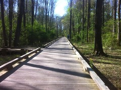
My brother travels a lot and regularly gets to tie in some backpacking to the end of the trip. He's been all over: Rainier, Teton, Yellowstone, Superstition and those are just the ones I can remember off the top of my head. Actually, there's one more that I can remember: The Grand Canyon. He's been there twice and tried to get me to meet him there both times. Some semi-last minute thing has always gotten in the way but this year we planned it thoroughly enough and far enough in advance that it seemed really likely to work out.
Then, my sister-in-law had twins and Kathryn needed to spend a few weeks in Baton Rouge with her after the birth. As things that can get in the way of a trip go, that's about the most understandable one, but still, once again, it wasn't looking good for the Canyon. Kathryn worked it out though. She went down a week before the kids were born, stayed for two weeks after then came home the day before I flew out. As such, for the three weeks leading up to the trip, I had the girls to myself and zero opportunity to ride, hike or otherwise run around in the woods by myself. It wasn't too bad though, and the kids and I did manage to get in a couple of excursions.
On the evening of March 14th, right on schedule, Kathryn showed up at Mia's Pizza, halfway through Trivia and that night I pulled my little pile of gear together.
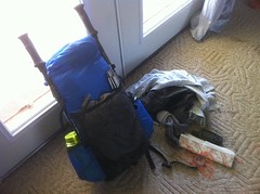
Adventure was imminent.
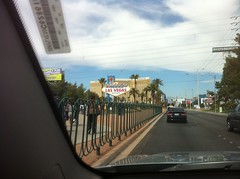
The next morning, I took MARTA to the airport and caught an early morning flight to Las Vegas.
At the airport, I managed to get in the first real hike of the trip: the cab line. There are a dozen hotels in Vegas, but apparently no shuttles to any of them. You have to take a cab. There were hundreds of people in the cab line which snaked back and forth between what had to have been 2 miles of retractable barriers. The line moved quickly though and as soon as I was in the cab, it became clear why there were no shuttles...
"Where do you want to go today?"
"Mandalay Bay"
"Do you want to take the quick route or the local route? The charge is the same. Anywhere you want to go, anything you want to do, anything you want... no judgement from me. Are you sure you don't want to take the local route?"
He got a little more direct as the trip went on. A good friend of mine was a cabbie in Atlanta for a while and according to him, they get "commissions" from bars, clubs and escorts, so they promote them as much as possible. I had a guy in Oklahoma City try to sell me hookers so hard once that I got nervous about whether he was going to let me out of the cab or not, but that's another story.
I took the quick route.
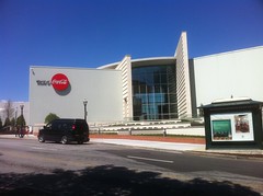
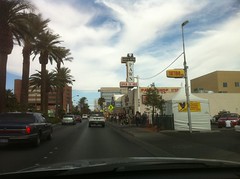
John was working a trade convention at the Mandalay Bay. I met him for lunch but I had about two hours to kill before we could leave town. I wandered around the casino a bit but there was one place in particular that I really wanted to see so I took the rental car and headed up The Strip.
My kids and I watch Pawn Stars together all the time. I sent them the photo and they were reportedly very excited to see it. The line outside was long though so I didn't even try to go in.
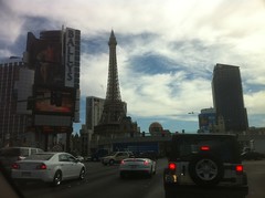
There's all kinds of crazy stuff on The Strip. Classic casinos:
Modern insanity:
The most interesting thing I saw though was a lady in a sexy green corset with a shelf bustier, a green top hat and a full, though hopefully prosthetic, red beard. St. Patrick's day was coming up and she was apparently a Leprechaun. It was confusing. She looked pretty good, but then there was that beard... but still, pretty good... but no, the beard! Aaaah!
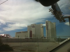
I was surprised by how small Vegas is, given its fame. Baton Rouge might be bigger. I guess big things come in little packages though, it sure is popular.
A few hours later I picked up my brother and we blew town directly. Unfortunately we went the wrong direction for about 20 minutes before realizing our error and getting back on track. It is some small consolation that it may run in the family but still, don't trust me to get you anywhere.
You can't get to the Canyon from Vegas without crossing the Colorado River, and in years past, you had to cross the Hoover Dam.

These days though there's a massive bridge on the highway and you have to make a specific side trip to see the dam.
The one thing that I really wanted to get a photo of was the crazy bent power line towers. I'd seen them a million times on TV and in movies. They're so crazy!
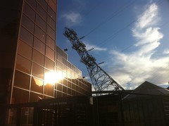
What the heck?
Actually it makes sense up close, the lines come straight up from the powerhouse below and if the towers didn't lean over, there'd be no good way of getting the lines up over the top of the cliff. Still though, they look so wrong, like any minute they'll go tumbling down into the gorge.
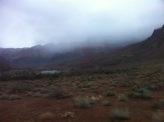
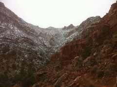
We made it to the Canyon a little after dark and with the cloud cover, unless you just knew it was there, you'd never know it was there. I could see about 10 or 15 feet below the rim but there was nothing to suggest the yawning crevasse that I'd wake to the next morning.
We had a room at the Bright Angel Lodge. The bar was still serving burgers so we grabbed some quick dinner and hit the sack.
We were up and moving by 6AM the next day. John called a cab and it arrived at the curb before I could even get outside the building. It was so prompt in fact, that the driver and I had to wait for a few minutes while John finagled a cup of coffee out of the not-quite-open-yet restaurant down the hall.
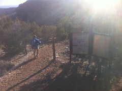
We headed east to Lipan Point and the head of the Tanner Trail, the easternmost trail into the Canyon on the South Rim.
A few seconds into the ride, John was like: "I think I hear double-bass, crank that up." This totally made the driver's day. He'd been listening to Avenged Sevenfold and Slipknot but had turned it down when we got in. He'd had fares ask him to turn it off entirely but he'd never had anyone ask him to turn his music up before, let alone sing it with him for 20 miles. It was a great way to start to the day.
At Lipan Point we took in the view for a few minutes. I took some photos but the camera in my phone really sucks at high contrast shots. The sun was still low, most of the canyon was in shadow and it just came out pitch black in the photos. Dangit.
Speaking of bad photos...
1, 2, 3, Go...
"Alright, don't blow up on the descent."
"Ok."
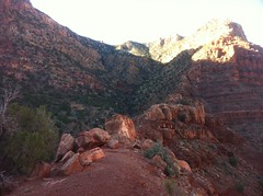
It was in the 20's at the rim, the first few hundred feet of trail get relatively little sunlight and as a result, the first group of switchbacks had a thick sheet of ice on them. I've walked all over the icy streets of my neighborhood but this was a whole new deal and it took me a while to get a feel for it.
John's walked all over that kind of stuff before and it didn't appear to be a problem, so watching him I was at least confident that it could be done. He walked where the ice was dirty or scuffed up, went from rock to rock, kept moving, did some kind of weird toe-to-heel forward-moonwalk to distribute his weight, took quick little steps, made generous use of his trekking poles and so on. These things all seemed intuitive to do, but I couldn't execute them very well and on the second switchback I ate it and bruised my left forearm, tricep, hand and shoulder and somehow tweaked my right knee. The right knee was especially bad because I'd been having pain and stiffness in it since the last long bike ride and also not two days earlier, smashed it into a chair while getting up to answer the phone. Woohoo!
I learned my lesson though. I'd been using the poles wrong. You've kind of got to lean into them and really commit to it, which is not intuitive. It seems like you should kind of lean back and use the poles to keep you upright but that just makes you rotate backwards around your center of gravity and pulls your feet right out from under you.
I'd figured it out, but we ran out of ice before I'd gotten enough practice to feel really confident.
The descent was steep, maybe even steeper than Old Butt Knob and with the ice, nearly as slippery.
The switchbacks gave way to an endless series of makeshift stairs and rocky scrambles and before I knew it we were about 1000 feet down, looking back up at the progress we'd made.
We descended more of the same, hit a flat spot for a while and ran into a few hikers on their way up.
One of them had the heaviest Maine accent I'd ever heard. So heavy I thought it was fake at first: "You boys heard there's a storm a-comin' eh?"
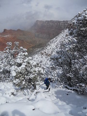
We had. Or rain at least. Rain in the Canyon, snow on the rim. About 2 feet of snow in fact, but it was supposed to come in on Monday and be done by Tuesday. We were heading up on Wednesday. If we kept to our schedule, it wouldn't be a factor, unless it hit early, and then we'd just have to play it by ear.
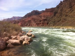
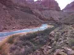
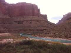
A little under halfway down we stopped at an overlook and got our first good view of the Colorado River, the big chisel itself.
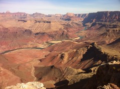
Most notably the water was green. It's usually a muddy red or brown, thus earning the name "Colorado", or "colored" in Spanish. Being green meant that the water would be pure, clear and delicious. There are dozens of feeder creeks for the Colorado but they are almost always dry except in the dead of winter. The Colorado itself is the main source of water at the east end of the Canyon.
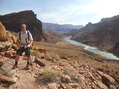
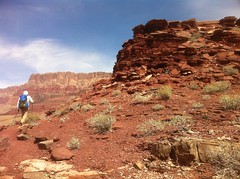
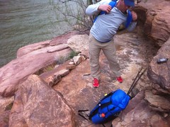
John snapped a photo about halfway down and I got one of him too.
I'd been trying to keep a sane pace, but I also had to keep up with John and he is substantially stronger than me. At that point I was still feeling OK but within a mile, it was a totally different story. I needed to slow down. I just wasn't getting enough rest between each step. I'd gotten all I could out of alternating strides. It'd been forever since I last used trekking poles, but I'd figured them out again and gotten all I could out of them. I had energy and strength but each step hurt a little more than the last. I didn't feel like I was slowing down but John pulled way ahead. If I could push on to the bottom, we'd stop for lunch. Maybe I could recover a bit, maybe I could hit the reset button.
John had stopped to wait about a mile from the bottom and we walked the last bit through the dry wash of Tanner Creek and the sandy, yet still incredibly rocky beach together.
The creeks wash boulders into the river, so there are generally rapids just downstream from each of them. In this case, we got a nice view of the aptly named Tanner Rapids and the first good view of the Canyon itself from the bottom.
I cooked some potatoes. John was disappointed that I'd brought food that needed to be cooked for lunch. He wanted to eat and walk. We'd discussed our food plans weeks before and I thought I'd told him that was what I was going to bring, but maybe he thought I meant for dinner. He had sent me a spreadsheet with his plan in it and he was going to eat cold lunches but I didn't realize what that meant for me. Maybe he did say something and I missed it, or forgot it. I don't know. I ate fast.

After lunch we headed east on the Beamer Trail. My feet hurt and my right knee hurt but I had plenty of energy. I hoped for some recovery on Beamer, and for a little while I got it. If we were climbing or if it was flat, I was fine, it was the short, steep, jumbly descents that hurt the most and I invariably fell back on those. For the first few miles though, there were precious few and though I didn't get any better, I didn't get any worse either. Every step hurt but it wasn't injury, it was just hurt and given the number of hours left in the day, I knew that I could keep pushing through it as long as I got some sleep that night.
The Beamer trail had many different flavors. There were wide open sections on decomposed shale or sandstone.
There were sections where we followed a natural shelf and though it would have taken some effort, one could have potentially flung ones self into the river some hundred feet below.
There were long sections of beach sand too.
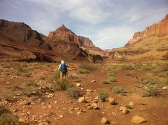
The Palisades of the Desert rose to the right and across the river on the left there were enormous buttes.
I was surrounded by fantastic geologic diversity and not 100 feet to the left there was a massive river, of all things, in the middle of the desert.
It was all lost on me though. The hike had become a death march.
In the soft, slow sand, John had begun to pull away again and I swear to God I was pushing as hard as I could but there was just no catching him. I mean, yeah, I could have taken off jogging or something... I guess what I mean is, I was going as fast as I could imagine sustaining for even another hour and I'd long given up on trying to keep from trashing my feet or joints. Every step was agonizing, and I was still falling back.
It was disappointing. I was disappointing. We had a route planned that he could clearly finish on his own but with me along it was looking less likely every hour. I couldn't keep up. I just shouldn't have been there. Worse, so I could go at all, Kathryn had to shift her plans and her family had to accept the shift in her plans. If I hadn't gone, everything would have worked out for everybody.
It was a train wreck in every direction. Do you ever hate yourself? I do. Sometimes I end up hating myself in middle of nowhere when there's no way to fix it.
The best I could do was keep hammering. It hurt like hell but I was confident that I could keep it up. It wouldn't be fair not to. John had coordinated the trip, researched the route and paid for nearly all of my expenses - he'd bought my ticket with skymiles, I was mooching off of the rental car and hotel rooms, he'd even picked up dinner. I'd paid for the food I was carrying and one checked bag. It already wasn't fair that I was dragging back. It would have been even less so to complain or try to negotiate a new plan. The most reasonable thing to do seemed to be to shut up, keep driving and if we get delayed, let it be because I physically couldn't walk far enough in the time we had, but not because I just decided not to. In the absolute worst case, there were 5 exits ahead of us and I had an extra day of food. He could let me go, I could post up for a day and take one of the exits up. I prayed it wouldn't come to that.
When I got to Palisades Creek, John had the map out.
"We've put in some pretty fucking pussy miles so far today."
"Yep."
We stopped for about half an hour, drank, ate, rested and took on water.
The plan had been to get to the end of Beamer and back to Palisades that evening but even at John's normal pace we didn't have time for that any more. We could probably get to the end though.
On the map, Beamer looks pretty easy. It looks flat and appears to follow the contours, presenting only two climbs and two descents of a few hundred feet each. The route description indicated that it was easy between Tanner and Palisades Creek and that beyond Palisades, it would become arduous. We were sitting at Palisades. It was about to become arduous.
In fact, "arduous" doesn't begin to describe it.
You climb 300 feet, then follow ledges of varying widths in and out of 16 different canyons. In each canyon, you have to climb either up or down some gnarly pile of talus, cross a pour-off...
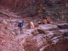
...and then climb down or up another pile to get back on the next ledge.
In the first or second canyon, we encountered a group of 4 hikers coming back from further out. They'd come down Tanner like we did, camped at Tanner Beach, then done an out-and-back on Beamer. They didn't get to the end, but turned around when they were halfway through the day. We talked briefly and they seemed to be really cool people, but we all had a long way to go and none of us wanted to sit around for long.
Across the river there were two buttes - Temple Butte was the first and I forget the name of the second. It took an eternity to get past Temple Butte and the second one was a little larger. The Beamer Trail ended past the second one and I started to worry whether we'd be able to get to the end by nightfall. Without a light, it would have been really sketchy on that trail at night and we started keeping track of potential spots to camp.
The experience of the trail itself is a good enough reason to hike Beamer, but there are actually several points of interest out that way too. At the end of the trail lies the historic Beamer Cabin as well as the confluence of the Colorado and Little Colorado Rivers, marking the beginning of the Grand Canyon proper. On top of that though, in 1956 two airliners collided over the canyon in the worst air disaster in history. The incident spawned the FAA and though the debris has long been removed, the crash sites are visible from the trail and you can stand there and imagine the difficulty in getting to them. We passed the first site that day, where TWA Flight 2 had gone down. John had done some plotting to figure out where it was on the map and it wasn't hard to spot it on the butte.
We pushed to within a half mile of the end and though the sun had long been down, we still had plenty of light when we reached a little beach with a clear trail leading down to it. There were plenty of camp sites on the beach, but the wind was really blowing and sand plus wind usually equals no sleep so we looked around a bit. A few hundred yards further east along the shore we found a big, flat ledge with a wide boulder on the windward side. There was no real danger of rolling off into the river, but John placed some rocks along the outside edge to warn us if we got too close just in case. The sky was clear and there was no rain in the forecast that night so after a short meal, we just slept in mats and bags under the stars.
The stars were impressive too. We could see them all. In particular though, two planets were very visible. Someone told me earlier this month that they were Mars and Jupiter, but I suspected that one of them might actually be Venus. Whichever they were, they were visible really early, before any other stars and one of them passed behind a little rock on top of Temple Butte and glowed out around it for an hour or so. I've seen the moon do that, but never a star, or a planet. It was pretty amazing.
The next morning we got up, broke camp...
...and kept pushing east.
The night had been warm, we'd been well protected from the wind and I'd gotten long, good sleep. I'm sure that I got some recovery, but my legs felt exactly the way they'd felt when I stopped walking the day before. I had more energy though and we made decent time to the end of the trail.
When John mentioned that there was a cabin out there, I expected a freestanding pioneer-style log-cabin, but what we found was much more interesting.
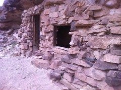
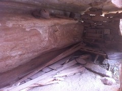
The coolest thing to me was the hinges on the door. They were very different from one other and neither appeared to have been replaced. They were just always like that. I guess that's all he could get a hold of. Beamer apparently used his cabin as a base for mining and farming. Looking around, you could see rock walls he'd built to form farming terraces though they were completely backfilled now. Ultimately the mine didn't pan out, the farm failed and he abandoned the cabin to history.
What I wanted to know though, was how he got the product of his mining out. Did he carry it out on his back? Did he have a mule or a donkey? Did that animal really negotiate that trail we walked in on or was it cleaner 150 years ago? I could easily imagine some of those shelves being wider. Did he stockpile it somewhere and take it up Tanner in bulk? Details, details. I want to know!
The Beamer Cabin was actually a little bit past the end of the Grand Canyon proper, along the Little Colorado which, because of all the travertine dissolved in it, glowed a brilliant blue.
The travertine came out of solution on the little sandbars too and formed little shelves with pools on top. I took some photos but they didn't turn out well.
A "trail" appeared to continue on past the cabin but I believe the land beyond belongs to the Navajo and you need a permit to hike there. I'd actually like to come back sometime and hike down from further up the Little Colorado. It's a beautiful river.
We headed back, past the confluence...
...back into the Grand Canyon itself and back along the same arduous trail we'd pushed down the day before, stopping only briefly to find the spot where United Flight 718 went down.
I was able to keep up for a while, maybe for 4 or 5 miles and it didn't seem to take nearly as long to get past the buttes. I'd gotten some recovery after all.
We passed a rattlesnake, waiting patiently for a mouse.
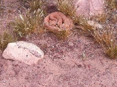
It was pink in real life, I'm not sure why it looks so orange in the photo.
Rattlesnakes have evil-looking eyes.
We'd actually seen a satisfying amount of wildlife so far. On the drive in we'd seen a herd of mule deer. On the way out on Beamer, hundreds of lizards fled our approach. One was pretty big but too far away to identify. I'd seen what was probably an Albert Squirrel earlier that day, but again, it was too far away to positively identify. We saw fish in the river, and of course, there were ravens. Dozens of ravens, soaring like vultures, squawking their weird call. They seem to be huge, fat, crows until you hear them speak. "Nevermore"? I don't know. Poe might have been really high when he wrote that.
Eventually we made it back to Tanner Beach and again I ate quick.
The trail west of Tanner Beach is the Escalante Route. Our plan was to take it west to the end and pick up the Tonto Trail. If we felt bad, we'd head up the Grandview Trail and catch the bus back to the lodge. If we felt better, we'd continue on to either South Kaibab or Bright Angel and just walk back to the lodge. If we felt great, we'd continue on to the Hermit Trail, take that up and again catch the bus back to the lodge. That was the preferred plan and in theory, we'd packed enough food for that.
The Escalante Route has a few difficult sections though. There was a 30 foot wall, an extended descent on a loose pile of rock and a pass through a slot canyon. Above all else, we needed to get through the slot canyon (Seventyfive Mile Canyon) before the rain hit. Per the forecast, we still had a day and a half to do that and it was about 9 miles away. It should be possible.
The Escalante Route was a lot easier than Beamer, at least at first. As soon as we got off of the beach, it became glorious bench-cut singletrack.
The views of the Colorado were nice too...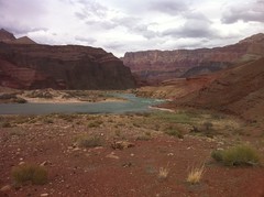
... at least in retrospect. At the time, I was way more focused on getting down the trail ahead of me.

"Dude you crack me up. You're in one of the most amazing places in the world but every time I look back you've got your head down and you look like you're in a bad mood. Why are you in such a bad mood?"
Actually he might have asked me that on Beamer. It kind of runs together now. I wasn't in a bad mood per-se, I was just pushing too hard to look around and enjoy the scenery. I don't remember what I said. Something along those lines.
I'd been falling behind again.
At about 4PM we made it to Cardenas Creek and the Unkar Rapids. We needed to go another 6 miles but the aforementioned obstacles lay ahead and there was no way we could do it in the 3 hours we had left before dark. Clouds were rolling in, the wind was blasting and it was cooling down. If we kept going, where else could we stop? Nothing really looked good. There were high ridges and dry creeks ahead of us. It didn't matter to me, we could both carry about 5 liters of water if we needed to. John decided. We'd camp there, get extra rest and push through to Tonto the next day.
Unless the rain came early, we'd have no problem. The clouds that were moving in were looking pretty dark though. Maybe the rain would come early.
At first we set up on a little ridge by the edge of the creek but the wind picked up and we were inundated with sand. John found a little grove of some kind of weird tree to the east though. The trees grew in rings, there was grass, and it was still up off of the delta a bit. It looked perfect and we moved there. The trees didn't block the wind as much as we'd hoped but it was way better than up on that ridge and with the grass, the sandening was minimal.
I wish I knew what kind of trees they were. They had no leaves, they looked dead, and they had big branches that drooped down to the ground before lifting back up again, like a miniature Live Oak. Cool trees. I'll have to look them up.
One thing that I had done right so far was food.
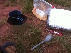
I'd packed around 1800 calories per day. John suggested Met RX Big 100 bars for breakfast and they worked really well. I'd packed potatoes for lunch and pasta for dinner. To snack on - beef jerky and a mix of dried cranberries, blueberries, cherries and Jolly Ranchers. I also brought enough Gatorade powder for about 2 liters of that each day, and a package of hot-chocolate, but I never really had a chance to make the hot chocolate. Each day's food fit in a quart-sized ziplock and I wrote the date on the outside to keep them organized. It packed well and for the first time yet on one of these trips, I felt like I had enough food.
I used an alcohol stove - a cat food can with a bunch of holes poked in it, filled with Heet (the yellow bottle, not the red). I'd last used one of those at ORAMM last year to cook up the E's coffee. They work really well and they weigh nothing.
They say a watched pot never boils.
But that didn't stop me from watching. I'd boil water in a little Ti cup, pour it into a quart bag full of either pasta or potatoes and slip that into a sleeve made out of mylar-coated bubble wrap. I can't take credit for the setup though. John suggested the stove and the sleeve and it worked well. The potatoes were ready as soon as the water hit them but the pasta had to sit for about 15 minutes.
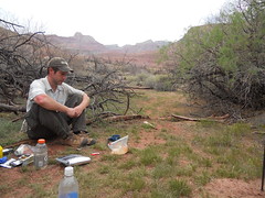
We sat in a little ring of trees for a couple of hours, ate, drank, rested, recharged, studied the map and talked about all kinds of funny stuff. A campfire would have made it perfect, but we didn't need one and besides, no campfires are allowed below the rim anyway. We went to bed a little before dark.
That night the wind blew and blew. I put my pack next to my face to keep the sand off and it was sufficient. My bag just got a light dusting and I slept for a few hours.
Some time later it began to rain. The rain was light at first. I was fast-flying my Seedhouse tent but except for a single drip strategically placed over my face it kept me dry. John was under a tarp and I could hear him semi-snoring so I figured he was good too. I just moved my face to the left and fell asleep again.
Some time later the rain picked up, but more importantly the wind picked up and changed direction. All day it had been blowing up the main canyon from the west and for some reason bending around into the trees from the north. Now it was blowing down Cardeans, from the south, hard. John had set his tarp up slanting to the north and now that the wind was coming from exactly the other direction, the rain was getting driven directly under it. I woke up to some savage rustling and I could see his light spinning around wildly.
"You ok?"
"Yeah, I'm getting hammered but I'm fixing it."
"Ok, let me know if you need anything..."
A few minutes later his light went out and he settled down. Apparently he'd fixed whatever problem he'd had, or at least managed it.
The tie-outs down by my feet had popped off of their stakes. I often have that problem with this tent. At first I just pulled my feet in but eventually I scooted most of the way into the vestibule and stretched back out. There was a thin layer of water on top of my bag and I wondered it it would be a problem or not. Its a down bag and enough water can render it useless. The tent isn't totally waterproof and eventually water seeps through and runs down along the inside. With the wind, the sides were getting blown against the bag, especially down by my feet. Before long though, I guess from body heat and because the sides couldn't touch me any more, my bag was dry. Despite the rain, I fell asleep again.
At first light, John woke me up. It was cold and still raining but the wind had slacked substantially. He'd been up most of the night trying to stay dry and thinking about what we should do. The rain had come early. If there was rain in the Canyon, there would be snow on the rim. The storm was supposed to last for two days. It was too bad that we hadn't made it to Seventyfive Mile Canyon already because it could be flooded. It might not be, but even it wasn't, the Grandview Trail would be treacherous, if passable at all. If we pushed on to Seventyfive Mile and only then discovered that we had to go back, the Tanner Trail might be a wreck by the time we got back. We might have been able to push on to Seventyfive Mile, wait it out then push on to South Kaibab or even further but the safest option was to try and beat the weather back to Tanner and exit there.
No buses run to the top of Tanner, but it was likely that we'd run into a cab dropping someone off or some tourists taking in the view or a snowplow that could radio in for a cab. Worst case we could text Kristy to call a cab to pick us up. Absolute worst-possible case, we could just start walking back on the road. It was 20 miles but we had plenty of food and with all the snow, plenty of water.
We headed back.
The storm was still coming in. This same view was clear and pretty the day before.
This time, John let me lead and just followed whatever at pace I set. I went as fast as I could sustain and for the first time, enjoyed the Canyon. I could even look around and take in the sights. The short, steep descents still punished my knees, mainly my left knee now for some reason, but otherwise it was great. Even the beach sand had hardened up a bit.
Oddly, the weather had cleared somewhat too. It wasn't raining any more, or all that windy. Ahead of us, in the direction of Tanner Creek, there was blue sky. It still looked gloomy to the west but not all that bad. John second guessed himself for a minute but only for a minute. The weather can change quickly and it's usually better to stay on plan unless something significant happens to prevent it. We kept going.
At Tanner Beach we tanked up for the ascent and got to it directly. It was a relief. I still felt good and climbing didn't put much strain on anything that hurt. How often is it that you're relieved that the rest of the hike is a 5000 foot climb?
Again, I went as fast as I could sustain and really enjoyed the climb.
There's a ribbon of barely-even-singletrack leading up from the bottom along the side of a decomposed sandstone ridge. Just from the rain the night before and lack of traffic that day, there were several stretches where the backslope had already begun to slump down and obscure the trail. Most trails fight erosion. This trail had to fight deposition. I'd bet that it if went unused for a year you'd have to just wear in a brand new line. I'd wondered earlier if the Beamer Trail had been cleaner in antiquity. I'd bet that it had. It appeared that given a little rain, the Canyon changes quickly. Not only the trails, but the slopes and the shelves and cliffs and piles of talus and everything else. Maybe that's the simple secret of the Canyon's grandeur - it erodes quickly.
About a third of the way up we ran into a small group in a pair of tents. They'd come down the night before and were planning on spending a few days in that immediate area. They'd hike back out after the storm.
About two thirds of the way up we got a good look at where we would have tried to get out had we kept going.
It was getting absolutely hammered with snow. Neither of us had been on Grandview before but the route descriptions make specific mention of highly exposed singletrack - ie. a narrow trail meandering along the edge of a several-hundred foot drop. No big deal in good weather, but snow could do two things - blend in the backslope, completely obscuring the trail, or create a shelf that could lead you out over the drop and give way with one bad step. After days of compaction, the likelyhood of the latter is slim, but with fresh powder, it can happen. John had ran into both of those problems before, I think in Rainier and Teton. After seeing the weather out that way, we both felt better about not pursuing that route.
As it was, we still needed to get up through the snow that had settled in above us, but it didn't look too bad.
In fact, it turned out to be straightforward. Someone else had already been up that way today. The transition layer between wet, ice and snow required some attention but when we got into the powder it was grippy and there were big footprints to step into.
About halfway up we ran into the responsible parties. They turned out to be the same group we'd run into on Beamer a few days earlier. At first they didn't recognize us but then they saw John's shoes.
"Oh! Mr. Red Shoes!"
And then they remembered. "The Runners" they had called us, presumably because John was hiking in red running shoes. We talked with them for a few minutes and they were more than happy to give us a ride back to the lodge. They had a bad-ass VW van parked up at the lot and plenty of extra room.
Awesome.
The snow above them was deep and fresh and I made fairly slow progress up the first switchback. Looking back I could see that their lead guy (Rodger was his name) was following closely, so I suggested that he break trail with his crampons and he was more than happy to do so. He was a horse and he led us all the way out.
The weather changed multiple times before we got to the top. We'd have blue skies and sun...
...and then ten minutes later, wind and driving snow.
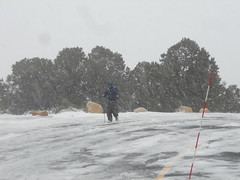
The push into the wind across the parking lot was like one final kick in the face but the glowing luxury of the waiting van was great motivation.
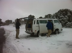
The rest of the group arrived within half an hour and after pushing the van out of the snow we were on our way back to the lodge. As much as we wanted to hang out and eat with the crew that had saved us, we had to coordinate lodging as quickly as possible. Fortunately there were several cancellations and we managed it.
We settled into our room, dried out our various articles, showered... Ahh, the pleasures of civilization we take for granted every day.
The sky above us was blue and pretty but on the North Rim, the storm was still raging.

That night and the next morning we got another foot of snow. The weather changes that quickly.
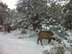
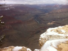
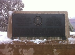
The next day we did the tourist thing. We ate like 3 meals at the bar, bought shirts at the gift shop, took the tour bus around, saw elk...
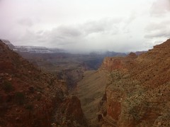
...took in a few different views of the Canyon...
...saw some historical stuff...
...and watched the rest of the tourists. It seemed that everyone visiting the Canyon brings a new backpack and a new pair of boots or hiking shoes, independent of what else they're wearing or what they plan on doing. Hiking boots and a new backpack go with tee-shirts and jeans, slacks and button up shirts and puffy sweaters, leather skirts and pantyhose.
We watched a couple of movies too - one was informational and explained the geography of the Canyon among other things, but the other was made by the Kolb Brothers who lived for years in a house at the edge of the Canyon at the top of the Bright Angel Trail, or the Bright Angel Toll Road as it was at the time. They took photos of mule riders on their way down and developed them before the riders returned. It reminded me of those photos they take on the roller coaster that you can buy at the gift shop on the way out. They may have even been the pioneers of that idea. They explored the canyon end-to-end, found all kinds of crazy stuff, ran the Colorado from Wyoming to Mexico in wooden boats and captured it all on video and film.
The only thing we didn't get to see was Desert View - this big awesome tower about 5 miles out past Tanner Creek at the edge of the Canyon. While we were hiking, we could always see it unless we were way up in some side canyon. It was like the Eye of Sauron: unblinking, always watching.
Always watching.
The tourist stuff gets old after a day or so. It's one thing to see the Canyon, but it's quite another to feel it and that's what we'd really come there to do. I was wrecked though and I think once you're out, it's hard to get motivated to go back down in. We ended up moving our flight up a day and a half and just bailing out as soon as we could.
So, what worked? Everything that usually works for me, plus a few new things - alcohol stoves, quart-bag food plans and mylar pouch ovens. My tent was a good choice but I've got to figure out some way to stake out those foot ties better.
What didn't work?
One-liter Gatorade bottles for sure. I ditched the Nalgene bottles in favor of recycled Gatorade bottles at the last minute. The bottles worked in the sense that they held water and I could drink while walking but they have structure to them and they get stuck in the pockets and it's a serious pain to get them out. My brother was using taller, narrower and smoother Smart Water bottles. They appeared to be a much better choice.
My clothing sort-of worked. I was never hot or cold and the temps varied from the teens to the low nineties. I did manage to rip open one of my pants pockets and my shirt exploded.
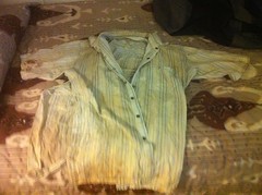
Kirk actually suggested that I burn it two trips ago. It might now be time. It ripped all the way up the right side. There are permanent stains all over it too, including some good blood stains on the sleeves now from a series of nosebleeds I got down there. John said that I should tell everybody that they were from wrestling a puma.
My shoes sort-of worked. I wore them completely out. They were kind-of close to worn out when I started but now the left side of the left heel is worn all the way through the rubber and into the foam. It's actually uncomfortable to walk in. Maybe I'll try some of the shoes John was wearing. They seemed to work pretty well for him.
My pack only sort-of worked too. It was light and comfortable and it held everything I needed it to hold but I managed to pop the strap you can hang it from and snag it like my pants and tear part of one of the pockets. The chest strap had already popped in Shining Rock. It might be time for a new pack.
What a trip. It was worth doing and I saw some cool stuff, but except for that third day, heading out, I'd have to put it in the work/suffering column rather than the fun column. I'll definitely go back though. Maybe I'll go back by myself, or maybe just with a less ambitious schedule.
Either way, it's going to be a while. I've had enough of the Canyon for now.