Monday, December 18, 2017

East Jones Creek

Lately, I've been motivated to finally explore some super, super old dotted lines on my map, dating back 10 years or more. When I first got serious about exploring the Cherokee National Forest, I started with the Blue Ridge WMA. You might think I'd have wrung it out before moving on to the rest of the forest, but no, it still holds some secrets. At least to me.

This past Saturday, I headed up East Jones Creek. I have no idea what the true name of the creek is, but if you follow Jones creek upstream from the general Bull Mountain area, right before it starts to climb uphill in earnest, it's the last fork that splits off to the north, and there's an old road that follows it. It's the next road up 877, past Silver Dollar, if that means anything, to anybody.

I'd been up that road before, but always hung a right toward Silver Dollar. There's a fork to the left too. It's a fork less traveled, and a very old hunting map alleges that it runs way up along the creek. My experience with trails from that map has been that they tend to exist, and tend to continue beyond the limit shown on the map. Saturday I found out.

On the way up I stopped at a gas station in Tate, grabbed some Gatorade and snacks, and began paying for them. While waiting for my card to process, I noticed the lady behind the counter stare down into some snack bag and mutter: "Damn you, Shannon." As her eyes rolled up to meet mine, the look on her face seemed to ask whether or not she'd said that out loud. I was intrigued, to say the least. "Yeah?" She smiled and aimed the bag in my direction. "These don't look like they'd be good, do they?" I wasn't sure. The marketing on the package indicated that it contained popcorn, covered in some sugary coating intended to simulate the flavor of birthday cake. It didn't immediately strike me as good. Caramel, yes. Salt, yes. Birthday cake? Who would even think of that? Too foreign. "Not really. Are they?" She didn't answer directly. Instead, she just handed me one. Man, it was good. Way better than I expected. That was my response to her. Something like that. I now understood. Someone named Shannon had introduced her to these candies, she had gotten to like them, and though she might know that they aren't good for her, she was definitely going to consume the entire bag. I had finished my transaction during the exchange, but had I not already paid, I'd have purchased a bag for myself. Give them a try, if you get a chance. They are way, way better than you'd think they'd be. That is, of course, if you can afford to eat them. She must have felt that she couldn't. Man, I've been there, especially around the holidays. So, to offer support, I repeated her words as I left the store: "Damn you, Shannon!"

I thought about the snack several times later that day, and seriously considered stopping on the way home to get some.

But, back to the Adventure...

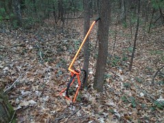
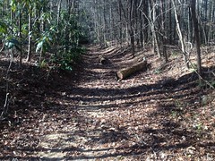
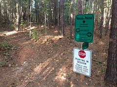
I parked on FS877 and headed up the old road, which was generally clear. It had been decommissioned with some marginally effective Kelly Humps sometime very recently. There was a bit of light deadfall here and there, but aside from that I could have easily driven it.

FS877 Food Plot Road

A ways up, I suddenly realized my map was no longer in my hand.

Dangit! That's becoming a regular occurrence!

This time, I went back for it, and found it lying in the dead middle of the road, only a hundred yards back or so.

Dropped My Map

The heck? How do I keep doing this?

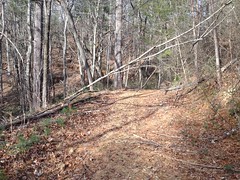
I found the turnoff that I usually took, way back, and stayed left this time.

That fork got decidedly less traffic, but it was still pretty wide open. No real overgrowth, just a bit more deadfall.

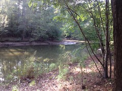
Off to my left, I could hear some serious rushing. At the time I wasn't sure if it was just the wind through the trees, or water. It was quite breezy, but a quick look at the map made me think waterfall. The geography is just right for a pretty good falls on West Jones proper. I never got close enough to see it though, so I'll have to make another trip out there for that specific purpose.

I did cross the creek itself though.

East Jones Creek

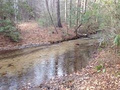
That's quite a current. A falls downstream of that could be pretty impressive.

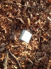
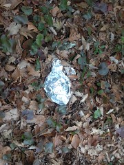
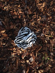
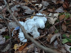
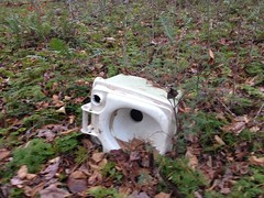
Just uphill from the crossing, the map shows a weird little P-shaped side trail off to the left of the main trail. There was an old campsite there, but it looked like it had last been used a very long time ago.

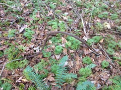
It had been popular though, as evidenced by the trash that remained.

Old Campsite Trash More Old Campsite Trash

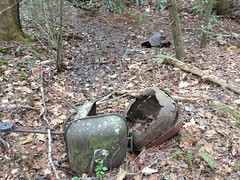
They'd made some good progress, but I wondered how long it would be before those old grills rusted into absolutely nothing at all.

The P-shaped side trail looked really overgrown, so I didn't give it much of a chance, but resolved to save it for another trip too.

A bit further up I found a much cleaner side road that ran straight down to the creek and looked like it might have once forded it. There was no discernible evidence of anything continuing on the other side though. There was a large, level area over there, but no road, no trail, no nothing.

Back toward the main road, I noticed two piles of organized rocks.

Organized Rocks Near East Jones Creek More Organized Rocks Near East Jones Creek

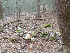
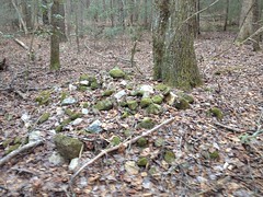
The rock looked like it might have come from the creek.

Two collapsed chimneys came to mind. It would have been a good place for a house. Hard to say though. I may have been letting my imagination get away from me.

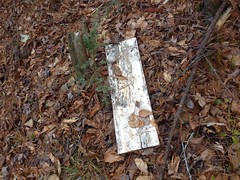
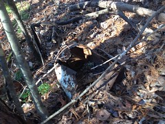
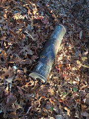
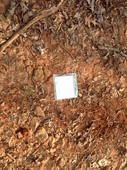
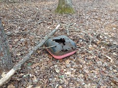
Further up I found this cinder block in another small clearing.

Cinder Block Near East Jones Creek

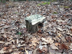
Could it have been the location of another structure? It would have been a decent place for one.

Maybe.

Or maybe someone just dumped it up there with some other trash.

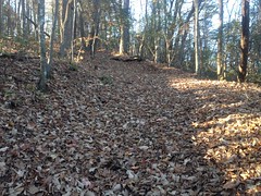
Further up, the trail got a little more overgrown, and a little less distinct, but it was still pretty easy to follow.

Old East Jones Creek Road

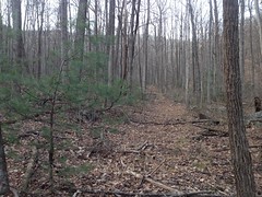
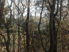
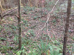
As it ascended Ball Mountain, there were numerous spurs leading up the various spines and draws. Some of them rejoined the main road, and I wondered if they may have been former routes rather than just spurs.

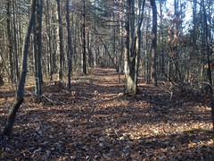
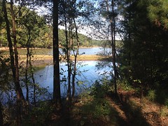
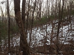
It's pretty rocky up there, and the crisscrossing hills are quite striking this time of year.

Rocks In Upper East Jones Creek Cove

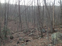
Sadly, these photos don't really do it justice.

At a point, I reached a juncture that was terribly overgrown with briars, and couldn't discern the trail ahead through them. It turned out later, that was the end-point prescribed on the old map, but the trail did lead on, it was just very difficult to see.

I only discovered this later, after following some side trails and eventually circling back around.

One such trail led to the base of a tall, but shallow sliding falls on East Jones Creek proper.

East Jones Creek Sliding Falls

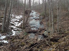
Again, the photo doesn't do it justice. It's like 5 or 6 times as tall as it looks here.

On the other hand, calling it a "falls" might be giving it a bit more credit than it's due. Sure, water flows down it, but I'll bet it doesn't flow down it year round. We just had a significant snow melt, and though the surface was evenly wet, there wasn't much discernible movement. I'm not sure what to call such a thing though, so until a term is invented, I'll call it a shallow sliding falls.

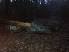
This big rock nearby marked the end of the old road.

Big Rock East Jones Creek Sliding Falls

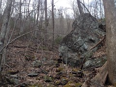
The road led directly to it and stopped right there.

No further.

I pushed on though, off trail, in a big circle until I picked up another branch of the road, and followed it until it teed into the creek and ended as well.

I imagined that the road might once have crossed the creek, and headed straight up the fall line on the other side. It wasn't shallow, but it wasn't materially steeper than the road itself. There was no obvious evidence of that though. No obvious break in the canopy. No dent in the ground. For as far up the mountain as the road had pushed, I had begun to expect it would eventually push over the shoulder. If it did somewhere though, it didn't there.

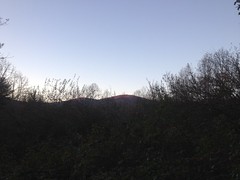
Thinking maybe I just couldn't discern the true route, I walked in a big circle, looking for clues. I didn't find anything, but from that vantage, I did enjoy the snow-covered face of the next draw over.

Snowy Hillside

I could also see Little Sal Ridge to the east.

Little Sal Mountain Ridge

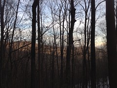
I suppose the knob on the left is the one that towers over Winding Stair Gap. The one with the food plot on top. At the base of the knob on the right is P.R. Gap, where Silver Dollar descends to the west and Gold Coin ascends to the east. I imagine that Little Sal Mountain is out-of-frame to the right. I didn't pull out the compass to be sure though, so I could be wrong.

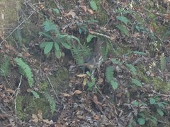
I probably stood there 5 or 10 minutes just taking it in. Sometime during that, some movement above me to the west caught my eye. I saw some four-legged animal trotting downhill, in the snow, toward the creek. Abruptly, it turned right about 150 degrees and bounded away as fast as it had come. I had at first thought coyote, but when it turned, it looked much more distinctly like a bobcat. Feline features, and no visible tail, in particular.

My brother had seen one, once, while riding Bull Mountain proper. I'd seen them in the zoo, at the Aware Animal Sanctuary, and dead on the highway, but I'd never seen one alive in the wild.

Yeah!

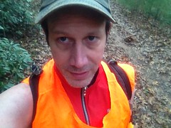
It didn't occur to me until a bit later that it might have seen me as well. I was black from head to toe, except for my orange vest. Sources generally say that most animals can't distinguish blaze orange the way we can, but the rest of my outfit may well have stood out against the otherwise brown background. Hunters wear camo, and not black, for a reason.

On the way back down, I discovered another well-traveled spur leading up from the briar patch along another spine, but just didn't have the time to investigate. It too, would have to wait. As it was, I ended up back at the truck well after dark and had to move with a purpose to get home in time.

In time for what?

Star Wars!

It was opening weekend for The Last Jedi and I managed to get home in time to take Kathryn and Iz to the 8:30 showing.

What a day! Two Adventures. One real-world and one cinematic.

Sunday, December 17, 2017

Snowpocalypse '17

This year's snowpocalypse was a little anticlimactic. I think the city of Atlanta declared a state of emergency, but aside from few power outages, the emergency generally failed to materialize. The kids did get Monday off of school though!

The neighborhood got a nice dusting.

Snowy Neighborhood

Enough to make a decent snowman.

Jerome Bonhomme

Sophie named it Jerome Bonhomme.

But, it started warming up as quickly as it had cooled down, and I didn't even manage to get in my usual urban mountain bike ride.

I guess it's still earlyish in the season though. Who knows? We could get another good snow in January or February.

Monday, December 4, 2017

Bull Mountain Ridge

I guess that's a decent way to describe where I went last weekend.

It wasn't my original objective though. I had one promising-looking dotted line left on my map, leading away from Nimblewill Gap Road, so I went to check it out first. It clearly used to get vehicular traffic, and the FS apparently closed it with berms and downed trees. It was still passable on foot, but after the initial climb up to the ridge, it became densely overgrown and I didn't pursue it further.

My secondary objective for the day was further exploration of the network that I'd discovered between the Bull Mountain Trail and the trail leading over to the Black Mountain shelter.

So, once again I found myself on Muffler Ridge, heading north. This time, it was all very familiar.

I managed to get a marginally acceptable photo of Bull Mountain proper, from the ridge.

Bull Mountain from Muffler Ridge

And I realized looking at it that the other photo I'd taken from that privet field a few weeks earlier must have been another knob on the ridge, and not Bull Mountain proper.

About halfway up, I saw something whitish lying in the ground ahead of me...

Ha!

It was the map I'd lost several weeks earlier!

My Lost Map

I'd forgotten entirely about it, but I was glad to be able to pick it back up.

I followed the old road up the ridge, hung a left toward Black Mountain, and followed the modernish cut below that ridge until it eventually dove down towards the Bull Mountain Trail proper.

The old roads up there are much, much easier to follow in winter. It's like night and day. The brush and deadfall still shredded my ankles a bit, but it was a million times easier to discern the old roads themselves, and I didn't miss getting little bits of everything stuck to me, constantly. It's funny, every year I forget about what it's like in whatever season I'm not in, and then I'm surprised by how it is when that season actually comes along. You'd think I'd learn...

There is one very distinct spur off of the old road that leads up from Bull. In fact, if you were coming up the old road, from Bull, you would find that it is relatively clear until it hits that spur, then above that spur, it's fairly overgrown. It would seem that it was used, for some time, to access that spur, in particular.

The spur itself is unremarkable - some random bench cut that runs out to some little creek and ends abruptly at it.

But right below the end of the road, someone had clearly hollowed out the backslope, just enough to level the ground in maybe an 8-foot diameter circle. Inside of the circle there were the remains of some odd, also-circular, stacked stone construction.

Odd Stone Construction

It doesn't look like much in the photo, but in real life, it really looks constructed.

I've seen plenty of old collapsed chimneys in the woods, but this didn't look like one of those. It was super-close to the creek too. Way too close to build a house, and the backslope was really steep anyway, and not otherwise leveled.

It's not impossible that there was a house built on the road itself, that extended out into the space below it, and this was a footing for it. But its proximity to the creek made that seem unlikely. If it was a mill of some kind, then they sure picked a tiny little creek to feed it, and a terribly obscure location.

Between the obscure location, comparatively clear access, proximity to the small creek, and size of the construction, it seemed most likely to have been related to moonshining, but I don't know enough about how old stills to be confident in that. I'll have to do some research.

Whatever it was, it was slightly intriguing, and I hoped it wasn't just some natural formation that I let my imagination misread.

Eventually I made it down to the Bull Mountain Trail itself and it seemed weird to be hiking it, that far up, rather than riding.

I checked out a few side trails that I'd noticed before, but all were very overgrown, and none went very far.

I also noticed that Stan had recently cut out several downed trees. Thanks Stan!

Of course, I found a mylar balloon.

Balloon off of Bull Mountain Trail

But, I also found this distance-measuring thingie, just above the old truck.

Distance Thingie

The ticker read 01000.

I'll have to ask Debbie about it at the next work party. Maybe she knows why it's there.

From there, I pushed back over to Muffler Ridge and descended back to the car.

It wasn't officially dark yet, but it was getting there. The sky was beautiful to the west, and the moon was high and bright in the east. Except for constantly catching my ankles on invisible sticks, I really enjoyed the hike back. It had been a while since I'd been out in the dark.

One of the coolest things wasn't what I saw though, but what I heard.

I first noticed a howl, about the pitch of a tornado siren, behind me in the general direction of Springer Mountain. It sounded like a man though, not like any coyote or owl, or anything else I'm accustomed to hearing. I heard it again later though, and it was distinctly canine, with little yips and barks before and after it. I also heard several different owls, though I don't know them well enough to distinguish them by their calls. I heard the howl many more times, and it always came from the same direction. At first I wondered if some guy just had a dog up on Springer Mountain, but it really seemed much closer than that. Could just be some dog running around in the woods, or maybe I just don't know what a coyote really sounds like and it was one of them. Anyway, it was intriguing, and it's definitely something else that I need to research.

I eventually made it back to my truck, which I'd parked below the privet field, off of 28D. On the way out, I managed to bottom it out once in a rut. Man, the ruts on that road...

I tried eating at Brooklyn Joe's in Canton, which I eat at regularly during the work week, when I'm in Canton, but they were busy, and Georgia had just won the SEC Championship, and everyone was all excited, and after 10 minutes of waiting with no server even glancing in my direction, I reasoned that even if I managed to order in the next minute, it would still be less time between then and eating if I left, and went to Chipotle. So, that's what I did. I'll be back to Brooklyn Joe's, but at the time, I was just so unbelievably hungry. Chipotle was the better choice.

Nimblewill Gap

A few weeks back, hot off, a recent excursion to the general Nimblewill area, I was primed for more of the same. Ages ago, on the way to Bearden Falls, I'd seen a little spur off to the left that looked intriguing, but that I hadn't followed at the time. It had lain dormant on my map forever, and though I'd toyed with the idea of checking it out last time, I'd run out of daylight.

Not so this time.

On the drive in I ran across some manner of pheasant, which seemed completely ambivalent to my presence. Ambivalent enough that I was able to take a decent photo of it.

Some Manner of Pheasant

Decent, that is, except for being shot through the car window.

I parked off of old FS28E. I call it that. It was originally marked FS28C in the field, but there's actually another FS28C over by Turner Creek. The USFS GIS data calls is FS28E. But, no matter what it used to be, it's neither any more because the old sign has been pulled up, and it's been blocked off by Harambe Rock...

Harambe Rock

...and Marcy Rock...

Marcy Rock

...and a few other rocks.

It's still very open and clear though.

Old FS28E

And it seems to get a good bit of traffic.

At the first creek crossing, it looked like people generally don't realize that they need to cross the creek, but then eventually figure it out. There were several tangles of deadfall between there and the next crossing too, with little route-arounds for each of them.

On either side of the second crossing were very large piles of dirt. They looked like mine tailings, but it wasn't clear where they might have been dug from. Gold would be the obvious thing to have been mined in the area, but there were no other indications of any such operation, nor had I ever read that gold was mined in that particular area. I'd seen similar piles along Alec Branch to the north, which I eventually decided were remnants of a logging operation, but upon closer inspection, these piles weren't as similar as I thought. They looked more like the slag heaps surrounding those furnaces in Pinelog. But, there's no iron in Nimblewill.

I was puzzled and decided to take some photos, only to discover that my phone had died.

Dangit! No more photos of this particular adventure.

I pushed up the trail, which was also quite well traveled. I passed some old campsites, and a large collection of "organized rocks". The rocks were piled up neatly. Lots of individual piles. It didn't look natural. I've seen similar collections before. Farmers clear their fields that way sometimes. Native American cemeteries have a similar look. I could stretch my imagination and think of a way it could have occurred naturally, but it seemed unlikely.

Wish I could have taken some photos.

Further up the trail branched and split and rejoined several times, and there were various little spurs.

It looked a lot like the network along Alec Branch. Routes, older routes, and even older routes, all eventually leading to Nimblewill Gap. It looked like modern FS28-2 is just the most recent revision of the same. No doubt logging was involved at some point, but it was tough to to discern whether it was the original purpose of the roads or not. I didn't see any evidence of habitation back in there. I did find a small sliding falls, but nothing spectacular. I did wish my phone wasn't dead though. It might have been worth a photo.

And, that was about it. Not a spectacular day. I did push a little harder and spend more time out there than usual, but it wasn't too tough.

There was only one more thing that is moderately worth noting.... During my previous excursion, I'd noticed what appeared to be a really well established campsite, and wondered if it was occupied, or whether someone had just dumped some stuff. Well, it was definitely occupied. On the way in, I noticed a family milling around the site, and truck parked nearby with two flags flying out of the bed. At the time, I was like: "Oh, ok, someone really is camping there." The truck was kind-of distinctive though, between the paint job and the flags. On the way out I noticed that it wasn't there any more, and figured they must have run to the store or something. Then, on the drive back, I stopped at a gas station that I often stop at halfway between Tate and Dawsonville, and I saw the same truck parked in the lot. It's not the nearest gas station, or if it is, then there's some back-way of getting to it that I'm not aware of.

It reminded me a little of Vonnie and his family. They used to drive up to North Georgia each summer and spend a week or two camped somewhere. They'd hike, fish, and ride, but also they'd visit the local towns and do all the regular stuff - see a movie, check out the restaurants... I remember him telling me that he would even take his daughter to the local libraries to read.

I know a lot of retirees do that kind of thing - RV'ing around the US. They were a young family though, my age. I always envied them a bit, that they could do that together.

Anyway, that's all. Not much else to that particular adventure. Doesn't even get a capital A.

Seems like I ate at Canyon Burger that evening. Grilled chicken with bacon and swiss on it.

Yeah, that's right! Man, now I want one of those for dinner tonight...

Sunday, December 3, 2017

Chester Creek

There's this road off of Nimblewill Gap Road, across from FS28D, that looks very road-like, but doesn't appear on any map. I've seen it for years, but never had the inclination to see what was out at the end of it. That changed a few weeks ago though. I'd explored the general area around FS28D, but not had time to check out that particular road. Whenever that happens, I tend to want to get right back out there.

Such was the case.

I drove up to Nimblewill and parked along the road near my objective. A family was camping in the site at the near end of FS28D, and a gentleman came out to greet me as I got ready to go. I was wearing my orange vest, and I imagine he might have been curious about what I'd be doing, and more precisely whether I'd be doing it too close to him and his family. His expression and demeanor became abruptly friendly as he got closer, perhaps as he noticed I was unarmed, and we had a very friendly exchange. He and his family were up there for the 4th year in a row, at their favorite spot, for what was becoming a post-thanksgiving camping tradition. He hadn't seen anyone else hunting nearby all day, so I wasn't likely to bother anyone traipsing around off trail, or them, for that matter.

We wished each other well. He headed off back to camp and I headed off in the opposite direction.

Chester Creek turned out to be the name of the creek that runs up along the road. The road itself had a number of significant mud holes, which appeared to have been well enjoyed by the local 4wd enthusiasts. Other than that, it was a fairly clean and well-maintained road, less rutted even than FS28D. It wasn't immediately clear why it was omitted from maps.

On the way out I found what might have been a former route, and a couple of little side trails, all very overgrown. I also found this balloon between the road and the creek.

Balloon on Chester Creek

Eventually I reached this non-FS-looking gate and accompanying signage.

Gate at Chester Creek Inholding

Ahhh, an inholding. Now it all made sense.

No idea what the weird PVC-pipe thing is to the left of the gate. I studied it for a few minutes but couldn't make sense of it.

I noticed the remains of a signpost to the right, and found the old sign that was once attached to it nearby.

Old Sign at Chester Creek Inholding

Whatever it once said, it no longer did.

I imagined it may have said something like: "No Trespassing. Violators will be shot. Survivors will be shot again." Ironically, between then and now, I saw a similar notice at a house I was picking up some theater props from.

On the way back, I checked out the former route and side trail.

Near the east end of the former route, I noticed this crater.

Chester Creek Crater

Which, of course, looks like nothing in the photo, as is generally the case with holes in the ground.

I'd seen a similar construction off of Randa Creek, and another one off of Jones Creek below the Horserange. It was clearly constructed. It looked like part of it was dug out of the sidehill, and that part was used to form a levee around the rest of it.

I've seen a few of these now, but their purpose is still elusive. I haven't yet seen a similar construction in modern use.

I found this old metal bucket off of the side trail, but it was otherwise unremarkable.

Old Bucket

So, that was it for Chester Creek proper, but there were several little dotted lines on my map nearby, so I hiked back down the main road to the east a bit, to check out another long-neglected side trail.

It was a really messy old road - braided where it teed into the main road, and went straight up the draw as soon the second it got up above the little stream. It was relatively overgrown, except for a clear path cut through it, which soon became a well defined sidehill leading up to the ridge.

At the ridge, this little stuffed pony was lying next to the trail.

Stuffed Pony

It's not a good idea to go climbing over ridges during deer season, unless you really know what you're going to find on the other side. For all I knew, someone had parked at the foot of that draw, hauled a tree stand a mile uphill, in the dark, and had been sitting there freezing for the past 6 hours. I didn't want to ruin someone's day, or my own, so I decided to turn back. Later I discovered that the ridge was the border of another inholding, and it was private property on the other side. The border lacked the typical red blazes, but at least it explained the trail.

After that, I headed back to the truck and drove up the road a ways.

I passed an elaborate campsite on the way up. It looked like the occupants were planning on being there a while, but there were no vehicles or people nearby, and the fire looked long dead. I wondered if they'd just abandoned a bunch of gear. I'd seen something like that in the Upper Chattahoochee once - thought it was an active campsite, but it was just 2 tents packed with garbage.

Up the road, I explored a couple of side trails. One had an abandoned camp toilet lying out near the end of it.

Abandoned Camp Toilet

And an even older logging cable just below it.

Cable

The others just went this way and that before ending randomly.

It was getting dark, and I wanted to see if the road to Bearden Falls was still open. Billy and I had recently visited Cochran's Falls, and discovered that the road had been blocked. It occurred to me that the same may have been done at Bearden Creek.

Indeed, it had!

Bearden Creek Road Blocked

Nice.

For the watershed, at least.

It was officially dark a few minutes later, so I changed and headed out.

I think I grabbed some Nashville Hot Chicken Tenders at O'Charley's in Canton on the way back. That seems right, at least.

It had been kind of a lackluster day. Semi-interesting, but not especially strenuous. I remember lamenting the lack of full-body-tiredness that I'd hoped to feel, and I vowed to get out earlier the next time, and push harder and farther.

But, I also remember taht the sleep I got that night was good. Best I'd had in a while. So, it wasn't a total loss.

Wednesday, November 22, 2017

Muffler Ridge

A while back, while trying to find my way from the Bull Mountain trail over to Black Mountain, I discovered a much more distinct trail running southward down a little ridge in the vicinity. It was a fairly clean trail, but it didn't go where I was hoping to go, so I put off exploring it at the time.

This past Sunday, the urge to see where it went was strong enough to get me off of the couch and into the woods.

The bottom end of the ridge parallels FS28D, so I drove out to the end and parked. It's a rough road though, and you have to ford Nimblewill Creek, but it turned out that the Escape was up to it. It's still deer and bear season, and I half expected to find someone already parked back there, but good fortune was on my side, and I was all alone in the woods.

Still, I wore my orange...

Orange

Just in case.

A very old version of FS28D continued for a bit past the end of the existing road before just kind-of blending into the backslope. Across the draw there was a short segment of road that ended abruptly at both ends. If the two were ever connected, the bridge connecting them must have been quite a sight. I can't imagine the purpose of that second segment, or why they wouldn't have been more directly connected.

I love finding little mysteries of the forest like that.

Since the old roads didn't lead up to the ridge, I whacked up to it directly and found the trail, right where I expected it to be.

Old Muffler Ridge Road 1

It doesn't look much like an old road where it lies directly on the ridge, but various bits of it sidehill, and it's more clear there.

Old Muffler Ridge Road 2

It was a little bit braided, but not badly. There were at least 2 downed trees that blocked the trail for 100+ feet each, but otherwise it was clear and easy to follow.

I found this poor little guy near one of the downed trees. Almost stepped on him.

Young Squirrel

I guess that's a really young squirrel? Maybe?

I followed the trail north until I was sure I'd been there before, then followed it back south as far as I could.

At the south end you pass this muffler...

Muffler Ridge Namesake

...and beyond the muffler, it doesn't appear to have ever been a road, just a trail, and an abandoned one, at that.

At some point, during all of this, I noticed that my map was no longer in my hand. I have no idea where I lost it, but it's probably still lying there. I felt like I had a good enough mental picture of the terrian though, and worst case, I had the GPS, so I didn't go back and look for it at the time. Maybe I'll find it next time I'm up there. I've actually done that before.

To the south, the trail hung a hard right before petering out entirely. I ended up whacking down to FS28D.

I've got an old topo map from 1914 that shows the old road running down the ridge a bit before coming to an end. I figured it wasn't impossible that it just runs down along the ridge without connecting to anything, but it seemed unlikely.

I'd seen a food plot a short distance up 28D from where I was, so I checked out the little road leading into it.

I say "food plot" but it was completely overgrown with privet. Super, super overgrown. The little road did its best to bend around some of it, but it ended quickly. There was a slight trail beyond though, which led to an old road, which led back up to the ridge, and came out right at the old muffler.

Ha!

I'll call it "Muffler Ridge" then.

I'm sure there's a real name for it, but it's not on any maps. I've half toyed with the idea of knocking on doors before... "Excuse me sir, would you happen to know the name of this geological feature?" (points at map) (door slams in face)

One cool thing about the ridge, and the privet field, is you can see Bull Mountain proper from it, and the ridge that runs up toward Springer.

I think this is Bull Mountain itself, right here.

Bull Mountain

If not, it's to the right, out of frame. It's really easy to pick out when you're on the ridge, but there's too much in the foreground to take a good photo.

It's funny, it's such a well known mountain, but I don't know of any other spot that you can actually see it from. Maybe you can see it from the overlook on the BMT...

Anyway, it was actually starting to get dark at that point. I'd only been out for like 3 hours, but I didn't feel like kicking around in the dark that particular day, so I trudged back to the truck and headed out.

Not a great day, but not a bad day. Given how infrequently I make it into the woods anymore, I'll take it.

I'd better get back to work though. Maybe I can get enough done to justify another trip to the woods this weekend.

Sunday, November 5, 2017

Dirty Sheets

I met John and Justin at Cochran Mills a few weeks back to try and get some miles in. Bad sleep and working all weekend had become the standard rather than the exception. I knew it would hurt, but I hoped just breaking myself off would force some change.

We headed south on the road from the lot and wound around on the various gravel roads down there.

I'd once come up with a 70+ mile loop on those roads that me and John and Baldwin did once, but we had ridden it in the opposite direction, so what we did felt new to me that day.

Justin and John

It wasn't as terrible as I thought it would be. The worst part was I'm running a 30x11, John's running a 32x11, and Justin's running a 34x10. Florida gears! He could tear off away from us on any descent. I think he's got that Eagle 1x12. Even with the 34 up front, he has a higher top gear than I do. I might need to invest in that sometime soon.

I could more or less hang until we hit the gravel road from Rico back to the park. The pitchy little kicks at the start just ate me up and that was it.

Justin had to bail when we got back to the lot, but John and I spun a lap of the Yellow trail.

I started cramping on the way out though.

I was crushing the pedals for 6+ hours at Pine Log a few months ago. I was crushing the pedals for days at a time a few years ago.

My god, how far have I fallen?

Black Branch

Ok, this was right at a month ago, so I remember it better than the rest.

It was work party day at Bull/Jake. I'd missed the last two because of work, but the stars aligned for that one.

The previous one was an REI trail day or something, 50 thousand volunteers showed up, and they worked all over the system. One spot that didn't get any attention though, and has been needing it for a while, is way back on Black Branch. If you ride it clockwise (which pretty much nobody does except me and Tim did once), then there's an old roadbed for a while, which still has most of its gravel still in place. It rolls up and down over various hills, and though it's not ideal, it's not in super-bad shape, and it's nowhere near the watershed, so it's non-idealness isn't really hurting anything. Eventually though, the hills get steeper, the trail starts to get a bit rutted. As it is, the trail is rideable, but it needs some attention to stay that way.

All that can be done is old-school turnouts, as often as we can dig them.

You got it!

Turnout 1

I say old-school turnouts, but really, we managed to make rolling dips out of most of them. The soil was that tough red Georgia clay, full of old, buried gravel. It packed really well on the back side, and we utilized what we dug up as much as possible.

Turnout 2 - 1 Turnout 2 - 2

Rider up!

Turnout 3

It was a beautiful day, and we must have been passed by 3 dozen riders, all of whom looked like they were pushing 180bpm.

We had a really effective crew that day, and we managed to complete 100% of what Debbie wanted to get done. Every now and then it's like that; everybody who knows what they're doing is on the same page, and everyone who's learning just works super hard. It was like that. Ideal.

It was a lot of work too. Several times we had to cut the runout like 20+ feet off trail and then go back and regrade it 2 or 3 times.

All work was ball-approved. Sadly, I'd forgotten to bring the soccer ball, but Debbie had several little inflatable Marvel Comics-themed balls. They could get hung up on roots and such, but they got the job done.

I just realized that I think I missed this month's work party. I think it might have been yesterday. Dangit. Too much going on.

I don't think there's another one until January either.

Well. Barring anything unforeseen, I won't miss that one.

Allatoona Creek

Working through the backlog...

It appears that I went to Allatoona Creek a few weeks back. Ah, yes. I remember it now.

It had been a long time since I'd ridden there, I was certain that Driftwood and Hocus Pocus would be finished, and I wanted to check them out in their finished form.

Driftwood was formally open, or at least the signage suggested so.

Driftwood Marker

There were apples on the ground near the entrance too.

Apples on Driftwood

Apparently there was an apple tree in the area. I'd run into wild apples on the previous ride at Yonah too. A new trend, it seemed.

There was a couple at the trailhead there, and we had some discussion about something. Sadly, I can't remember now what it was about. Too much time in between, I guess.

Driftwood was more than twice as long as it had been, last I'd ridden it. I was pleased to discover that it ran all the way out past the end of the old roads, and along the lakeshore for a while, kind of like Yonah. Another new trend - providing actual views of interesting natural features.

Lake Allatoona 1 Lake Allatoona 2

About 2/3rds of the way around, I ran into one of the West Georgia Sorba guys working on the trail. They were having an event out there the next day, it turned out, and he wanted to clean up a few spots. We talked shop for a while, and it made me want to get in on a couple of their work parties. Sadly, again, it's been too long, and I don't remember the details.

I headed over to Hocus Pocus afterwards, which required riding all of Mumbo Jumbo and Voodoo.

Hocus Pocus

Mumbo is built into the side of a decent hill, and you get a bit more elevation than on the rest of the trails in the system. It had, until recently, been a very natural trail though. You just kind-of experienced the terrain. Now there are banked turns and jumps and other obstacles all over it. Those are fun, but I think that's another trend that I'm not so sure I welcome. Here and there, sure, but not everywhere. I guess most of the rest of the system is still pretty natural though, so it's not actually everywhere. Eh.

Voodoo is loaded with obstacles. Nothing remotely natural about it. Hocus Pocus splits off about half way around Voodoo.

I expected it to be more difficult than Voodoo, but it was nothing like that at all. Of the three, it had the most natural feel. I really felt like I was experiencing the terrain as I rode it. I could see that it incorporated some really old trails and even older roadbeds too. Unfortunately, some of those sections weren't exactly IMBA-regulation, but being out past Voodoo, I imagine they won't get as many passes as the rest of the system either.

The trail ran way out before doubling back on itself lower down the hill. It crossed dozens and dozens of what appeared to be man-made channels, mainly running directly downhill, but some of them did sidehill, a lot like the channels I'd seen at Yonah. I'm not aware of any mining operations in North Cobb there, but it's not impossible that somebody had, at some point. On the way back, I noticed that Voodoo ran right up and around the head of a gnarly, artificial-looking gorge that could have been the cut.

Or maybe I was letting my imagination get the best of me. Who knows?

I have no memory of the rest of the day. It must not have been too exciting, or maybe my memory is failing with age.

I've got to quit going so long without writing.