In keeping with the theme of writing about local rides when I run into something cool...
Behold! The Black Rat Snake:


Definitely the most common snake I see. First one I've seen this year.
In keeping with the theme of writing about local rides when I run into something cool...
Behold! The Black Rat Snake:
Definitely the most common snake I see. First one I've seen this year.
Between the new house, work, injury, and illness, I haven't had the kind of time I'd like to dedicate to outdoor adventure lately. Hopefully that'll all settle out soon, but in the mean time, I've been tearing up the local roads and trails. I usually don't write about those little rambles, but every so often I discover something interesting.
For instance:
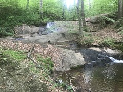
Looks out of place in the Atlanta area, but it's not too far from my house. The creek doesn't have any official name on any map, just some little feeder of Nickajack, but Blackhawk Trail encircles it, so I'll call it Blackhawk Creek until I know better.
Cool find.
About a month ago Kathryn noticed a ride, on Facebook I think, that struck her as exactly the kind of thing I'd be into. "It's called Tour de Liverance!" I'd heard of it but I didn't know when it was, or any other details, so I looked it up, and oh yeah, she was right.
At the time we were in the middle of a move, Florine was coming to stay with us the next week, and we'd be really unpacking the week after that... So, it wasn't until a week and a half ago that I finally signed up. Funny thing there though, I'd crashed at Cochran Mill earlier that day, busted a rib, but not yet realized how bad it was until the next day, AFTER signing up.
I don't know if it was fractured or just bruised, but it was definitely "busted". Sadly, I know from experience, that busted ribs hurt terribly a week later, then quickly get better. The ride was a week and a half out. I reasoned that it wouldn't be pretty, but it was still doable. In fact, it worked out better than I'd expected. Friday night I was only a little sore. Saturday morning (at 5AM!) I felt almost fine.
I grabbed some breakfast at the local Waffle House, which is now a different Waffle House from what used to be the local Waffle House, and had fun talking to the ladies that worked there. "How you know the Waffle House lingo for ordering?" "I've been eating at Waffle House for like 30 years!" "30 years! He said 30 years! You get a 10% discount for coming here for so long!" Waffle Houses vary significantly in how they execute "order scramble WELL" but this one was perfect, and it made me really happy that my new local Waffle House is so good.
Ellijay is like 1.5 hours away, so I got there right after 7, but the lot at the Ellijay Primary School was empty. 10 minutes later I saw what looked like volunteers start to assemble, and it looked like maybe a little further down the street was where we were supposed to meet up. Yep, there were Corvus Racing flags flying on either side of the bridge over the Ellijay River...

...and tents in a little parking area beyond.
Chris Gray, event director extraordinaire, met me at the tent and got me checked in. I knew his name from seeing it on the TNGA roster either last year or the year before, and I recognized him from having seen him milling around the start as well, but it was cool to finally meet him. I didn't know how he'd fared in the TNGA though, so we talked about it a bit. Turned out he'd crashed on the Hickory Nut, landed on a big rock, right into his IT band, wasn't able to sleep it off that night, and had to pack it in the next day. No shame in that. It's a tough route, and the Hickory Nut has a eats bikes and riders alike.
It was over an hour and a half until the start, so I kicked back in my truck and rested for about half of that. Everybody in the world started showing up though...
 ...so I got up and got ready when the excitement finally got to me.
Ready to ride.

Well, kind of. I'd originally put my number on the bars, both out of habit, and because I never liked putting it on my jersey. If you put it over the pockets then you're constantly trying to reach between it and the pocket. If you put it higher up on your back, then it flaps around and you can feel the safety pins. When in Rome, though, right? I ended up moving it to my jersey, and, as expected, kept trying to reach between it any my pocket all day.
I saw Mark Johnson for about 2 seconds somewhere in there. I also ran into Kate Gates and she introduced me to Mike Rasch. Mike's quite a character. He's also a New Orleans boy, and a 2-time TNGA finisher, so we had a lot to talk about! There's some festival going on in N.O. this weekend, so he's up here getting away from all of the tourists. We used to do the same thing: Oak Mountain and Tsali, every major holiday.
We didn't have too long to talk though. I wasn't sure how well the SAGs would be stocked, and I needed to run to the store for some calories. When I got back, it was time to line up.

I recognized the kid lined up next to me from the Cartecay New Year's Day ride. He and a buddy of his had hung with the leaders all day, and they'd both attacked me on the final couple of climbs, which was a great surprise at the time. He was doing the "short" option, but it was still the longest ride he'd ever done. It's quite a thing when you're lined up on a mountain bike, and the short option is 45 miles. That's the sport these days!
We had a few minutes left before the riders meeting, so I powered up my GPS, and waited. And waited. And waited some more. And some more. Nothing. It would not acquire satellites. Continue Acquiring. Nothing. Retry. Nothing.
Yikes! Clouds and space weather. I don't know. It's happened before.
I missed most of the meeting running back over to the tent to get a cue sheet. I almost missed the start.
Go!
I'd lined up at the back, planned on coming in DFL, and as such, had a nice, lazy start.
It had me a little worried though... There were three ride options - 45, 68 (I think, 60-something), and 105 miles. I was doing the 105, but the 45 mile riders turned left at the first turn, while everybody else turned right. Which way do I go? I checked and double-checked the cue sheet before turning right, and then checked it like 3 more times to be sure.
That sucked, so just in case, I kept trying to get my GPS to acquire, and 5 or 6 turns later it finally did! Woohoo! What a relief.
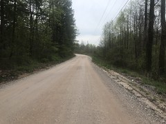
From downtown Ellijay, we took some scenic back roads over to Gates Chapel Road. And I do mean scenic.

How I never discovered these roads on my own is a mystery, but a lot of them were new to me.
From Gates Chapel Road, we spun up over Holly Creek Gap and back up over Mulberry Gap, for the first good climbs of the day. I somehow set a PR on the climb from CCC Camp Road up over MGap proper. I also rode behind a guy who kept making wrong-turns because he had his GPS zoomed in too much for the lag. He eventually got it straightened out, but we kept passing each other for a while.
Somewhere in there, I also ran into a guy that I'd ridden with a few times and our conversation went something like this:
(him) "It seems like I know you from somewhere. Did we ride together recently?"
"Yeah, I think we've ridden together a couple of times. Did you ride the Fireball Fiasco this year?"
"Yeah, I rode it with (two people's names that I don't remember). Oh! You were that guy that got in the water!" (hits brakes and drops back laughing) "Josh! Josh! Hey! Oh my gosh! This guy is crazy! ..."
I think it was Josh. I couldn't hear the rest of their conversation because we hit a downhill right about then, but what I had heard made me crack up laughing.
It started raining a little south of Hwy 52, and it made everything shine and glisten.

Sad that the photo doesn't do it justice.
It got a little cold there for a while too, and I feared I hadn't adequately prepared for the weather.
SAG 1 was at a church somewhere back near Ellijay. The rain had died down by then. Some kids were blowing vuvuzellas as the riders approached, and the SAG workers were cheering. They held up my bike while I stuffed my face with pastries and candy from the elaborate banquet they had laid out for us. Each of the SAGs were Deliverance-themed. This one was named Banjos and Bacon. Everyone was wearing overalls and the banquet included all of these elaborate bacon candies. They looked so good, and smelled even better. I craved the salt in them, but I feared that if I indulged, that it would sit in my stomach for hours, denying me any additional nutrition for the duration.
Dangit! No bacon.
The batteries in my GPS were sketchy Circle-K brand garbage, and had already worn themselves out. I'd brought a pair of trusty Duracells along to manage that exact eventuality, and swapped them at the SAG. This involved detaching and reattaching my GPS. The unit itself is a super bulk monster from like 2006 and I won't even attempt to describe how incredibly rigged-up and ghetto the mount was, except that it involved duct tape, zip ties, and a mount for a different GPS unit. It must have looked ridiculous to the NICA kid holding up my bike. Thanks to him for not laughing.
I'd hoped that it wouldn't have to reacquire satellites, or would have a quick and easy time of it, but no, it took like another 45 minutes, and my cue sheet had already been destroyed in the rain. Fortunately the route was actually marked! I didn't know this when I started the ride, but I probably would have if I hadn't been fooling around with my GPS during the riders' meeting.
The irony.
Every turn had either a series of orange arrows painted on the road, a little yellow sign, or both. In a few locations there were ribbons too. There had been a few spots, transition to or from gravel, where the arrow had been worn away by the time I'd gotten there, but overall, it was pretty good. Unless I just wasn't paying any attention, I figured shouldn't have any trouble. And, this turned out to be the case. I was able to follow the arrows until my GPS figured itself out.
Somewhere in East Ellijay, I passed a house with a perfect little concrete quarterpipe merging up out of the curb. Looking at it, I couldn't imagine any purpose for it except being an actual ramp. It was super tempting. It was even on my right, and I like to turn left in the air. Super tempting! But I had a long ride ahead of me and there was that one time at Bull Mountain where I tore my sidewall indulging in almost the same kind of shenanigans and had to limp it through the rest of the ride. Not today! Moving on.
Almost immediately after that we started climbing this sadistically steep climb. It was right in the middle of some neighborhood too. The houses were notched in there weirdly, and it gave the whole thing the feel of a Brazilian favela. A mail truck passed me right at the bottom, and I leapfrogged it all the way up the hill. It must have been terribly frustrating for her because I couldn't easily stick to one side and she had to wait for me a few times.
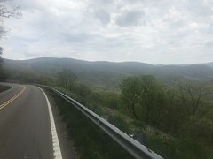
We eventually made it out to 575/515...
...and the road immediately became beautiful gravel.
Perfect tread. Tons of little rollers, just the right height and pitch to carry. There was also weird scenery.

And a derelict rail.

The guy with the GPS trouble was on my tail the whole time too. We kept passing each other when one of us would have fiddle with something. There was nothing I could do to drop him, but I could stay reasonably far ahead of him if I could get ahead.
The elevation profile showed 2 big climbs - one was early in the ride, basically the entire Holly Creek/Mulberry Gap area. The other one was up over Burnt Mountain, which I knew was way later. There were little kicks elsewhere too, but the severity of them wasn't immediately discernible from the data. That East Ellijay Favela, for example, wasn't obvious. Nor was the big kick up Raven Cliffs Road.
That came next.
Woo, hoo hoo!
Quite a climb.
At the bottom, there were a bunch of blocks of something on the right hand side of the road. Tailings, they appeared to be. I wondered if the "cliffs" were a quarry face. Maybe limestone or marble, considering the location. I couln't see any cliffs through the woods, but I figured they must be back up in there somewhere. Definitely bears further investigation.
I was way out of my element by then too. I know the NF like the back of my hand, but I've never explored much south of Ellijay. I've driven over Burnt Mountain, but never ridden or hiked any of it.
Adventure!
Somewhere after Raven Cliffs there were these weird cows with a big white stripe all the way around their midsection.

It's kind of sad that I don't know what they're called, considering how much time I spend driving and riding around in the country, and many millions of cows I've seen in my life. But, somehow, I don't know cows. Whatever they are, I don't remember ever seeing that kind before, and they were very interesting at the time.
SAG 2 was at Chateau Meichtry.

Moonshine Madness, it was called.

Their banquet had been decimated by the riders that had already been through, at least as compared to SAG 1, but there was enough left to stuff my face again. I was actually still good on beverages too, so I didn't bother to fill up.
Graham Skardon and Mike Rasch were hanging out up the hill a bit. Graham is another PBR rider, so he came down and Kim Murrell took our picture together. I didn't immediately recognize Jason because he's grown out this triumphant beard since I last saw him. He gave me a hug, and thankfully didn't crush my ribcage too hard. They weren't riding, just hanging out, but it was a treat to see them. Totally unexpected. Kim's got this ruthless Vista 350/Mountain 450 ride up in Tennessee that is alleged to make the TNGA feel like a training ride. Not sure if I'll ever be in the right kind of shape to do it, but it's definitely on my list.
I stretched a bit, and laid down in the grass, but I felt surprisingly good for being halfway done, and figured I'd better get going before my legs got too cold.
Somewhere past SAG 2 there were markings on the road for the different loop lengths, and I got this song stuck in my head after reading them. I don't know the name of the song, but it's some trap song that Billy and I were listening to a while back while working on his condo. The guy basically calls out denominations of bills that he's throwing at strippers. He mostly says "twenny... twenny..." but then every now and then "hund'ed". And that got stuck in my head: "hund'ed". Over and over. I must have said it out loud 15 or 20 times over the next couple of miles and I'd crack up sometimes when I realized that I'd actually said it out loud.
So ridiculous. My ridiculous brain.
Somewhere in there, my back tire started feeling squishy. Yep, getting low. I had 2 CO2's, so it hit it with half of one of them and kept going. A couple of climbs later it was getting soft again, so I stopped at the next intersection to fix it.
My 20 year old bike has non-tubeless 26'ers, but these days, all non-tubeless tires are "tubeless-ready" (even 26'ers), which basically just means that they're really tight on the rim. They're tough to get off, even with a lever, and after yard-sale-ing the gear I was carrying, I realized I didn't have one. Dangit! I knew I was forgetting something. 5mm to the rescue. It takes a while, and a lot of force, but it's possible to work them off with the wrench. Score.
Mike and Graham showed up right as I was putting it all back together.
"Did you see that bear?"
"Huh?"
There was a house on the corner there, and a bear was in their driveway, probably going for the trash cans. It had been 40 yards away from me the entire time, but I had not seen it at all. I had seen a turkey, some kind of quail, and a groundhog earlier, but not a bear. Mike and Graham had though, and Mike even got a photo of it. This led to a general discussion of bears as we rode away, and it was a really fun discussion because Mike apparently likes to personify bears, attributing human behaviors to them like verbal communication and dancing.
A few turns later we started crawling up Burnt Mountain.
Crawling.
A black truck passed us, and some chick "woohoo'ed" out the window at us. Mike recognized the truck as Kim and Jason's. The woohoo-girl was Kim! Ha!
We hit the Burnt Mountain overlook a few minutes later.
Check out Mike's awesome kit.

High visibility!
A few minutes later we passed Jason and Kim on the side of the road taking pictures of us.
Graham and Mike eventually pulled away from me, and Jason and Kim drove back by us.
At this point, I wasn't feeling pretty weak. All climbs were crawls. I rested on every descent. I stretched a lot. I felt like I'd make it through the ride, but that, overall, my fitness still had a long way to go.
Up the road a bit, the Canton Cartel guys had set up an unofficial SAG.

I'd just run out of Gatorade, and my other bottle was full of Tailwind, which I'd picked up at the first SAG, but never tried before in my life. They had water and more Tailwind, so I filled up on water and kept moving.
The drop off of Burnt Mountain was insanely fast. It was like dropping off the back of Hogpen, but the turns were lazy, so I didn't have to hit the brakes much at all. Man! I don't believe that I could have gone faster on that bike. It was amazing.
I was well past the halfway point by then, and though the ride had decidedly transitioned into the "work" phase, it had not yet become "suffering". The scenic backroads, all new-to-me, did a lot to keep my spirits lifted too.

Somewhere in there, I ran out of the little chocolate donuts and honey bun that I'd brought with me from that store in Ellijay, and started cracking into the "Chocolate, Nut-Butter Crackers" that I'd picked up at the first SAG. Oh, glorious confection, where have you been all my life? It was like eating a peanut-butter chocolate ice cream cone, when you start having to take bites of the cone. So good. And not terribly sweet, unlike that honey bun that had been making me a little sick at my stomach for a while now. It was a bit dry, but thanks to the Canton guys, I had plenty of water.
Actually... I say that. It wasn't the hottest part of the day, but it was still pretty hot, and I was chugging that water. A few miles from SAG 3, I was out, and started to hit the Tailwind. I've never had Tailwind before, and didn't know what to expect. Turns out I should expect it to be very salty, and to have a lingering aftertaste. It reminded me of Heed. It didn't taste like Heed, but I remember that I first got Heed at a SAG on the ORAMM and was equally surprised by how it salty it was, and by the aftertaste. Also, neither are especially citrusy, which I'd come to expect in a sports drink. It also didn't help that I was passing a warm cow pasture when I took the first swig, and the delicate interplay of aroma and aftertaste really put me off. I'll have to try it again under more controlled conditions to decide if it's actually gross or not.
Either way, it was what I had, and I was really putting it down for the next few miles.
It was after 5 as I approached the 3rd SAG. Chris sent out some pre-ride information that there was no guarantee that they'd still be there after a certain time, or have anything but water left if the were. In anticipation of this, I'd figured out where pretty much every gas station or store within a few blocks of the route was, from SAG 2 on, and put waypoints in my GPS for them.
When I hit Simmon's road, I knew that Stanley's Chevron was a couple of blocks off-route to the left. They, for sure, had anything I could possibly want, so I opted for that over SAG 3. Somehow I failed to take a photo of it, but my brain was operating in low-power mode at the time, so hopefully that can be forgiven.
Two gatorades and half a can of coke later, and I was feeling like a new man.
As I got up to get moving again, an older gentleman drove up to the spot next to the one I was sitting in.
"You about rode the tires off of that bicycle didn't you?"
"Darn near! Yes, sir!"
We both grinned these wide grins as I got up and he went it. Somehow he beat me though. Whatever he was after only took a few seconds, and he was back in his car before I was quite on my bike.
Mike and Graham were turning off of Simmons Road right as I got back on-route. Ha! "I wondered if I'd run into you guys again!"
SAG 3 was less than a mile later though. There was a crowd of smiling, cheering, overalls-wearing yahoo's there to greet us, so it appeared that I'd been a little too conservative with my trip to the gas station. Mike and Graham turned off, but I kept moving.
Not long after, I was bombing down some sweet, wide gravel road, just having passed three guys fishing off of a bridge, when I noticed that I wasn't quite following the route any more. GPS jitter? Maybe. The route was off to the right a ways, but I figured if there was a road down there, I ought to be able to see it, and I couldn't see anything.
So, I carried on a bit, just to see if things would converge. Nope.
The heck? Did I miss a turn?
Maybe back at that creek?
Yep, there was a turn there. Well marked with paint, a sign, and ribbons. I just didn't see it. Thank the Lord for a working GPS!
And I quickly realized why I couldn't see it through the woods.
Not exactly a road any more.

When it did become a road again, it had been freshly covered in big, chunky, wrestling-match gravel.

It took forever to climb. Chunky, steep, relentless hills.
What sadistic madman throws something like that in, that late in the ride? The very audacity! I love it!
When that was over, the route quickly became straight-up singletrack.
And there was an old abandoned car back in there, just for good measure.
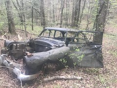
Yeah, I'm supposed to be cranking out miles, but if there's an old car back in the woods somewhere, it's hard to resist the urge to get a photo and mark the location.
Not long after, I emerged on Turniptown Road, and I kind of knew where I was. It had been cooling off for a while too, and I actually felt really good climbing again. It was, at least, much less of a crawl than some of the others had been, earlier in the day.
There was some final-insult though. At what I imagined was the top, based on the GPS track, there was actually a bit more climbing, and then when you did start to descend, it would be a quick drop, followed by another little kick, then another quick drop. No sustained descent, and each subsequent kick was a little too much to carry.
Ha ha! You madman!
When I hit Hwy 52, I felt very relieved. I knew where I was, for sure, and it was almost dead flat to the finish.
Approaching downtown, I imagined a 1K kite strung over the road.
There was no actual kite, but there was one in my mind!
Chris was standing on the bridge, getting everybody's number as the riders came through. I didn't immediately realize that I was finished. He was standing at the start point, but I'd lined up way back from that point, so it felt like I had to keep riding up over the bridge to actually finish.
I was, in fact, done though. And man, what a ride! Great route. Unexpectedly difficult. There were so many kicks that didn't show up in the elevation profile. There was that East Ellijay favela, that Raven Cliff's Climb, that rough section at the end. And I hit Burnt Mountain in the hottest part of the day. All unexpected. I really got my money's worth.
After taking a second to collect my senses, I met Chris's family, who were all there together at the finish. Beautiful family. They all have glorious hair! Chris's is in the form of an amazingly long, braided beard. His daughter's is long, curly, and shockingly red. And, his son's is long, blonde, and wavy, almost exactly how my nephew wears his, and how I kept mine in my late teens and twenties. His wife was wearing a hat, so I couldn't tell what hers was like, but it's statistically likely to also be amazing. Seems weird now to go on and on about their hair, but seriously, it was that striking. His son and daughter are both NICA riders, so who knows, I may end up on a ride with them some day, if I haven't already.
There were burgers for the finishers out back of the coffee house next to the bike shop, so I spun back into town and got myself a couple. When I got there, Graham and Mike were already there. They'd apparently passed me when I taken that wrong turn. Dangit! In fact, there was only one guy left out on the course. I'd come on second-to-DFL. Ha!
We all talked about Louisiana, the TNGA, and some of Karlos's rides while our burgers sizzled on the grill. And, man, when they were done sizzling, those burgers really hit the spot. It was one of those times where you don't realize how hungry you are until you start to eat too.
So good.
I was surprisingly not tired on the way home. Not sleepy at least. I didn't even sleep in today. Me and Sophie got up at 9 to go shopping for jeans at Old Navy. I did nap about half of the afternoon away though, so maybe my fatigue was just delayed.
Whatever the case, I feel pretty good right now. Sometimes I don't want to even look at a bike for a week after a long ride, but not this time. I hope that bodes well for my fitness. I guess the next few weeks will tell.
There's not usually much noteworthy about my little after-work rides, but occasionally something interesting does happen...
Now that it's light until 8:30 or so, I'm able to hit Cochran Mill after work, and I did just that last week, with my brother.
We weren't a mile and a half into the ride though, when I hit something that pulled the bars out of my hands and sent me flying over them. I managed to crush my pelvis into the stem and then drag both legs along the backs of my brake levers during the ejection before slamming into the ground on my right shoulder. Total yard sale. Everything went flying out of my pockets and both bottles went flying too. Knocked the wind completely out of me. Whoo!
My ribs ached, but other than that, the whole thing was funny when I could breathe again. It was even funnier after that because we couldn't find anything that I could have possibly hit. It was like those invisible rocks that used to knock me off of my skateboard when I was a kid.
Ehh, whatever... We rode another 18.5 miles, packed it in, and had some dinner at some Mexican restaurant. The food was delicious, but the service was probably the worst I'd had in years. The guy was trying. Not his fault. They were just impossibly understaffed.
The next morning my ribs felt good and busted. Probably just bruised, but still, they hurt. I did a little local ramble that day, but I could really feel it. Since then, I've been shuffling and unpacking boxes all day and night, and it's not helping at all. Busted ribs usually feel the worst 1 week later. That'll be 2 days from now, and I'm not looking forward to it.
The Tour De'liverance is this upcoming weekend. I hope I'm adequately healed for that.
If not, it'll be quite a ride.
Goodness, we've been busy lately. We spent a week moving into a new house, then we had a french foreign exchange student stay with us for a week, then we spent another week moving in the last bits and unpacking... I've barely had time to think, much less write.
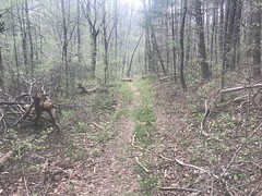
Before all of that, I'd just been exploring the area around my house. I'd always heard that there are trails around here, but never made a solid effort to find them. Turns out ther's lots of greenspace, and little scraps of trails through a lot of it. Strung together, they make pretty satisfying "local rambles" as I've been calling them on Strava.
In addition to the trails, I made some of neat discoveries during some of these excursions too.
For example, these are pulleys from some old machinery, just discarded down along some feeder creek of Nickajack.
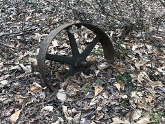
That one's broken. The one below is in better shape.
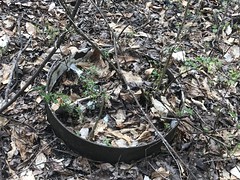
They were painted white at some point.
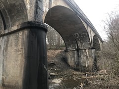
I eventually discovered a way to get down to the modern trestle over Nickajack Creek, near my (old) neighborhood.
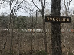
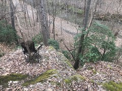
And, I discovered the semi-official trail system behind it as well. I say semi-official because, though it's not publicised anywhere, it's semi-well travelled, blazed, and even has an overlook, with official-looking signage:
...an complimentary chairs.
On sepearate excursions, I discovered even more interesting things along Nickajack Creek as well.
Apparently the sewer line used to be a railroad grade. An inactive trestle once lead tracks over from the side that the modern railroad grade runs along.
Isabel went to school with a local kid named Gary, and I eventually kind-of got to know his dad (Gary senior) and mom (Sheila) from seeing them at the local pizza place for years. They've lived here since they were kids and their folks since they were pretty young too. They also know a guy named Everett who really knows the area and showed them all kinds of obscure details.
For example...
When the tracks were first laid, they ran along this side of the creek for about 15 years. Then the railroad switched them to the other side, and they've been running on that side ever since. It's not exactly clear how far downstream it once ran though. I wonder if I can figure that out?
There are plenty of artifacts and local landmarks too...
This one is Turtle Rock.
Though I couldn't figure out what direction I had to look at it for it to look like a turtle.
This one is Alligator Rock.
The pothole in the middle of the creek is supposed to be the nostril, and the eye is another pothole right up at the bank. The eye isn't super visible these days though.
At first glance, to me, it looked like the nostril pothole was the eye.
Either way though, it looks alligator-ish. Legend has it that the local Native Americans carved the ridges in the neck/body area, and closer examination does show that the stone was worked.
Neat!
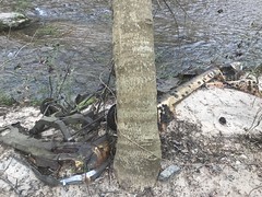
There's an old, abandoned, Dodge/Chrysler near Alligator Rock too.

And just downstream from there is another Turtle Rock, AKA Softball Rock.

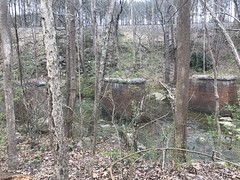
On the north side, there's an old rock wall. I noticed it my first trip out there, but couldn't tell what was going on. It looked like a facade with some concrete structure behind it, but that's all that I could tell.
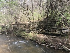

Turns out it was a swimming pool! It's completely filled in with sand now, but there was once a swimming pool down along the creek, fed by water from the creek.
The heck? A swimming pool?
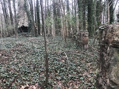
Well, just uphill lie the ruins of Camp Highland, a YWCA camp that was in operation from the early 1900's until about 1960. Gary's mom went to camp there when she was a kid!
There are various photo collections online:
And a great story about a guy who's aunt went there as a kid.
I had to go back and check it out!
Getting to it is tricky though. In the early 1900's people apparently arrived by train most of the time. The camp sits right on the tracks. The trail would stop, passengers would get off, and that was it. Until at least the 60's, Camp Highland Road also led from Atlanta Road to the Camp. The subsequent construction of South Cobb Drive and East-West Connector broke up the north/east end of the road, and it now dead-ends onto the Glock campus. There was once a parking lot for the Camp where Glock's southern lot is, though it, and the old road have been bulldozed entirely out of existence. The camp, as far as I can tell, is completely cut off from the rest of the world. No modern road or trail leads to it. You have to just know it's there, and cross Nickajack Creek at Alligator Rock to get to it.
So, that's what I did. There's an old roadbed on the other side that leads to the tracks, so I followed that until I started finding things.
The first thing I found wasn't any part of the camp itself, but another old, abandoned car. This one was allegedly a Chevy.
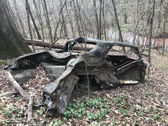

Not sure about the model.
Across the tracks, the old road became terribly overgrown, before disappearing entirely into the modern regrading for the Glock lot.
Walking south along the road, from the tracks, I discovered some tall footings on the right side of the road.
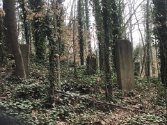
Some were toppled, but many were still standing. A wooden cabin would have sat atop them. There's an active 4-H camp near the Atlanta Airport that has a bunch of similar structures, still standing.
That particular cabin might have been the Arts and Crafts Building.
Across the road, on the left side was the Dining Hall - an impressive three-chimney structure.

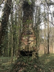
There's an old photo titled "Main Building" in one of those collections that shows a smaller structure with a single chimney. The third chimney may have been that single chimney. The rest of the building may have been built off of the front of that building later.
There's a discernible loop through the grounds. It leads south from the tracks, around the Dining Hall, then hooks right and descends almost to the creek, where it hooks right again and climbs back up to the tracks.
The most discernible trail through the grounds these days continues past the dining hall though, past an abutment for an old footbridge.

When the car lot was built, on the other side of the tracks, this footbridge led from the lot to the camp, suspended some 20 feet over the railroad cut below. I could imagine it as some kind of final test for any would-be campers. If you were brave enough to cross the bridge, then you were cut out for camp!
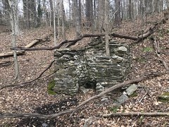
Near the bridge, was this old chimney ruin.
u
This was apparently the Infirmary. An old map shows it to be the Manager's Residence too, but I'm not so sure of that.
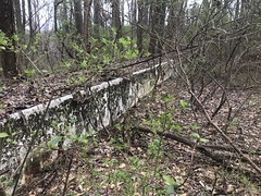
The trail bends around to the south past that chimney. There was once a large field there. At the northern end, they used to do archery. On the east side, there were originally teepees, then cabins, then eventually a swimming pool. In the south-east corner there were a couple of bath houses and a flagpole. On the south side was a two-story cabin for older girls. Along the west side were a row of cabins for younger girls.
The swimming pool is almost completely filled in now, and the southeast corner of it was broken out at some point, but a good bit of it is still visible.


Here are the footings for the main cabins.

There's a basement behind them, perhaps for a storage room.

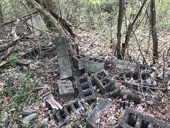
Someone restacked the cinderblocks for some purpose.

There was some evidence that homeless people have camped back there. Maybe it served some purpose for them.
The flagpole had recently rusted out and collapsed.
There are photos of it online still standing though.
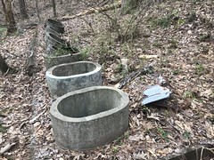
One bathhouse.

Some grey-water tanks, I guess.

Another bathhouse?

This was confusing at first, but I later realized what it was - a latrine.
From there, the trail was less distinct, but it led around to another chimney ruin. This might have been the 2-story cabin for the older girls, or maybe the Manager's Residence.


There were more cabin footings across the road from it. This cabin may have been the one for the older girls.

There's a photo of the interior online, but you can't tell much from it.
Downhill from all of that are a couple more roads.
One basically spurs off of the main loop and runs around the perimeter of the camp, kind-of just behind everything. Seemed like maybe a maintenance road.
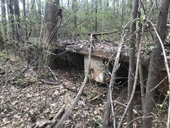
On that road, near the main camp, there was another cinder block basement.

Maybe equipment storage.
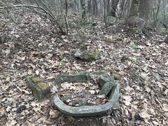
Way down at the end of the road, a little bit uphill, was the primary latrine.
I wouldn't have known what it was except that Gary mentioned the vault and the 8 holes. After discovering this latrine, I recognized that other circular concrete thing that I'd seen earlier. This one was downhill, behind the pool, a good bit away from the cabins. I guess it's the high-traffic latrine, where everyone went during daily activities. The other one was right by the bathhouses, and much closer to the cabins. Smaller, but more convenient, especially at night.
There was also a large pit dug nearby, but a little ways away from the latrine itself.

It didn't look related. Strange.
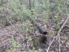
Kind-of in the middle of nowhere, halfway up the back side of the main hill, there was this well house.

It appeared to be built above a spring, and had lots of pipes running out of it.
I guess it was the main water supply, but it's hard to say. It doesn't seem offhand like it would provide enough for the camp, but maybe it did.
One of the old roads eventually ran along the creek and eventually blended into the general flat area next to it. It may have continued for some longer distance, but I didn't explore it further.
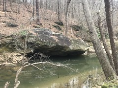
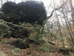
There were a few trails along the creek as well, one of which petered out after this big overhanging rock.
Another led west and continued further than I had time to explore that day. I know there's a large culvert under the railroad grade to the west. I'd seen it from the other side, and there are old photos of girls playing down by it, so the trail must have led at least that far along the creek in antiquity. Something to go back and explore, for sure.
Quite a find! It's amazing how busy it was for so many years, to now be so completely cut off from the rest of the world. And to think it's been sitting there behind my neighborhood for all of these years and I didn't know about it.
There are alleged to be even more sights to be seen along the creek - an old Thunderbird, some bear-claw marking somewhere...
Plenty more to explore!


