Monday, December 28, 2009

Dauphin Island

This morning I got up inconceivably early, or at least inconceivably early for being on vacation. I'm in Baton Rouge visiting family and as it turns out, Brooke is in Mobile visiting family too. By my definition, Mobile is close to Baton Rouge, but only if you get up at 5am.

Drivin'

We met up at her folks' place. Brooke was rocking a sweet military haircut. It was cold, but not unmanageably cold.

Brooke

The plan was to ride out to Dauphin Island, spin a lap and ride back. But first things first. I'd had an entire Dr. Pepper on the way over, peed 3 times and needed to pee one more time before we left. I also had to pee about 10 miles later.

We had a bit of a headwind and some mean crosswinds all the way out to the island. Riding in the mountains so much I forget about wind. I mean it's there but not like it is down here. The roads were quiet though. Not too much traffic.

When we started getting close to the island, the scenery got interesting. Marshland to the west. Mobile bay to the right. 50 different kinds of huge birds including Brown Pelicans, Grey Herons and some cool duck that looks like a penguin.

We could see the one big climb looming ahead of us. "Little Beach Gap" she calls it. It's a long story.

Dauphin Island Expressway

The view from the bridge was amazing. And the shoulder was wide enough to enjoy it without worrying about traffic.

On The Bridge

On the island we stopped at a Circle-K for another bathroom break and ate some homemade confection she'd brought along. I don't know exactly what it was but it had chocolate and coconut in it I think.

On the west end of the island recent storms had covered the road in sand and water. We pushed through it for a while but eventually it was more sand than road.

Storm Damage

On the other end we rode past Fort Grimes and the public beach.

Fort Gaines

There was a ferry on that end too that takes you across the bay to Gulf Shores. We talked about one day riding out, taking the ferry and riding back. Man, that would be epic.

I stopped to pee again at the Circle-K and we started back. The headwind was like climbing Woody Gap if that climb was 25 miles long. At one point I saw a mile marker for mile 11 and then an impossibly long time later I saw mile marker 16. It was going to be a long day. A few miles from home we were both out of food and slow-bonking. A quick trip through a country store fixed that and, yes I had to pee again. Actually I'd even stopped about 5 miles back to make use of their facilities too :)

I don't think this ride quite qualifies as epic, but it was way harder than I expected. At the end, my brain was running on about 3 cylinders. It was exactly what I love about cycling though. Really fun, then really scenic, then really hard. Excellent.

Brooke's mom made us some lunch when we got back and I bailed out back to BR. It took about half of the trip back for my brain to reboot.

Saturday, December 26, 2009

Baton Rouge

I'm in Baton Rouge visiting my in-laws for Christmas. My sister-in-law is also getting married on the 2nd so were down here for that too. I ate waaaay too much yesterday so this morning I jumped out on the road for a couple of hours in a futile attempt to do something about that.

At 8am on a Saturday in Baton Rouge everyone is still asleep. Possibly still hung over. I was alone on Highland Road.

 Highland Road

One of my favorite things to do is just ride around a city like a tourist for a couple of hours. You get to see stuff up close like if you're walking but you get to see a lot more stuff.

The LSU clock tower...

 LSU Clock Tower

I spun around the LSU lakes too. There were pelicans, egrets, cranes, ducks of all kinds, and some birds I couldn't identify. Cool to see so much wildlife in the middle of town.

 LSU Lakes Pelican

This is the high school I graduated from, deep in the BR hood. Go big blue.

 McKinley High

They're doing construction so the barbed wire is missing from the fence for now. But note the direction the brackets are angled. Inward. To keep students in.

 McKinley High Barbed Wire

Downtown Baton Rouge has a bunch of streets named St. This and St. That. There may be a St. Ferdinand but this street isn't named after him. Legend has it that a Frenchman made all the street signs way back. In French Ferdinand Street would be Rue Ferdinand. Rue meaning Street and coming first. So when making the signs, he put St. before the name. Signs were expensive back then so they just went with it. But they did catch the error before he made a saint out of Napolean.

 St Ferdinand

The Wall. I used to skate that way back in my skateboarding youth.

 The Wall

The Fake Handrail...

 Fake Handrail

The tall handrail at the church. I slid it in '92, was the first to do so, and it was apparently regarded as legendary for quite some time.

 Church Handrail

The State Capitol building.

 State Capitol

The two trees I think of when I think of Louisiana...

The Great Southern Live Oak...

 Great Southern Live Oak

The Southern Magnoila...

 Magnolia

Both grow in Georgia too but not as large and sprawling.

The Governor's Mansion. Hard to get a good view of it actually.

 Governors Mansion

The cannons. We used to ride bikes down the hill. Looks like folks still do.

 Cannons

The Pentagon Barracks. There are 4 buildings. The 5th side of the pentagon is the river.

 Pentagon Barracks

The Old State Capitol building. Declared by Mark Twain as the ugliest buiding ever built. Or something like that.

 Old State Capitol

I have no idea what this is or what it's really called. We call it The Paperclip.

 Paperclip

The USS Kidd and Mississippi River Bridge behind it.

 USS Kidd

Red Stick Plaza. Baton Rouge means Red Stick. Allegedly when the first white settlers arrived there was a Native American territorial marker at this site; a tree trunk stripped of branches and covered in blood.

We skated here a lot way back.

 Red Stick Plaza

Tiger stadium as seen from the levee. Geaux Tigers.

 Tiger Stadium

I had to burn it right down to get back home for 10. The roads are dead flat but in Baton Rouge there is always a headwind. I should be able to get in a ride tomorrow too. We'll see.

Wednesday, December 23, 2009

Big Creek

My dad came to town, a little unexpectedly, today. I knew I'd see him around new years at my sister-in-law's wedding bit I didn't expect to see him in the ATL. Nice. We rode Big Creek.

 Dad

My buddy Tavis was riding out just as we got there.

 Travis

He and a friend of his, Richard, had been there about an hour or so already. They rode part of a lap with us. We rode three laps, taking three different routes, hitting most of the trails, even the greenway. The last time I rode Big Creek was the day after Mt. Mitchell last year, with my dad, no less. That day, my body was wrecked and he was having a hard time getting a full breath. Today was nothing like that. All fun, no pain.

Ahhhh.

 Bike

Sunday, December 20, 2009

Unicoi

I'm not feeling much like a cyclist these days and after all the rain yesterday I wasn't feeling motivated to change that this morning. Well, I say that. This morning me and the kids did ride bikes in the bank parking lot by my house. Sophie's finally learning what it means to really try hard; to try until she actually fails rather than just trying until things aren't going perfectly and giving up. Hopefully that will translate to other parts of her life. She's also learned to look where she wants to go rather than directly at the ground in front of her. That helps.

But back to that NOT cycling I was talking about...

I spent all day yesterday with my family, but lately I've really been wanting to spend more time with the girls. To that end, we went running around Unicoi today.

We started out on the Unicoi Lake Trail. Nothing special, but it did provide some nice views of the lake.

 Unicoi Lake

There was also a beach. It always feels strange to be standing on a beach in subfreezing temps.

 The Gerch on the Beach

Our lap around the lake was laaazy. We stopped a couple of times to take in the sights. No rush.

 The Girls Looking at the Lake

We even stopped to check out the dam. I took a few pics of it before the 6 hour a few months back.

Our original plan was to take the Helen Trail into the park from Helen, hike around the lake and take the same trail back. I figured, with the map, I'd just be able to drive around Helen and find the trail, but it wasn't that simple. Plan B was to hike the Lake Trail, then take the Helen trail out and back, but we walked right past the intersection with the Helen Trail and didn't feel like walking back across the bridge. I know. Sounds like a lame reason, but at the time, it just really didn't seem worth it.

Plan C was to drive up and check out Anna Ruby Falls. We've been up there twice before, but I've never GPS'ed it or taken any pix. And with all the rain we've had, the falls should be raging. Seemed like a much better plan.

The falls trail is paved.

 Anna Ruby Falls Trail

I'd swear it wasn't paved when I very first went there like 4 years ago, but I can't find anyone that can confirm that. Maybe it was paved then too. They've definitely done other work since then though. Two overlook platforms were built, or at least rebuilt this year. There are some new fences up to keep folks on the trail.

Smith creek was raging. It was looking good for the falls.

 Smith Creek

We were not disappointed.

 The Girls Approaching Anna Ruby Falls

 Anna Ruby Falls

It was cold next to the creek and even colder at the falls, but when I was ready to go, Iz argued "Dude, come on, it's not worth it yet!"

 The Girls At Anna Ruby Falls

Cold or not, she wanted to stay until she'd seen it long enough to make up for the climb. It was colder and wetter than last weekend at Harbins. I guess her clothing was working. Actually, neither of them complained about cold toes or fingers all day.

We checked out the Lion's Eye nature trail too, which is also paved, and maybe 200 yards long total. Not a very strenuous day, but a lot of fun. Exactly what I was looking for today. Now if I can just get back on my bike...

Monday, December 14, 2009

Brawley Mountain

With all this rain, I haven't been on my bike in a while and I'm starting to get that "I don't even feel like a cyclist any more" feeling. Yesterday brought more rain, and even more of that feeling. I mean, yeah, I could go turn 50 miles on the road, soaked, shivering and steadily forcing water into my cables, but it hasn't been that long yet. Maybe next week, we'll see.

Yesterday I hiked all over Brawley Mountain.

...but, it didn't start out so well. Every now and then I make such an impressive mistake that it makes me wonder whether I can really trust myself with a map and a compass. Yesterday's mistake was driving up to Skeenah Gap, mistaking FS640 for FS45 and getting all the way to Hwy 60 before I figured it out. Whee.

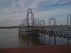
It wasn't all in vain. It did give me a chance to take a pic of this weird fountain thing.

 FS640 Fountain

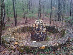
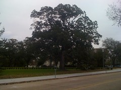
I'd seen it before but I didn't have a camera back then. I guess the area used to be a campground, or a farm, or somebody's mountain estate. Something. Makes me curious. The internet doesn't seem to know anything about it, so who knows. Next time I'll look around a bit. Yesterday I just wanted to get to Brawley.

I did find these two deer across the road from the fountain.

 Deer

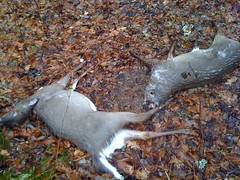
I guess I should say one and 8 tenths of two deer. I'd seen 2 more deer carcasses that day as well, more decomposed than these, chucked to the side along FS640.

Ohhh! And I almost forgot, I'm pretty sure I saw a young bald eagle. At first I thought it was a hawk, but it was shaped different and it was way bigger than any hawk or vulture I'd ever seen and I see those every day in Cumming, at all kinds of distances. It's feathers were mostly brown, but mottled all over with white, and it's breast was mostly white. It was about 40 feet off of FS640, at eye level. I assumed it was a golden eagle until I looked up photos of both. A golden eagle would be awesome to see, but a bald eagle is just that much cooler. I didn't take a photo because it was too far away and very well camouflaged. Deer don't even come out in iPhone photos at 40 feet away. Now I'm kicking myself. I should have at least tried.

Anyway...

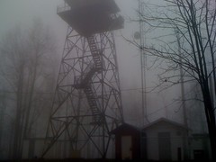
I found FS45, right where it was supposed to be, and parked at the gate. FS45 leads to a tower, so it's gated and even in hunting season, the gate is closed unless somebody needs to get to the tower. My plan was to hike out on the road, take an old 4WD trail down to FS82, then either bushwhack back up on one of the ridges, or just take the same trail back up and then take the Benton MacKaye back to the truck.

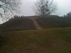
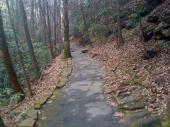
The road was well maintained and I made good time hiking out. Somewhere on the south side of Tipton Mountain I ran into this:

 Bleachers

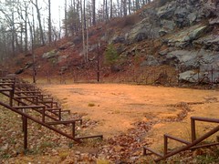
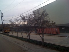
That's a small field, covered in sawdust, surrounded by bleachers with no seats and light poles with no lights, placed in front of an old Quarry. The internet does know something about these though. Go here, search for "bleachers", scroll down.

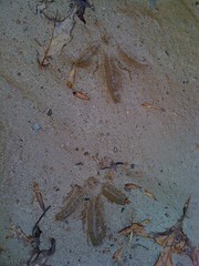
There were a ton of turkey prints on the road.

 Turkey Prints

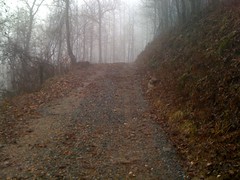
Did I mention the weather. It was 36 degrees and misting when I left my house, but in the mountains, the mist became fog and the temperature went way up. I was overdressed when I got to Brawley proper and shed my base layer for the climb.

 FS45

I'd kind of hoped for an abandoned tower that was still safe to climb. What I found was well-used and and the bottom flight of stairs was missing. So, pretty much the exact opposite.

 Brawley Mountain Tower

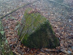
Just as I stepped onto the BMK, I ran into this artifact. I love finding old stuff in the woods, especially if it actually had a purpose at that location, like chimneys, rock walls, dams or, in this case, a concrete pylon. I guess they rebuilt the tower at some point and this was one of the original footings.

 Pylon

Earlier, on the road, I'd looked around for the 4WD trail shown on the map, but there was an overgrown powerline cut right through where it should have been and I didn't feel like getting cut to ribbons. The BMK should cross it. Once on the BMK, I figured I'd look for it again.

I did find a trail, not the trail that I was looking for, but a clean old roadbed, and it was actually heading in a more interesting direction, right down Rocky Knob Ridge. Change of plans: I'd follow it down to FS82 instead and see if I could take the other trail back up.

The trail was clearly got a good bit of use. I did see some ATV tracks, but they were shallow. It looked more like foot traffic.

 Rocky Knob Ridge Trail

At the bottom of the first steep descent, there was a wrecked up hunting blind.

 Wrecked Blind

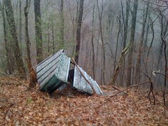
It didn't look too old, and it didn't look like a tree fell on it. Maybe the wind just had it's way with it.

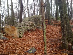
At Rocky Knob proper, the trail turned into a sidehill on the east side. I took a short trip up to the top of Rocky Knob. I figured, hey, I was right there, I might as well. It was fairly rocky.

 Rocks on Rocky Knob

North of rocky knob, the trail T'ed into a newer old roadbed. That T'ed into another and that led down to 82, exactly where I'd hoped it would. Woohoo!

I took 82 back south to the end and looked around. It looked like there might have maybe, kind of, might have been a road leading east from there, but if so, it was a loooong time ago. There was a very clear trail leading southwest. I took that. From there, I pretty much followed the path of least resistance back up the mountain. Sometimes that meant following an old roadbed, sometimes it meant sidehilling cross country, sometimes it meant just walking straight up or down hill until I found another roadbed. I eventually ended up at Ledford Gap. During all that, I even found the trail I'd originally been looking for, or at least part of it.

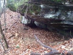
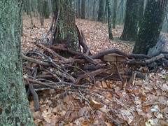
I found these two cool things too.

A small cave, formed by an overhanging rock. I always forget to put something in the shot for scale, but it was tall enough to sit up under, maybe even stoop. There was what looked a little like a fire ring under there too. It was totally dry underneath. Might be a good spot to camp.

 Small Cave

There was also this little shelter, or blind, or bunker, or something. Throw a tarp over it and you could sleep there. I've seen a couple of these before.

 Shelter

But I digress.

The BMK crosses through Ledford Gap and I had to decide whether to take it back or stay on the road. I had about 35 minutes of daylight left and it had taken me about an hour to get from the car to the tower. I had about 1/3rd less distance to go back the other way and it was mostly downhill. If I pushed it, I could make it on the road. The BMK was longer. It would be better to be on the road if it got dark.

I pushed it all the way back. Or, at least pushed it for me. I learned last week that I need to get used to jogging again, so I jogged as much as I could. That basically consisted of running for a minute or two until some muscle I didn't even know I had started burning, then dialing it back to a march until it recovered, then doing the whole thing again. I did that all the way back to the truck and made really good time. I beat the sun and even got home on time.

It is amazing how soft I've gotten with respect to running. When I was a kid I ran all over the place. Even in college, I played intramural football and softball. I ran all the time. I guess 10 years of cycling, even mountain biking, was low-impact enough to kill my tolerance. And hiking does not appear to be equal to running. It's so lame that I can't run, I can't even stand it. I've got to do something about that. It's going to be a long road I think, but at least I've got the cardio.

Harbins/Alcovy Park

This past Saturday the girls and I went back to Harbins Park. I say "back". I went back, they'd never been there before. I'd been there with my dad a few weeks earlier and we'd ridden all the bike trails, but the park has horse and hiking trails too and I can't let those go unexplored.

The weather was terrible; 36 degrees and sort-of sprinkling. That sprinkle where you can see the rain in the air, but if you look at your clothes, you can't see that any has actually landed on you. Misting may be a better word. Whatever you call it, it was cold and wet.

We took a shortcut up over a meadow to the trail and started walking.

 The Girls on the Harbins Hiking Trail

The trail was mostly like this:

 Harbins Hiking Trail 1

Barely worn in, incredibly twisty. So twisty that I could only tell where we were by comparing the terrain to a topo map. Trying to follow along on the map I picked up at the trailhead was almost impossible.

The cold was really getting to the kids; their fingers and toes were getting numb. They were wearing fleece-lined tights, but no socks over them. We dug around in their packs but all we had was 1 sock and a bag of candy. Iz put the sock on one foot and used the candy bag as a sock for the other foot. I tore the top half of the bag off, tore that in two and wrapped each piece around Sophie's toes. It worked, the plastic reflected heat back and their feet warmed right up. Their fingers were another matter. I unconsciously make fists and pull them into my jacket sleeves to keep warm. It was working for me. I showed them how to do it, but it was awkward and they decided they'd rather just be cold.

There was this cool boardwalk about a third of the way through the trail, with a good view of some slickrock and the Alcovy River. I should have taken a shot of the view too.

 The Girls on the Harbins Boardwalk

Other than that, there wasn't much to see.

I'd guesstimated about 2 and a half miles of trail, but I was way off. Around mile marker 3, the girls had had enough of the cold and rain. Our original plan was to hike the trail, then ride bikes on the Meadow Loop, but they were saying that they just wanted to go home. That was good, because as long as the trail was turning out to be, we probably wouldn't have had time to ride anyway.

I could see the hill we needed to climb over to get to the car, but every time we'd start heading toward it, the trail would switch back on itself and go the other way. This was seriously pissing Sophie off and she was almost crying...

"I hate this trail! More than any other trail, I hate this trail! It keeps turning the other way! Why does it keep turning the other way?!"

It was sad, but it was also really funny and me and Iz had to keep from laughing. Iz could see the hill too, but when we tried to show Sophie, she was like:

"What hill?! All I see is trees! There's just trees everywhere! Everywhere!"

I tried to show her how you could see the sky through the trees and make out the outline of the hill but she wasn't hearing it.

"What are you talking about?!!! The sky is everywhere! It's just the air, there's 2 trees right there with sky between them!"

I was like "No, look way through the trees, see how you can see the edge of the sky right there?"

"What are you talking about?!!! The sky is everywhere! The sky doesn't have an edge!"

Well, I can't argue with her there. Technically, there the sky doesn't have an edge. I tried to explain that it was the horizon, but she had a different idea of what the horizon was, and I was really just making things worse trying to explain it. Eventually I just told her that some days are hard and you just have to push through them. We all had to push through that one.

When we finally got out, 4.75 was written on the pavement at the edge of the trail. I guess it's 4.75 miles long; way longer than the 2 and a half I'd figured.

Back at the parking lot, the girls warmed up in the bathroom and I struck up a conversation with the only other guy in the Atlanta area fool enough to venture out in that kind of weather. He lived nearby and told me all kinds of things about the park. Apparently it was once owned by the farmer next door. The land had been condemned and the county paid 18 million for it. A serial killer was caught down by the shoals a long time ago. Back when the dirt roads were driveable, the rock face and the shoals were a popular teen hangout. There are the ruins of an old mill, a two chimney homestead and a moonshine still on the property too.

That last bit piqued my interest. When I come back to hike the horse trails, I'm definitely going to check those out. Next time I just hope the weather is better.