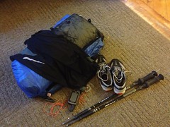
Thus, this past Wednesday, I assembled the now-familiar pile-o-gear...
...and after helping Isabel with her math homework until 10 o-clock at night, headed up to Asheville.
Kirk had somehow earned a free room at the Hampton Inn and we spent the first night of our adventure in complimentary luxury. The next morning we hit the continental buffet and wagon-trained up the mountain toward the gorge.
I recognized the area. Usually, I do a ton of research and get as familiar as possible with the general geography of an area and all the roads and trails leading in and out before I tear off into it. This time though, I did very little of that. If I had, I might have realized that I'd been to Linville Caverns before, on a trip up that way with my in-laws several years back, and that I'd driven up that same road in before, and that I'd eaten at the restaurant up on top of the mountain. As it was though, all of this sunk in slowly as we climbed up into the Highlands. At first I thought it was some strange kind of déjà-vu, but no, it was just lack of planning.
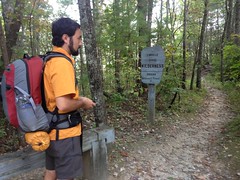
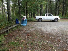
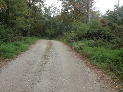
We parked at the information cabin.
We needed a permit to camp in the gorge on Friday or Saturday. You could get permits there, but not until they opened at 10.
We had a half-hour or so to kill, so we got dressed, checked our gear, realized I needed batteries, drove to the nearest store for batteries, drove back, and waited.
At about 10:10 we started wondering why nobody had yet showed up to open the cabin.
Hmmm.
As it turned out, though both of us looked at the sign with the hours posted on it, neither of us noticed the Friday/Saturday-only qualification.
They were only open on Friday and Saturday. It was Thursday.
Woohoo!
We hadn't made a solid plan yet but not being able to get a permit to camp in the gorge proper would certainly have an impact. We started thinking about it.
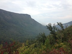
There are two sets of trails in the area - the set around Linville Falls, way up at the head of the gorge, and the set that leads all the way down the gorge itself.
Whatever we ultimately did, we definitely wanted to see the falls, so we deferred development of the larger plan, drove down to the falls-area, and ran around up there for a while.
The trails around the falls appeared to get a lot of traffic. Most of them appeared to been roads at some point too.
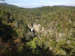
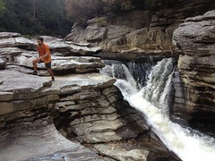
But, if the trails were less than spectacular, the falls itself made up for it.
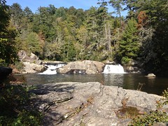
The upper cascade was only 6 or 8 feet high but it dumped into a huge pool which then poured into a raging chute...
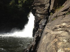
...and over a yet unseen cliff.
By hiking out to the ends of the other trails on the area, we got to see that cliff though and got better and better views of the lower cascade as we hit each overlook.
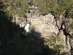
To get a really good look though, we, unintuitively, had to hike up away from the falls and back down on the other side. I wouldn't have even guessed that there were trails over there though, it looked like a hundred feet of sheer cliff.
It turned out that there were actually some really nice trails over there, though one of them had a very steep and rooty section that confused just about everyone on the way back out.
The views of the falls were exactly what I'd hoped for.
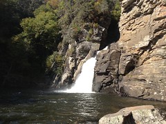
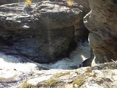
With a little boulder hopping, we were able to get pretty close.
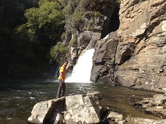
With a little more, we were able to get VERY close.
The pool below the falls was deep and there were cliffs of various heights from which to plunge.
If there hadn't been signs saying don't, I definitely would have.

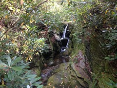
As if the one massive falls wasn't enough, there was a little one on a feeder stream nearby as well.
So, what to do now? We'd seen all the touristy stuff. It was noon. We needed to eat and we needed to make some real plans.
After consulting several maps and Kirk's Hiking North Carolina book, it all seemed to just come together.
We would drive back to the information cabin, walk up the road a little, drop down into the gorge on the Pine Gap Trail, hike south down the length of the gorge (11 miles or so), pick up the road at the bottom, take it to the Mountains-to-Sea Trail, and then take that back north, cross back over and take Pine Gap back up. We had four days. Well, three and a half, and maybe 30 miles. No problem, right?
Riiight.
Since we had to drive anyway, we first drove back to that restaurant for lunch. "That restaurant" being Famous Louise's Rockhouse which sits on the intersection of Avery, Burke and McDowell counties. Literally, the cash register is in one county and the bathrooms are in another.
Louise's deserves to be famous though, independent of it's geographical weirdness. I loved everything on my plate. To me, home-cookin', or anything like it, generally tastes like butter, faintly flavored with chicken or flour. There are notable exceptions, like the Cracker Barrel in Cumming and anything Ginny cooks at Mulberry Gap, but I'll have to add Louise's to that list too now Even their biscuits were perfectly unbuttery and delicious.
Lunch accomplished, it was time to really get down to business.
Into the gorge.
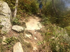
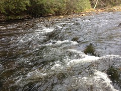
The initial descent went by quickly. It was steep and reminded me of Old Butt Knob, but not nearly as rough and not nearly as long. Right away, we were on the river.
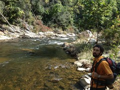
This looked right on the map, there was a guy relaxing in a hammock right there, and a trail led down to the rocks. There was plenty of evidence that people went that way, and we followed their lead.
We passed several small, but still fairly spectacular falls...

...and kept picking up bits of clear trail between the boulders.
Everything seemed to be in order until we ran right up against a cliff and didn't see any way to keep going further
The map made it look like we should have run into a set of switchbacks somewhere, leading up off of the river.
We backtracked a bit but didn't see anything distinct. There were no visible peaks or other features to get a bearing against so we couldn't be sure how far downriver we were from where we should have seen them.
Eyaaah.
We appeared to be in good company though. It looked like lots of people went this same way. Eventually we found the spot that those people generally seemed to try and get up and out. There were clear footprints and it looked like it might even be a trail.
Maybe.
No.
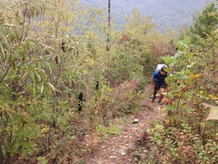
It quickly became nothing. It was a dead end, but apparently a popular one. The real trail had to be uphill somewhere though, and after some fairly rugged bushwhacking, we eventually found it.
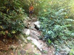
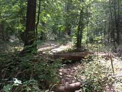
As it turned out, the trail itself wasn't materially less rugged than that bushwhacking we'd been doing. It was more clear of brush, but it consisted almost entirely of short, relentless, rough, rocky and rooty climbs and descents. I doubt there were more than 100 feet of flat at a time, for miles.
We moved surprisingly slowly, climbing up over a little ridge, cutting across a tight bend in the river, and eventually descending back down to another beautiful little waterfall.
We took a short break there.
I'd recognized most of the local flora so far. Georgia and North Carolina share quite a bit, but down along the river there were tons of these scrubby little bushes, covered in berries.
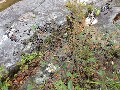
No idea what those are.
Edible? If so, I could have gorged myself on them.
The last time I was in Louisiana, there were equally prolific berries around Caney Lake though and they turned out to be Buckhorn or something, a powerful laxative. So, you never know. Even if something isn't poisonous, it could still be pretty bad.
There were these odd ferns too. Not cinnamon ferns, though we saw lots of those too. No idea.

We had a long way to go, so I quit looking at plants and we got back in the trail, which didn't ease up at all. It was definitely a Class 1 trail. Roots, rocks, encroaching vegetation, downed trees, you name it. Challenging, to say the least. Had the weather been wet at all, it would have been infinitely more slow-going and probably a bit dangerous.
Several times we ended up off-trail on some little spur that had apparently been created by other people making the same wrong turn.
We'd usually get back on track after a minute or two, but once or twice we had to backtrack, try again, backtrack again, try again again... It reminded me of the maze solving algorithm they teach you in Computer Science. I felt a little like that digital rat.
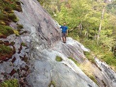
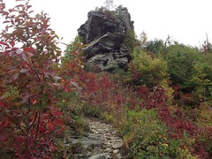
At the Babel Tower Trail, we could vaguely make out a strange-looking rock formation through the trees to the east, and with a name like Babel Tower, we figured it might be pretty awesome and dropped our packs to check it out.
The formation was indeed, a towering ziggurat, but rocks overhung, all around the edge, and it didn't look like there was any way up, or at least any way that I'd be able to get up.
We looked and looked though, and eventually found a route.
Getting to the highest point required a short leap across a deep chasm, which looked easy enough, but the leap back looked exceedingly sketchy without rope or some contraption so we left that for next time.
We did get up on top of what I assume is the tower itself though.
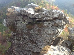
And the view was amazing.
We had a long way yet to go though, and we didn't linger.
Looking at the map, we were surprised yet again by how little progress we'd made. The trail had been substantially more arduous and slow-going than it had appeared it would be.
We pressed on.
Shortly though, we encountered some wildlife.
I'm not sure what kind of snake it was, but it had a very red belly, so maybe a red-bellied water snake, if they're even found that far north.
We hadn't seen much of anything else. The river had tiny fish in it. There were trillions of lizards and skinks, but that was about it. Not even any squirrels. How can it even be "the woods" without squirrels? Seriously.
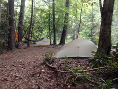
Eventually the trail wound around back down to the river's edge and we started seeing campsites. The first had a 5-person tent set up and a grill over the fire with a pot of coffee on.
No one was around but I thought I could make out movement inside of the tent.
We looked for a spot nearby for ourselves but nothing looked good and we kept going.
I think we found 3 or 4 more potential sites before picking one but the one we ultimately decided on was great. There was just enough space, good river access, and a well-established fire ring.
We collected fire wood then went down to the river to wash up and tank up.
While down there, we noticed a decent sized trout hanging out under a nearby rock. I'd seen Bear Grylls sneak up on a trout once and just lift it out of the water. Dude, if I could do that, we'd be eating in style.
I walked over slowly, put my hand in the water about 4 feet away, very slowly moved it toward the fish, and then just lifted it out of the water.
I couldn't believe it worked.
I second later, I saw why it might have though. The trout had shredded fins with little white growths all over them, and a large pink growth on one side. Poor guy, he wasn't doing well at all.
Still though, pretty crazy that I was able to catch it.
Fish are slippery though, so rather than handle it for too long, I chucked it up onto the rock that Kirk was sitting on, only to discover that he was actually sitting on a rock behind the one I'd tried to chuck it onto and I'd actually chucked it between the rocks, back into the river.
Just as we'll though, we wouldn't have eaten it, and thinking more about it, I'm not sure that I wouldn't have needed a valid NC fishing license to eat it. Technically, I'm not sure even catching it was legal. Does grabbing a fish with your bare hands count as fishing? I dunno.
It would have been cool to get a photo though. I do regret that.
So, no fish, but we still had plenty to eat.
Kirk had Clif Bars, Mountain House meals, candy, coffee and Gatorade.
I had MetRX Big 100 bars for breakfast, instant potatoes for lunch, pasta for dinner, beef jerky, craisins and jolly ranchers for snacks, hot chocolate and Gatorade to drink.
Plenty of calories.
Actually, for the first time ever, I had more calories than I needed on a camping trip.
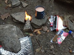
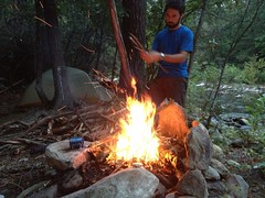
Kirk forgot his spoon so I loaned him mine. He cooked first, then built the fire while I cooked.
We sat around the fire until about 10. There was no chance of rain that night so I just slept under the stars.
The next morning I woke up to a pair of ladies walking by with a dog. They waved and said hi but otherwise kept moving.
We got moving soon too.
The trail let up a bit at first. There were long sections that I probably could have ridden my bike on, but eventually it returned to its former character.
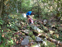
There were several boulder fields that we just had to divine our way through.
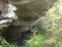
There were lots of these massive rock overhangs too.
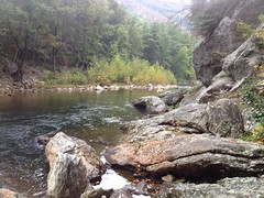
At the intersection with the Spence Ridge Trail, we took a little side trip down to the river.
We'd passed locations where trails allegedly drop down into the gorge from the east, but with no bridge or other landmark, it was nearly impossible to see them from the west side.
Spence Ridge had an actual footbridge though.
How could that be?
Linville Gorge is a wilderness area and thus supposedly devoid of permanent structures, unless they were grandfathered in from before it was declared Wilderness, like the Blood Mountain Shelter in Georgia for example. Maybe that was the deal here too though. We saw remnants of what might have been an older bridge beneath the new one. I'd like to know the history.
I'd wanted to swim in the river up by the falls but there was no way. Here though, it was ok.
Kirk swam here.
I swam here.

It looked deep and I'd hoped that it was deep enough to jump off of the rocks but no luck there. It was surprisingly shallow; fewer than three feet in most places.
The water was devastatingly cold too. I love 50-odd degree water when it's a million degrees outside, but when it's only like 65 degrees, no no no. Horrible.
We saw another hiker there. She had two dogs with her that were very excited to see us until they got within 10 or 15 feet, then they weren't so sure. It was a lot like how Sophie is with dogs. Funny how that goes both ways.
There were a few more steep pitches, sketchy traverses, and all-but-innavigable rock gardens but by and large the trail got substantially smoother and easier south of Spence Ridge.
There were still plenty of rock overhangs though.
Literature at the trailhead kiosk had indicated that we should respect these overhangs and the delicate ancient artwork found thereunder.
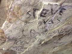
Yeah. Good thing people follow rules.
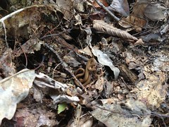
We found another snake too.
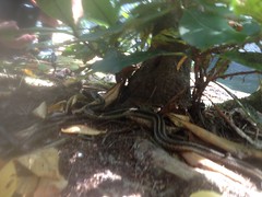
Yellow Rat Snake? I think they have stripes like that. I'm not sure though.
The trail became shallow and clear and we started making really good time. Eventually it joined an old roadbed and we started making REALLY good time.
We ran across two former Wilderness boundaries. The posts for the USFS signs were still up. One even still had the logo on it.
The trail diverged from the old roadbed at a strange formation. The river made a loop to the east but appeared to be trying really hard to cut a channel across the loop. The road seemed to disappear into this channel.
We followed the trail but after a while it didn't seem right. Kirk's book showed it joining up with a road at the south end of the gorge and it wouldn't likely diverge from the roadbed just to rejoin it later.
You never know though, so we followed it.
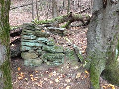
There were several of what appeared to be old, busted up chimneys back in there.
Ultimately the trail just ended at the river.
We did a little boulder hopping but it wasn't like earlier and we ran out of boulders immediately.
This can't be right. We must have missed something.
We checked the map. The map showed the trail crossing the river.
Long story short, we studied the map, backtracked, searched, didn't find any semblance of a river crossing, triangulated, and eventually just crossed the river and walked inland until we found an old roadbed.

This took a long time and burned a lot of energy.
Once again though, we were on the path and on target to hit the Mountains-to-Sea trail within the hour.
Or so we thought.
Upon crossing a little streaming the road, I barely noticed a flash of orange out of the corner of my eye.
Posted. No Trespassing. Private Property.
There were actually three different signs and all three were positioned such that they could not be seen directly. They were facing the right direction, but the trees they were stuck to were directly behind other trees. It was luck we noticed them at all.
We checked the map again. Down where we were, the background was brown. This apparently meant private property. That's a new one for me; private property within a Wilderness area. I didn't know that was even possible.
Jeez, what could we do?
The Mountains-to-Sea trail was straight ahead, less than a half mile away but we couldn't get to it. The road was private. The river itself was even private so we couldn't just walk downstream. It was getting late, the terrain was too steep and dense to bushwhack through in any reasonable amount of time. We were getting kind-of smoked too.
We debated our options.
Then we got distracted by this newt...
(seriously, we did)
...then we debated our options again.
We had a day and change left. We couldn't make it back up the gorge trail in that time. Assuming the Mountains-to-Sea trail was cleaner, like the section in Shining Rock had been, we could make it back that way in time, but the Mountains-to-Sea looked inaccessible. The only way to get to it was to backtrack, cross the river and find one of the trails that heads east up out of the gorge. Finding one of those seemed like it would take a lot longer than we had left before dark.
Our best option looked like backtracking to the last west-bound trail (the Pinchin Trail) and camping nearby, then taking it up and hiking out on the road the next day.
Without a permit, we weren't supposed to camp down in the gorge, but we weren't confident we could get up to the road before dark, or find a place to camp once we did. Given that we'd only seen 5 people in two days, we suspected that the walk-in permits hadn't been consumed and that an explanation of our circumstances might get us out of any trouble we might find ourselves in, should anyone even ask.
So that became our plan. We figured we'd try to follow the road back the other way too, just to see what wrong turn we made.
The road was easy to follow for a while, then suddenly became inundated with deadfall and rock.
Closer to the river it disappeared entirely under a deep sheet of babyheads.
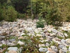
A massive flood must have ripped through the gorge sometime fairly recently, leaving all of that in its wake. Maybe one of the last decade's hurricanes was involved. Ivan was especially tough on Pisgah southwest of there, maybe he was the culprit.
A set of cairns marked the route and we followed it to the river where we crossed at a more shallow but substantially faster moving spot than before.
It looked like that new route that the river was trying to cut was also the route of the old roadbed. Maybe the presence of the road in that location had even encouraged the river to try to go that way.
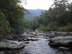
We made camp just south of the Pinchin Trail.
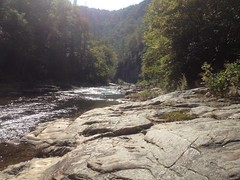
The views from the river there were amazing.

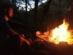
Kirk was again, master of the flame.
We didn't find any more trout but Kirk did find this gigantic bullfrog.
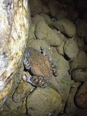
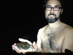
Good thing for it we weren't hungry.
The forecast called for a 30% chance of rain but some clouds had rolled in just before dark and I set up my tent, just in case.
Kirk was trying out a new hammock, but he set his tent up too, again, just in case.
I slept like the dead but several dreams into the night it started sprinkling. I expected to hear Kirk scrambling madly for his tent but I didn't hear a thing. Later it really started pouring, but again he was silent. Eventually there was thunder and lightning and a torrential downpour. My rain fly isn't 100% waterproof anymore and my bag got dripped on, but not enough to cause a problem if I spread the drips out every so often. I had my clothes, shoes and hat in my bag with me, but my pack was hanging from a tree nearby and I could only imagine the drenching it was getting.
Still though, I was warm, cozy and relatively dry, and I slept like that dead I mentioned earlier again, for the rest of the night.
In the morning, the rain had stopped but the sun wasn't out. I found out that it had started sprinkling earlier than I'd noticed and Kirk had gotten in his tent then.
We had breakfast, packed up and began climbing out.
The gorge trail appeared to have been worn in rather than constructed, but it was an undulating sidehill through incredibly rocky terrain and except for a few locations, couldn't have been more ideally placed if it had been cut on purpose.
The Pinchin Trail, on the other hand appeared to also have been worn in, though directly up the fall line, along the most direct route, on whatever ridge was easiest to navigate by. Lack of traffic was all that could account for its decent condition.
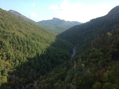
About halfway up, we got into a zone that appeared to have burned recently and again, were treated to spectacular views both up and down the gorge.
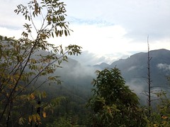
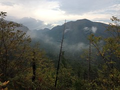
It looked like most of the forest, just under the rim, had burned for as far as I could see.
The trail only got steeper and steeper, and without the protective canopy, started becoming very trenched and much more difficult to climb.
Kirk hadn't really woken up yet either and he wasn't having a really hard time.
Eventually we neared the rim, encountering rock formations like I'd expect to see out west rather than in North Carolina.
And at great length, we reached the top.
As the trash can had been overflowing the night before, somebody had set down their empty beer bottles on the fence and they had collected a half-inch of water in them. Considering that the mouth of the bottle is substantially narrower than the bottom, conservatively we'd probably gotten an inch of rain the night before. That's about what it had felt like too.
An older gentleman was sleeping in his truck and got up when he heard us bumping around. We talked with him, for probably 20 minutes. He was up scouting for bear sign. The season was still two weeks away but he wanted to get a good start. I love running into people that are out in the places I go but doing something else. I love just getting their perspective. I'm always surprised by how different we all are, but then also by how much we have in common.
All that we had left was to march back to the cars on the road.
If the weather held out, we could drive to Wiseman's View and Table Rock and do the short hike up to The Chimneys later on. Maybe we could camp in one of the sites along the road that night too.
We began our march.
At Connelley Cove we ran into two guys that had hiked down the night before, camped, hiked back up, and were waiting for their ride to pick them up. They were friendly and we talked to them for a while before getting back in the road.
Shortly, it began to sprinkle, then drizzle, then rain. Then it started to rain hard.
We had about 4 miles to go. I had warm and dry gear in my pack, but I really didn't want to stop and change unless I could dry off too and it wasn't cold enough to matter yet. We figured we'd stop at Wiseman's. There was a bathroom there. Maybe we could cook some lunch too, I was starving.
A few minutes later a truck pulled up and the driver offered us a ride. It turned out to be the parents of those guys we'd seen earlier. Good thing we'd stopped to talk with them, eh?
They gave us a ride back to the cabin. The dry, heated cab of their truck was luxury compared to the downpour we'd been walking in outside.
The rain stopped and started again over and over in the way back. The gorge itself was socked in with fog and the forecast just called for more of the same.
There was no particular value in hitting any of the overlooks, there was nothing to be seen. In the end, we just headed back to Louise's for another good meal and called it a trip.

All right!
This trip had just about everything that I hope for. We saw amazing spectacles of nature. We walked until we couldn't walk any more. We struggled on arduous trail. We covered long miles on easy trail. We ate well. We slept well. We had roaring fires. We had perfect weather. We had terrible weather. We got off track. We had to adapt our plans and reaction to significant, unforeseen obstacles. We walked. We ran. We climbed. We swam. We were hot, cold and comfortable. We enjoyed ourselves.
I really couldn't have asked for much more.
One of the big wins on this trip was the Pearl Izumi running tights. I'd bought a pair just prior to leaving and wore them exclusively, the whole time. Heck, I even slept in them. They don't chaff. They wick moisture. They dry fast. They don't catch on anything. In combination with a sleeveless summer base layer, it's like just having slightly tougher, more sun-resistant skin, and they were comfortable, even just standing around, down into at least the low 50's and probably lower.
Another big win was those barefoot running shoes I'd bought a while back. After two and a half days of steady hiking on exceedingly rough trail, my legs were tired but my feet felt insignificantly different than they did before I started. Classically, I'd be dealing with blisters, jammed toes, toenails digging into other toes, worn out arches and shin splints. None of that! Who'd have guessed that removing all support was the key?
A small failure for the trip was using Ezbit tablets in an alcohol stove. They don't get enough O2. I'll have to work on that a little.
Oh man! The Linville Gorge is amazing and there's so much left that I haven't seen. I hope I can get back there again sometime in the next few years. Maybe me and Kirk can go again together.


