Wednesday, June 6, 2018

Sawnee Mountain

When the girls were young, I took them up Sawnee Mountain to the Indian Seats nearly every week, to "see the whole world". I'm not sure about Iz, but Sophie remembers it fondly. Her 16th birthday is coming up next month, and to celebrate, she wants to take a group of her friends up to the Indian Seats too.

She has a plan lined out for the day, but last weekend she wanted to scout the trail. It's been years since we've been up there, and for all we knew, it might have been rerouted, closed, or who knows what.

Oh, contraire!

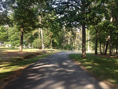
It was more popular than ever! The parking lot was completely full, and the county had even built a second phase on the other side of the road.

Ha!

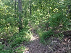
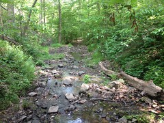
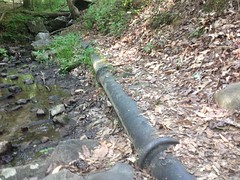
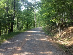
The trail itself was a little different though. The soil is mainly decomposed granite, and it was originally built as an outsloped bench cut, but it was a little wide - between 4 and 6 feet in most places. As a result, it doesn't drain quite as well as it ought to. In some places, it was chunky on the upslope side and sandy on the downslope, and you could see where people have been avoiding both and widening the trail. They say hiking trails are especially susceptible to creep. I'd seen very old evidence of it on some trails in the NF, which appeared to have crept and crept over the years before finally settling in, but I'd never seen it in action until this past weekend.

Sophie on the Indian Seats Trail

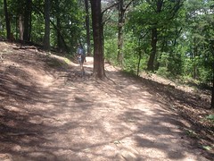
You can kind-of see the creep in this photo. The original route was to the left of the tree, but it's gotten chunky and the popular route these days is to the right.

But enough of that nerdity.

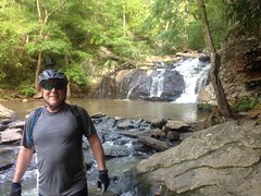
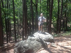
The girls always liked to climb on these rocks, near the bottom of the trail. Sophie recognized them right away and here she is standing on that same rock 11 or 12 years later.

Sophie on a Rock

On the way to the top, we must have passed a dozen groups coming up and down. Way back, we might have seen one other couple all day.

It could almost be described as crowded at the top, too.

We had to wait our turn at the Indian Seats.

The Indian Seats

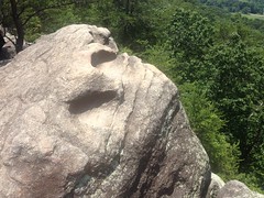
But we did, and we got to sit in them, once again.

Sophie in an Indian Seat

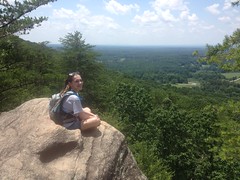
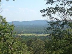
The whole world was still there too.

View from the Indian Seats Sophie at the Top of Sawnee Mountain

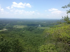
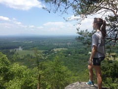
It was a little too hazy to make out the Blue Ridge, but the Burnt Mountain system was pretty visible. I used to know the names of the peaks in the distance, but standing there, I couldn't remember them.

Awesome. It didn't look like her plans were in jeopardy, except maybe from crowds.

The hike back was slightly more interesting than the hike up. They'd rerouted the trail a bit and my map wasn't exactly accurate any more. Fortunately, every major corner now has a map. Apparently the Indian Seats and Laurel Trails had been merged into one trail, and the Interpretive Center Trail had been renamed Laurel Trail Spur. I thought this was funny because there was no actual Laurel Trail to spur off of any more.

I think it took us 45 minutes to hike up, mill around a bit, and hike and back down. We figured we should double that for the group, and add some extra time for snacks and fooling around at the overlook. Even with those numbers though, her timetable for the day ought to work out fine.

Excellent!

On the way home, we stopped by the Dutch Monkey (of course) and nuked our respective pancreata.

Insulin response never tasted so good!

Cochran Mill

Isabel graduated High School a few weeks ago, and my parents were in town all week. We were super busy with various graduation-related festivities, so we didn't get to do much riding, but we did manage to sneak out Friday afternoon and get in a ride at Cochran Mill.

My Dad even got some GoPro video of a good bit of the ride. I realized I'd never seen myself ride before. It was really weird, and it reminded me of something I talking to Sophie about a while ago. You have a group of friends, and if you imagine them, that image is your concept of the group. But! When each of your friends imagines the group, they see you as part of it. You are part of their concept of the group. In stark contrast to your concept, which doesn't contain you! Seeing myself riding was like that.

We had a good time. Lots of fun. No crashing. My Dad had never ridden there before, so he loved it. Oddly, it didn't occur to me to take any photos though, and my Dad didn't post his video on YouTube or anything, so I don't have much to show for the ride.

We did stop at Cochran Falls though, and I did get a shot of him there.

Dad at Cochran Mill Falls

So, at least there's that.

One funny thing too... Riding across the parking lot, a lady in a car was driving out and asked us where the falls was. Well, there are like 5 falls, but I figured the one she must mean was the big, primary falls, that used to drive Cochran Mill proper. We gave her directions and took off riding. Later, as we were riding down to the creek, she and her buddy were climbing the road back up to the parking lot. They were both completely soaked, had clearly found the falls, and had clearly been enjoying it for that entire time.

Success!

I was glad to have been able to help. It struck me too... Over the years, I've given countless people directions to this or that, but very rarely been able to verify that my directions did them any good. It was pretty validating to see that they had.

I hadn't thought about it until now, but I guess it was a day of rarities.

Berry College

I've ridden my bike at Berry College a dozen times, and during those dozen times, I noticed a good many side trails. Some of them are signed, and I've seen people hiking them, but I don't know what the rule is for riding on them. They definitely aren't on the bike trail map, so I always avoided them, but a few weeks back, me and Billy got up there to check some of them out on foot.

We parked at the horse lot on the north side of Lavender Mountain and approached from that side. There's an old roadbed leading up the mountain from that lot. Like the rest of the trails, nothing in the field indicates what you can do on the trail. It's on the horse map, not on the bike map, but horse trails are generally ok to walk on, so we went with that theory.

The road itself was braided wildly. It looked like it had been rerouted several times, but the reason was unclear. The trail lay on the steepest route, which was in fine shape. Whatever the reason was for the reroutes, it wasn't because the old route had gotten worn out.

When we reached Redmond Gap, we hung a left and carried on until we found the first of the side trails.

Tightrope

There are signs with arrows indicating that it leads to "Tightrope" and the "Old Mill", but the trail itself isn't named on any map I've ever seen.

It dumped us out down by the lake. We proceeded around its perimeter until we found another trail, and took it up and over a gap between the main ridge and some little subsidiary knob. The trail eventually ran down along some little creek and crossed it several times.

Some Creek

We ran into some hikers coming the other way near one of the crossings, but we also ran into something much more interesting after another crossing.

Timber Rattler

I was a bit ahead of Billy, and while I waited for him to cross, that snake started crossing the trail between us. When it saw him, it stopped, and when he saw it, he stopped too!

Billy really doesn't like snakes, and really wanted to find a good, wide route around that one, but it turned out that he didn't have to. We just waited a minute for it to decide to keep moving across the trail and down into the creek.

Farther on this old pipe was partially exposed on the east side of the creek.

Old Mill Feeder Pipe

And, even farther on we ran into that Old Mill that the sign on top of the mountain had mentioned.

The Old Mill

The mill features an unusual water supply. Water actually climbs that tower behind the wheel before spilling over it. That pipe we saw earlier starts higher up the mountain than the top of the tower, so it's able to push water up the tower. I read somewhere that it's the tallest such overshot wheel in the world, or the US, or something.

Maybe it says that on one of these historical markers...

The Old Mill Plaque The Hub Plaque Berry Schools Old Mill Historical Marker

Just east of the mill, a trail leads back up the mountain. And, my goodness, it's steep.

The trail is called the Longleaf Trail because of all of the Longleaf Pine in the vicinity. I don't remember whether that stand was restored, or just still stands from way back, but either way... Longleaf Pine, everywhere.

There were a couple of clear spots too, with some good views.

View from Longleaf Trail

We ended up on Mountain Goat, I think. The last time I was up there, Redbud was blooming all up and down the south side of the road. The bloom was over by the time we got up there, and I kept looking for those heart-shaped leaves, but nothing jumped out at me. I think I remember only seeing one. It was weird, given the significant abundance of them I'd seen before.

We took some trail that seemed like it might have been a former route of Mountain Goat. It dumped us out on the Old Mill Road...

Old Mill Road (Paved)

Which led back to the House o Dreams Road...

House o Dreams Road

Which took us back to Mountain Goat.

A guy on a bike was climbing, very slowly, behind us for quite a while. He eventually passed us, but we caught him again a few hundred yards later. I felt bad for him, because after passing him a second time, he never caught us again. A lady on a cross bike came crushing past us at Mountain Goat though, looking really strong, in sad contrast to that poor guy.

Really, in contrast to us too. We were ready to be done, and basically just marched out. There wasn't too much more climbing between there and Redmond Gap, but even the flat was tough, because, for some reason, I was developing a blister on my right foot.

Come on!

Since switching to barefoot shoes like 8 years ago, I had yet to suffer a single blister. I didn't even realize that was what it was at first. I thought I had something in my shoe. It looks like the upper layer of the insole has gotten detached from the other layers, and can now slide around a bit. I guess that's what caused it. These shoes have been a nightmare since day one. I'd finally modified them enough that they didn't bruise me every time I'd go for a walk, but it might be getting to be time for some new ones.

On the way back home, we drove past a few neat things. There's a Family Guy themed convenience store somewhere between there and Rome, with giant pictures of Peter and Stewie on their signage. There's also an old Scottish Inn that some independent owner bought and renamed "Cottis Inn" by painting over the S and h. I joked that he should have turned the first t into an i, making it "Coitis Inn", which, though misspelled, would almost certainly describe its present function in the community.

We tried eating at Gondolier Pizza in Rome. I think I ate there after a big road ride with Travis and Russel once, and I remembered it being fantastic. Sadly, it was under new ownership or something, and not as good as I remembered.

You can never go home again, they say. Rome isn't technically home, but whatever. Something like that.

There are plenty more trails up there. We have plenty more to explore, and I imagine we'll get to it soon enough.

I may be wearing a new pair of shoes next time.