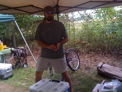
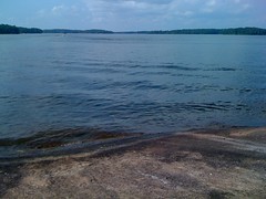
Iz had a lot of homework tonight so me and the Gerch went fishing by ourselves.
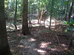
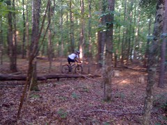
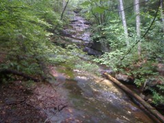
Man, look at that trail. I've still got trail assessment on my brain.
We showed up about 10 minutes late. We got hit after hit for about 5 minutes, then nothing. Well, not quite nothing.
We caught 3 like that one. Sophie caught one holding my rod while I was working on hers. Her reel fell all apart. We got over a year out of her Spongebob starter kit. I guess that's a good run.
I tried to get up at 8 this morning. I really tried. But my body just would not do it and I reset the alarm for 10:30. I did succeed in getting up then, and the girls had just woken up as well. We met the E at Atlanta Bread for an interview with Joe Polk of MTBCast about the Trans North Georgia Mountain Bike Adventure, which is just around the corner.
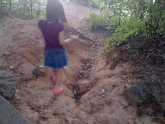
The girls sat at their own table and were outstandingly well behaved. They've really been exceeding my expectations with that kind of thing lately. It was cool to look over at them, sitting across from each other, eating, chatting, swinging their feet, all by themselves, not grown up yet, but making a lot of progress.
Joe asked us questions and Eddie responded coherently and informatively. Until I hear the podcast, I'm going to assume that I spoke too fast, rambled on too long and forgot to say many important things. L'esprit d'escalier!
TNGA starts in less than a week though, Woohoo!
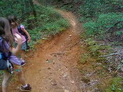
Post-interview, me, Ed and the girls drove up to Bull Mountain, or more precisely, the Turner Creek area. We've got some business to attend to up there. While marking the Fool's Gold route, Eddie and I both became concerned about how much wear the trails had sustained in the last year. He spent the better part of two days clearing drainages and nicking turns prior to the race, but he could only do so much. During the race it rained torrentially and riders reported enduring the worst conditions of their lives. Eddie talked to some forest service folks and some SORBA folks that have been involved with the work that's been done since the Bull/Jake Trail Assessment. A plan was worked up to reroute or repair some of the trails out there, some of that work has been done, some got postponed, some is scheduled for this fall. Nobody's been motivated to do too much maintenance until that work is done. Eddie and I are though, especially on the trails that we expect will remain open and especially on the ones at lower elevations that could have a more significant impact on the watershed.
But, before we jump out there swinging pickaxes. I'm not taking anyone's word for it. What is actually going on out there? Let's find out...
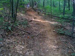
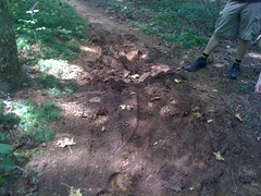
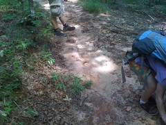
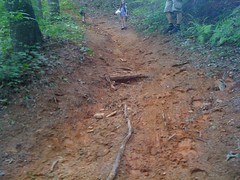
The Turner Creek Trail is a fast, flowing mile or so of singletrack running from FS28A near FS77 down to a food plot access road. Blogs and forum posts reported mud everywhere and generally terrible conditions on this trail, in particular. Every rider rode this section of the Fools Gold route. It seemed like a good place to start.
At the corner of FS28A, we noticed right away that water appeared to be flowing from the road down onto the trail. Prior to the Bull/Jake Assessment, under the assumption that volunteers would be responsible for maintenance on Bull/Jake going forward, the USFS got Woody Keen to teach a class on trail building and maintenance, including how to identify problems and what to do to fix them. I learned in that class that a soccer ball is a good analogue for water. Where the ball goes, water would go, generally. Where would the ball go?
Right down the trail.
Where would it stop?
At the very bottom of the hill, on the trail. The ball tries to get off the trail several times, but there's a little berm on the edge, holding it on. Water would do the same thing, picking up and carrying sediment down the descent, and dumping it when it stops. There are no tire tracks on the hill, the trail surface is solid there, but it's soft at the bottom from all the deposition. This is not the end of the world, any rider can manage this, but lets say last year it was solid and fast all over, and this year a rider rolls down the hill, hits the softness, loses speed, loses traction, leaves a track, has to climb the next hill and goes home compelled to troll for a flame war on the internets... "Bull Mountain sucks! Turner Creek used to be my favorite trail, but I got out there last week and it wasn't even rideable!" ...drawing the classic... "Sorry n00b, I guess Turner Creek isn't sanitized enough for you, some of us real mountain bikers like to ride real trails, maybe you should stick to the road, shaver!" ...and, of course, the even more classic... "Yeah, those f'n horses just tear up everything, who even let them on our trails?!" Then I read all this, lose faith in humanity and have to cry myself to sleep on my gigantic pillow.
We just can't be having that.
But I digress... our experiment revealed chaos at work. The ball doesn't always roll down the hill, even if you start it in the same spot.
We tried it several times. It was 50/50. I was pretty surprised the first time it didn't go down the hill, as you can hear in the vid.
Nicking the pile at the bottom would help; water wouldn't stop until it's off the trail. Deberming the hill would help even more; water would run off before it even hits the bottom. Neither is a permanent solution, but both are easy to do and would restore the character of the trail for many years. As we walked the trail, we realized that in general, the same solution applied to a lot of it. Deberm the hills, nick the bottoms.
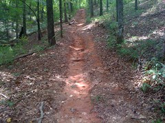
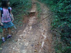
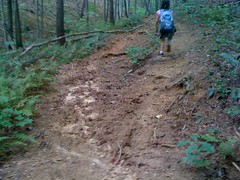
But it wasn't that simple everywhere. This is the second hill.
You can see the original line to the far left, and over the years, as the roots were exposed, the trail has crept to the right. At the bottom there's a relatively hard turn, deep with sand. There is a clear trail forming from this turn up to FS28A, presumably because this hill has become too dangerous for some horses. This is a fun descent and a challenging climb, but it's not sustainable. It's been changing, continues to change, has motivated the establishment of a user-created trail, and the sand at the bottom is lame. We didn't have a clinometer, but it's probably steeper than half the backslope. Water won't flow across the trail here, only down it. Deberming won't help. We played with the soccer ball all over this hill. Rolling dips in key spots would channel water off of the trail. Rock armoring would mitigate the erosion up around those roots. Short of a reroute, that's what we could do.
And there's this kind of thing...
This is a steep fall line trail that has worn in until it's below grade. It's stable at the top, on the hill it's loose, and predictably, at the bottom, there's another pile of sand. If I remember correctly, this is where the singletrack joins an old roadbed. From the other direction, the road continued down to the creek and the trail diverged to the left, straight up the hill before picking up the sidehill. The length of it could be armored with rock, or gravel. That's about it. Any repair on this hill will be a lot of work.
This hill is an example, though. A warning. Without some kind of attention, a couple of the hills out there will start looking more and more like this. Some faster than others, but we have an opportunity right now with most of them.
There were one or two places where the low spot between two hills crossed a dry prong. They were messier than other low spots:
Can't nick them out, The trail would need to be built up with a bridge, a puncheon, rocks... sticks? People have been throwing sticks down for years. It looks terrible, but there are only a few of these, they're only bad after it's been raining and one of them does have a bridge. From a rideability perspective, I wouldn't mind leaving them alone, but they could be built up.
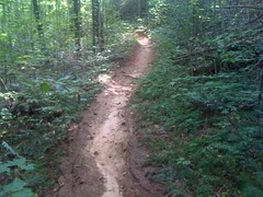
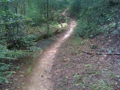
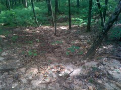
At a point, the old Turner Creek Trail diverges to the left and runs through a low, flat spot. I explored that trail last week. The newer trail continues along the contour, and appears to have been built with IMBA practices in mind, though I imagine it must have been built before they existed formally. This section of the trail was in pretty good shape.
It was outsloped with grade reversals. We even verified in several locations that it didn't even need to be debermed. Ideally, this is what water should do, roll right across the trail, even on a descent:
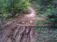
But, then when the old trail picked back up, we found another low spot with deposition:
...and the responsible party.
So, occasionally, we'd run into a problem, but by and large, Turner Creek was like this:
It may be hard to see in the photo, but this is a clean trail descending gradually to a messy low spot with another clean trail ascending gradually back out of it on the other side. Those low spots effect the biggest change in the experience of the trail between this year and last year. None of them were especially close to the creek and the terrain flattens out a lot between the trail and the creek, so I'd expect the environmental impact to be low, if measurable at all, but they're a little sketchy, they slow you down, and they look pretty bad. But on that note, I was surprised. They don't look THAT bad. I'm sure it looked really bad during and right after the race, but a week later, given that there were over a hundred cyclists on the trail in such epically bad conditions, surprisingly few tire tracks were still hanging around, and only in the low spots. If those low spots weren't built up so much, I don't think you'd be able to tell what kind or how much traffic the trail was getting at all.
So what should be done? Well, that depends on your philosophy and maybe your financial resources.
To make the trail hydrodynamically neutral and infinitely sustainable, you hire experts, do a soil analysis, determine the maximum slope based on it's shear strength and the average weight of a heavy horse and rider, go in with a clinometer, flag a new corridor, go back and pin flag the grade reversals, cut new trail with a Dingo, use the old trail where you can and elevate every dry prong crossing with stone until the new trail feels like FATS or Jackrabbit.
To make the trail feel like it "used to" for another 4 or 5 years without requiring much maintenance, I think you do the things I mentioned above and you monitor the bike/horse communities for "rules" vs. "sucks" comments to decide when to do them again.
To take the trail underground, you do nothing, let nature continue to take its course, let riders abandon the trail as it starts feeling lame to them and let more skilled or tolerant riders keep riding it. Eventually "Turner Creek sucks..." but a new equilibrium may form where the winter's duff never really wears away, the trail becomes perpetually armored with sort of a natural kevlar and after a couple of years, some of the ruts even heal, magically. People think Turner Creek sucks and forget where the trail head even is, but you know that it doesn't really suck any more and keep that secret close. It's happened before, but what's also happened before is trails just degrade until nobody can ride them, and we fall back and blame it on horses.
Choose!
Some rumors sort-of, maybe, kind-of allege that the 2010 Fools Gold itself is outright responsible for the plight of the Bull Mountain trails. The Bull/Jake Assessment provides evidence to the contrary, but so does direct inspection. This trail has never been used in a Fools Gold route, but it shows the same kind and level of wear as the roughest trails used by it, except maybe for lower Bull proper.
This is the connector from FS77 that leads down to the southern end of the Turner Creek Trail. Maybe it's technically part of the Turner Creek Trail proper but I always think of it as a connector. Go take a look, water runs down that channel on the left side for the length of the descent, steadily carrying the trail away with it. You can even make out an alternate line where people have started going to the right.
The runoff gets deposited in this corner...
and fans out for a hundred yards into the woods below the trail.
Oddly enough, as chunky as the downhill is, the corner is actually functioning, as predicted by the adage: "Turn the trail, not the water." Almost all of the sediment is getting carried off of the trail itself and down into the draw. There's no running water down there either, it's a dry prong. You can see that the underbrush is suffering though, not much grows in that sand. That's probably not good. With my luck, there's probably a rare trillium that once grew there.
That left hand sweeper leading from Turner Creek down to the roadbed is a bit of a mystery. Despite being a deep trench, it's smooth and clean for most of it's length until it gets a little rooty at the bottom. Clearly, water is running swiftly and directly down the trail, but the deposition at the bottom wasn't as bad as I expected. The remains of old rolling dips along its length could be repaired, assuming that's deemed necessary.
The doubletrack/roadbed was grassy and for the most part, pretty flat. I bet during the race it was muddy because it was so freakin' flat, but the soil doesn't go anywhere. It's just mud and it sits there. The soccer ball just sat there too. There were some small hills, with sand at the bottom. Being a road, there's not much we can do, though I'm not sure we'd really even want to.
I'd lost my glasses out there last week, breaking branches off of a downed tree and today I found them! I've lost multiple pairs of $150 Smiths, but these $25 Performance Bike dork goggles just keep coming back.
"F'n horses!":
Oh, wait, that's a bike-only trail showing exactly the kind of wear that people have argued all up in my face can only be caused by horses. I've seen it on hiking trails too, at Elachee. Water just does this when it runs over a root, or backfills a water bar, or something like that. This trail is on an old roadbed and runs kind of sideways down a hill from the road to a bridge across Turner Creek, but it's probably too steep (more than 1/2 the backslope) and has overwhelmed the rolling dips constructed in it. They could be repaired and they'd probably last a couple of years.
The USFS representative had mentioned to Eddie that after the Fools Gold, he was surprised, the only really bad spot he saw was here on the bike-only trail where silt had been flowing directly into the creek:
It looks like somebody put that log there as a silt trap and it's kind-of working. Getting water off the trail up the hill from here would work even better.
The Turner Creek Road Bypass looked a lot like the good section of the Turner Creek Trail. The ascent from the creek had the same problems as the descent, where it followed an old roadbed. Once the trail got off of the roadbed, it mostly just needed deberming and nicking. There was one boggy spot that could be built up and a short hill where the right side runs over rock, but the left is getting soggy. The left side could be armored, or blocked off.
We'd parked Ed's truck on FS28-1 and shuttled over to FS28A in my truck. Now, back at Eddie's truck we had to pile in and shuttle back to mine. He generally keeps the seats down though and fills the entire back with bike stuff, so it took a little work to make the back seat available for the kiddo's, but we got it done and headed back.
On the way back we decided that we had time to check out the Moss Branch Connector. We used it in the race too, and it's always been a rough trail. How would it have fared?
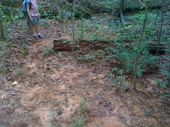
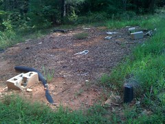
We parked at the ruins of the old game check station. No more Blue Ridge WMA, so no more game check station. They took the entire building, why would they leave these scraps behind?
My theory is that it's cool to leave a little behind as artifacts for future generations. Some day it will be lost knowledge that there was a game check station here and somebody will puzzle over these remains as I have over the various rock walls and bricks I've found way up in the woods. That or they ran out of space in their open-top.
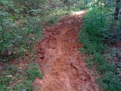
The Moss Branch Connector is busted, I suspect beyond repair.
Trenched out...
and here's where all that trench went.
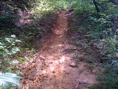
Fall line climb/descent:
I have climbed that before. When it's dry, I can make it.
For the most part, the trail follows an old roadbed. There are ruts and runoff trenches all over. You'd need a bulldozer or a grader or something to fix it. Later on it gets more trail-like, but not entirely, until here:
...where the old roadbed just dead-ends into a draw and what appears to be just a walked-in trail begins. By walked-in, I mean, I don't think any tools created this trail, horses just went that way for 50 years until there was a trail. Roots criscross from one side to the other every 8 inches, with no soil between them and exposed rock juts out all over the place. When it's dry, it's not unrideable, but it's not that fun either, at least not on a bike. It's short from there to the intersection with Jones Creek Ridge though.
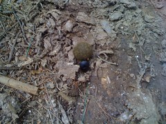
We saw dung beetles having a ball (literally, heh) with some fresh horse droppings.
That pretty much fascinated the girls.
The Moss Branch Connector is the kind of trail that influences some people to categorically accuse equestrians of destroying trails and then accuse me of being a naive northern equestrian sympathiser when I disagree. The trail is very challenging and technical, not unrideable, but trenched, rutted, braided, boggy, rooty, rocky, slippery, too steep, eroding away, wide and generally covered in deep hoof prints. There is no question that horses tear up this particular trail, but Turner Creek, the Bull-Jake Connector and the FS83 bypass don't have any of those issues and horses are as or more prevalent on them. I suspect that the Moss Branch Connector, overall, is just a little too steep to sustain the weight of a horse and occasionally too steep to sustain the weight of anything. It doesn't help that there are no erosion control structures, and also to the untrained eye, the trail doesn't look that bad except where it's really bad, so nobody is discouraged from riding it if they feel like they can get up those hills. Trail science is a new science and still not common knowledge. You can't fault anyone for riding that trail and you can't categorically apply conclusions drawn from it either.
It might be possible to fix the old roadbed with a bulldozer and the singletrack with a Dingo, but it would take that kind of work, and the really steep climbs would just get wrecked again in a year without being rerouted. I imagine it would be easier, cheaper and faster to cut your losses, close that trail and build a new, sustainable one.
We took Jones Creek Ridge and a connector back to Eddie's truck and shuttled back to my truck after that. The kids were wiped out. Sophie had been dragging back, even before we got on the Moss Branch Connector. They'd been helpful all day though, especially with the soccer ball. We drove up around the Winding Stair loop, backwards, collecting any leftover pink marking tape. Some guys were supposed to take it down, but they missed a lot.
On FS80, we ran into an older gentleman who'd double-flatted his truck. I gave him a ride home where he could patch his tire and get his wife to bring him back to his truck later. He lived off of Canada Creek Road. I'd driven, hiked and ridden past his house many times, and I'm sure I've even seen him in his yard and waved. I asked him about those red cherry trees with the smooth leaves. He had several growing across the street from his house. He said they were just wild cherries, and totally safe to eat. Really nice guy.
Finally, we went up around FS141 and examined the trail work Eddie'd done to the Black Falls Trail prior to the race. Some of it had been effective, some of his cuts were clear, some were completely filled in after just a week. Much of the trail there was fine, you couldn't tell anyone had ridden on it. One red clay hill though, leading right down to a creek, was still showing tread marks and would need some work.
It was a long day, but a long, interesting day. There's a contractor that's supposed to do some work in the fall, so we're hoping to find out what all's involved with that and go from there. We still need to take a look at Bull and Bare Hare, but they're lower priority. They have less impact on the watershed. Black Branch is certainly a problem, but it's supposed to get some kind of bulldozing, so we'll wait on that. Same for No-Tell. I'm not sure what the next steps will be, but I'm willing to put in some work days. Right now though, I'm ready to put in some sleep days. Zzzzz.
I had relatively low expectations today. With allergies or a cold or something and spine-crushing neck pain, basically, I planned to show up and limit my losses. I also popped my knee last night helping my wife move a big Corian counter top. But, last night my neck was feeling a lot better, I'm doing OK in the Chainbusters series, Tribble Mill is a fun trail, I'd see some friends, etc.
Right away I ran into Brian Lord! I haven't seen him in years, since the GAP series, or maybe once since then. He's been riding this bike almost as long as I've been riding mine.
I was like "Hey is that Brian's bike? Brian!"
Up from Albany...
Wild Bill Riddle!
Vonnie McClung!
I set up my chair and my stuff under their tent and got to hang out with them a lot today.
Brad Birney was going to help me out again today, but he ended up getting recruited onto a 12 hour team, which was awesome until he broke his bike.
Man, I saw lots and lots of folks I know today. I even met Tim Winters. I only know him from the SORBA forum, and not by his real name, but I've gotten a ton of trail data from him for my trails site. It's funny, I noticed a while back that we end up doing a lot of the same events and I must have seen him, but not known who he was. Hilarious.
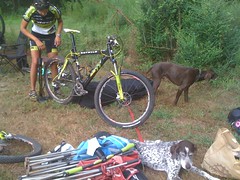
Namrita was racing. Eddie's tapering for the TNGA.
I fake-helped them set up their tent. Their dogs attacked my face with dog kisses. Well, one of them did.
I warmed up with a little spin around the park. The lake had a bunch of duckweed or something growing in it this time. Maybe it had it last time too, but I didn't remember seeing this much before.
A boy scout troop was camped out up the hill from us, cooking and having all kinds of fun.
We all lined up. Me and Bill and Becky Kicklighter were talking and joking and then everybody started going. Aaah! I guess they said go.
About 5 minutes in, I realized I wouldn't just be limiting my losses. I felt really good. Ok, it's on.
Lap 1 I really put it down, almost went down the wrong trail, slid out in a corner, kind of scuffed up my knee and passed a million riders. Tribble Mill has a spider web of trails. There are some really great trails there, but if you don't know your way around, you could be bored all day. I went out there last year with my GPS for like 7 hours and still missed a long, twisty chunk of it. Apparently somebody knows their way around though, they put a really, really good route together today. Man! Lap 1 was pure fun.
Lap 2 I put it down again, passed another million riders and made an effort to relax and flow. I was thinking more hippy thoughts like at Conyers. I've seen deer run through rhododendron and I swear the branches don't even shake. But when a bear runs through the woods, trees that are like ten feet away from it somehow get all smashed. Be the deer, not the bear. I've been thinking lots of that kind of stuff lately. Kinda weird, but it really works. Lap to was also, pure fun.
Lap 3 and 4 were recovery. I sat up a little, not a lot, just enough to make my pace sustainable. I think it was lap 4 where I managed to leave the pit without a water bottle. I was about a mile in when I noticed. My immediate thought: "I've seen at least 5 bottles out on the course, I'll just grab one of those." Seriously. And then: "Well, worst case, there are muscadines every 30 feet out here." I later realized I'd need to eat a LOT of those and it probably wasn't a viable solution, but hey, my head was kind of in the right place. A 6 hour solo singlespeed rider have me a pull off of his Heed on the short little gravel road section and on the first descent there was a full bottle lying in the trail. Score. I drank it. It tasted like tea or something. Then later I realized I could catch any number of illnesses by drinking after somebody I don't know. Probably should have opened the bottle and drank it that way rather than through the top. Or, maybe it fell out before they drank out of it. Well, too late now.
Lap 5 was cramp management, probably from not drinking gatorade on lap 4. Lap 6, I was completely cramp free and starting to pick the pace back up, but was really starting to feel it.
Lap 7, I was tired, but not super tired, still riding strong, just ready to be done. But I got a song stuck in my head. Soundgarden covered Black Sabbath's "Into the Void" on their obscure SOMMS album by playing the music and singing a speech by a Native American chief criticizing the white man's perspective on land. It rocks, profoundly. And somehow it seemed just right at that time. Maybe because of that "be the deer" thing from earlier. Anyway, I didn't just get it stuck in my head. It was way more intense and detailed. Like I was at a concert, listening to it right there, getting excited in anticipation of the drums coming in, and I got that "Dude, I'm hearing them actually play that awesome riff!!!" action. But, of course, I was not at a concert, I was riding my bike. It didn't distract me from riding, but after a while, I was like, man I really need to snap out of this. I've heard of people having auditory hallucinations when they're tired, but I've been waaay more tired than that before, and it wasn't like I thought I couldn't hear it out loud. It was just weird. Eventually I started climbing, the tempo of the ride changed and it went away. No idea. Just went a little crazy there.
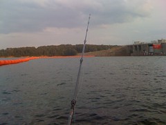
I don't remember when or what lap, but I rode up on a procession of like 40 girls out walking together. At first I thought it was a sorority outing or something, but the girls looked younger than that, maybe high school. They didn't look like runners. I also passed 2 deer about 5 feet off the trail, completely unconcerned with my presence. Lots of folks were fishing at the lake. I waved to them, they waved to me. I talked to one guy, he hadn't caught anything all day. Six or seven riders on horseback were galloping across the dam. There were other things to, but I don't remember. Things I don't usually see in a bike race.
The weather was so nice today too. It was cool and breezy for the first few laps. It did get a little warm later, but nothing like it's been. A few times the sky got dark like it was going to rain but it never did. I hope it stays like this for a while.
Seemed like everybody did pretty well today.
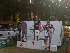
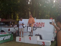
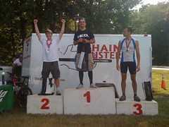
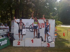
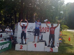
Vonnie - 3rd in 6 hour solo singlespeed.
Bill - 2nd in 6 hour solo clydesdale.
Me - 2nd in 6 hour solo sport.
Namrita - 1st in 6 hour solo women's.
Shane - 2nd in 6 hour solo expert.
Best finish yet this year, and only like the 3rd time ever on the podium in a solo event. Woohoo!
Me, Bill and Vonnie kicked back for about a half hour and I helped Eddie and Nam pack up some of their stuff. I usually bail out quick because I usually end up 10th or lower. But when you hang around, that deeper tired sets in and you don't feel like driving any more. Ugh.
I did grab some good dinner at Parma. Kathryn and the kids were at an art reception when I got home, so I grabbed a shower and relaxed...
This weeks beatdown came courtesy of all kinds of things not specifically related to cycling. I think I'm kind of getting over whatever cold/flu/allergy I've got. I still have congestion in my chest, but it's getting better, even without the meds. My neck is another story. It's getting better, but very slowly, and the meds make me so sleepy, but they make such a difference, I'm staying on them. So, to start with, I'm drugged. I also went to the dentist yesterday for a check-up on an implant I got last year. It's looking good, time for a permanent crown. But the temporary didn't go back on just right and I had unnerving dental pain all night. Dental pain equals zero sleep. This morning they fixed it, and it was the best feeling ever. The ride to work was slow and lame. Cobwebs in my lungs. I felt better on the way to the shop, but I was in no shape to ride hard. I punked out all the way down to the B2 group. It turns out B2 can be really tough if you're drugged, sleepy, counter every attack, bridge to every break and take long pulls. I still felt like a sandbagger. I weighed myself when I got home. 153 pounds. That's the lightest I've been yet this year. I'll probably bump back up to 156 or so by this weekend, fully fed and hydrated, but it means there's hope for me in the race. If you can't be strong, the next best thing is light.
Yesterday I bailed on the Fool's Gold. Friday I was super sick, all day. I can't believe that this is just bad allergies. I slept most of Saturday. Eddie called me today though and said that it was a good one to miss. Horrible rain, bad trail conditions, plenty of crashes, trashed bikes, you name it. He called the race after 50 miles. Few or none of the 100 mile riders objected. I envision some trail work days in my future.
Today I felt a little better, only slept till noon and rolled out to Lawrence Shoals with my Dad. It was a long haul, 2 and a half hours of driving, but with 20 miles of trail, we figured it was worth it.
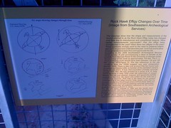
The other name for Lawrence Shoals Park is Rock Hawk Effigy Park. Named after this big rock pile that once looked like a hawk.
They just built a big tower where you can walk up and get a good view of it. Apparently it's changed a lot since the late 1800's. Nobody knows exactly why but there are a lot of theories.
The rain that's been killing Georgia for the past month had taken it's toll out there too. Mainly, it washed pine needles and leaf duff downhill until it clumped up. Every 3 feet there was another clump. Bumpity, bumpity.
The trails were a little confusing. The map only shows the main trails, but there are several marked loops off of them, and they're more singletrackish than the main trails.
The McLean Loop has a plywood berm on it. You can kind of see it at the bottom of the hill here.
I thought maybe I'd see ladders or other structures, but no, just that berm.
McLean also rolls out over a big rock at the water's edge.
We figured out most of the trails on the north side, but I still don't understand the Granite Shack Loop.
The Hawk's Head trail was fairly challenging. Tight, twisty and steep. So twisty that there was a tree down that crossed the trail in two different places a hundred yards away from each other.
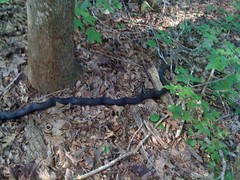
On the Yellow Trail, we ran across a Black Rat Snake.
Or, at least I'm pretty sure that's what it was. White chin, almost triangle shaped head, but not quite, kinked up when startled, didn't run from us, not big and fat...
Near the end of that loop, my dad started feeling really sick at his stomach and kept having to stop to let it settle down. We limped back to the car and he took a break, hoping it would go away...
But, no luck there, and we packed it in. At the first gas station, he grabbed some powerade and was feeling better in 5 minutes. Our theory is that in Dallas, the humidity is really low compared to Georgia and he can ride with just water there, but here he sweats way more and after a couple of hours, he's out of electrolytes. Maybe. Hard to say. We'll see next time.
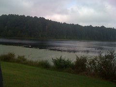
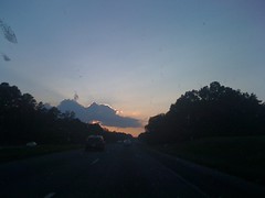
The sky was especially cool on the drive back.
I felt pretty good today, either the rain's washed the allergens out of the air, or maybe I'm getting over the cold. I can still feel it in my lungs, but it's not as bad this evening as it was yesterday evening. The next 6 hour race is coming up in a week. I definitely don't expect to podium this time, but I hope I don't lose too much time.
The Fool's Gold is right around the corner and the course has to be marked. Every year, I help Ed and Nam out with that, and today was the day. I guess technically yesterday, but I started writing this yesterday, so at that time it was today. It's cool to mark the course, you get to recon parts of it, feel out your fitness, and so on.
But first things first, you can't flag a course without flagging material, so I ran by the Home Depot in Dawsonville on the way up...
I'd forgotten what color ribbon we were going to use, so I called Ed about that: "Pink, hot pink, like your undies!" Ha, ha. Joke's on him though, my undies are actually black with little flying pigs all over them. I bought 4 rolls of tape. Ed must have been by there earlier in the week though, because my 4 rolls almost cleaned them out.
I got to the Bull Lot about noon and it was surprisingly not-all-that-hot. This year, the route's going up Bear Hare and down Bull, backwards from previous years. I'd never climbed Bear Hare before, so it would be interesting.
On the Bull Mountain Cutoff, I picked and ate many muscadines.
You can't walk 30 feet in Georgia without finding these, and they are so tasty and delicious.
I passed the ancient School Bus of Booger Holler. It's hard to see coming from the other direction. I'd bet most people have never seen it at all.
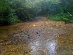
Lance Creek was looking nice.
Right as I finished flagging that turn, it began raining, intensely, for like 20 minutes. Just long enough to soak everything and turn me into a silt magnet.
Speaking of silt, this year we had record drought, followed by record rain, followed by weeks of alternating record heat and thunderstorms. Perhaps the worst possible combination of conditions for exposed dirt. Every road out there has ruts and bad washboards in the corners. The old-school trails have a nice layer of silt going at the bottom of every hill. Even the new-school trails have a thin layer of silt evenly distributed across them by runoff from the backslope. It'll harden up this winter, but right now, it's like riding on wet beach sand and I collected it on every surface of my body, all day.
The climb up Bare Hare was more difficult than I thought it would be. There's a long rideable-if-it's-dry section that I had to walk. I wonder if I'll be able to ride it during the race.
At the top, I remembered Lance Creek Falls. I've been up there a hundred times, and I almost always forget about it, but today I remembered and took a quick little side-trip.
Not so impressive, actually...
More of a trickle than a falls. Maybe that's why I usually forget about it.
Descending Bear Hare the other way was super fun. I've climbed up Lance Creek Road and come down Bull from there, but never descended the top of Bear Hare. The rhodo tunnels feel a lot tighter coming down than going up.
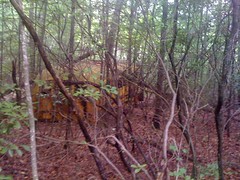
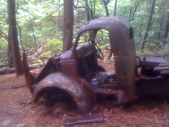
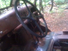
I stopped briefly at The Truck too.
I've seen it a hundred times, riding by, but today I actually thought a little about it. It's an old flatbed, probably an old logging truck. Three sets of tires are missing. The remaining tires are bald. The interior is completely stripped out and lots of parts under the hood, including structural components are missing. I could imagine people taking souvenirs over the years, but it seems unlikely that random people could make off with everything that's missing from that truck. I've seen old wrecks dumped in the woods before, but usually at low elevations and close to a road. This thing is way up in the middle of nowhere. Maybe it was barely running, so they parked it up there, cannibalized it for parts for the rest of the fleet and then just abandoned it. Who knows? Fun to think about though.
Not a minute after leaving the truck, I saw a relatively large black bear. First I heard it, then caught sight of it fleeing off to my left. As I rode by, it paused, looked back then took off again. Like: "Run!!! Hmm, I appear to be running. Why am I running? Oh yeah, that thing! Aaaah! Run!!!"
A little further down I saw a pair of turkeys too.
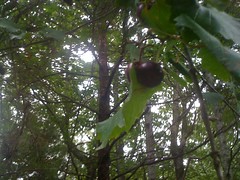
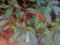
So I marked Bear Hare, Bull and the 83 bypass and then ran into another thing that you can't walk 30 feet in the Bull Mountain area without finding. Some sort of cherries, I guess?
The fruit is pitted, and the edge of the leaf is toothless. Pin, Black and Choke Cherry leaves have teeth. These are more like laurel leaves, so they could be the dreaded, toxic, Laurel Cherry, but I think those are dark purple, and these stay red. I've tasted them before and they taste like cherries, and sweet or tart, red berries are generally safe to eat, but I'm reticent to eat them outright until somebody can tell me what they are.
Right about then, Eddie called me and sent me up to mark Turner Creek. On the way up I was caught by David Hall, who was out recon'ing the course. I recognized his name, he's signed up for the TNGA. Nice guy, we chatted a bit. He took off up Winding Stair and I hung a right onto Turner.
I've always seen a little side-trail off of Turner Creek, so today I dropped my bike and hiked it. It turned out to be clear though, I could have ridden it. It appears to just have been the former route of Turner Creek, as it just breaks off of and rejoins the main trail. It's possible horsemen still use it to avoid encounters with fast-moving bikes. I've heard there's an old homestead up in there somewhere, and hoped the trail would pass by it, but no luck there.
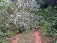
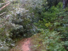
Dave had been on Turner Creek earlier in the day and warned me about a huge, downed tree. He wasn't kidding. It took me almost an hour to create a rideable path, turning this...
...into this.
That's what an hours work looks like.
I actually ran into Ed heading back toward my truck. He gave me water and sent me up the Moss Branch connector and Jones Creek Ridge to mark those trails. I marked them, and checked out a new trail, just recently opened to bikes that leads from 83 down to the lot.
I was now, officially tired, wet, covered in grainy silt, and very ready to be clean. I drove back to Wahsega, walked down to Ward Creek, took off all of my clothes, except for my shoes and bathed in the creek. I was pretty well concealed, and there weren't any cars at Wahsega, but still, after a while that "Woohoo! I feel so liberated" feeling turned into that "Ok, this is awkward" feeling and I got dressed.
I met Ed again and we drove around Montgomery Creek and Winding Stair, marking those roads. I think there's just a little bit of singletrack left to mark behind the camp. Hopefully Ed'll get to that tomorrow.
I'm not sure how I feel though. Allergies have been killing me, the allergy meds don't seem to be doing anything except making me more tired. The muscles on the right side that I use to hold my head up while riding are overworked from ORAMM and bother me pretty constantly. The meds for that also make me tired. With all that going for me, I'm actually thinking about bailing on the race. We'll see though. Maybe some good sleep is all I need.