Wednesday, October 28, 2015

White Oak Mountain

Where the heck is White Oak Mountain?

It's a mountain, in North Georgia. It's hard to describe where it is though, exactly. Northwest of Horse Range, assuming that's not an equally obscure name... South of Pinnacle?... Go like you're going to the Raven Cliffs trail, and instead of parking in the lot, just keep going all the way up the road until it says you're not allowed to go any more. The mountain above and to the right is White Oak Mountain.

Why wander off to such a nondescript location?

I do that.

There's this Chattahoochee WMA Map that I found years ago, from 1980, and it shows the woods looking a bit different than it looks today. I'd already gone out in search of some of the other details, but the one that had my attention this past Sunday was how FS244 is shown leading all the way up to White Oak Gap. It's also shown as gated there, as if it might keep going. I'd been up 244 before, years ago, and it stopped well short of the gap. This past Sunday, I was going all the way.

I parked at the last little campsite, way up at the top of FS244.

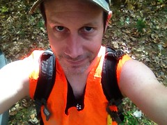
It was about 11 o'clock when I got started, but you never know. Firearms season started October 17th, so I pulled out the orange vest.

Hunter Orange

There was a maze of little roads up there. It seemed likely that continuing straight, in the most well-travelled-looking direction, and in the direction with the signs that specifically say don't-drive-here-but-it's-cool-to-walk-here, would be a good idea, so I tried that first.

There were indications that people go that way, at times. Right away I noticed this little makeshift shelter.

Shelter

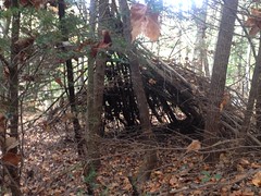
Funny how many of those I've seen in the last year.

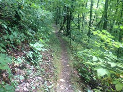
And it looked like despite the signs to the contrary, somebody had driven up that way not terribly long ago. The trail was open, free of overgrowth and deadfall, and easy to follow. It seemed somewhat popular and even looked like it might be making a shape similar to the one on that old map.

But then it hung a left and ran directly up one of the spines of whatever unnamed knob that is between Windy and Walnut Gaps, to the very top of the knob. There was a little campsite there, and evidence of a trail leading north. I realized I wasn't at White Oak Gap, but for all I knew, the road went over the back, hung a right, and wound around to the gap. It didn't make all that much sense, I mean who would think to route the road like that? But I've seen stranger things, so I went with it.

Oh, how terribly wrong I was. The trail just bombed directly down another spine on the other side. A firebreak? Perhaps. It ended abruptly at Pleasant Branch (or Pheasant Branch depending on which map you read) and that was that.

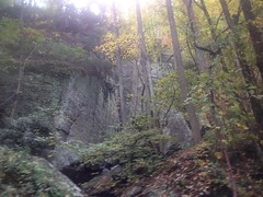
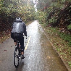
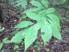
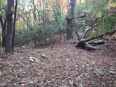
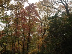
Though the trail was uncomfortably steep and sketchy due to it being fall, with the leaves and all, it was also distractingly beautiful up there, what with it being fall, with the leaves and all.

Fall Underbrush

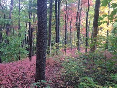
I mean, look at that! And that's even with my iPhone washing the color out.

It was ironic that I'd ended up on Pleasant Branch because that morning, I'd debated whether to go for White Oak Gap or see if there was an old rail leading up Pleasant Branch. I'd opted for the former for some variety, but ended up on Pleasant Branch, just the same. What are the odds?

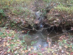
Across the creek there was what looked like an old skid. It looked like it ought to lead to FS240 and it did. I took the road and rummaged around Allison Ridge for a while without finding anything especially interesting.

I needed to get back up top though, and opted for what looked like a second firebreak, leading uphill from Pleasant Gap.

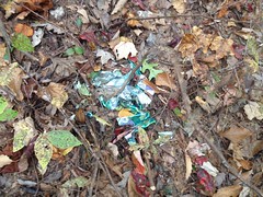
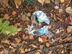
Somewhere in there I found the first mylar balloon of the day.

First Mylar Balloon

The firebreak turned out to be the WMA boundary as well.

WMA Boundary

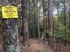
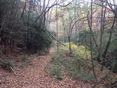
It looked like someone or something goes that way with some regularity too. The firebreak itself was old, unmaintained, sometimes overgrown, and occasionally choked with deadfall, but there was a clear path along or to either side of it, all the way up to the ridge.

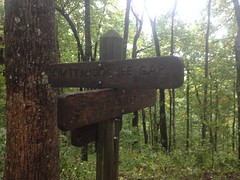
The signs appeared to follow that path too, rather than adhering directly to the firebreak. In a few places, like in that photo above, it looked like somebody had maybe not seen a sign in a while, and hammered up a new one, not realizing that he was just standing behind the tree that the sign was on. There were at least two locations where signs were posted, one directly behind another.

At Slater Gap, the woods was really wide open and relatively free of underbrush. It was easy going for a while, but as I approached Double Head, the brush got super, super dense, and I sidehilled around to the north rather than push over the top.

It looked like I wasn't alone in that either. I kept finding game trails, all along the side there, that would run for a few hundred feet before petering out. Pigs? From the rooting, and the droppings, it appeared so. Huge, huge pigs.

Dropping down to White Oak Gap from Double Head was substantially more difficult than I expected. I emerged from the underbrush into a thicket of surprisingly tall Rhododendron. Not that ground-choking mangrove rhodo, but the kind with trunk-like branches that you can walk under. Fortunately, you can walk under it. Unfortunately, it blocks out all sunlight and nothing grows down there. The hillside was super steep, and super sketchy. I slipped once, kind-of sat down onto one hip to save it, but then kept sliding, and started picking up speed. Fortunately the rhodo was dense enough to grab on to, but that's what I had to do to keep from accelerating downhill. Sketchy, sketchy, sketchy.

There was just that once incident though. Other than that, everything went well, and I found the gap without any trouble.

White Oak Stamp

There was some kind of trash up there. Toilet paper, I think. It looked like a popular place.

It was a 4-way intersection too. There were trails leading in every direction. I knew that the one to the east would get me back to the car, so I figured I'd save that for later. It was the one to the west that held my interest. I had an idea where it would wind up, but there was only one way to find out.

The trail was wide open and the canopy was clear way above my head. One good way to tell who uses a trail is by the height and width of the canopy. Hikers like at least 7 feet of clearance and about three feet of width. Mountain bikers like the a little more height clearance but don't mind a little less width, as long as the brush is low enough for the bars to clear. Riders on horseback like a little more height still, and a little more width too. It felt like a horse trail but I didn't see a single track by man, machine or beast though, all the way down the mountain.

I did find a muffler though.

Muffler

Really old one. If my brother hadn't had a muffler like that on his bike back in the day, I'm not sure I'd have known what it was. So, I guess that's another user. I hadn't actually considered motorcycles, so it was funny that the only evidence I found was from one of them.

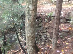
It looked like somebody had once maintained the trail too, as a trail, not a road. There were really well constructed (though also very old and backfilled) water bars all over the place.

Really Old Water Bar

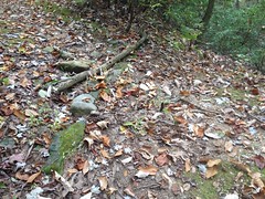
Hard to tell in that photo, but they were constructed of large chunks of rock. It reminded me of the ones up on Wagon Train.

I did eventually find two hoof prints too, and some droppings. One print in sand and another in mud. They looked pretty old though. The droppings looked equally old. Whoever rides up there hasn't in a while, and doesn't appear to very often.

The one trail eventually gave way to a maze of them, all equally well traveled and maintained. I didn't have time to explore them all, but I gave it a shot.

Someone had lost their jacket out there too.

Missing Jacket

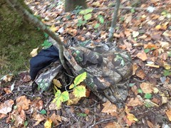
Man, what a drag. I hope they find it.

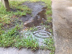
The topography was fairly complex down in there. More than once I realized that I wasn't where I thought I was, but eventually I figured it out, and when I saw this, it confirmed my suspicions.

Extracted Culvert

Back in the early 2000's, before USFS published its GIS data, before you could download a map of the forest, I'd find out where things were by driving around with the kids, then riding what I couldn't drive, and then hiking what I couldn't ride. Half the time, with the kids in tow. On one of those excursions, we ended up down FS57 as far as we could go. To that exact spot, in fact.

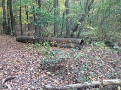
I recognized the extracted culvert.

I recognized the extraction site.

Extraction Site

All right, I was on one of the lines that I already had on my map, right about where I thought I was.

I wandered around a bit down there, checking out the side trails in the immediate vicinity.

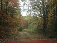
The weather was great. The trails were clean and open. The treetops were all bright and colorful.

Fall Treetops

The only problem I had was hunger. Oh, man, it was definitely lunch time. That culvert from earlier seemed like a good spot to kick back on, so I sat up on it and had a bite to eat.

Lunch

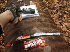
Yeah. That's Skittles and a beef stick, that I'd left in my pack from weeks earlier when I'd brought them along, but never got hungry. Good old sugar and preservatives. Do candy and processed beef even have expiration dates? At the time, I was betting on no.

Hunger sated, I pushed back up over the gap. The trail to the north must lead to FS244. I had a decent idea where even.

Somewhere up there I found the second mylar balloon of the day.

Second Mylar Balloon

The trail was just as clear and the fall colors were just as spectacular on the east side of the ridge. Maple was red, hickory was yellow, and the oaks were still green.

Fall Trail

I found the road, just slightly downhill from my truck. Long ago, I'd drawn a little dotted line on my map. Turns out that dotted line was the route up to the gap.

I'd been keeping an eye on the time all day. I needed to get back to the truck by 4 so I could get home by 6, shower up for 6:30 and get to dinner by 7ish. The 24th was our anniversary, but there was a lot going on that evening, so it worked out better to go out for dinner and a movie on the 25th. To do this, I had to stay on schedule. I'd kept an eye on the time, didn't take any risks, timed everything perfectly, arrived back at the truck just prior to 4:00, got changed, jumped in the car, turned on the ignition, and read 5:04 on the clock.

FIVE o-four.

What the hell?

The hell is... My GPS is so old that it predates the 2005 daylight savings time changes. It had already fallen back. All day long, it had been an hour later than my GPS thought it was. I'd never looked at the time on my iPhone because I only pull it out to take pictures. If I'm on-trail, the GPS is almost always in my hand, set on the compass screen, and I'm constantly marking side trails. It seemed like the logical choice as a timepiece.

Damnit.

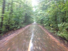
I could barely enjoy the still-gorgeous fall colors on the way down the mountain.

Fall Forest Road

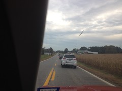
And then, on the way home, I don't think I even went within 10 miles an hour of the speed limit until I hit Highway 400 near Cumming.

Everybody heads home at the same time, on Sunday, it would seem.

Traffic

I'm usually getting out of the woods between 8 and 9, grabbing some dinner and getting home by 11 or 12. There's almost no traffic at that time of night.

Goodness!

It turned out all right though. I was home by 7. The Italian Oven is open 'til 10. We were eating by 8, and the movie didn't start until 9:30. It didn't go exactly as planned, but we ended up having plenty of time.

Ok! So! White Oak Mountain, I have discovered some of your secrets. It's likely that I will fix my mountain bike and ride it all over creation first, but I'm coming back! Eventually... to discover more.

Tuesday, October 27, 2015

Cedartown

This happened two weeks ago, so I hope I remember the details...

Me and Billy had planned on riding with some of his buddies, from Rockmart to the Alabama border and back. Of that I am fairly certain. These were the same guys we'd tried to get together to ride from Smyrna to Rockmart with two weeks prior. Between rain and unexpectedly cold temperatures though, that ride hadn't worked out any way close to the way we'd expected.

This one didn't work out all that much closer.

The night before, one of Billy's buddies reminded him that we were meeting at the Cedartown Depot. Hmmm... "I thought we were starting in Rockmart. Well, maybe Cedartown is only a mile or two past Rockmart." thought Billy and I simultaneously as we read that email. But it runs out Cedartown is about 15 miles past Rockmart, and only about 10 miles from the Alabama border. And, they were planning on riding all the way to Anniston, which is like 40 miles further into Alabama. And, one of the guys had already started 30 minutes before we arrived, figuring we'd catch him. And, the other guy was going to get a head start too, for the same reason, so he was leaving as we arrived. AND, it was an unseasonably cold 36 degrees.

At least it wasn't raining.

We arrived at the Cedartown Depot at either 8:30 or 9, I can't remember now, just in time to see one of the guys off.

Cedartown Depot

It doesn't look all that miserable in the photo, but it was seriously cold and horrible standing around in the shadows.

To ward off the shivers, we got dressed in like 15 layers of gear...

Billy Getting Ready

(Or I did at least. Billy had no base layer and must have been pretty damned cold.)

...and headed west.

Rolling West

It was the first cold ride of the year, and I was not used to the cold, at all.

I was struggling too. I wasn't sure if it was too many miles during the week before or not enough miles during the week before, or whether I was coming down with something, or if it was just the cold, but it hurt. I had a really hard time maintaining any decent level of effort.

Billy didn't seem to be having an easy time either, so I chalked it up to the cold.

After 10 interminable miles we reached the border.

Alabama

Billy's buddy was there, though I guess he was hidden behind the arch when I took that photo.

Fortunately there was a circle of blazing sun right there and we got pretty warm standing around talking. The one guy that had left way earlier was somewhere closer to Anniston. The guy who'd left right as we'd gotten to the start had been there for 5 or ten minutes. It would seem that they had both overestimated our ability to catch them.

We chatted for a bit, then headed our separate ways. My and Billy's plan was to ride back past Cedartown, to Rockmart, grab some lunch and then ride back, thereby having ridden the entire Comet, both ways, in two rides.

At that point, the sun was coming up for real and it was probably in the low 40's. I could ride without my jacket, and whatever terribleness had been working on me earlier seemed to have decided I wasn't worth bothering any more.

The Silver Comet is a rail-trail, but between Rockmart and Cedartown, it diverges for a while because the rail is still in use through there. During this divergence, there are some seriously long and steep hills, unlike anywhere else on the trail. I remembered them from when the girls and I had ridden that section. It was the only time they'd had to drop their front ring. We were still reasonably fresh though, and made decent work of the hills. They seemed like they'd be tougher in the other direction though.

Beyond the hills lay the bustling metropolis of Rockmart.

Rockmart

And just off the square lay The Rock Cafe, promising delicious lunch and cozy accommodations.

The Rock Cafe

We grabbed some pizza, though we didn't go full-on meat-lovers this time, just pepperoni. And it was really, really good. In fact, thinking about it now, I'm actually getting a little hungry.

Sitting there in the restaurant, I honestly wasn't looking all that forward to the ride back. It was only 15 miles or so, and we were well rested, but those hills man... Those hills.

The hills weren't so bad though. It was in the high 40's by then too. The shoe covers were doing their job really well. I actually felt reasonably comfortable most of the way back.

When we got done we messed around with Billy's car for a while. It makes some CV-joint-sounding noise when it's cold and you turn right, but it can do it when you're not moving at all too, and it goes away with it warms up. So weird.

I remember it as a decent ride, but I also remember that at the time it seemed like a slog, so I'm not sure why it seems like it was a decent ride to me now. The mind is weird that way, I guess.

The ribs felt good the whole time, and I felt like I could actually breathe for the first time in a while. My shoulders and back were a little stiff, but nothing like they'd been before. Getting better for real, it seemed. At long last, getting better.

Monday, October 12, 2015

Raven Cliffs

This morning I had two ideas about where I wanted to go. They were both in the same general vicinity, but far enough apart that I really had to commit to one or the other. I actually left the house without deciding exactly which to tackle though, and I figured I'd make the decision on the drive.

Right about then, two unusual things happened.

First... 6 or more police cars passed me going the other way, lights and sirens on. Then, after I turned right and went a block or two, at least 6 more passed me, turned around and followed the first 6. Then, even more passed me and took a right, as if to approach from a different direction. Two things seemed wild about this. First: What the heck happened that "all units" needed to respond to. Second: Are there usually THAT many police cars in my general vicinity? I mean, at least 15 police cars were able to drive past me within 3 or 4 minutes. I've honestly never seen that many in such quick succession.

The second unusual thing that happened was Clark called me. Funny story there... My phone rang with a 229 area code on Friday. I answered, but the line was quiet. Clark and Suzy are the only folks that call me from the 229 these days, so I called them, figuring maybe I didn't have one of their numbers on file and there was a bad connection or something. I didn't get anybody though, and just left a voice mail. Well, Clark was calling me back because he'd just gotten the message. No, it wasn't them, no idea who it was, but they were on their way back up to Sautee and wondered if I was up to a little Adventure up that way.

I was. In fact, both of my prospective Adventures were in that vicinity. What luck!

They'd been in Atlanta Friday and Saturday cooking at the Atlanta Cheese Festival and Eggtoberfest on respective days. They were ahead of me though, and would probably be about finished unpacking up by the time I got there. Woohoo!

Everything worked out. I got to their place in good time. They were just about picked up. We relaxed for a half hour or so, but then decided to go for a hike up the Raven Cliffs Trail, which was one of my prospective Adventure plans.

It had been dry at my place, but had apparently rained up there some time earlier, and the trail was slick. Not exactly muddy, just slippery. Good old clay. Got to love it if you live in Georgia.

We survived the clay though, and made it to the cliffs.

Raven Cliffs

There's a bit of a clearing that seems like a logical place to stop when you get near the cliffs, but since there were a lot of people coming and going, we moved a bit to the side of it. Almost immediately after doing so, a guy started spitting and slapping himself and stamping like mad, off to my left. His unconventional tantrum raised my eyebrows, but my mind didn't immediately match those behaviors to any known pattern. I was unsure how to react. What was the meaning of this interpretive dance? Should I flee? Render aid? ??? ?????? But then I saw a small swarm of yellow jackets emerge from the ground at his feet, and it was clear. They were uncomfortably close, and he seemed to have an above-average fear of them.

I backed away, and we crossed to the other side of the creek on some rocks.

"Yellow jackets don't know how to cross water, right?"

People kept coming and going, stopping right there, and noticing the nest. Some had calm, measured responses. Others danced wildly. Then others stood idly by, oblivious until the swarm engulfed them. We motioned and pointed and shouted "Yellow Jackets", but the water was loud, and they were probably Bulldogs fans anyway. Go Dogs. Beat Tech.

I did walk over and get one lady's attention though, and it was lucky because she was allergic.

Everyone up there had selfie sticks. Like, literally everyone. Well, not literally. I didn't. Clark and Suzy didn't.

Clark and Suzy

I don't know what the kids are up to these days. Back in my day if you wanted to take a picture of yourself you had to do it with your own outstretched arm. Darned kids and their newfangled whatsits.

I guess technically it was adults with the selfie sticks though. Darned adults.

On the way back we took a couple of detours. Long ago I'd seen a side trail that appeared to switch back to the east. Raven Cliffs is an old rail bed too, and recently, with all the old rail beds I've been exploring, and all the switchbacks I've seen on them, I figured that's what this side trail was. I wanted to see if it took the trail up over the falls.

My memory was totally faulty though. We explored several little side trails, all of which turned out to be old skids. None of which were anywhere near where I'd remembered that one to be. In the end, we found the trail I'd been thinking of, but my mind had moved it much closer to the falls than it was, and it wasn't a switchback anyway.

Clark says I'm getting old.

On the way out we stopped at one of the smaller falls for a minute.

Falls on Dodd Creek

The recent rain made it really flow, but that same rain made the trail down to it really sketchy, so that was about the closest we got to it.

From that vantage though, one of the deep stacked-stone fills that once supported the rail bed was clearly visible.

Deep Fill

It's a familiar sight these days, but that's about the deepest one that I know of on any of those trails.

We took the old route out to the highway and then enjoyed diversity-of-trail-experience by taking the road back to the parking lot.

Diversity!

We also found where the old rail approached from the south. It looks like there might have been a pretty big trestle there at some point, spanning Dodd creek and most of what's now become a campground. Some day when it's cold and nobody's camping, I'll have to go back and see if I can figure out exactly where it crossed. It looks like it might have run along the east side of the creek too, rather than along the current route of the forest road. Might have to check that out too.

Someday though, not today.

We headed back to Casa del Neal to feed their dogs, then over to La CabaƱa to feed ourselves. Next time I go there, I'm trying their enchiladas. Their Chile Colorado is good, but I'm developing a hankering for some enchiladas.

It's trying hard to be fall. The leaves will be turning soon and the weather will be just right. Ideal conditions for long hikes and long rides. Barring some disaster, I'll be doing as much of both as I can.

I don't think I'll be waiting long for those enchiladas.

Rockmart

A few weeks ago I went with Kathryn for a short ride on the Silver Comet to test my ribs out, and they seemed to be more-or-less up to a short bike ride. I figured in a week or so they'd be up to something longer.

On that same ride, as we were heading out, we passed Billy riding the other way. He didn't seem to recognize us though, so I called him. Our conversation was something like:

"Yo... Dave-alicious, what's up?"

"What are you doing right now?"

"I'm actually on the bike right now."

"I know! We just passed you!"

"Aw, no way! Well, I'll spin back and see you guys in a second.

And he did, and we rode back together, and he invited me on a ride that he and some buddies of his were going to do out to Rockmart, on the 3rd. That sounded like a great idea. My ribs felt fragile at the time, but I was sure that by the 3rd they'd be feeling pretty solid.

Indeed they were, but on the night of the 2nd, it rained, all night, the forecast showed a 60% chance for the rest of the day, and on the morning of the 3rd everybody cancelled and pushed the ride to the next day. Ironically, it stopped raining at about 8AM, dried up, and never rained again all day.

That night though, it rained again, all night. The next morning it was still sprinkling...

Raining

...but the weather forecast called for somewhere between a 15 and 25% chance of rain for the rest of the day, so Billy and I showed up. The other guys knew better.

The Army gets more done by 9AM than most people do all day, and they were out getting something done that morning.

Army Reservists

They appeared to be reservists, doing a training run or something. There were dozens of them, and the last few were finishing up when I got there. Some of them were off at the other end of the lot doing push up and sit ups. Others were driving home. Done before 9AM. Just like that old commercial said.

Billy met me right at 9 and we got going quickly.

Conditions were miserable, by any reasonable standard.

Rainy Comet

We were dressed appropriately though - arm and knee warmers and a rain shell. I was soaked to the bone, but at least I wasn't cold. The most uncomfortable things were actually my eyes. The goggles do nothing and I had to ride without them. The wind does something though, to my eyes. I don't think I'd ever ridden that far, on the road, without glasses. It gets uncomfortable after a while.

We passed way more people than I expected to for the conditions. Mostly joggers, but several serious-looking riders too.

The Brushy Mountain Tunnel looked inviting.

Rainy Brushy Mountain Tunnel

I fantasized about stopping inside, curling up in one of those little notches built into the walls, and getting a little fire going.

Aside from that, I don't remember all that much about the ride out. Billy almost ate it twice because he couldn't tell where the edge of the trail was, but he saved it both times. Other than that though, it was pretty uneventful.

Pulling into Rockmart, I expected to see a bike-themed sculpture that Ed Baltes made, years ago. I'd seen photos of it being installed somewhere along the trail, way back. It was either long gone though, or just further down. Either way, it made me a little sad because I was hoping to get a good look at it.

The rain let up slightly as we rolled into the square, but it never stopped entirely.

Rainy Rockmart

The last time I'd done that ride, I ate lunch at Frankie's. Frankie's appeared to be closed though.

Frankies Is Closed

Billy knew Rockmart pretty well from having worked there for a few years, and told me a bit about the history of the place as we investigated other lunch options. Goodyear apparently built a tire plant there at some point. The plant was gone, but the houses that the workers lived in were still there, and that part of town was still called The Goodyear Village. We rolled through the Goodyear Village to Pizza Depot, which was also closed. Not permanently, but sufficiently as to prohibit us having lunch there.

The Rock Cafe (and Ice Cream Shop) was open though, and its bike-themed accoutrement made me suspect that we might be welcome, despite the likelyhood of our tracking water all over, inside.

We were. And, sadly, we did.

But we also had some delicious pizza.

The Rock Cafe

Mmmm, hmmmm. Delicious pizza.

I got cold sitting there though. It's always a toss-up: take off the wet layers, dry off, and warm up, or keep the wet layers on because those fabrics do provide a good bit of insulation, you're not going to dry off, and you'll just get colder if you take them off? Which route to go depends on so many subtle factors, and I usually have to try both to figure out which is correct. Turned out, taking them off was the right way to go, but I never really got satisfyingly warm. I have yet to discover the secret to "stopping for lunch" in cold conditions without getting so much more uncomfortably cold as to make the experience overall dissatisfying. It's different if there's a fire to warm up by, or a heater going full-on, or something. But we had neither of those. It was just in the low 70's inside, slightly warmer than outside. Something like that always seems to be the case when I want to stop somewhere too. There's always some bit of shelter, but it's never the glorious ski-lodge conditions that I want it to be.

That said... Hurricane Joaquin was on the TV, devastating Colombia, South Carolina with floods. Watching the coverage made me feel guilty about being uncomfortable in the comparatively mild conditions we'd had all morning. I mean, it was bad. Bridges were getting knocked out. Homes were getting damaged and destroyed. The people there really had it rough. We'd had it easy with our delicious warm lunch and "should I take my damp clothes off" dilemma.

Perspective!

The ride back was about like the ride out. Kind-of long. Uneventful. More people out than I expected. Rainy. Not all that bad though, overall.

Rainy Return Journey

My knees were getting pretty tired. That "why are you making me do this after letting me sit around idle for weeks" pain was setting in. I don't think we made as good time on the way back as we had on the way out.

We enjoyed it though. Aside from my tail light getting water logged, shorting out (which turned it on), becoming impossible to turn off, and wearing out the battery, all went well. I did have to wash my bike the next day. And now that I think about it, my clothes had collected so much dirt and grit that the mattress cover we ended up washing with them had to be dried, shaken out, and washed again. So, there was that too.

My ribs were good. As I'd noticed hiking with the girls the week before though, the muscles in my back were super stiff and tired. Way more than usual after a ride like that.

It seemed I wasn't all better yet, but definitely getting there.

Jack's Knob Trail

About three weeks ago, the ribs were starting to feel a lot better, and I was feeling up to walking it off to a slightly greater extent than I had the previous week. To that end, the girls and I headed up to Jack's Gap for a little out-and-back.

What we didn't realize though, until we turned left onto the Richard B. Russel, was that the 27th of August was 6-Gap Century day.

6-Gap Hogpen

Woohoo!

We saw hundreds of riders crawling their way up to Hogpen Gap, the most difficult climb of the entire ride. They were working hard and some were just outright suffering. I wished that I could be suffering with them, but I'd only just been brave enough to go for an 8 mile ride on the Silver Comet a few days earlier. At the time, being able to ride 6-Gap seemed like an impossible dream.

We passed riders carefully, and when we got to the gap, we pulled over and cheered them on for 20 or 30 minutes before heading down the other side.

At Jack's Gap there were port-a-potties and water-cooler bottles and pop-up tents lying about. Those same riders had come over that gap a few hours before. I guess the staff had already started picking things up. We took advantage of the port-a-potties though. Thanks 6-Gap staff.

I had 3 objectives for the day: 1) spend some quality outdoor time with the kids. 2) see how my ribs were doing. 3) see where the railbed that runs along the ridge at Chattahoochee Gap goes.

The "quality outdoor time with the kids" objective was pretty easy to meet. Sophie seemed rather overjoyed to be in the woods. She actually annoyed Isabel whilst proclaiming said joy. Iz wasn't so excited. She's got some Adversity-management skills to work on, and as managing Adversity is part and parcel to being outdoors, I think it just felt like work to her. Nevertheless, after the initial climb, she seemed to have an easy time of it, and it helped that we really got to carrying on too.

The one thing though... Neither of them wanted to go first. It didn't appear that anyone else had gone that way yet that day, and there were little strands of spider webs every 10 feet. Ha! Ok. I'll go first.

The trail was beautiful.

Jacks Knob Trail

I'd hiked the other side, up to the Brasstown Bald Lot before, but never this side. It looked like old-school purpose-built singletrack. No sign of old road or rail at any point. Just trail.

Iz suggested that we should have a code word that we should say whenever we hit a spider web. I suggested that the code word should be "code word". And then in the next 10 seconds, I said "code word" so frequently that I had to interrupt myself half the time. Seriously, there were a lot of spider webs.

There was also a lot of American Chestnut.

American Chestnut

It was quite prolific up there. There was even a little sapling that had managed to grow up to about 10 feet tall. Not terribly impressive as trees in general go, but for a chestnut, it was pretty impressive.

We made it to Chattahoochee Gap fairly quickly...

Chattahoochee Gap Sign

...and paused for lunch.

Chattahoochee Gap

I'd been to that particular gap before, fairly recently, actually. I'd basically followed the Chattahoochee from the campground below up to its source, just below the gap. The trail there is an old railbed, and on that previous trip, I'd followed it south. Today we followed it east. It wasn't immediately obvious, but the old rail continued to the east. It was substantially more deteriorated in that direction though. The backslope had slumped into the cut. Lots more rock was exposed. There was no obvious reason though. It was surprising.

We followed it until the AT diverged from the rail, in the vicinity of Red Clay Gap, then stuck to the AT for a while to see if it rejoined. It didn't appear to. We could see it dropping away below us, and before long it just disappeared altogether. It wasn't clear if it just ended somewhere around there or switched back down the mountain, but it was far too overgrown to investigate. Or, I guess, far too overgrown to subject the kids to an investigation of.

The AT there was kind of fun though. Up and down, with lots of rocks sticking out all over the place. Both girls commented that it was a good bit more fun than what we'd been on before. Unfortunately, we eventually had to turn around and head back through all that less-fun, which they weren't so happy about.

Fortunately on the way back, all of the spider webs had been cleared out. Well, most of them at least. Enough that Sophie wanted to go first. Not enough to make Iz willing to.

We drove back over Neel's Gap and passed by Trahlyta's Grave. We'd been talking earlier about the bear we'd all seen on a Smith Creek hike years back. It was apparently the only bear that they'd ever seen. It seemed crazy to me that they'd only ever seen one, given all the bear that I'd seen. Well, as we approached Trahlyta's Grave, a very large black bear ran across the road ahead of us. There was a truck ahead of us too and the driver had to stop hard to keep from hitting it. I was immediately like: "Bear! Bear! Look girls, ahead of us. Bear!" Iz was dozing off though, and missed it entirely. Sophie was awake, but couldn't see around my seat well enough to see anything. Come on! A bear ran right by in front of us and neither of them got to see it. What luck.

We ate at Moe's in Dahlonega. Whatever that spicy chicken is that they have now... It's pretty good.

I think both girls fell asleep on the way home. My ribs felt ok. A little sore, but not like I'd done any new damage. All the muscles in my back were stiff and tired though, which was a little unexpected. I'd had a little of that on the road ride, but not to the same extent.

One step a time though, I guess. One step at a time.