Tuesday, July 14, 2015

Helton Creek Falls

This past Sunday the girls and I drove all over North Georgia. Iz has been wearing herself out learning new skills at gym and Sophie's been wearing herself out getting ready for a production of The Jungle Book. It seemed like wearing them out even more wasn't a great idea, so we just drove around. It's been forever since I did that. For the past few months, I've always had a destination in mind. It was nice to see how things have changed, and how they haven't.

We did stop here and there. One of our stops was Helton Creek Falls.

Helton Creek Falls - Lower Cascade

On the way down to the falls, a guy told us there was a large Water Moccasin hanging out on a chunk of a tree that had been cut out. I asked him if he was sure it wasn't a Midland Brown Water Snake, as we're a bit far north for Water Moccasins. He wasn't sure, but either way, he wasn't going to bother it! Seemed like a good idea.

We were all looking for it on the way down. I almost walked right by, but Iz spotted it, right where the guy described.

Midland Brown Water Snake

Yep, Midland Brown. Iz took some pictures. She also named it Steve. It was still there when we left, 20 minutes later, just lying there in the sun.

Thanks for hanging out Steve. Good to see you.

Monday, July 13, 2015

Cohutta WMA

My brother had a birthday recently. In mountain biking circles, one is generally treated to a celebratory birthday ride, but between rain and travel and other real-life-related activities, it wasn't until the day before yesterday that the opportunity actually came up for such a ride.

It did though, finally, come up, and it was quite a ride.

John picked me up near my house at 6:45 in the morning. We were supposed to meet Marc and Mark at Bear Creek, and we had to be riding by 8:45. It was possible that "a few people might be joining us" too. The early start was, again, due to life-related activities. John had to be back in Douglasville no later than 4:30 PM.

No later.

It was John's lucky day though. Milling around behind his truck, he just glanced down at a 4-leafed clover.

Lucky, Lucky

Wasn't even looking for it, just happened to see it there.

The day was starting off right. Perhaps his luck would hold.

John Vandal had arrived a minute or so before us. He was apparently one of the people who might be joining us. There were two unrelated crews of Floridians parked ahead of us too. They were not joining us, but I did speak to them for a while. I've done my share of riding in Florida. They'd been coming up here for 10 years or more. We had plenty to talk about.

Mark and Marc showed up on time.

Mark, Marc, Josh and John

Everybody geared up, and fueled up, and we proceeded north.

Bear Creek Road

It felt cool and early. It was a little humid and a little foggy, but that just added to the charm.

It'd been like 2 years since I'd been to Bear Creek, but the woods felt familiar, and the company felt familiar. "Yeah, this is how it ought to be" came to mind.

We climbed the road and started up the trail.

Bear Creek Trail

It started getting warm on Pinhoti 1. We ran into one group of Floridians. One of their guys was lagging back though, so they couldn't ride with us for long.

Josh was asking about bears. He's apparently never seen one. He's been riding up there for 15 years and never seen one. I've probably seen 50 or more. I might need to take him on some of my little adventures. They tend to include bears.

I dropped a water bottle on P1. I have one metal holder and one plastic holder. The plastic holder is garbage off road. Garbage! I've dropped bottles out of it 4 or 5 times now, but I keep forgetting to replace it.

Aside from delays related to dropping bottles though, I didn't have trouble keeping up with the frere, which is definitely an improvement. Last time we rode together, he'd just roll away from me on the downhills, every time.

Pinhoti 1 was fun but Pinhoti 2 was the real deal.

Climbing P2

Marc and Josh were chatting away on the climb, which was a little frustrating. My heart rate was such that I could not have been so chatty. No amount of not-climbing in the mountains can prepare you for climbing in the mountains, it seems. I need to get in some more climbing-in-the-mountains.

I followed John on the downhill, and it more than made up for the slight climbing struggle. Following a fast rider down a twisty downhill always reminds me of watching footage of an aerial dogfight. It's like two fighter jets, one running, one trying to stay lined up for a shot, minus the strategic significance of the conflict, and fear of death, of course.

Mark flatted towards the end of P2 and we could hear the air leaking out of his tire as he pulled into the road. Oddly, he hadn't noticed it until someone pointed it out. I guess it had started leaking slowly, and just become part of the background noise.

Anyway, he had to fix it, so we stopped for a few minutes.

Mark Flatted

There was a big crew of people I didn't know gathered at the bottom of P2, about to head over toward Mulberry Gap. We talked to them for a minute, but they got going pretty quickly. They had places to go and adventure ahead.

We did too, actually. We picked up Bromley, Mike and Chris at Mulberry Gap.

John ran up, refilled a bunch of our bottles and came back looking crazy with ten pounds of water stuffed down his jersey.

The plan for the rest of the day was FS18 -> Windy Gap -> Milma -> Tibbs -> FS28 -> Bear Creek.

Apparently, Mark had described the route on the internet, but the new members of our group misunderstand the direction. I didn't read his description. It might have been confusing, or it might just have been assumed that no reasonable person would climb Windy Gap and Tibbs. Whatever the cause, the result was something like "oh man, we're CLIMBING Tibbs?" All around.

But, it wouldn't be tough for a while. The first 5 or 6 miles to the bottom of Windy Gap was mostly downhill, and we had a good time of it.

Riding Toward Windy Gap

We passed the old firetruck and the Little Chapel in the Woods, and ran along Holly Creek for a long time.

Holly Creek

Tons of cars were parked at Emery Creek. People were playing in the water. A guy was fly fishing from the bridge.

Yeah! Outdoors!

Fort Mountain loomed off to the left as we approached the climb.

Fort Mountain

The forest road leading up to the Windy Gap lot was mellow and fun. Something large had died up there in one of the curves, but other than that, the climb was pretty nice. I'd been keeping on top of fuel and water so far. I wasn't hungry, or tired, or weak, or thinking strange thoughts, or suffering non-existent pain, or anything else. I felt good. It seemed like everybody did.

Climbing the Windy Gap trail was really tough though.

John Climbing Windy Gap

Fortunately, it was smooth and tacky. It's so often dusty and rocky and loose. I was pleasantly surprised. It is long though, and the pitch is relentless. There are 3 kicks right before Milma, and John was all: "When I see those 3 kicks, we're almost done."

One, two, three.

Everybody was sitting down waiting for us at the turn.

Everybody Waiting For Me

I checked my bike. I'd noticed a bent link in my chain right before we started. It had been giving me a little trouble all day, and was the apparent culprit in some issues I'd had during the past few rides, but it was manageable. I'd wondered if it would give way during the horrific climbing, but no, it still looked the same. No need to address it just yet, at least.

When Bromley arrived she wasn't sure how she felt about climbing two more miles of rougher trail than that, especially with the temperature climbing as well. Josh had initially planned on turning around at that point too. He was feeling good though. Brom was too, but she wasn't sure how well she'd feel later. John kept looking at the time. He had a deadline and eventually just had to get moving.

Everybody pushed on.

Milma is actually fairly gentle and fun. It's only steep in a few spots, and they're short. It is unfortunately, only accessible via one of two murderous climbs, or one of two incredibly technical downhills, but Milma itself, is great.

John and I both tanked up at Milma Creek. I'd consumed one bottle since Mulberry Gap and it's easy go to through another one on Tibbs. Better safe than sorry.

Though gentle, Milma was also short lived. The great hell lay directly ahead of us.

Tibbs

Josh was all: "I've always heard how hard this is. I guess I've got to find out someday." Or something like that. He seemed to have decided to keep going rather than turn back.

John and Chris took the lead.

Climbing Tibbs

I followed, but Mark and Marc passed me almost immediately.

I think Josh walked most of it, but I'm not sure I rode materially faster than he was walking. He was never more than about 50 yards back.

The bottom 1/3rd was actually in reasonably good shape. I've had a harder time with it in the past than I had that day. But, after the bottom third, it was as tough as it's ever been.

Somewhere in there we ran across a rattlesnake. It was all stretched out across the trail when I rode up, and even though I was probably 20 yards away, that was apparently too close, and it started rattling at me furiously. I've never actually heard one rattle before. I've seen plenty stretched out across the road. I nearly stepped on a timber rattler at Bull Mountain, and a pygmy rattler on Conner Mountain. I walked within a few feet of a pink rattler in the canyon. They were all dead quiet. This one was pissed though. It rattled all crazy and coiled up into a big snake pile.

Rattlesnake on Tibbs

The photo is unfortunately garbage. I had to use maximum zoom to take it and the lens was all sweaty and disgusting.

When Josh walked up behind me, he could neither hear nor see the snake. It had been rattling since it was out of earshot, and to him just sounded like running water off in the distance. It was so well camouflaged that he couldn't even see it without looking for a few seconds, after I pointed out where it was.

Fortunately the trail is really an old road, and really wide right there, and we were able to walk waaaay around it.

Then, not 100 yards later I passed within inches of another snake.

"Black rat snake." [points to it] "Not poisonous. Try not to run it over though."

I swear I've seen more black rat snakes than any other snake. Like 4 to 1 at least.

We climbed and climbed. Eventually the trail degraded into shelves of exposed granite and shale.

Tibbs Ridiculousness

The photo does no justice to its ridiculousness. There's just no riding that.

We walked, and walked, and walked. Josh passed me in some short, rideable section. My legs started cramping. Not that full on, locked-up, going-to-hurt-all-week cramping, but cramping nonetheless. Again. No amount of not-climbing in the mountains can prepare you for climbing in the mountains. I need to do a lot more climbing in the mountains.

As all things do, Tibbs came to an end. As I approached the trail head I could imagine John sitting there, ready to go, counting the minutes until I arrived, but he was actually fairly casual about it. "Hey D, take a few minutes, but I need to get going pretty soon."

No problem. It's not good to sit around for too long after a tough climb anyway.

Mark: "How are you feeling?"

Me: "Heh. I feel like I just climbed Tibbs."

John switched gloves. He'd carried a second set in a ziplock bag all day. Yeah! Nothing like a fresh set of gloves. Apparently Mark had come up with that trick a long time ago. I guess it's starting to catch on.

Chris had already left. Bromley and Mike were still climbing and might still be for a while. The clock was ticking. Me, Mark, Marc, John and Josh headed toward Bear Creek. Josh was out of water though, so he, Marc and Mark took a detour to the Lake Conasauga campground. John kept moving.

"That's my ride guys, I've got to keep moving too."

There are two pretty long, pretty steady climbs on the way back to Bear Creek. They're not bad at all if you're fresh. I could not be described as fresh but they weren't as tough as I'd expected them to be.

The original plan was to take the Bear Creek back, but being pressed for time, we took the road instead. It was just as well though. There are dozens of sweeping turns on the road, and it gave me a chance to evaluate/work-on my tear-ass-around-sweeping-gravel-road-turns skills. I felt a lot more comfortable than I had on Winding Stair when John and I'd ridden there a month or two ago. I was even able to ride comfortably at terminal velocity down the ridge just above the upper Bear Creek lot.

Woohoo!

I'd hoped to get a good view of the whole world from the overlook, but the sumac is really taking over up there these days. I had to reach way up above my head just to get a photo.

Bear Creek Overlook

It's funny... In years past I could have named each of those ridges offhand. Today I don't recognize any of them.

Terrible.

One step at a time.

We got back to the car with about 10 minutes to spare, so it looked like forest road detour had probably been a good idea. I was sleepy on the way back, but some Zaxby's and a coke solved that. Seems like I always eat Zaxby's when I've been riding with my brother. It's becoming a tradition.

I took a nap when I got home, but I wasn't super tired yesterday. A ride like that usually wipes me out the next day, but not this time. I'd made an effort to stay on top of food and water, and I'm sure that helped. Also, I suspect that my legs were kind of a limiting factor, keeping the rest of me from getting too worn out. Whatever it was, it made for a good time that I didn't suffer from later, and that's always good.

Thanks for the ride guys! Great hanging out with everyone. Let's do it again.

Allatoona Creek

There's not usually much to be said about the standard, weekly, Allatoona Creek shred, or at least nothing that I haven't said before. But, notably, this past Thursday, it was a little warm.

Pyramid Building Weather

"Pyramid building weather!"

Monday, July 6, 2015

Upper Chattahoochee River (Sort-of)

It occurred to me yesterday, looking back at these recent journal entries, that one might conclude that all I do these days is hike the Upper Chattahoochee. I have done a fair amount of that, but it is, by no means, all I do. It's just all that I've done lately that's really worth mentioning. I'm on the road bike for a couple of hours 2 or 3 times during the week. That, or ripping singletrack at Allatoona. But those rides are generally uneventful. I guess I need to do some more eventful cycling. Come to think of it, I have been missing that lately. Hmm...

Of course, that said, this past Sunday I WAS back exploring the Upper Chattahoochee again. I've become somewhat interested in the "lost" history of the area. The Byrd-Matthews company built a rail network all through there way back, there were settlements back in there, and there's the Unicoi Turnpike too. None of these things are on any modern map. There are clues here and there though, and if you follow them, they lead to interesting discoveries. I dig that kind of thing.

Combine that with just generally enjoying being in the woods, generally enjoying exploring, wanting to recover my hiking legs, and the fact that Clark and Suzy live up there and might be able to join me from time-to-time... Exploring the Upper Chattahoochee reliably strikes me as a good thing to do.

As such, I did more of it again, yesterday.

Last weekend, I found that there's a clean trail leading north up into the Wilderness above the Upper Chattahoochee Campground, along the river itself. It was getting late though, so I didn't get to follow it too far.

Yesterday I tried to see where it went.

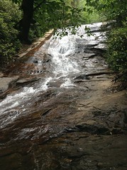
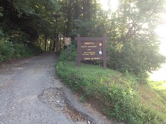
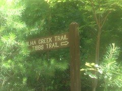
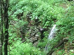
I parked outside the gates of the campground and headed up through it. Pretty quickly I ran into a guy and we talked about the various falls back there. He wanted to let me know about the second one, in case I didn't.

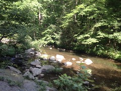
I did. The second one:

Upper Chattahoochee Falls

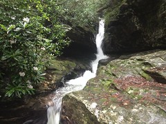
I described it to him like: "water comes tearing down through a crack in the rock" and he knew right away that I'd seen it. Knowledge of that falls is apparently not terribly mainstream, and he almost congratulated me on having it. Super friendly guy too. I love running into people like that.

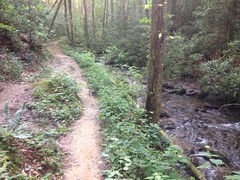
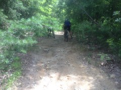
So, I followed the river up north of the campground. Last week I'd followed a trail on the west side, but there was a trail on the east side too. Turns out it joins the other trail at the falls.

Last week, I'd decided that the old railbed ended at the campground, but it appeared that I was wrong about that. The rail also followed the east side of the creek, and apparently, once climbed directly up over the falls. Goodness. The engineering involved... I want to see a photo of that trestle.

The old railbed kept going too. Last week I hadn't even tried to look for it, but yesterday I did, and it was easy to follow. The trail zig-zagged across it sometimes. Sometimes paralleled it. Sometimes led right down it.

There's a field up there too. Crain Field, I think. It's the last maintained human construction below the Wilderness. Yesterday there were several wild boar in the field. As I emerged from the woods, one of them saw me, grunted, spun around, and took off. When it did, at least 4 more followed. I didn't know what it was at first. My mind was like: "that's close! not a deer... bear? boar!" At "bear" I instinctively raised my arms above my head.

I got in a bit of an argument with a doctor about 2 years ago about what I'd do if a bear suddenly walked through the door. Seriously, this actually came up. He contended that my instinct would be to run and thus the bear would kill me. I contended that I would likely stand and raise my arms up because I know to do it, and that's what I'd done in the past when I'd gotten up close to a bear. But, it did make me wonder... In the past, I'd had time to think for a second and choose how to respond. What would I do if I didn't have that second? It appears that I would, in fact, raise my arms. I've apparently trained myself to do that. All right! There you go.

The boar were hidden by the tall flowers but they were grunting and squealing off to the left of me as I circumnavigated the field. I spoke to them nervously. "Yeah, I hear you over there. Keep at it. Whatever you're up to. No need to come over here." Eventually, I put them behind me.

The trail/old-railbed led way up past where I'd been before. When I reached what I thought was the first confluence in the river, I followed the left branch. Turned out though, that I was actually at the second confluence, and needed to have followed the middle branch.

Heh.

It looked like I wasn't the only one that had been confused. There were several wrong-way-trails in the area that eventually petered out. Apparently everybody else figured out where to go though. I doggedly stuck to the left branch though, ignoring indications of trails to the right, figured the trail and old railbed must just end there, and ended up, oblivious to my error, bushwhacking along some unnamed branch all the way up to the AT.

It didn't help that the area was shot full of game trails. I'd end up on one for a few hundred yards, thinking "oh, THIS is the trail" but then it would just disappear. It also didn't help that way down along a creek there are no peaks visible, all you have to nav by is other, intersecting creeks. But, most of all, it didn't help that I didn't once consider consulting the compass (or GPS!) to make sure I was even generally heading in the right direction.

The woods was more-or-less open though, and relatively easy to get through. It had rained earlier, and sprinkled off and on while I was walking. Everything was wet, but if you don't mind the walking shower, it's great. Turns out that wet leaves and branches slip right past you without scratching. Ha!

I found several interesting things up there too.

First, it looked like somebody else might have done what I did.

Cairn

Or, hopefully they did it on purpose.

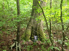
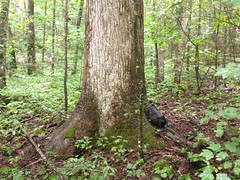
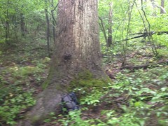
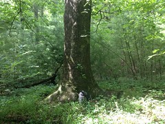
There were also several large trees. Not champions, but certainly bigger than everything around them.

I think this is a red oak.

Big Red Oak

There were two decent sized poplars too.

Decent Sized Poplar Another Decent Sized Poplar

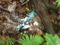
And, of course, the requisite mylar balloon.

Mylar Balloon

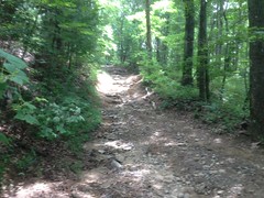
It's not terribly steep up there either. I had a very easy time with the grade. It wasn't that "walk 20 feet, rest, walk 20 more, rest" thing that I've had to do in the past.

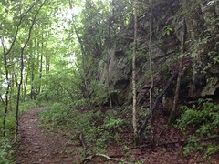
I hit the AT at what looked like a fortified wall. I took a picture of it, but it turned out super blurry. It looked a lot like this though:

Railbed Fill

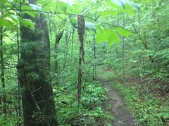
The AT itself was kind of wide, flat, rocky, and really shallow in both directions. Parts of it had been blasted out of the surrounding rock.

AT South of Horsetrough Mtn

The stream crossings were all heavily fortified. Clearly an old railbed. I'd wondered about that. Now I'm sure of it.

I'd figured that I was at Red Clay Gap. From there, I planned on heading west until I hit the Jacks Knob Trail, which would confirm my location. Almost immediately though, I realized that I wasn't where I thought I was. There was a weird corner in the trail that I didn't expect to see.

Dangit, I hate that.

The compass doesn't lie though. Well, actually my compass does, it's poles are flipped, but it lies in a predictable manner. There were only 2 places I could be, and they weren't anywhere near where I'd thought I was. It was at that point that I figured out what I'd been doing wrong for the past few hours. Classic. [mocks self with dejected head-tilt]

Well, at least I knew where I was. I'd cut a few miles off of the route, but hey, that just meant I'd have more free time later.

Onward!

I jogged southish, around the spines of Horsetrough Mountain.

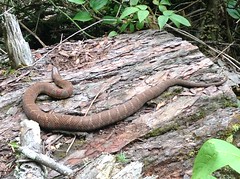
A snake had apparently molted recently and somebody had hung the skin on a tree, for my viewing pleasure.

Snake Skin

A few hundred yard later my stomach growled and I was suddenly hungry.

At the next curve there was a campsite...

AT Campsite

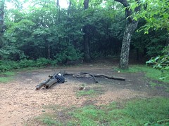
...so I paused a bit to remedy the situation.

Lunch:

Lunch

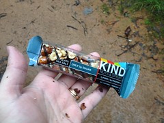
Actually, I also ate about half of a Tabasco Slim Jim.

While I was eating, a guy walked up and we chatted for a few minutes. He'd come from Neel's Gap and he was getting picked up at Unicoi. He was planning on hiking the Georgia AT in a series of day hikes, presumably to test out his gear and fitness, then do the rest of the AT in sections over the next few years. Sounded like a good plan. I might have to do the same some day. He wanted to keep moving though, and didn't stop for long.

I got moving again pretty quickly too.

At the next big curve, there was another campsite, and rummaging around behind it I found some old ruin.

Ruins

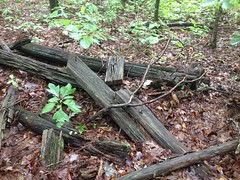
At the time, my mental origami skills weren't up to the task of figuring out what it was. "Some ruin" was all I could come up with. I'm not sure what it even could be. The rail came through sometime between the 1890's and 1920's. The mountain was clear cut, abandoned, and almost immediately bought by the Forest Service. Maybe somebody had settled up there prior to the rail. If so, I'd expect some kind of road nearby. I didn't see one, but maybe I missed it. Maybe it was somehow associated with the rail. Maybe it was somehow associated with the old fire tower up on the top of the mountain.

There were also very new-looking markers up there too.

BearingTree USFS Survey Marker

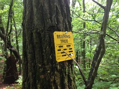
Maybe the area was recently determined to be archeologically significant. Who knows? Somebody knows, not me though.

I ran on to Poplar Stomp Gap, picked up the old Poplar Stomp Road (AKA Poplar Stump Road, AKA Old FS44C) and ran it back down into the valley.

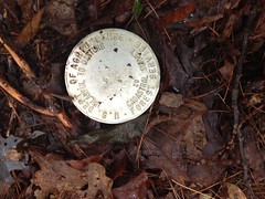
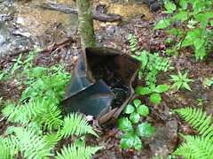
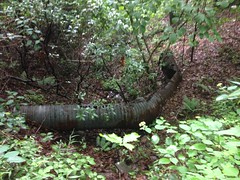
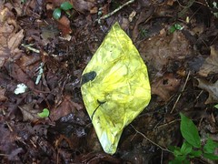
There were a few interesting things there too.

For instance, this weird banged up old metal bucket of some kind:

Banged Up Metal Bucket

And this culvert that the forest seemed to have pushed out like a splinter at some point.

Rejected Culvert

And, of course, another mylar balloon. This time, of the smiley-faced variety.

Smiley Mylar Balloon

I suspect that 44C was also a railbed. It has a very consistent grade. Way up at the top it's narrow and had a heavily fortified stream crossing. But if you do the math on it, it's like 9.3% grade, which is super steep. Even a geared locomotive would have had a hard time with that. It'd have been climbed unloaded though. Maybe that was possible. Or, maybe it was only used as a downhill run and they climbed up somewhere else. This is what I'm talking about... I dig this stuff. Mysteries and clues. Somehow all of that is fun to me.

I hit a couple of side trails on my way down from the ridge.

One of them lead over to what appears to have been the location of the old Vandiver homestead.

No trace of the structure remained, so it may sounds like quite a presumption that there was one, but...

According to USGS topo maps, the creek in the area is named Vandiver Creek. According to a WMA map from 1980, the wildlife planting on either side of the creek, is called Vandiver Field. According to USGS maps, there's a small clearing upill from the field. Uphill from that is another field. Old roads lead between all of these fields and clearings.

The small clearing is now invisible in satellite photos, but it's still there, more or less, with a pretty large white oak dominating the area.

Vandiver Homestead?

The land there also appears to have been levelled.

According to a really old Georgia Supreme Court Case, Vandiver had a farm back in there somewhere (on "Lot 2") and sold timber rights to the Byrd-Matthews company. Twenty years later they built a "tramway" over to his property to get the timber out. At that point he tried hard enough to bail on the deal that it went all the way to the State Supreme Court, who sided with the lumber company.

The Byrd-Matthews rail led up the Chattahoochee, at least to the campground. FS44 from the campground to Vandiver Creek is shallow and consistent and could easily have been the route of the aforementioned tramway.

So, all together, it would seem that we have the Vandiver farm consisting of two fields with a farm house between them. Of course, I could be completely wrong, but this conclusion fits the evidence.

I checked out a few little trails that led down on Vandiver Creek too.

Down there some snails were mauling this mushroom to death.

Mushroom Lunch

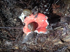
Can you imagine a piece of food so enormous that you can crawl all over it? That's what it must be like for a snail.

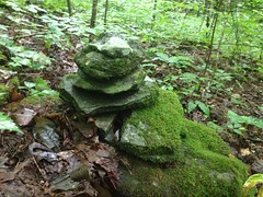
Someone had recently built a little monument down there too.

Vandiver Creek Monument

I'm pretty sure that wasn't there last week.

I also managed to get a good look at Vandiver Falls itself.

Vandiver Falls

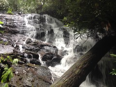
In case you're interested in doing the same. It's not worth it.

Every now and then I look back and say "Ok, THAT was the sketchiest thing I've ever done." The scramble down to the falls is, to date, the sketchiest thing I've ever done. When it's steep or loose I'd always tell my kids "hands and feet", but this was hands and feet and knees and elbows and entire forearms and spreading out my body for maximum surface area contact, and triple checking every hand hold, and about 10 feet where there were no hand holds and the foot holds were super questionable, and walking across on rocks across rushing water while ducking under deadfall. It was at the very edge of what I felt confident doing. I'm not doing it again unless I experience some leap in all related abilities.

That was enough. Time to call it a day.

I drove out in the direction of Unicoi Gap, stopped at the gap and looked around a bit. It looked like there are a few spots up there that are worth a second look, someday.

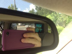
I also noticed two interesting things on the drive back.

The first is: if you take a sip of your Mellow Yellow at Unicoi Gap and close the top, your Mellow Yellow bottle will be deflated in Cleveland.

Deflated Mellow Yellow

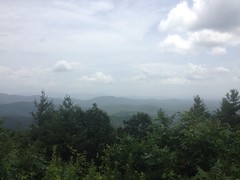
Also, all day it had been rainy and sunny, cloudy and clear. This chaotic weather ultiamtely produced a tiny little rainbow over Long Mountain.
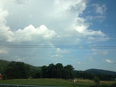
Tiny Rainbow

Teeny tiny.

Well, I had a good time, but, in fact, I failed to accomplish my primary goal. How unfortunate. Terrible! Though, I now have yet another excuse to go running around up there. And I shall. Until then...