Some months back, right after we finished that second leg of the East Texas Trail, my Dad was telling one of his customers about it, who also rides, and the customer mentioned the Lake Ray Roberts Greenbelt to my Dad. My Dad sent me a map, and it looked pretty interesting. Basically there was this long unpaved greenway type trail, with a park at the halfway point, which had 10 or 15 miles of singletrack. It wouldn't be an all-day epic, bit it ought to be a pretty good day.
We figured we'd get to it as soon as we had the opportunity.
[Many months later...]
We had the opportunity!
I forget which day it was, but it was some day in the middle of the week, not long after we'd ridden Tyler. We headed up to the Denton/Pilot Point area for Adventure.
We're pretty well practiced at the logistics of point-to-point rides by now. Get up early. Eat eggs and pancakes. Load the bikes onto his car. Drive to the end. Drop my truck. Drive back to the start. See interesting scenic small town Texas along the way...
Go!
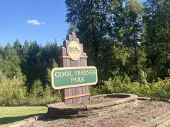
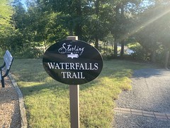
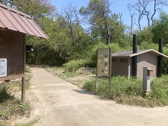
Except there was less "Go!" this time. We'd planned on parking at the aptly-named Greenbelt Corridor Park on the south end. The park was there, but there were barricades up and "Area Closed" signs. The chain between all of it was super new too, like it had been put up the previous weekend or something. There was construction going on along the road there, so I wondered if maybe they were going to have that lane shut down and they didn't want people to park down there and get stuck.
We parked next to the barricade and I jogged down to see what was what.
Ahh... It looked like it had super flooded recently. Like the parking lot must have been completely full of debris. The lot itself was now pretty clean, but you could see that it had been cleaned up:
There were huge piles of tree-debris on the northeast corner.
And the bathrooms, trailhead signage, and trail itself looked ok.
I guess it had been closed, cleaned up, and just wasn't back open yet. Or maybe that AND the road construction.
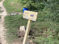
I'd seen this a dozen times though - for some reason the lot is closed, but the trail is still open, you just can't park there. The sign said "Area Closed" which we interpreted as meaning the parking area, parked down the road at the local city hall, and rode back to the park. It turned out that it was over 2 miles back to the park, but it was almost all downhill and didn't seem like very far.
I managed to get my lower water bottle caught on the chain lifting my bike over it, which moved it as I stepped over it, which tripped me, and I have no idea how I managed to save it, but I ended up uninjured, which was good, I guess, at the very beginning of the day.
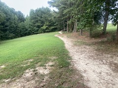
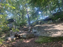
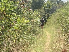
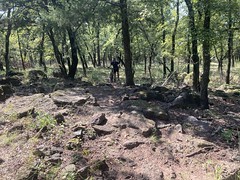
The trail itself was mostly fine.
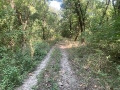
It looked a lot like some of the good sections of the East Texas Trail. Very near the parking lot you could tell that some trees had been pulled out, and there were tire tracks from some large vehicle, but whatever cleanup had occurred, it had occurred some time ago. Further on, it looked like it hadn't flooded recently at all, and we were making really good time, just buzzing along.
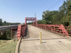
Then we ran into this totally enigmatic thing:

That's a concrete bridge, blocked by three rows of wood and chain-link fence on the far end.
???
The trail beyond looked exactly like what we'd been on. I checked the map vs. our gps track. We weren't off route or anything. That WAS the greenbelt ahead of us. Was there some terrible blockage ahead that they didn't want you riding into? Did the land get recently sold and become private (this happened at Rowlett recently)? There weren't any signs, No Trespassing or otherwise, just this blocked bridge.
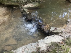
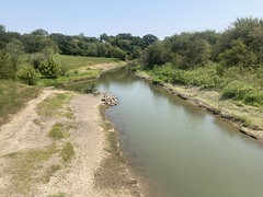
The bridge itself looked sound. There was no obvious way around. It crossed a ravine, a feeder of the Trinity, and the water was deep and wide. It was very still, and still water is deep water.
Hmm...
It looked like we could finagle our way around the left hand side of the chain link. We'd have to kind-of drop over the side of the bridge onto the slope next to it, and it would be really tough getting back up if we had to, but it could be done.
We were like 5 miles in, we really didn't want to turn back and then have to take 7+ miles of road around to the next trailhead.
We debated for a while, before finally deciding to go around the fence, then be cautious until we could figure out what we were being blocked from. Who knows, maybe the trail was totally blocked, or there was a sinkhole or something...
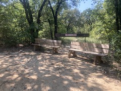
Not 500 yards later, we saw benches and another wooden barrier.
????
And beyond, a very well worn trail with tons of foot prints, tire tracks, and hoof prints. And it was well marked:

?????????
Looking back behind us, it suddenly became clear.
I'm not sure how we didn't figure this out to begin with, but we didn't.
The area between there and the parking lot that we couldn't park at was all closed. On the south end, they put up barricades. On the north end, they blocked the trail, but I guess people kept going around it, so they VERY blocked the bridge.
The trail ahead was totally fine to ride. It was what we'd ridden already that they didn't want us on. I guess maybe in the past it was impassible or something. It was certianly fine to ride at that point. No idea.
We pressed on.
The next leg of the Greenbelt was perfect gravel.

It was that small gravel that everybody means when they talk about "riding gravel" out west, or up north. Not that big chunky Georgia gravel that I'm used to. It was a pleasure to ride, and we made really good time on it. We kept alternating between woods and hay fields too, and there were huge bales everywhere, bundled up and ready to go.
At length, we passed under a road, looped around near a parking lot, and encountered the Elm Fork Bridge, which was, at one pont, and for a long time, a bridge for vehicles.
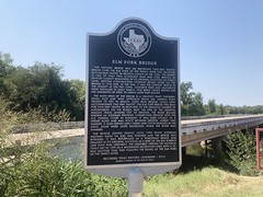
We'd been riding along the Elm Fork (of the Trinity River) all day so far. It had been off to our left. We now crossed over it and continued with it on our right.
There was more of that same, pleasant gravel along that section, and we rode many more miles of it, and passed through many more hay fields, before finally approaching another parking lot.
Apparently, we'd diverged from the Elm Fork at some point, and now crossed it again, perpendicularly.
At the lot, we drank and drank, and filled up our bottles. It was quite hot, but it was also very dry. Neither of us were just pouring sweat like we were accustomed to doing. Neither was it that hot breath wind that I usually associate with dry heat.
Incidentally... I recently discovered the source of the phrase "hot breath wind". In high school, in Baton Rouge, it was a kind of common saying among friends of mine, describing dry heat, where you don't sweat, but the moving air itself doesn't feel like it's cooling you off. We encountered it many times on trips to Texas, and it got said quite a bit. Actually, it was more often "hot breaf wind" as they were prone to mispronouning it for comedic effect. But did one of them come up with it? I always thought so, as I had not heard it prior, and they all said it. Turns out though, in the movie Dragonslayer (1981) one of the characters refers to dragons as having "hot breath wind". I ran into a DVD of that movie at an antiques store in Forney later during that same trip, watched it when I got home, and recognized the phrase. So, ha! That's where it's from. I now wonder if they knew that it was from that movie, or if it was just in the back of one of their minds, or if they heard it from somewhere else, etc.
And, while I'm on the tangent of the source of phrases... I have said "All's well that ends" many times, usually referring to something that was good, but is now over. Sometimes attempting to cheer myself or others up about it. Not "All's well that ends well", which has a different meaning, but just "All's well that ends". I've even used it before on this blog. I'd heard it somewhere. I didn't remember where. Google wasn't helpful. A few months ago I ran into the source again though. The band Jibe (from Dallas, no less) has an album called "Live at Trees" (1994) recorded in Deep Ellum (in Dallas). The first song is called Victimless. I can't find the lyrics online, but in the first verse, there's a line "All's well that ends, you say..." Ha! That's where I must have heard it. Incidentally, my copy of Live at Trees is just titled "Live" though it does say "Recorded at Trees" off to the side. I'm not sure if they're all like that, but I bought mine out of the trunk of their car after seeing them at a show in Ruston at The Que Stick in like '94 or '95 on their local tour, promoting that album, so maybe mine is an early version.
But enough digression...
Like I said, we drank and drank, and felt cool and refreshed afterwards. I then attempted to get back on my bike, slipped off the pedal, went diving over it, somehow (again) managed to not completely eat crap, and though I thought I'd done some damage slamming it into the sidewalk, ended up only barely scuffing one grip.
Smooth move, that one.
Across the road from the parking lot, we could see the massive wall of the dam that formed Lake Ray Roberts. The next section of trail, from that lot to the park, didn't seem like it could be very long. I mean, the lake is right there, and the park is right on the lake.
Heh.
It wasn't all that long, but it was very popular horse trail, the soil up there is quite sandy, and it's not super flat. Sandy soil has a low shear strength. Low shear strength soil gets chewed up by horses. If it's hilly, it all runs downhill, and after many, many years, anywhere it's not perfectly flat, or even where it is, but it's at the bottom of a hill you get deep, deep sand:

So much sand. It was like riding on unmaintained roads in Florida. You can kind-of get through it, if you can keep your momentum, but we both walked, a lot.
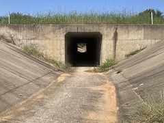
At great, great length, we passed under the road that crosses the dam.
The character of the trail changed quite a bit there. It was much more rocky than sandy. I mean, there was still sand, but not nearly as much, and the trail just generally felt rocky.
I figured we'd be at the park road and minute now... for like 20 more minutes.
We did start seeing some indications though. There was an old chimney along the trail, fenced off, with an interpretive sign.

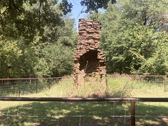
That has to be in the park, right? And there were some side trails, that were hike-only, and I remembered that there was a nature trail near the park.
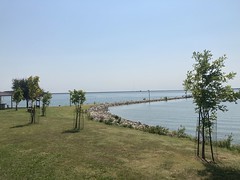
Ha ha! Soon enough, we teed into the park road and took it down to the lake.
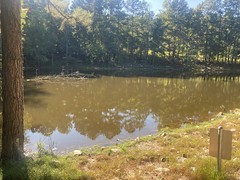
The lake:
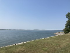

Apparently they're having a problemwith Zebra Mussels in that part of Texas.

Don't even scrape them off your boat. Call DNR first!
Again, we drank and drank, and filled our bottles. The Dorba trailhead was close by.

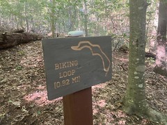
And it was singletrack for miles and miles.
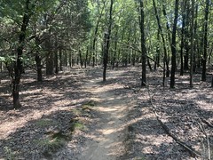
Ahh, flowing, purpose-built trail. Much nicer than sand.
The trails were a stacked loop - A, B, C, D, and E. Each progressively longer. Allegedly, D was the most challenging, but there were bypasses. We made pretty quick work of A, B, and C. We saw D's bypasses and took those as well. Loop E provided good views of the lake, as promised. The trail was a bit like Lindsey park. Kind-of sandy soil. Kind-of rocky. Reasonably flowy. Arguably more so than Lindsey, but I don't mean to judge.
About halfway around E the trail started getting pretty chunky. Then it calmed back down. Then it got chunky again. That time, Dad has to push.

Then it flowed all the way back around to D.
I don't know if there was a bypass that we missed, but I didn't see a bypass. The entire return leg of D was super, super chunky. Like if you took the Dug Gap Pinhoti and wound it around North Dallas. The Dug Gap Pinhoti has specific steep, long climbs, so it didn't have those, but it was about the same, other than that.
So much chunk.
There were several sections that I just didn't see a line through until looking at it for a while.
Pretty awesome trail actually!
However, it was getting much hotter. I'm not sure how hot it got, but it was hot, getting hotter, and we were drinking. Right as we got back onto C, Dad ran out. I had maybe half a bottle left. No big deal, C was nothing compared to D and E. Well, yeah, on the out leg. The return leg was like 15% less chunky than D, and I swear they got 4 climbs out of every hill. There were places where you could look over and see where the trail ran back down, back up, and back down again. People definitely cross-cut those, but we didn't want to do that, so we shared the last bit of water that I had, and pushed through it. B was much faster and smoother than C, so we made good time there. We ran out of water just before hitting A, but A was like a quarter mile of trail or something, so we made it out.
Again, we filled our bottles, drank, and drank, and got as recovered as we could.
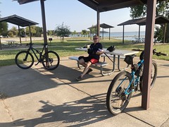
There were weird dirt dobber nests above us in the pavillion we were sitting under.
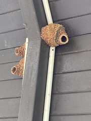
The different colors of clay were pretty awesome.
We probably stayed there for half an hour. I drank at least 40oz, and my Dad drank at least the same. He had to take a work-related call while we were there, and he kept telling them: "We can talk about it, but I've been riding for the last 4 hours or so, and we ran out of water a few miles ago, I'm getting rehydrated now, but I'm not sure this is the best set of circumstances for me to be making work decisions..."
Heh heh, yeah. To say that we were addle-brained for a while would be an understatement. After a half hour though, we felt pretty recovered, and set out on the last leg.
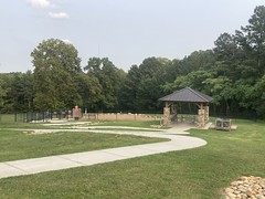
We took the pavement back to where we'd crossed it, and picked up the Greenbelt to the north. A few hundred yards later we were in the most elaborate horse lot I'd ever seen - the Bluestem Grove Equestrian Camping Area. It had every ammenity you could imagine. I'd never seen such a thing. I'm used to horseshoe turnouts on either side of the road, and maybe poles to run tie-lines between. I had no idea anything existed other than that.
It took a while to find the Jordan Park Trail, but we did, and took it north, in the direction of Jordan Park.
It was clearly a popular horse trail, but it was flatter, and the soil was less sandy, so while it was a little rough, we could move a lot faster, and never had to walk.
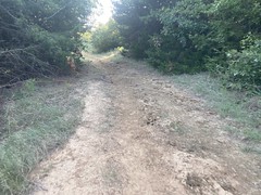
The further north we got, the rougher it got though. It looked like it had gotten pocked after the recent rain, the mud had rehardened, and just hadn't gotten crunched down again since.

We rode that for several miles. Occasionally it would get grassy, but not for long.
We couldn't find a place to park at the VERY far end of the trail (though later I found a map that showed a place that we could have parked), so we parked in a lot off of FM1149, which was a few miles south of what I thought was the end, at the time. We figured we'd pass the truck up, ride that tail end, then loop back to the truck.
Well, after riding those last bumpy miles, we decided that we'd had an adequately satisfying experience on the Ray Roberts Greenbelt. Unless it was notably better across the road, we'd just call it a day at 1149. When we got there, and crossed the road, the trail surface was about the same, but the trail narrowed down, and we started having to push through tall grass. This went on for a few hundred yards, and we were like: "Nope, not any better!"
Done!

We loaded up the bikes (mine on the roof because my hitch rack only holds one bike), and headed south. The drive back was pretty uneventful. We were still a little keyed up from the ride. It had been fun. It had been tough, but very little of it had been a terrible slog.
Adventure!
My Dad's car was still there when we got back, so we got changed and grabbed dinner at The Prarie House in the town of Crossroads, a little bit East of where we parked. I had a Bison burger, and it was excellent. My Dad had a regular burger, and it was (allegedly) also excellent. There were mounted trophies of every animal imaginable on the walls. Dallas was playing somebody on TV. It was satisfyingly Texas.
When we walked outside, it was actually cool, or at least it felt cool. Surprisingly cool. Fall's coming!
When I got back and crunched the GPS data, it looked like there was a way to bypass the chunkiest parts of D, we just missed it somehow. There's also a paved trail that runs around the park. I could imagine parking at Wildcat Road, riding the officially open greenbelt up to the other lot, taking pavement into the park, riding the Dorba trail (including the bypasses), riding the paved trail, then backtracking back to the car. That would be an even longer day, but might be a more fun ride.
Hmm...
HMMM!