Mark Baldwin called me Friday afternoon, inviting me on 50-odd mile expedition into the Piedmont National Wildlife Refuge with him, Hirsch, Namrita and The E. The last time I did a long ride down that way was one of the best rides in recent memory. In fact, I think my exact words when contemplating another such ride were "I'm in if you do it again." Those words were directed at Chris Tavel but they might as well have been directed at Mark because he's the one that actually invited me on that ride. Friday, he was inviting me on another, and true to my word, I was in.
Saturday morning, we met at Hirsch's place, or out front of it at least, and carpooled south to the land of giant peanuts...
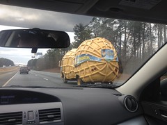
...and fried green tomatoes.
Juliette GA, made famous by the movie Fried Green Tomatoes which was shot there. The producers turned a local hardware store into "The Whistle Stop Cafe" from the book and it's still there today, fully operational, serving the same fried green tomatoes that they served in the story. I saw the movie when I was a kid and I remember thinking that it was generally awesome. I don't really remember why except for some part about an abusive husband that either disappears or was made to disappear under suspicious circumstances. Maybe I should watch it again. I bet it's on Netflix.
At any rate, that's where the ride started, Juliette, GA.
We parked at the Monroe County Recreational Park, from which you can see the old Mill and part of the mill dam machinery...
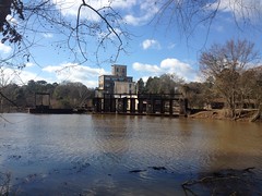
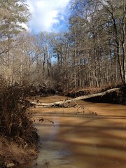
...but unfortunately cannot see the dam itself, which stretches across the width of the Ocmulgee river. From the side we were on it just looked like the edge of the world. I caught a brief glimpse of the other side later, but only a brief glimpse. It was massive and stunning though, so I may have to go back and get a better view some day.
Eddie and Nam brought their dogs along with them. They've had two dogs for as long as I've known them - Jackson and Porter, both German Shorthaired Pointers. Porter was always calm and reasonably well behaved. Jackson was always excited and tied himself up in his own leash every few minutes. Last year Jackson died of cancer and even I, who only saw him randomly, found myself sadder than I expected to be in the days after hearing about it. Really, I guess I was mostly sad for Nam though. They were her dogs from way back and you couldn't spend any amount of time around them without being able to tell how much she loves them. There's a big hole there now, I think. Porter was with them on Saturday, as expected, but they had a new dog too, named Bailey. Bailey is another German Shorthaired Pointer rescue and I think they're fostering her for now, or something. This time, Bailey was the well behaved one and Porter took off after his nose as soon as the car door was open.
Oh man! Dogs. Dogs! Kathryn's allergic and I don't get enough time with dogs.
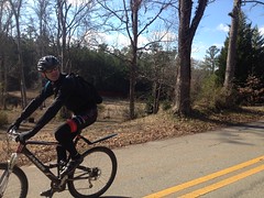
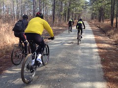
The dogs were fun to watch but we were actually there to ride mountain bikes, so we did get down to that eventually.
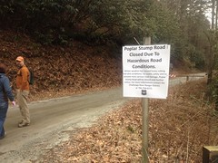
The route we planned to follow was called The Fried Green 50. Somebody organized a ride along the route years ago but there was some conflict with something else on the same day so I put it off, and then there was a conflict the next year too, so I put it off again, and I don't even remember what else has kept me from doing it since then, but it's apparently fairly well established now. There was a flyer for the 2014 ride tacked to the pavillion at the park.
We started off across the Ocmulgee, hung a right and passed some pretty impressive old waterworks ruins. There were some old houses along the road there too. Some still maintained, others less so.
Hirsch had some problem with one of his cables rubbing on his tire but he fixed it somehow and caught right back up.
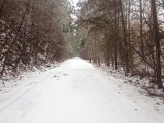
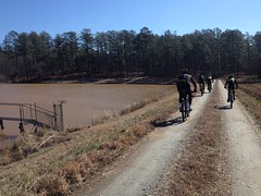
Before long we were on dirt, riding into the refuge.
The terrain was a lot like the Oconee had been. In fact, we were only a few miles south of it. We were even set to cross some of the same creeks that we'd crossed last time, just further downstream. Between the Oconee and the Piedmont, I'd bet you could put together a 100 mile dirt route pretty easily. Hmm...
(Update: I guess I'm more geographically challenged than I thought. The Oconee that's a few miles north of Piedmont is a totally different section of the Oconee than the one we rode a few weeks ago, and the creeks, while bearing the same names as the ones in the other Oconee, are, in fact, different creeks. Woohoo!)
We passed a guy out hunting turkey or grouse or something. His dogs were running around, having a great time. He was all waves and smiles too, so I guess we were all having a good time.
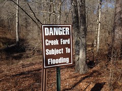
The idea of being able to hunt in a "Wildlife Refuge" struck me as a contradiction in terms and I joked about it a bit. I guess the idea is to provide a refuge from the impact of land development though, as opposed to hunting, fishing or recreation, and we'd passed a sign earlier about needing a permit to hunt. It made sense, but it was still a little funny.
So, like I said, we were all just riding along, looking around, having a good time... And then...
Ha ha ha!!!!
And they weren't kidding.
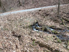
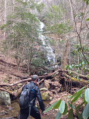
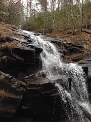
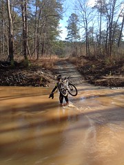
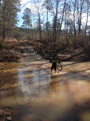
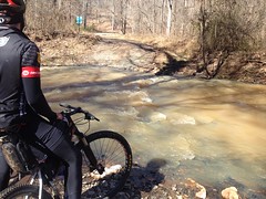
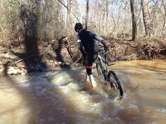
It was Falling Creek, the same one we'd crossed on the granite with the picturesque little waterfall off to the right in the Oconee. This time it was deep and raging. Go ahead and try to ride across, it'll sweep your wheels out from under you.
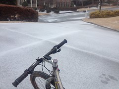
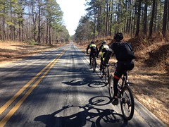
It was sunny but still in the mid-30's. We'd decided to stay on the forest roads and ride south of Atlanta to avoid the melting snow and ice; in effect, to stay warm and dry.
The irony!
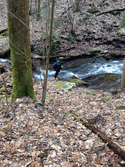
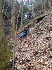
Only one way that I know of to cross. I've done it before, many times, in worse conditions, and I was kind of looking forward to it, as it would neatly place this ride in the Adventure column. It didn't seem like a good idea to anyone else though. Not a good idea at all. I figured I'd better just go for it, once I was committed, they'd have to follow.
Nam took my camera, presumably to document my stupidity.
Here goes nothing.
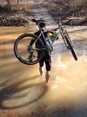
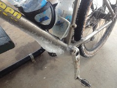
It got deeper that this even, I wished I'd rolled my knee warmers up a little higher.
Ha!
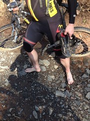
I made it! No problem. I even had a little camp towel to dry off with. That meant that everyone else had to cross too.
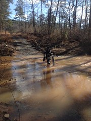
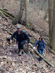
Eddie thought hard about crossing on this tree...
...but, wisely I think, decided against it.
Baldwin got the award for hiking his shorts up the highest.
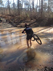
He might have had the right idea though, the rest of us ended up getting a little bit of either shorts or knee warmers wet.
Nam was the last to cross and later admitted that she did so only after waiting to see if someone else would volunteer to carry her or at least her bike across. Ha! Yeah, fat chance of that. She did get the award for best looking toenails though.
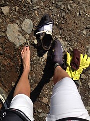
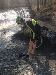
Between the rocks and the cold, it does kind of hurt your feet to cross like that barefoot. Marc was mentioning that when he was a kid, he was always jealous of friends of his who had what they called "Indian Feet", to which Eddie replied "Nam has Indian Feet." Ha ha! Yeah, I guess so! The whole day we were making odd little jokes like that. We laughed a lot. All of us. It's one of the things I love about riding with those guys.
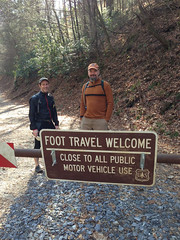
So... Traumatic events behind us, we pushed on, deeper into the Piedmont. There were dozens of gated roads to either side but every one of them was marked "Foot Traffic Only". I might have seen one or two trails but they were marked the same way. The Piedmont isn't part of the National Forest, and the rules are a lot more restrictive. You can't be in there at night at all, you can only ride bikes on the roads and you have to have special permits to do just about anything else other than hike. I'm not sure you can even hike cross-country without a permit.
No problem though, it was exactly what we were looking for. Several of our crew were training for the Huracan. Mark and Eddie were carrying various gear bags. I'd decided against bringing my Huracan rig this time. I didn't need to do any gear tests. I know my rig pretty well and I'm not going to be able to ride the Huracan this year anyway. More than that though, I'd only managed a few hours of sleep the night before and I wasn't sure how good I was going to feel. Lighter seemed like it would be better.
In addition to his bikepacking gear, Mark also brought some blinding white shoe covers.
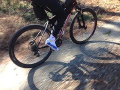
If you were behind him, between them and the white stripes on his seat stays, if the sun was behind you too, you couldn't even look down or it'd mess with your eyes.
Aside from Mark's blinding whiteness though, everything was going well. The roads rolled gently. They were soft sometimes too. Not sandy, but you had to work to keep moving. All-in-all, not a bad approximation of Florida. Maybe a little more climbing, but pretty good. We were moving, everyone was happy again, just riding along, looking around, and then we hit Allison Creek. Ha ha ha! Yes! Let's do it again. "You know the routine." It probably took 15 minutes to get everyone across the creek but we were getting better at it, more confident, and faster. This time there wasn't a big rock on the other side to sit down on though and my chamois sponged up an uncomfortable amount of sand and water from the roadbed. It was funny, the part of the process that got me most wet wasn't wading through the raging water, but rather sitting down afterward to get dried off.
Onward!
At some point the GPS track looked like we needed to go right on a paved road, but really we had to jog left into the Little Rock Wildlife Drive and then hang a left that paralleled the road. The Wildlife drive had a bunch of interpretive signs and stuff to either side and it wound back on itself over and over, around and through a really scenic little corner of the refuge, across ponds and creeks and in and out of little hollows.
The hills in there were the steepest of the whole route and I struggled pretty hard. I was really feeling the lack of sleep and I couldn't get recovered well enough between the hills. A few times I had to fall back and then punch it to catch back up and it made me a little worried because we were well under half way through the ride.
The next section was a few miles of pavement though. I ate a little, sat on, and did manage to get fully recovered.
From then on, I felt great.
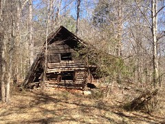
We passed traces of former occupation. Here and there a giant oak stood next to the road with trees cleared around it and a little bit of grass trying to grow. Sometimes you'd see a lone chimney set back off of the road a ways. Near Caney Creek though, there were some much more impressive ruins.
An actual log cabin.
And a slightly more modern house.
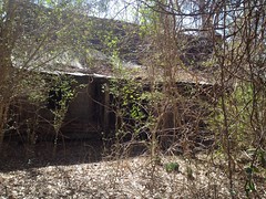
And some other collapsed old building across the road.
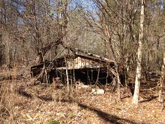
Kathryn would have loved it, but I don't think she could have resisted trying to go inside.
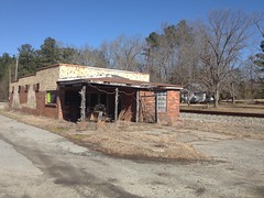
The ride moved on. The hills didn't seem so steep or so close together any more. I was doing alright. We hit some pavement again, briefly near the community of Round Oak. Aside from a church and this old rail depot, or whatever it was, there wasn't much there.
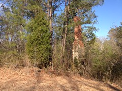
Back in the woods, we passed this strange thing.
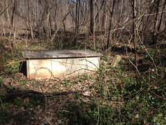
What is it?
It kind of looked like a tomb, maybe, but it was very plain for a tomb. In the end, all we could say for sure was that it was an unusually ornate box, out next to the road, in the middle of nowhere. The USGS maps call it "533", though I think they're referring to the concrete post next to it. Weird.
Eddie had remarked at various times about the lack of downed trees. Given the ice storm we'd had earlier in the week, he'd expected at least a few. We hadn't hit any yet but soon after passing that weird box we got into them. They were all spindly little pine trees though. I think there was one I had to dismount to get over. There was one that was really low but clear underneath and it looked like if you got over on one pedal and ducked down really low and were really careful you could limbo under it. Baldwin tried and ended up getting jammed in and falling over right underneath it. So close! Oh, man it was fun to watch though. I was actually kind of hoping he wouldn't make it because I was right behind him. I'd have had to try if he made it and I wasn't sure I could get under.
We rode by fields and more ponds, through forests of pine and hardwood. We hopped downed trees. We climbed, we descended. All in all, we were making very good time. Our pace was a lot higher than the ride in the Oconee. It was difficult to take pictures.
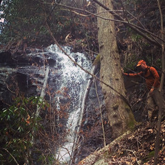
Eventually we hit Falling Creek again.
I think "Aw man, do we have to?" was the predominant sentiment.
It looked shallow but waves clearly evidenced large rocks in the ford. Eddie wasn't hearing any of that large rocks crap though, and just rode on in. He had to ratchet but he made it most of the way across. It looked like the force of the current drug his back wheel over and he got hung up on something. Whatever it was, he got soaked and had to walk the rest of it.
The rest of us forded as we had before.
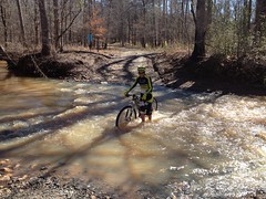
The water was a lot warmer than it had been those previous times, at least.
A few miles later we had to cross another creek. I don't remember which one. I was even tired of it by then. Then a few miles later we hit yet another one, but it was low and ridable. Nam blew through it really fast though and got more soaked from the spray than she'd gotten in any of the previous crossings.
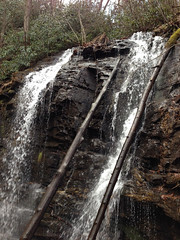
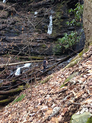
There was a short section of road we had to backtrack on and then we had to do a loop off of it that should put us back really close to the cars. We passed a nice waterfall just upstream of a bridge before turning onto the loop but nobody seemed into slowing down to take photos. One day I'm going back just to take pictures of stuff, damnit.
The loop was anticlimactic. The GPX track showed it going straight ahead but the road ahead was closed to bikes. It looked like we could walk about a mile and then hang a hard left onto some other road, but we couldn't be sure that the other road wouldn't be closed too. Without knowing the route, we could be walking for 5 or 6 miles even. Plus, who knows, it could be like the Wilderness where you can't even possess mechanical transportation. What did they do during the group ride? Poach the trail? Was it open to bikes at some point in the past? Do they get special permission? Grrrr. The other option was to hang a left and see where the road that we could ride went. That's what we did. It just looped back to the main road and cut a few miles off of the route.
Woohoo! Fried Green 50, or Fried Green 47.5 I think was our final distance. When we got back to the cars, they let the dogs out and we had to corral Porter to get him back in. Eddie would tell him to go back to the car and you could tell watching him that he meant to, but it was far enough back that he'd get distracted on the way and go off in some other direction.
We topped the afternoon off with a visit to the Whistle Stop Cafe.
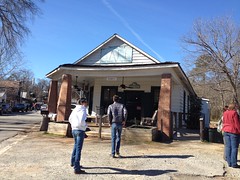
The waitress remembered Nam and Eddie from the last time they were there. The food was exactly as good as I'd hoped it would be. I stuffed myself and cleaned my plate. I did pass on the fried green tomatoes but everybody else seemed to like them.
Oh man, oh man! What a ride. I took a nap for like 3 hours when I got home. You know it's a good ride when you have to take a nap afterwards. I only woke up when my brother called me. It was fortunate too because I had some work to do and I'd have been up pretty late doing it otherwise.
Today I've been working all day. It's just as well though. I've got that relaxing whole-body-tired that makes a desk job feel good. Plus, I'd have compared anything I might have done today with yesterday and it might have paled. Work, work, work instead. Hmm. Speaking of work, I'd probably better get back to it. These bills aren't going to pay themselves.