Saturday, February 20, 2016

Noontootla

Woohoo! I'm really getting this backlog knocked out. This one I remember reasonably well, I think.

It snowed in Atlanta for a few hours during the week prior to the 23rd of January, and the mountains got quite a bit, it turned out. Billy was actually going to be in town that weekend, so we coordinated to put in a couple of ice-and-snow miles.

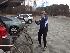
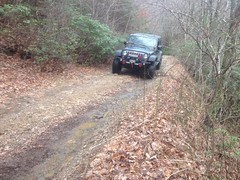
We met at my place fairly early and I was all "So, what kind of experience do you have driving in the snow and ice." and he was all "Oh, I've been working up in Canada for a month, so that's just about all I do." (or something to that effect) and so I was satisfied to let him do the driving. But then when we got on Big Creek Road and encountered unexpected, and extended patches of ice and snow, he was more like "Hmmm, I didn't realize it, but I guess in Canada, they get so much snow that they're prepared for it, and driving in the snow there is really not." We survived the trip in though, and there was only one time where I was like "...probably want to slow down going into this curve."

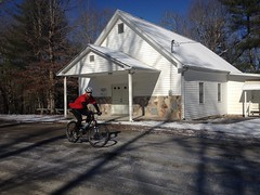
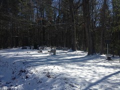
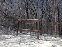
We parked near the Fellowship Church...

Fellowship Church

...and it's associated Fellowship Cemetery.

Fellowship Cemetery

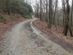
And began climbing Noontootla Creek Road right away.

Me and Billy Climbing

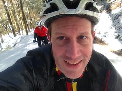
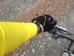
I had the good gloves on. I did wish that I had my old even-more-comfortable fleece-lined bib, but I wasn't uncomfortable.

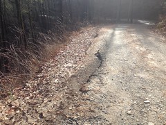
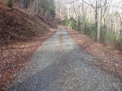
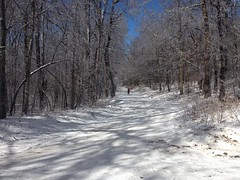
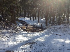
We climbed and climbed, and as we had started bright and early, the temperatures climbed with us. All the way up the road, there was a steady rain of little bits of ice and snow, falling out of the trees. Whenever a sunbeam hit the road, you could really see how steady it was.

Noontootla Creek Road

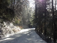
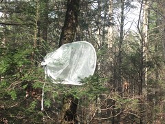
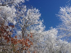
The road was frozen solid. The trees were flocked.

Flocked Trees

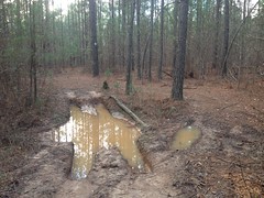
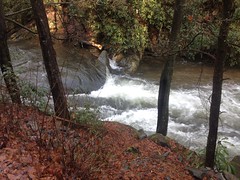
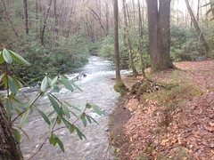
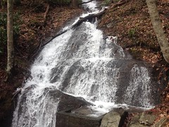
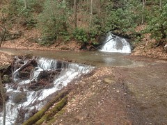
A few inches covered the ground in the woods. The creek was high and roaring.

It was just right. Just what I'd hoped for.

At Winding Stair Gap, I noticed the Blue Ridge WMA sign was missing.

Winding Stair Gap

Did they finally take it down for real? For like 6 years or more I've heard that it's no longer a WMA, but signs to the contrary have persisted for all that time.

I got a bit ahead of Billy at the top, near the gap, so I had an opportunity to capture his struggle.

Billy Climbing up to WSG

So is this conflict man against nature, or is it really man against self? My high school English teacher would ask.

At Winding Stair we hung a left and rode along the ridge up there. The sun was out, so there were patches of light and shadow, and the consistency of the ice and snow varied greatly. At one point, there was a spot where water was running across the road, and there was a gap in the ice about a foot across. Billy either didn't see it or didn't think it was dangerous, and had a Clif Bar or something in his hand when he ran into it. He hit the ground faster than you'd think gravity could pull him down.

It was amazing to watch. He wasn't injured per-se, but did manage to cut his face on jagged bits of ice, I imagine.

Billys Crushed Face

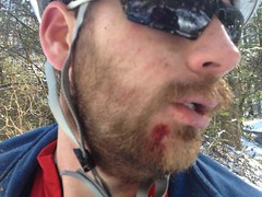
He didn't notice it at all. Apparently it didn't hurt. Eventually when I told him, he asked what part of his beard the cut was in, which seemed a funny way to ask the question. It was actually even funnier too, because he managed to cut himself in the one spot where there was no beard.

I leant him my technology mirror to check it out and he seemed pretty impressed.

Then he crashed like 2 more times between there and Hightower Gap. Goodness man! It was all because of the inconsistency in the ice. It would be super solid and grippy, then become slippery, then get soft, and then become slush, all in 100 feet. All you have to do is catch a spot you didn't predict and bam, you're down. Fortunately, it's not like crashing on gravel. It crunches a bit, and you slide a bit. He was uninjured in his subsequent falls as well. I don't think he even got wet.

On our descent off of Hightower, he was substantially more cautious and managed not to crash again for the rest of the ride.

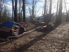
We ran into a surprising number of people for the conditions. There was a family at Puncheon Gap, sledding down the road that leads up to Hawk Mountain. People were fishing, of all things, in Rock Creek. A few people were camping. A few were just out driving around.

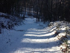
It was a good bit colder on Rock Creek Road, and the steady spray from the road didn't help. I teetered on uncomfortable for most of the run along that road. When we got back into the woods toward the north end of the loop and it got even colder, I was actually more comfortable. The snow and ice were a lot less damp, and we welcomed the climbing.

Old Rock Creek Road

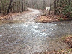
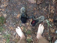
I was a little concerned about how high this creek would be.

Creek Crossing

Turned out it was fine, but at the time, I wasn't looking forward to either wet shoes or walking through it barefoot.

Near the Benton MacKaye we ran into some dogs. In the snow, I didn't hear their feet as they approached. I just suddenly had a pair of dogs pacing me, one on either side. They were friendly dogs. No barking. No attacking. I turned back to see if I could figure out where they came from, and discovered their owners back at the BMK, not even 50 feet away, but out-of-sight because of the curve in the road.

When we got back on Doublehead Gap road for the final run back to the car, it was probably in the 40's in the sun.

Laurel Creek Valley

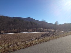
Most of the snow had melted in the cemetery when we got back to the car.

Some ladies drove by, backed up, and asked use for directions to Long Creek Falls. It was funny though, the one lady started with: "Do you know where you are?" To which I immediately thought: "You're in the jungle baby, you're gonna die...." but had the presence of mind not to answer with. Yes, I knew where I was. Yes, they were in the right place. Yes, they were still going in the right direction. It occurred to me though. Noontootla is like 15 miles off of Hwy 52. It's way back up in there, and Long Creek is probably another 4 or 5 miles up Noontootala Creek. All of that stuff is super familiar to me, but I imagine to the average sightseer, it seems really, really remote.

We had fun driving back up over Doublehead Gap proper. It was still icy on the lee side of the gap. We made it though, and so I guess that was the last bit of the Adventure.

It was great to get to ride with Billy. He travels so much these days that I don't get to see him as much as I'd like. It doesn't look likely to snow again this year either, so I was really glad to have been able to get the ride in. I'd have liked to get in some snow hiking too, but, sadly, it's looking like I'm going to have to wait a while for that.

Blankets Creek

More backlog... You'd think I'd remember this one well because it happened more recently than the past two, but actually, I don't remember much about this ride.

My folks came into town for New Years. My dad brought his bike and we got together on Sunday the 3rd for a ride at Blankets.

He apparently had some trouble with a glove in the parking lot.

The Padre Struggling With His Glove

Unfortunately, I don't remember much else. We rode 2 or 3 laps, I'm sure. I think we rode the new Dwelling cut-off.

It seems like we went home for lunch. I remember talking about presidential candidates or something on the way back.

Man, I wish I could remember more, but that's all I can recall :(

Gore-Subligna

More backlog... At least this one happened this year, right after new years, actually.

Living in Cobb County, the west side of North Georgia is actually fairly accessible. I really ought to ride in Rome and the whole Ridge and Valley area a bit more than I do. That was what I was thinking in early January when I headed up to the Gore-Subligna area for an into-the-night ride.

I charged my lights, put new batteries in my GPS, and printed out a couple of maps. There were some roads up there that were just dotted lines on my map, and some of them were allegedly dirt. My plan was to ride north along some unexplored roads, pick up the Pinhoti near The Narrows, take it back south, and then take some different roads back to the car. I also planned to ride into the evening and pick up the Pinhoti right at dark. Seemed like a good idea at the time.

I parked at the High Point trailhead, and immediately noticed new Pinhoti across the street.

Long ago, Pinhoti map showed the trail continuing across the road, winding around and picking up an old rail bed north of Starling Mill road. For years, and years, this was not the case though. The field across from the trailhead was fenced off and posted. Little-by-little, I watched the field turned into a stand of pine, but the fence remained. At some point though, it seems, the fence came down, and the trail running through the woods there became part of the Pinhoti.

Though it might add a mile or two to my route, I couldn't pass it up. From the looks of it, the Pinhoti appears to have co-opted an ATV trail.

Pinhoti Mud Hole

It got the job done, but it was just mud hole after mud hole. Tons of fun on a 4-wheeler, I'm sure. Kind of a drag on the bike.

Where it picked up the old railbed, I noticed a sign for The Great Eastern Trail nailed to a tree there.

The Great Eastern Trail

What the heck is The Great Eastern Trail? It turns out that it's a thing. Somehow I'd never heard of it. Funny what you can stumble into. Another day though, I had places to go and things to do.

The Pinhoti went the other way and I followed it as far as Starling Mill Road before picking up my originally planned route.

The road I took changes names a few times. It starts off as Poplar Springs Road, becomes Silver Hill Road, and then I don't remember after that, but it follows Taylors Ridge to the east. I think it leads up over Tightsqueeze Gap, but I might be mistaking that for a different gap.

At any rate, that's the road I took north. For some reason, I had decided that it was unpaved when I drew it on my map. Probably because the USGS quad from the '50's showed it as unpaved. It turned out to be paved, which was somewhat disappointing, as it was 8 miles long, or more.

There were some interesting ruins along the road though.

Ruins on Silver Hill Road

And a guy and his wife were out looking for their dog and asked me if I'd seen him, which, sadly, I hadn't.

And as the sun got lower, I really started to enjoy looking at the sky.

Sunset Over Taylor Ridge

It's funny, that photo looks nice to me now, but I remember being disappointed at how it didn't really capture what it looked like in person. I wish I could recall what it actually looked like now.

The temperature was around freezing, and I was a bit underdressed. Not badly, but enough to be like "Hmm, I should have worn the other gloves."

I stopped at the gas station at Hwy 100 to hit the restroom. Johnny and Norma and I had stopped at the same gas station during or TNGA ride way back. We'd spent the night at the Summerville Motel next door too.

Ahh... memories.

I continued north and it got dark about 4 miles later. On the road, I didn't need the headlamp. The little commuter lights were sufficient until I hit gravel in The Narrows.

It seemed substantially colder up there, and even after getting onto the Pinhoti and climbing tough singletrack for a while, I still needed to stop and put on my jacket.

The trail was more difficult than I expected it to be. I don't know whether it had just been too long since I'd last ridden at night, or what, but I was fumbling all over the place and it was terrible. I actually got off and pushed the last hundred yards or so up to Hammond Gap.

I needed to adjust the position of the headlamp, so I took off my helmet, only to find the power switch blinking red. Come on! I used to get 11 hours out of that lamp on its lowest setting, and like 3 on high. How could it be low already?

This was a serious problem. It was going to take hours and hours to ride the Pinhoti back, even just halfway, and I was certain I didn't have enough light for that. In fact, there was no telling how much light I had left. Maybe less than an hour.

Grrrr.

After consulting the map and deliberating with myself for a while, the only solution that would guarantee I'd be home by midnight was a direct abort - just turning around and riding directly back down the same road I'd ridden in on.

That's what I did.

God, it was miserable. Not because it was steep or difficult, but because I'd literally just ridden that road north, all 16 miles of it, purely as a means to the end of riding the Pinhoti back south. At least on the way north I hadn't known whether the southern end of it was paved. At that point, I knew that it wasn't.

Blah!!

Nothing to be done though, but knock it out. And I did, and it didn't take all that long. It did get a bit colder though. It was 22 when I got back to the car. 22 at night seems a bit colder than 22 during the day. Fortunately, except for my gloves, I was mostly good. My left shoe was still a little damp from Chimney Mountain, so my left foot got cold, but that was all.

I really enjoyed the heater on the way home. I distinctly remember that. I think I stopped in Rome for something to eat too. Zaxby's, I think, but I can't really remember now.

So, that was that ride. Just weird. Not much else. It's fun to have those though, so I guess I'm glad that I was able to.

Chimney Mountain

Goodness! The backlog...

It's been almost two months. I've been burning the midnight oil, burning the candle at both ends, and burning whatever other metaphors there are for working too much. Duty calls, and I've got too many pimps to pay. In all that time, I've hardly had a free hour or two. In fact, the only reason I have time now is because Sourceforge is up to something and I can't commit any of my code until they're done. So, I'm taking advantage of it.

Almost a month ago I rode Chimney Mountain. I distinctly remember it qualifying solidly as Adventure. I hope I can remember the details and relate them in a manner that does justice to the experience.

I remember that it had been raining, seriously raining, every day, for weeks. I figured I'd get in some gravel miles, as the trails would certainly be a mess, so I headed up to the Upper Chattahoochee as I am prone to do. The Chattahoochee was super high:

High Chattahoochee

Not that one can tell from the photo without another photo of the same spot for reference, but trust me, that's high.

There was some other guy ahead of me on the road in, and we ended up parking in the same little spot. He was from Birmingham, I remember that, in town visiting relatives, and had been a little discouraged by all the rain. He was optimistic though, about riding the Upper Chattahoochee, in much the same way I was. Seemed like a good choice to him too.

We'd both passed another rider on the way in. That rider saw us getting ready and came over to say hi. He wanted to know which way to go to get to Unicoi Gap. At that intersection, both ways get you to Unicoi Gap, but the scenic route was the way he'd been going. That was the way he meant to go, so he kept at it.

Right as I was about to get going, some guys pulled up in two trucks, roofs loaded with kayaks and canoes. With all the rain we'd had, the Chattahoochee was actually paddleable from there into town. It hadn't been in years and they were pretty excited. I wondered if it was viable to put in even further upstream, and there was apparently enough water, but too much deadfall since the tornado in 2012 (I think it was 2012) to make it worth doing.

I love getting little bits of perspective like that from other forest users, especially people out doing stuff that I don't do. I was already feeling good about the day and I hadn't ridden even 10 feet yet.

About a half mile in, a couple in a little Honda stopped me and asked me how much further the road was unpaved. Fortunately for them it was only a mile and a half more. They'd apparently gotten on just below Unicoi Gap, been on it for 14 miles or so, and had enough gravel road for one day.

I didn't run into any one else for a while. I remember that I felt pretty good too. I'd been climbing-in-the-mountains for the past few weekends, and it had been doing me some good.

The backslopes up there are really steep in a few places, and with all the rain, I expected to see a particular feature along the road. It turned out that I didn't have to look for long to find it either. Slump:

Slump

The hillside below the road had moved downhill an inch or two, and cracked up the road. That's one of those you-never-know kinds of things. They had a pretty massive landslide up there a few years ago that took out a few hundred yards of road. I'm sure it looked like this for a few days before it finally went. The whole hillside could go tomorrow, or it could firm back up never move again.

Climbing the road made me happy.

FS44

I felt a lot better than I had, even just a week prior. It didn't look steep to me. It had the previous week.

At one of the food plots, I'd seen some raggedy camping gear the week before. It was still there, and looked even more raggedy that week. Figuring it had been abandoned, I took a closer look.

Abandoned Camping Gear

Yep, the tent had been filled with garbage. Bags and bags of it. It was kind of weird too. I imagined a caravan of migrants, living out of their trucks, on the move, accumulating trash, camping for a few days, then dumping their garbage and old gear, and moving on. Who knows though?

Near the upper campground the river was still very high.

More High Chattahochee

It's usually a good 2 foot drop down to the water from the shore. Not that day though.

Oh yeah, the weather... The weather was nice. Unseasonably nice even. Low 50's. I was comfortable in my long sleeve jersey with no jacket, knee or arm warmers.

The Long Sleeves

Along Wilks Creek, I ran into an older gentleman. Quite a character, in fact. One of the recent storms had brought down some trees in one of the campgrounds, and he'd been able to cut a chunk out of one of them a day or two prior. The log weighed like 250 pounds though, he couldn't lift it into his truck, and he also worried that if he drove his truck down into the campsite to try, that it would get stuck.

He'd apparently just driven out there and hoped someone would come along and give him a hand. Lucky for him, I felt up for it, and it seemed like a good idea at the time.

The Log

We rolled the log up to within maybe 10 feet of the road, but the hill was kind of steep, and he wasn't up for manhandling it the rest of the way. It seemed like a bad idea to me, but he wanted to try to pull it up the rest of the way with a rope attached to his hitch. The rope ended up just slipping off of the log though, and it rolled all the way down past where we'd originally started.

Ha!

His dog chased it all the way down too, even got in front of it, and it was a miracle she didn't get run over.

We rolled the log back up to the same spot, chocked it, and got prepared to wrench it the rest of the way. Just then, a truck with two more guys passed by and he managed to holler them down to help out too. The four of us could just carry it, and the task was accomplished.

The guy had some Louisiana-themed tee shirt on, and when I asked him about it, it turned out he'd been stationed at Fort Polk for a while way back, and then lived in Alexandria for some time afterwards.

We shook hands and took off though. I kept climbing, and they actually did as well. It was funny though, they were in no rush. I was able to stay well ahead of them all the way up to the gap, on my bike, even stopping and taking photos along the way.

For example... I stopped to check out this weird thing that I'd seen the previous week.

Weird Semi-Permeable Tree Bags

There were a bunch of these semi-permeable bags zipped around the ends of hemlock branches. Probably 10 or 20 of them. ????

I stopped at the falls too, and topped off my bottles from the settling tank.

Falls on FS44

I want to say that there were some roadies heading the other way as I approached Unicoi Gap, but I don't 100% remember if that happened that weekend, or the previous.

Unicoi Gap

Bombing down off the back side of Unicoi was fun, but ever since I broke all those ribs, if I get into just the right position, my shoulder blade, or the muscles under it, or something, rubs on the site of the injury and catches. It's not painful, but it's uncomfortable, and tucking on the road seems to be one of those just-the-right-positions.

On Indian Grave Gap Road, there's a little house on the left, right at the border of the Forest. I've passed it dozens of times, but this time, there were a bunch of people milling around outside of it. I assumed the occupants. They waved. I waved. All those times I've ridden by, I've never seen anyone. It was neat to see them because it was different, I guess.

The ford was extra high, and there was no hope of ratcheting through it.

Ford on Indian Grave Gap Road

While it wasn't "cold" in the absolute sense, it was certainly cold enough to want to keep my feet dry, or at least not to ride 20 more miles with wet shoes.

So, it was shoes off for that crossing.

Shoes Off

Fortunately, that week, I'd remembered to bring all my goodies, including a little camp towel. High-five to myself for that foresight. My feet were nice and dry.

The climb up to whatever gap it is near High Shoals Falls was a little less difficult than it had been the week before, and I had plenty of energy along the back side of Rocky Mountain. I hadn't ridden Jasus Creek though, as I had the previous week. I remember debating with myself about whether I was actually in better shape, or whether I just hadn't worked as hard.

Rather than bailing down Tray Mountain Road though, I pressed on to Tray Gap. It actually started raining for a bit in there somewhere, and I wondered if the care I'd taken to keep my feet dry would prove shortsighted after all.

Wet and Rainy

Tray Gap is a popular destination for people who enjoy doing donuts in the middle of the road, and as a result, Lake Tray Gap now emerges after every decent rain.

Lake Tray Gap

The road past the gap is gnarly and deteriorated too, and a very popular spot for Jeeping. Years ago I drove my Durango all the way down it, and in 2010 or '11 I drove the Subaru as far as I could before getting blocked by downed trees. I'm not sure I could get either of those down it now. It was rough. Reminded me of FS28-3 on the west side of Nimblewill Gap.

This photo really doesn't do the road justice without an object in there for scale. That trench is 3 feet deep or more.

FS79

About 15% of the way down the road, I ran into a lady walking toward me in street clothes. She was a long way from anywhere though, and I didn't immediately understand how she could have gotten there.

Turned out her husband was a few hundred feet behind her in their Jeep, and she'd just gotten to where she'd rather walk than ride.

Jeepin on FS79

I must have passed 20 or more Jeeps and other trucks between there and the bottom of the mountain. Actually, that's probably a conservative estimate. It looked like that was the day to be out, and that was the place to be.

I was fairly impressed too. Most of what I looked at, I didn't see a driveable line through, but these guys had it, no problem.

I passed Jeep after Jeep after Jeep. Each successfully navigating something gnarlier than the last. I finally passed the last one about halfway down Chimney Mountain.

It was a lot wetter on that side than it had been on the other. There were several water crossings...

Water Crossing FS79

...and I managed to get my left foot a little wet.

But that turned out to be irrelevant soon after, as the wet spray soaked me from head to toe, including my shoes.

Descending FS79

In turn, the soaking turned out to be irrelevant, as the temperature was noticeably warmer at the bottom of the mountain.

I found myself in a rare situation too. There was a road to my left that I'd never been down before. Seizing the opportunity, I took it out to the highway, rather than just continuing directly downhill. The detour added a few miles to the loop, but they were some scenic miles, and I was happy to have added them.

It seemed to take an eternity to get back over by Unicoi State Park, and a second eternity to get back to the car from there. I didn't feel super tired, it just seemed like I'd discovered a never-ending road. Which is weird, because I've ridden it before. I don't know, I can't really explain it. Or maybe I could have a month ago, but it's gone from my mind now.

When I got back to the car, I noticed the other guy was long gone. I hope he enjoyed his ride.

I have no memory of dinner or the drive home. I remember feeling really satisfied though. If slow, I'd at least felt strong all day. I had that whole-body tired going, which I love. I'd met some interesting people, seen some interesting things, and managed some interesting conditions.

All-in-all, it had been the kind of ride that I always hope to have.