Tuesday, May 8, 2018

Upper Chattahoochee

I woke up Sunday morning feeling like I'd been run over by multiple trucks. Even close to 12 hours of sleep wasn't enough recovery for my soft IT body after the previous day's labor. Still though, I had a beautiful day ahead of me and I didn't want to waste it sitting around trying to get un-sore. Hair of the dog, they say. That's what I needed.

My legs actually felt fine, or at least, acceptably fine. It was my upper body that was really tired. Some gravel road climbing might be the right thing to do. No yanking the bike around, just sitting on and letting my legs do the work.

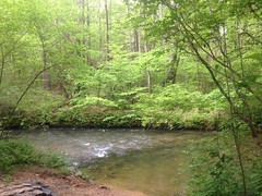
It seemed like a good idea at the time, so I headed up to Helen for some of that Upper Chattahoochee.

I think I remember making good time on the way up. I remember it seeming like it was hot outside too, but only on the highway. It was comfortable in the woods.

On the way into Helen, I noticed that the old Unicoi Turnpike south of town had been paved and turned into a greenway-type trail. I remember Clark mentioning that they were going to do that, but I didn't realize it would be done so quickly. On the way through town, it looked like there were a few upgrades too. They're building some kind of "mountain coaster" on the west side of the main street, and there was a new restaurant on the east side too: "A Slice of Helen".

I liked the name; it puns on both "A Slice of Heaven" and "A Slice of Hell".

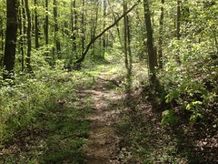
But I wasn't there for any of that. I was there for the woods, so I made my way into them, got dressed, and hit the road.

I felt great climbing FS44. My legs didn't seem to be any worse for the wear.

There were a gazillion cars on the road with me, and even several groups of folks just walking down the road. Not sure why that was the place to be, but it sure seemed like it was.

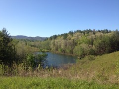
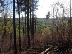
At 44B, I hung a left and ground my way up the Jasus Creek Loop. That climb is super steep. I'd forgotten how steep.

I'd also forgotten the views it affords.
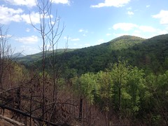
View From FS44B

Rare in Georgia.

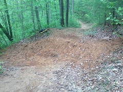
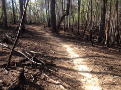
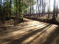
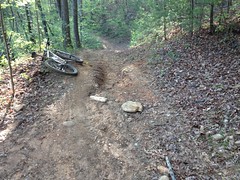
The climb is steep, but adding insult to injury was all the fresh gravel that had been laid down recently. My god, what a wrestling match. It wasn't that friendly little 57 stone either. This was big chunky 34, with little boulders here and there. I'd specifically chosen gravel roads to avoid working out my core. I couldn't have chosen more poorly.

There were bits here and there that hadn't been regravelled, but at least 80% of it was, all the way up to the top end.

They'd done a controlled burn up there too.

Controlled Burn

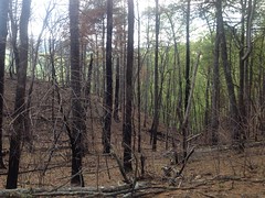
What struck me was how much unburned pine straw covered the ground. I'd think that dry pine straw would be specifically what you'd want to burn. I guess it fell after the burn? Maybe it fell because of the burn. I wonder if they'll have to do a second burn.

I didn't have too much time to think about it though, as I had to use most of my energy keeping from slipping out to one side or the other, bumping along on all that gravel.

There was less on the descent back to 44, but there was still enough to watch out for. Climbing on it isn't a lot of fun, but tearing downhill into a big patch of it is even less fun if you're unprepared.

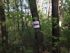
Back on 44, the tread was a lot friendlier. I climbed up to Vandiver Field, hung around the north end, and noticed a gate closed ahead of me.
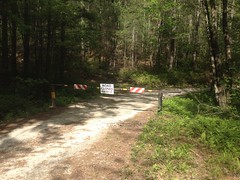
FS44 Closed

Interesting...

There was also this sign posted nearby.

Never Heard of This Before

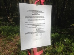
$5000 fine for entering a road, trail, or area of the forest that's been marked closed to the public...

I'd never heard of such a thing. My understanding is that foot traffic is legal anywhere in the forest. Non motorized traffic is technically legal anywhere, but strongly discouraged except on designated trails and roads, even if the road is marked closed. Motorized traffic is only legal on designated trails and roads, which are also marked open. There are rules in the forest plan about this. I double-checked them with Larry Thomas and George Bain way back.

The date on the flyer was 2013. Is this a new rule? Can you have one rule that contradicts another? Which one overrides? Can I not ride a bike on a road that's marked "Closed" any more? Seems really unlikely, considering the network of closed roads that are permitted for the TNGA and the closed roads that are just part of various trail systems...

Who knows?

It seemed like I'd either heard, or read about a recent landslide up there somewhere. Maybe that's the deal. Conflicting rules aside, if there were landsides ahead, I didn't want any part of them, so I turned around. I figured I could bomb back down, climb Martin Branch, and take the highway back into Robertstown.

But...

Gravel Wrestling Match

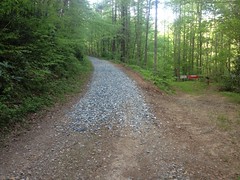
More gravel. Relentless, endless, perpetual, big, chunky, punishing gravel, from about 1/4 mile up, all the way to the top.

My God, it was awful. Literally exactly the opposite of what I'd hoped to be doing all day.

I think Martin Branch is maybe 4 miles long, but it felt like 10. I spun out and had to walk at least 5 times.

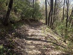
When I finally emerged on 44 again, it was a relief, and the climb out from there felt like riding on the Silver Comet.

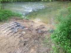
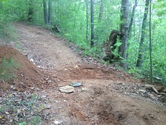
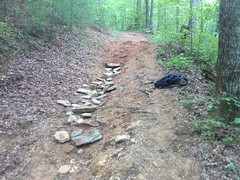
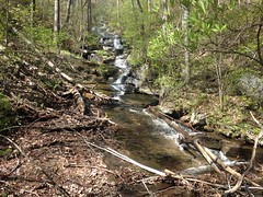
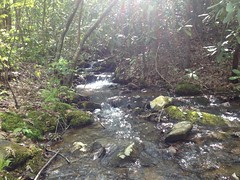
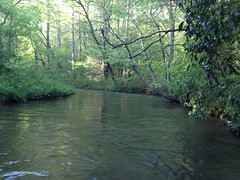
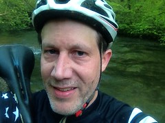
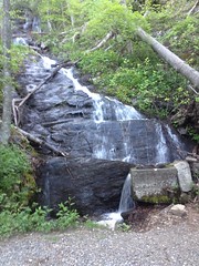
I stopped for a quick pic at the little falls with the settling tank...

Falls on FS44

...and then just up the road there was bear trotting towards me. It was a little slow to run away, and I almost had time to pull out my phone, but not quite.

I have a buddy who wants to see a bear in real life, and I've offered to bring him up to that area. We'll see if he takes me up on it or not, but that sighting reaffirmed my confidence that it's a good spot to look.

At the highway, the gate to 44 was also closed. Goodness. It's apparently possible to ride into the closed area without passing a sign that says that it's closed. Sorry guys, it was an honest mistake. I hope I don't get fined $5000 for making it.

A minivan passed me as I turned onto the highway, and I managed to stay within 100 yards of it almost all the way back into town, basically until the road started to flatten out and I was out of gears.

The run along the Chattahoochee back to the car seemed interminable. I guess I was just ready to be done at that point.

What a frustrating ride. Maybe the most frustrating ever. Crawling over shifting gravel all day ranks pretty low on my list of good times. I guess it's ok to do here and there, but that day, I just wasn't in the mood. The bear almost made it worthwhile, but not entirely.

I debated where to eat and ended up at that Slice of Helen place I'd seen on the way in. The restaurant is half smoking, half non-smoking, but the kitchen is in the smoking section, so the staff has to open the door between them over and over as they come and go. I'm sure it's much stronger in the smoking section, but it was pretty strong in the other half too. On the upside though, the waitress was friendly, and I got into a conversation with another customer about the location of Tiger Georgia. He was looking for "Goats on the Roof". Ironically there used to be one just north of Helen, but it closed a few years back. I'd seen the one in Tiger before. I think it's actually on 441 though, not in Tiger proper. Also, he kept saying "Tiger" but it sounded like "Taggart" and his wife had to say it before I could rightly understand what they meant.

I ordered "Sausage and Peppers" with no peppers, and it came out with onions and spaghetti (neither of which were in the description on the menu) and only 3 slices of sausage in the entire dish. Fortunately it tasted pretty good with a brick-oven kind of flavor, so I wasn't too upset. They also had karaoke going in the smoking section, and it consisted entirely of country songs that I actually like, or at least remember fondly - Family Tradition, Mountain Dew, Luckenbach Texas... And the guys that were singing weren't terrible. Plus, everybody over there seemed to be having a good time. Nobody was drunk and disorderly. I was actually pretty happy leaving the restaurant, a far cry from how I felt walking in.

Goodness though, that ride. I think I'll wait a couple of months before hitting those roads again. They need rain and traffic, though I can't imagine 44B or Martin Branch getting much of the latter.

Monday, May 7, 2018

Jones Creek

Yesterday was work party day at Bull/Jake.

I got good sleep, got up early, ate some Waffle House, and made it up to the Jake lot well before 9AM without getting stuck in any construction traffic.

When I got there, there were already a dozen cars in the lot, 2 horse trailers, and Debbie's equipment trailer. However, there was no one in sight. Nobody on bikes, nobody on horses, nobody manning the sign-in sheet at the trailer.

I thought I heard Debbie's voice though, so I walked down the road to investigate. Turned out that most of the horse folks had camped out the night before and were still in the campground. They'd brought 6 horses, 2 mules, and 8 panniers for hauling gravel.

That was the main plan - haul gravel. The exit on the north side of Jones Creek...

Jones Creek Exit

...hasn't been fiddled with in who knows how long, and to get it done right, it needs a ton (probably literally) of gravel, and the only viable way to get it down there is by pack animal.

It's a lot of work though: Fill buckets to a line with gravel. Dump each bucket into a gravel bag. Put the bag in a pannier. Lift 2 panniers at a time, one on each side of the animal and hook them over a special saddle. Ride down to the creek. Cross the creek. Unhook the panniers. Get the bags out. Pile the bags up. Ride back out. Repeat.

In the lot, the horses can be tied to the trailer, but down at the creek, it's helpful to have 2 guys down there that can unload the gravel so the riders don't have to dismount and tie up the animals or otherwise try to manage them.

Unfortunately, there was only one of me. The other guy that showed up ended up going off with Stan to cut out some trees. Well, at least I could make it half as difficult.

And, while I was waiting on the horses, I could work on that rolling dip I'd wanted to build on the hill.

So, I hiked down to the creek and relaxed until the first group arrived.

Ahh...

Jones Creek

Relaxing.

There was a total sausage fest of Tiger butterflies down there. 100 dudes, flying back and forth over the water, showing off for the ladies, of which I didn't see a single one. Poor guys. They were like: "Check me out! I hope you can see this, because I'm doing it as hard as I can!"

All day.

No ladies.

The group arrived shortly after I did. I was surprised how quickly, actually, considering they had to load all of the gravel. I guess the horses just walk faster than I do.

Crossing the Creek 1 Crossing the Creek 2

We talked about what to do for a while. One of the guys there, Bobby, has a lot of experience managing horse trails and knows a lot of techniques that I wouldn't even think of because they don't come up on bike trails. They basically want to build a long step... Put in a timber down near the creek, then another one up higher, right where the ground flattens out, level the soil between them, and fill it with gravel. The gravel will be nearly level, so it won't get pulled downhill into the creek. I recommended armoring the lower timber with rip-rap on the downhill side to keep it from getting undercut if the creek comes up.

So, that's the plan. Now all we need is a ton of gravel and some timbers.

Me and a guy named Ronnie unloaded the gravel into a pile be a tree nearby, and everybody else headed back to the lot.

I headed up the hill to start working on my rolling dip.

First things first. I needed rock. Big, huge, chunky rock, and a lot of it.

I scoured the woods uphill of the spot, but all I found was this chair.

Chair I Found in the Woods

Seriously?

How in the world did that chair end up in the woods, 30 yards off of the trail, halfway up this super steep hill? I eventually ended up dragging it down to the creek so I'd have it to sit in it while waiting.

There was no rock though. Way downhill on the trail, near the creek, there was more than I needed. And, there was also a great deal of rock off trail, directly downhill, on a 45 degree slope.

Great.

Anyway, I got started.

Step 1 - Dig down to the depth of the original dip, before it got backfilled. Keep your dirt.

Rolling Dip Half Dug

Step 2 - Sculpt and finish the hole.

Rolling Dip Fully Dug

That's as far as I got before having to run down and unload more gravel.

Actually, several times I heard people down at the creek, thought it was the horses, ran down, and found guy on bikes instead, and had to walk back up. Eventually they did arrive though, and after unloading the gravel, we filled the panniers with rock and they hauled it up the hill to the dip for me!

Step 3 - Use the dirt to build a mound downhill of the hole. I've had good luck (so far) making that mound 85% rock, and even better luck when about half of that rock is gigantic slabs that you can barely move. Like 80+ pound chunks. On bike trails, it can be dirt, ideally clay, but on horse trails, dirt gets worn away pretty quickly.

Rolling Dip Half Built

It's like a layer cake. This one was a 5 layer cake.

Rolling Dip Fully Built

Those big slabs on top were from down that 45 degree slope. I ended up replacing the rocks to the right of them with another slab too. I felt like Sisyphus getting them up the hill and I almost gave up on the biggest one.

Step 4 - Cover it up and pack everything down.

Rolling Dip Covered

At that point, I had to run down and unload more gravel. Debbie had also brought me lunch. Ronnie brought his mule Francis up the hill one more time too with another load of rock and we placed it in the trench that had started forming below the dip.

Trench Mitigation

Some of the dirt that makes up the mound, and some of the dirt that I just packed into the trench will move downhill eventually. Depending on how much rain we get, it might happen quickly. But, all of that rock in the trench should catch a good bit of it. I might come back later and add even more rock to it, once that has started to happen. Meanwhile, the rock that gets exposed on the mound will armor it against further erosion, and after it packs down and gets exposed, it shouldn't weather much more for a long time. Also, the exposed rock should influence riders to go around the mound to the uphill side if they don't want to ride directly over it. If they don't mind riding over the rock, then that's fine too. It's rock.

That's how the dips on the Whoops have been performing. We'll see how this one does.

One funny thing... Ronnie has a horse named Zach and a mule named Francis, and they're best buddies. When they were tied up, they'd sometimes face opposite one another and lean on each other, like a horse hug. When they were separated, they call to each other, and both of them are nervous and twitchy until they were back together. It's sweet, but it made Francis difficult to control when we had him carrying rock up the hill by himself.

Another thing... I must have been passed by 20 guys and girls on bikes and about half that many on horseback (including this lady Kelly that I knew from a work party last year), and it was intuitive for most of them to cross the mound right where I wanted them to. So, ha!

Before hiking out, I ate most of that lunch I mentioned earlier. All I'd had since breakfast was Cliff Blocks, so it tasted really, really good.

On the way back to the lot, the trail was covered in more horse poop than I'd ever seen in my life. You couldn't go 20 yards without running into more of it. I guess that's what happens when 8 horses ride the same 2 miles 6 times!

It was 4:30 when I got back to the truck. That's a 7.5 hour day. Almost a full work day of backbreaking manual labor. Or, at least, backbreaking for an IT guy that sits around typing all day. I can only imagine how hard a man has to be to dig like that all day, every day. I'm definitely not.

I grabbed some Zaxby's on the way home, but I could only eat half of it. Later I think we went to Newks or something. I can't remember. I just remember that I slept like the dead that night.

Bull and Jake Mountain (Again)

Saturday, a week ago, I felt like riding Bull and Jake Mountain. Me and Iz had done some work up there the week before, and there was a work party coming up too, but I hadn't actually ridden there in a while.

All work and no play makes Jack a dull boy, and not wanting to become a dull boy, I took the opportunity.

The drive up was a nightmare. I made fine time until I got about a mile from exit 13 on Hwy 400. Then I got into some construction traffic and sat for about 30 minutes before finally getting to the exit. I got off and took Ronald Regan, only to sit another 15 minutes at the light at Hwy 20. The worst part was that I had to pee super, super bad most of that time, so it felt like a lot longer than it was.

On Bailey Waters Road, I noticed the guy ahead of me had a white and orange KTM (motorcycle) in the bed of his truck. I'd be just my luck to run into the same guy I'd seen on the trail last time. He took some slightly different route, and got to the lot just after me. Turned out it was a different guy though. This guy's bike had silver hubs and he sounded German. I gave him a heads up about the USFS looking for a bike like his though, just in case anyone gave him any trouble.

When I was dressed and ready, I realized that I'd finally used up the little packets of Chamois Butt'r I'd gotten at Mulberry Gap. Fortunately there was another guy in the lot, and he had some! He and his wife were about to leave and I just caught them. I was super lucky, and super thankful, and it was a much better day than it would have been otherwise.

Ok... On the trail...

The weather was great. Conditions were great. I felt pretty strong. I chased a guy on a singlespeed most of the way up Bull, and I only caught him when he had to adjust his back wheel. He caught me again when I stopped to take this lovely photo of the lovely trail...

Bull Mountain Trail

...and after that we rode together up to Lance Creek, where I took a little side trip up to the falls. It had rained recently, and I figured the falls would have some decent flow.

Lance Creek Falls

Yeah, pretty decent.

Bear Hare was a riot. I've been ripping around Blankets most Tuesday and Thursday evenings for the past few weeks, and I'd been feeling pretty good letting it go on the downhills. I'd been wondering if it would translate to the mountains, and it really seemed to.

The bottom half of Bear Hare (the part that I used to think of as a road) is really getting to be a lot like Bull Mountain proper, just a ribbon of singletrack on an old road corridor. Really low down, the trees on either side have gotten tall and the brush has started to thin out, and there's an actual canopy over a lot of the trail.

I could say about the same for most of Lance Creek "Road".

Lance Creek Road

I remember when I could have driven my wife's Honda up that.

It's mostly singletrack now too.

At the babyheads I'd consumed one of my bottles and couldn't remember if there was a feeder on Bull below the intersection or not. A feeder crosses there though and I wasn't sure I'd have another opportunity.

Lance Creek

I had reservations about filling up there because that feeder crosses the trail, and I didn't have any iodine with me that day. Still though, I wasn't sure I'd have another chance, so I filled up, hoping I wouldn't need it, but figuring I'd have it just in case.

The babyhead climb was less rocky than I remember, but I still managed to sketch 4 times climbing it. So much of it is luck.

It turned out that there was a feeder downhill of the intersection, and I noticed it, but I couldn't remember why I'd even cared to look for it, didn't stop, and only remembered way later.

Goodness.

I felt good letting it go down Bull too, but the run is a bit shorter than Bear Hare, and I cut it even shorter than it could have been by turning down the Whoops.

The 3 rolling dips I'd made out of big huge rocks looked just like they had the last time I was there. I might be on to something with that strategy.

I can't remember what the name of the trail is that parallels that old road, but I took it around to FS83, took that around the bottom of Bull Mountain, and hung a left out towards the lake...

Jones Creek Lake

...which was a little higher than usual from the recent rain.

On Jones Creek Ridge, It looked like nothing had even started to grow back since the recent burn.

Jones Creek Ridge Trail

Farther on, I see across the valley, a rare thing in Georgia.

View From Jones Creek Ridge

I believe that ridge is the one that you climb on the way up to the intersection below Bull Mountain proper, which is out-of-frame to the right.

On the switchbacks, I ran into a friendly couple on horseback. I thought that I recognized the guy, but I don't know where from. Maybe from one of the work parties, or maybe I'd just seen him up there before. They were headed back and were a little surprised that I was still headed out.

At 77A I should have crossed over and taken the Turner Creek Trail up to 28A, but my mind wasn't functioning at 100% capacity and it didn't occur to me to do. Instead, I took the road...

Winding Stair Gap Road

...and only realized what I could have done after turning on to 28A and passing the trail on my right.

Ha!

I still felt strong climbing No-Tell.

Also, I noticed various ribbons...

Ribbon

...and arrows...

Arrow

...in the vicinity. No idea what they were for. The Fools Gold isn't for another few months. The Rangers may have been up to something.

I started getting tired on Black Branch, and by the time I finished climbing up to the north end of Jake I was ready to be done.

Fortunately, it's mostly downhill to Jones Creek.

I did stop to get a photo of the bad spot on Jake.

Bad Spot on Jake

It's not so bad that we can't fix it, if we get to it soon. In the early 2000's, that hill had a 2 foot deep trench in it, top to bottom. I think it was in 2007 that JK did all the machine work to fix it, just before they started work on the reroutes. He put in a deep rolling dip at that spot, but it's gotten backfilled and worn down since then. Not a bad run though - 11 years. The rest of the hill still looks fine. I'd like to rebuild that dip out of rock like we did on the Whoops and see how it performs.

Jones Creek was super high.

Jones Creek

Here I am, crossing it.

Crossing Jones Creek (Kinda Tired)

I felt like I was smiling when I took that, but I guess not!

That might be a grimace, or something similar. I was pretty tired at that point.

I couldn't quite keep the bike out of the creek either, and it kept pulling whichever wheel was deeper downstream and trying to twist it off of my shoulder. I was worried that I was going to drop it and have to go swimming after it.

Ha!

Adventure!

The climb up to the lot wasn't miserable, exactly, but it was tough.

Near the lot, there was a tree down too, at about a 20 degree angle to the trail. The final challenge! It was small enough to hop, but the angle made it impossible.

Fail!

I failed the final challenge.

There were about 15 cars in the lot when I left, and the lot was completely empty when I got back.

Empty Jake Lot

Ha! I outlasted everyone, even the guys that were getting ready when I left!

Man, I was tired though. So tired.

I ate at El Jinete in Dawsonville on the way back. Good old Chile Colorado.

I don't remember much else about that day, so that must have been all that happened. I've got to start writing sooner.