Friday, December 31, 2010

Gumlog

I took 3 days off last week and with the Christmas holiday, had 7 straight days of vacation. You'd think I'd have adventured myself all over the place. I'd planned on it. In fact, I'd been thinking about going for the Rapha Festive but "so utterly at variance is destiny with all the little plans of men", and for me, destiny delivered illness. It wasn't until today that I even felt remotely better. But, you know how it is on that first day back. You're excited to get out in the world. I really wanted to go exploring, and I really wanted to ride in the snow. Big-time.

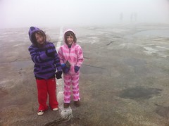
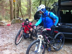
Clark and Suzy were on board, and I met them at their place around 10. They have a herd of dogs.

 The Neal Dogs

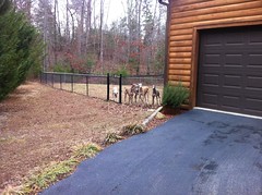
I thought they were deer at first.

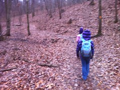
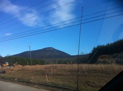
Our destination: Gumlog Mountain. I've seen it on the map since way back when I was first trying to figure out the Trans North Georgia route and always wanted to go check it out. It's just a bunch of forest roads, but I dig long forest road rides, and it looked pretty long. Also, it had a chance of still having snow. I missed all the snow last week and darn it, I wanted snow.

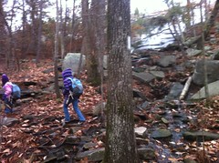
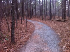
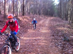
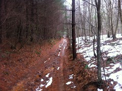
It took a couple of tries, but we found FS100, parked and started climbing. The road was a little soft, like 2-miles-of-effort-to-go-a-mile-soft, and it was steep for the first mile, and there was no snow. Not the best start, but pretty soon it got better.

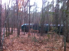
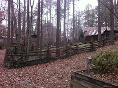
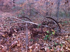
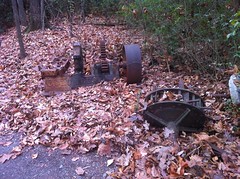
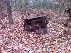
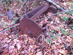
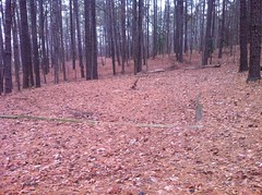
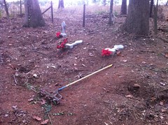
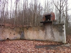
To the left, we noticed some ruins, just off the road, with a little trail leading right to them. Fairly modern ruins, as it were.

 Ruins

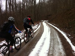
Eventually there was snow, but it wasn't that inch and a half of hard pack with a frosty/grippy-surface awesomeness that I'd hoped for. It was more like riding through a Slush Puppy.

 Climbing FS100

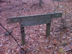
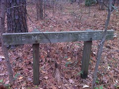
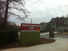
Up the road a bit, we saw this sign.

 Cerulean Warbler Sign

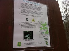
Apparently the Forest Service is trying to bring back the Cerulean Warbler. Henceforth, every bird I saw, was, at first glance, a Cerulean Warbler. I did legitimately see a small, Warbler-sized, blue bird, but it wasn't a Cerulean Warbler. We did see a really big, burly hawk that I thought was an eagle until we got a really good look at it. It's call wasn't exactly hawk-like, or at least not like the calls of the hawks around the metro ATL.

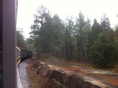
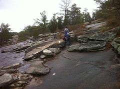
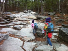
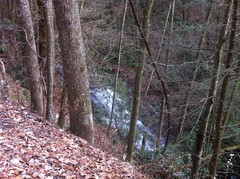
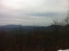
With the trees stripped of their leaves, there were plenty of good views. Ivylog valley:

 Overlook

I was digging it. The climbing wasn't so bad, and mostly we climbed, but every now and then we'd hit a little downhill, and the Slush Puppy created a rolling shower, from below.

At Ivglog Gap, it was decision time. My rough plan was to do a lasso; out on FS100, then either continue around and climb back up through the valley and backtrack on FS100, or alternatively, descend into the valley and loop back around to the north. One look down FS852 and it was obvious that climbing it would be better on a drier day.

 FS852

There were fresh tracks on the road. Somebody had been out wheelin' on it, maybe yesterday.

And so began our descent, and the real adventure.

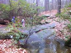
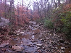
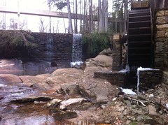
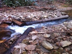
First we found a cool little waterfall.

 Ivylog Creek Falls

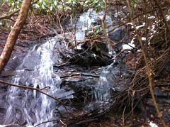
And each of us ended up dunking our feet, though Clark tried really hard not to here.

 Big Step

Check out that skill. Most people wouldn't have been able to avoid stepping into the water, or at least, when taking off their right foot, would have been unable to avoid spinning back and dunking their left. Skill. Unfortunately, there's no good way to recover from that stretch. It's bad enough to dunk your foot by accident. It really sucks when you have to decide to do it, especially after such an impressive effort.

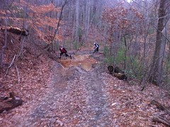
About halfway down, we crossed a little creek with a bit more of a hole in it than any of us expected. I managed to skirt it. Clark wasn't so lucky.

 Clark's Crushed Face

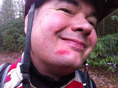
His endo would have been AFV-worthy if I'd been filming. His whole face and torso went into the water and his bars and stem crushed into a rock and even deposited some material on it. The mark on his face was really just a scratch, but it looked awesome. He cut his hand too, but that's what you get when you're not wearing any gloves, so wear your gloves, kids.

Earlier, when I called FS852 a road, I used the term "road" very liberally. At the top, it was heavily braided, with multiple former routes littered to the left and right. The current route was like a narrow Tibbs. Honestly, having some idea of the standards the USFS has for roads, I can't believe it's still open. It's a mess, it's right next to the creek, and it crosses it or its feeders half a dozen times, much like the now-closed-for-the-same-reasons Anderson Creek Trail. But still, it's in the USFS GIS data, there was an open pipe-gate at the top, there were no Kelly Humps and it clearly gets vehicular traffic. We rode it. "Blue on Black"

At the bottom, we were very confused. The details are infinitely complex, but suffice it to say, we tried really, really hard not to, but we ended up walking out on a private drive. There was only one sign, in the opposite direction from the direction we went, the fence lines are confusing, there are old and new fences that don't tie together, a timber sale added to the confusion, the western border of the National Forest there is unmarked, or at least we couldn't find it, USGS maps don't indicate ownership except for NF property, and so on. We tried hard, really hard. In hindsight, it's apparent that Ivylog Gap Road (a county road) ends at private property, but the road continues on that property and eventually becomes FS852. There's private property on both sides at the pavement, but the property to the south alternates between private and NF land. It's not unusual for a county road to run up a valley, bordered by farms and then become an FS road - Darnell Creek, Chestnut Mountain and Old Bucktown come to mind, but I'm sure there are a dozen in Georgia alone. At the time, I couldn't imagine the private drive wasn't a county road. I've never seen a county road become private, become pretty unmaintained, and only THEN become an open, inventoried forest road. I wouldn't have guessed that configuration existed before today.

Needless to say, the land owner was highly dissatisfied, got our attention, and rolled over in his truck, strapped with an AR-15. He started out with some posturing, but it was soon clear that he just felt violated, and maybe a little impotent about it. Like somebody who's house was just broken into, for the third time. Apparently folks regularly drive down the road and exit across his pastures and through his fences, with impunity. Since we were actually hanging around to talk, he seemed torn between kind of wanting to understand and kind of wanting to seize the opportunity to punish somebody, anybody. It was all over the place. He threatened us: "Oh, you won't see me but one more time in your lives", gesturing to his rifle, then later seemed to understand we'd tried to do the right thing and made an honest mistake: "Well, I suppose I've made a few of those in my life too", but then later still tried to call the Sheriff's office, or call somebody at least. Eventually, it occurred to me that we were actually no longer on his property, his threats were idle, and we weren't really obligated to hang around. We all felt bad about the situation though, and it seemed right to stay and talk it out. All in all, it went about as well as it could have. I hate that it happened though. I hate how I made him feel. I try to be a good steward, a good ambassador, and a generally good guy. Every now and then I fail pretty badly.

I guess the lessons are:
* Don't expect signage.
* Road configurations like this apparently do exist.
* Adapt accordingly.

Maybe that third one isn't exactly a lesson, just something to do.

So that's what I learned today. What will I learn tomorrow? What will it cost? What will it cost someone else?

With the day waning, we bailed on the lasso and took some paved roads back around to the truck. An elderly lady walking out to get her mail smiled and waved to us, so did a guy who passed us in his truck. Hey, somebody in the area doesn't hate us. Yay.

Nineteen-ish miles. Somehow it left me with a headache so bad that I had to take some Advil and a nap to kill it.

Maybe not the best way to round out 2010, but conflict aside, it was a good time, with good friends.

Happy New Year!

Sunday, December 19, 2010

Douglasville

Today I met my bro at his place in Douglasville for a couple of hours on the road. I'd bought 4 packs of Clif Blocks last week, but for whatever reason, I couldn't find them. I'm starting to think I left them on the counter at the shop. My brother's recommendation: "you don't need blocks, do the zero." The zero, apparently, being a 3 to 4 hour ride after consuming zero calories beforehand. I do the zero between my house and the Dutch Monkey donut shop when riding to work sometimes, and I'm no stranger to consuming fewer calories than I need, but an intentional zero didn't sound fun. Fortunately I'd had some Waffle House earlier, so no absolute zero for me.

I swear the hills around my brother's house are the steepest in the metro area. We were both grannied out and crawling on more than one, and that was just the first 10 miles. Part of that was winter weight gain, part just having ridden low intensity rides lately, part cold weather and part just being lazy. It was rough, whatever it was. I hoped I'd warm up or something.

We met Jake and Craig at Publix. Everybody was coincidentally wearing matching, flaming red BOR winter kits from way back. And me without my camera. The one time I forgot my phone.

I don't know if I was warmed up or something, but the rest of the ride was really good. Infinite rollers. You're never not climbing in Douglasville except when you're descending. I realize that sounds ridiculous. We did like a 30 mile loop or something, dropped Jake and Craig back off at Publix and rolled back to the house.

The zero was kicking in as we got close to John's crib. It's one long climb for the last mile and a half or so and both of us had those "hey man, you better cut this right out" legs. Fortunately we got back before any actual cramping occurred.

Awesome ride. I love the roads out there. We're going to have to do a few more of those this winter.

Stone Mountain

Last weekend I tortured the kids at Stone Mountain. This weekend I figured I needed to make up for that. Isabel had said she wanted to ride the gondola and the train, so we went back and did just that.

The gondola:

 Gondola

It was really foggy, but we could still see the mountain pretty well. The ride was shorter than we expected, but the lady driving the gondola was entertaining.

We walked around on top for a few minutes.

 Top of Stone Mountain in the Fog

It was cold and windy, but not as cold and windy as last weekend. Still, it was nice to know we could just walk back inside and take a ride back down. In the building at the top, they have these placards talking about the wildlife in the area. Apparently there are little shrimp that live in the pools of water up on top of the mountain that you can see in the summer. Wild! I'm going to have to go back to see that next year.

Next, we rode the scenic railway.

 Scenic Railway

It was neat to ride but not really all that scenic. It passed by a bunch of old granite quarries, and an old railway station, and there were old train cars parked here and there. I guess, in antiquity, the train was used to transport granite blocks from the quarries out into the world.

Finally, we hiked around the Nature Garden Trail.

 Girls at Shoal on Nature Garden Trail

I bet you were thinking "Yeah, I'm not sure riding trains and gondolas really counts as outdoor activities." Well we did go walking in the woods. The trail was short though and Isabel's feet didn't even have time to get cold.

We found a cool hollow tree too.

 Me in Hollow Tree

Also the had this little interpretive loop and I one of the signs showed this little purple berry thing that I always forget the name of. Beautyberry. Now I won't forget. Or if I do, then I can look back here. Man, that's something that's absent from the internet. With all this knowledge at our fingertips, still, if you know what something looks like, but don't know what it is, there's no easy way to find out. No way to google that up. Same with music. What song is that? It goes da-dun-da-da. If somebody can come up with an intuitive way to do either of those things, that would be great.

We followed up our little adventure with some Doc Chey's, of course, and Sophie ate swan chicken.

 Swan Chicken

Sunday, December 12, 2010

Stone Mountain

Today was family adventure day. Me and the girls had plans until it stormed all night and froze this morning. There were snow flurries when we left the house. We were winging it. Hasty plans don't always work out though, it's a lot like forcing a ride, but sometimes that's the best you can do, and we did, at whatever peril.

Breakfast/lunch was good. We ate downtown at the Highland Bakery. Comfort food. Yum.

 Highland Bakery

Our new plan involved Stone Mountain. With sketchy weather, it should be pretty interesting, and there are some trails there that we haven't explored yet too. The attractions were all shutting down at 5, but we could still climb all over the mountain until midnight if we wanted to.

We started out on the southern Connecting Trail.

 The Girls on the Connecting Trail

Less than 10 minutes later I got a call from my father-in-law. The Saints game was about to start. I called Kathryn to get her to record it, but as usual, it wasn't on the air in the ATL.

The Connecting Trail led to the Nature Garden Trail and eventually to the Cherokee Trail.

 Stream Crossing

Sophie was having a great time. Iz would have been having a great time if her toes weren't freezing. She had a lot of trouble with that last year. Smartwool socks helped, but we never really figured it out before it got warm again. The rest of us would be fine, but she'd still be cold. It takes her longer to thaw out too. Do we just need to insulate her feet more, or is the rest of her getting colder too and her body's cutting off the blood supply to her toes? Are her shoes too tight? Does she have poor circulation? We've got all winter to figure it out, but in the mean time, she's pretty miserable. I loosened one of her shoes to see if that would help.

The train came by.

 Train

We're going to ride it next time. Hopefully we can ride the gondola too.

Eventually we started climbing Stone Mountain proper.

 The Girls on the Cherokee Trail

Granite seems to be either the grippiest or most slippery substance in existence, depending on how wet it is. Today's wetness was sometimes ice. We were super-careful.

Iz's toes were still killing her. I took a quarter of the map they'd given me when we drove in, wrapped it around the toes on her left foot and we gave that a try.

Sophie's toes had been fine all day. Her shoes were "wilting" though. I love her vocabulary.

The Cherokee Trail led to the Hike-Up trail, and we hiked up, past the Gum Poles...

 The Girls at the Gum Pole

up and up and up.

 The Girls on the Hike-Up Trail

The map-wrap appeared to help a little, so we stopped at the halfway house and I did the same with her other foot.

The trickles of water running down the rock now had a thin layer of ice on top. The puddles were frozen solid.

We kept climbing. Eventually there were no more trees to block the wind, and man it was whipping. Fortunately it was at our backs, kind of pushing us on, but it was really cold. At the very top, it was so strong, the girls felt like it was going to pick them up and throw them over the side.

 Sophie at the Top

They were honestly scared of that exact thing. Terrified of it. Almost paralyzed with fear. Now that I think about it, they'd never been in really high wind before, and they weigh virtually nothing. It couldn't chuck them over the edge, but maybe it could have knocked them down.

We worked our way over to the little building at the top, huddled down behind a pillar, barely out of the wind, and assessed our situation. It was intensely cold, intensely windy, starting to snow and the girls were terrified, but there was nothing to do but walk back down. Iz's toes weren't hurting as bad though, the paper trick was working, and I was confident they could make it, even if they weren't. 1 2 3 Go.

I grabbed their hands and towed them down to the treeline. There's one really steep spot where they put a railing up and it was extra slippery there. None of us could feel our fingers or toes, we just had to wrap our arms around and work our way down, inch by inch. There was a couple ahead of us that kept looking back and probably called Child Protective Services on me when they got back to their car.

When we got to the treeline, we took a break. Out of the wind, it actually felt warm. Iz lied down on the pine needles for a minute. I kept an eye on her though. I've heard of people getting really hypothermic and wanting to lie down and sleep. I didn't think we were anywhere close to that cold though. It worked out. She was like a new kid when she got up. Like she'd left all the stress lying there and just stood up and walked away from it. I've never seen a transformation like that. It was weird. It made me worried that there was actually something wrong with her, so I kept talking to her after that until I was sure she was fine for real.

Sophie's toes were thawing out and seriously killing her. She was crying and kind of even screaming a little. Finally I had to tell her something like "Dude, you've got to use more self-control. If you keep that up, somebody's going to hear you, and think that I'm hurting you and think you need help. That could be pretty awkward." Thinking about it though, I was, at least indirectly, responsible for her pain. She understood though and got it under control.

Five minutes later everybody was feeling fine. It was like a kid pulling a tooth; yeah, it hurts, but the fear is the worst part. When it's done, you realize it wasn't that bad.

That said, there's a fine line between building character and just torturing kids. I walked it today. As much as they learned about their limits, I learned even more. With all that we've done together, I forget they're still little. I need to remember that.

Nobody got broken though, and we had some good noodles at Doc Cheys. I've said it before: as much as I love the outdoors, being in the outdoors makes me really love civilization. An hour ago we were freezing and struggling and now there's a friendly guy handing me a bowl full of all kinds of different things all stir-fried together. Oh yeah!

Sophie made noodle-art.

 Sophies Noodle Face

And apparently her blood type is coffee.

 Sophies Fortune

What a day.

Burruss, Life, Wildwood and North Cooper Lake

Well, my mountain bike's busted again. I had it on top of my truck, whacked the front brake lever on a low-clearance pipe and blew out a seal in the piston. I'm a klutz.

For some reason, I had little-to-no interest in the running around in the mountains today. Maybe because I was up late last night. Maybe because I've been up there a lot lately. Who knows. The road bike wasn't looking too interesting either. It was too late in the day to fish. Eventually I settled on doing some recon. I've been looking for new places to ride with the kids and there are a few parks around town (Atlanta being town) that might fit the bill. Yeah, I'll check some of those out. I need to jog more anyway.

First up: A. L. Burruss Park. I have no distinct memory of how I found out about this place; either on the Sorba forum or maybe from one of the Pauding Sorba folks. As I drove up, judging from the number of dudes sitting alone in their cars, I was pretty sure what this park was all about. The strategically placed hole in the port-a-potty leant further credit to my suspicion. I stumbled onto this particular subculture while Googling for info on the Mount Tabor Park a while back, and now I see it everywhere.

There are 4 bike trails at the park, all pretty short. All pretty wide and clear...

 Red Trail

I'd jog until something hurt, recover and jog again. I ended up doing that all day. My left knee hurts a little right now, but not bad. I got devastating shin splints early on, but they eventually went away. Is this progress? I have no idea, but it was kind-of fun, so at least there's that.

I'd bet that the girls could easily ride the Green and Blue trails and probably the Main Trail. Iz could ride the Red Trail but with no gears, Sophie would be pushing a lot. The park was a little boring, scenery-wise. No obvious points of interest, at least along the trail, and I didn't see any wildlife. Still though, the trails looked fun.

On the Red Trail, I got a call from my buddy Brooke. She'd just finished up a ride. I could barely hear her though so we didn't talk long. Immediately upon hanging up though, I realized I'd lost my map. It had apparently worked it's way out of my pocket while I was running. Dammit. That always seems to happen when I'm running but it never happens when I'm walking. I guess it's that extra little bit of momentum or something. Fortunately the trails were really simple and well marked. I did need it for later, but I figured I'd find it on the way out.

There's a connector trail over to the Life University Wellness Center trails at the north end of the park. You can't ride bikes on those trails, but hey, what the heck, I'm here, might as well check it out. The trail paralleled Rottenwood Creek, but the creek looked kind of nasty and stagnant, and it was littered with old garbage. It was a different story on campus. The trail led around the sports complex and further up along the creek, which, at that point, was rocky, clear, shallow and flowing.

 Eagle Trail

 Rottenwood Creek

I explored those trails too. There's this cool 19th century village...

 19th Century Village

with a dam and a mill...

 Dam and Mill

and a ton of old equipment that people dumped in the woods way back...

 Old Wagon Parts

 Old Mill Parts

 Old Machinery

 More Old Mill Parts

 Old Saw

There's a fine line between unsightly garbage and precious artifact. I guess it has to do with how deteriorated it is, whether anything like it is still in use, or how different its construction is from that of a modern equivalent. I thought about that a lot today.

Here and there I saw what appeared to be little bits of evidence left behind from the cyclocross race they had a few weeks back; a bunch of parallel cross-tire tracks in a soft spot, the remnants of an arrow painted on the ground, a leaf-blown trail, a shred of marking tape. Ahh, cyclocross. I need to get a cross bike and do some of that. It's starting to look fun.

Eventually I found a trail with a bunch of exercise stations leading west, off of Life U property and over to Wildwood Park...

 Wildwood Park Sign

...which I explored thoroughly. There's a dirt/gravel road, turned jogging trail leading around the perimeter of the park with a few innocuous-looking trails leading into the interior. Those trails though, as it turned out, were quite the spiderweb. It took a long time to sort out. Apparently, there was, at one time, a totally different set of trails out there too. I kept seeing old signs...

 Trails End Loop and Homesteaders Trail Sign

 Trails End Loop and Old Jonesville Road Sign

 The Meeting Space Spur Sign 2

 The Meeting Place Spur Sign 1

Some of them were kind-of along existing trails, but others were off in the middle of nowhere and there was nothing even remotely discernible as a trail nearby. There was an old and busted ropes course with only part of one segment still intact. Near a pavillion, there was a rectangle on the ground, apparently marking the location of an old homestead.

 Old Homestead Site

I also found an old cemetery off of the jogging trail that somebody had just been out caring for.

 Wildwood Cemetery

The ground was sunken in over each grave. Shallow graves and collapsed coffins?

It looked like they'd used some of the Wildwood trails in the cross race too.

After spending way too much time exploring miles of trails that had nothing to do with why I was out there to begin with, I headed back. I eventually found the maps I'd dropped earlier, lying in the middle of the trail, not 100 yards from my truck. As in, I'd gotten out of my truck and only walked about 100 yards before losing it. Wee.

I confused one of the dude-cruisers too. I walked off the Main Trail, crossed into the lot, then took a little side trail back out to the Blue Trail. I guess he figured I wanted him to meet me out there because he waited a minute, then sort of cautiously strolled out, following me and kept glancing over at me. I guess he realized I wasn't into dudes, because he pretty quickly turned around and just sat back down in his car.

Next up: North Cooper Lake Park. It's only a few miles from my Dad's place and you could spin a quick lap through there if you're on the silver comet, on a mountain bike... for some reason. Again, I have no distinct memory of how I found out about the trail, but apparently I put a placeholder for it in my trails site, and it's been there ever since, waiting patiently for me to explore it.

 North Cooper Lake Park Sign

I'm guessing this park is a work-in progress. The parking lot is large, and there is plenty of land for a playground and ball fields, though none are currently present.

The bike trail is less than a mile long, but surprisingly hilly. And there are at least two bridges.

 North Cooper Lake Park Bike Trail

Probably a bit too challenging for the girls right now.

There is one really cool thing there though... The Smyrna Community Garden. If you don't grow in your backyard, you can grow here, I guess.

 Smyrna Community Garden

Some guys were out there cutting wood and building something. I figure there's a 50/50 chance that they thought I was out looking for manly love.

When I got home, I Googled "Wildwood Park Marietta" to see if there's a site for it, possibly describing some of its history, and wouldn't you know it, 5 links down the page: that park is a popular dude-cruising zone too. So, now I have this nagging curiosity... How prolific is this? Where-all is it done? Are there dudes chilling at the Yellow River parking lot right now? How many times has it been going on around me and I just didn't notice? So many questions.

Man, I wonder if there's ever been some dude with pull in the local legislature that managed to get a park built with the specific intent of creating a local cruising zone. And like most of the people involved are oblivious and they're all thinking what a great thing this guy is doing, you know, for the community, but then there's that one dude on the planning commission that's down and the two of them are always exchanging sly smiles. Ha! Oh, man I'd have to give that hypothetical dude a high-five for pulling something like that off!

You know I'm not going to be able to help but scan the cars in every parking lot I drive into now too, right? If I see a guy sitting alone in his car, my brain's just going to automatically begin calculating the % chance he's trolling. So I have that to look forward to. Awesome.

Keep in mind though, while it's not my thing, I'm not judging anyone here. People are people, they do what they do. It is shocking though, how every now and then I stumble onto a subculture of some kind and it changes my world view, sometimes by a good bit. I wonder what the next one will be.

Sunday, December 5, 2010

Upper Chattahoochee

Friday, I drove to Baton Rouge for my Aunt Cindy's funeral service. For being such a solemn occasion, thinking back on it now, I only have good memories. I hope that's how it is when I go. I hope it brings people together and they leave with good memories. Saturday afternoon I drove back. In 36 hours I'd driven 18. Short miles for a trucker maybe, but I'm not hard like that and today I slept in 'til almost noon. It's funny, when your kids are old enough, they'd rather not to wake you up.

When I did get up, I headed up to Helen for some bikering.

 Yonah

I promised Clark next time I rode up there, I'd give him more than an hour's notice. I really meant to give him more than two hours notice too, but failing there, two hours was still enough time for him and Suzy to throw some gear together and meet me a the No-Camping-Here Campground.

 Clark and Suzy Getting Ready

I have a knack for taking photos that don't include the faces of anyone in the photo.

It was a little cold; just above freezing at the car. I tried riding with my REI jacket as a wind shell. It works pretty well on foot, maybe it would be good on the bike too.

We climbed Martin Branch, which I've never climbed before. It's not easy.

 Clark and Suzy Climbing

Another great photo. That's real talent.

Earlier, when I put my gloves on, I noticed the right one was damp, like maybe one of my bottles had leaked on it or something, but nothing else was wet. It was a mystery. About 10 minutes later I realized it was wet because I'd been wiping and blowing my runny nose last Thursday and hadn't washed them since then. That's just nasty.

At FS44 we hung a left and headed down. I say down, but we kept hitting little climbs. I've ridden the other way a dozen times and I don't remember any downhills.

In winter you can see waterfalls that you can only hear in the summer.

 Waterfall

Or maybe just the direction we were going made them easier to notice, or maybe a combination. Either way: waterfalls.

Somewhere around there, it started flurrying on us and pretty much didn't stop until way later when we were lower down.

We climbed 44E though the campground and on up to what I guess is Crain Field. At the back of the field, there were some interesting, new-looking constructions in the creek to create artificial trout pools. Suddenly, I can't remember what those are called.

 Trout Pool Thing

Did I say creek? Actually, I think that's the Chattahoochee River itself, just way up near the top. Look at that, it's small enough there to channel between a couple of logs.

Next up, Old FS44D, but only after more cold descending. Other than the hood inflating like a tiny parachute, the REI jacket was really getting the job done. Really, only my toes and face were cold, and I didn't care about the parachute; not racing today.

44D is also called Chattahoochee River Camp Road. We didn't find a camp, but we found a food plot and the old roadbed leading out of it was pretty overgrown. There was a clear trail through it, but the road formed the wilderness boundary and it bent back on itself there. It might not be in the wilderness, but we couldn't tell and it didn't look that fun to ride. Back down.

And so ended the exploring. The rest was just getting back to the car on FS44. It was officially dark. We'd had our lights on for a half hour. The snow flurries, lit up artificially, reminded me of walking around at night in New York City. At some point during all that my front brake had all but stopped working. I had trouble with it last Thursday. This morning I bled it, but now it apparently needed to be bled again. There was nothing leaking anywhere. My guess is that I've managed to somehow break another lever, which I seem to do from time-to-time. I have no idea how I did it this time. This would be like the 6th time though. Temperature wise, the ride back wasn't too bad. I do need some new shoe covers though, big time.

Yay, Upper Chattahoochee! We followed up a good ride with some good food at the Nacoochee Tavern, where we all got the secondary shivers. I had a meatball sandwich which was really good, but I think I like the chicken parm a little better.

Thanks for a great time guys. I promise one of these days I'll give you more than 2 hours notice.