Friday, June 23, 2017

More Bartow County

I got all my work done around 4:30 today and really felt like getting out of the house. But, I apparently forgot to wash my bike clothes after my last ride, and also it looked like it might rain. So, instead of going for a ride, it seemed like a good day to try to locate some more side-of-the-road things around Bartow County.

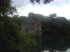
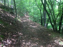
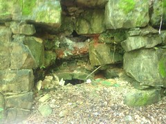
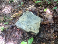
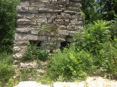
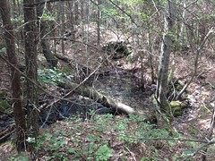
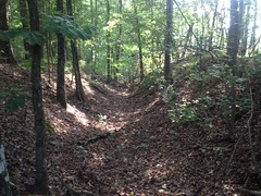
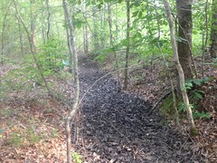
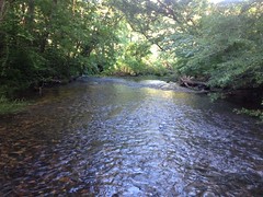
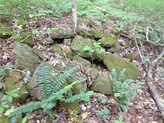
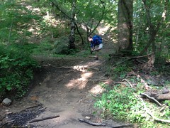
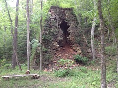
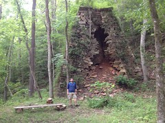
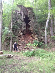
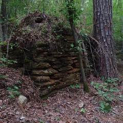
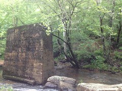
First was the Pumpkinvine Kiln. I'd made a half-hearted attempt to find this last time I was out, but not wanting it to turn into another Pool Furnace chase, I did a bunch of research a few days ago... I first saw the kiln, and lots of other cool stuff, on B&E Roberts' very excellent website, where he alleges that it lies on lot 1038. Where the heck is that? Well, the Etowah Valley Historical Society has an online map with lot numbers! They also have a photo of it with a caption referring to it as the Bevel Ridge Furnace. Lot 1038 is on Bevel Ridge Road, at the point where it comes close to Pumpkinvine Creek. That really narrowed it down.

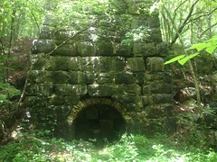
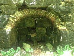
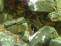
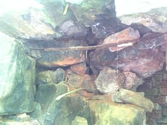
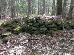
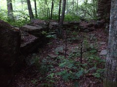
And, yep, it was right there where it ought to be, and perfectly visible from the road, in fact.
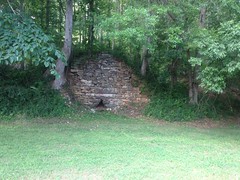
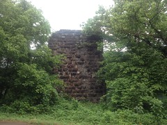
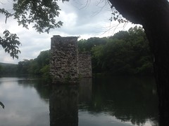
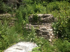
Pumpkinvine Kiln from Road

A little closer.

Pumpkinvine Kiln

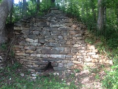
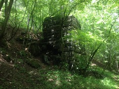
And, the general area around it...

Area Around Pumpkinvine Kiln

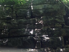
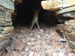
I considered climbing up the backslope to get a shot of the chimney, and if it's really a lime kiln then there ought to be a quarry up there somewhere, but someone's driveway runs immediately above the kiln, and it's really not clear where the property line is. Plus some dogs went pretty crazy as soon as they saw me, and who knows what they think the edge of their yard is.

Good enough.

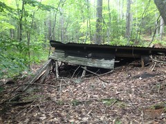
Next up, the Blue Ridge Mining Company's Manganese Plant.

Roberts has photos of it too, but he provides no location. He does provide a reference though, which is available online. Pages 57-58 describe the location, and the same old photo Roberts posted is between pages 80 and 81. Score! Lot 473, "a few rods from the Etowah River", 2 and a half miles east of Cartersville. My historical topo maps show a railroad running right through there, and a black rectangle (usually indicating a mill or factory) right there.

Ha! I'd actually driven right by it last time I was out. If it had been winter, I doubt I could have missed it.

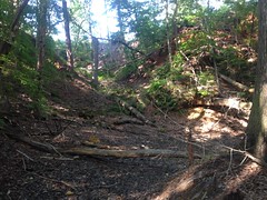
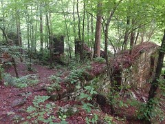
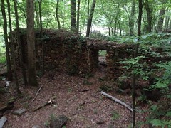
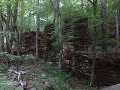
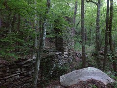
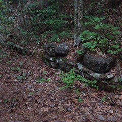
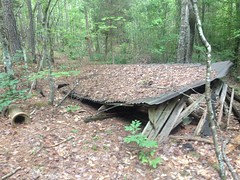
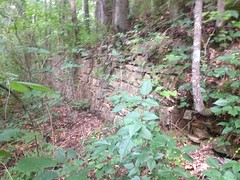
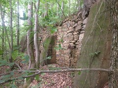
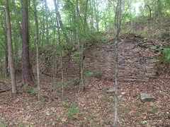
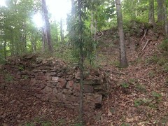
The plant was massive. The hillside was terraced to support it, with 5 levels of retaining walls.

Level 1.

Manganese Plant - Level 1

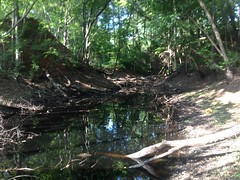
Level 2, with some impressive concrete piers.

Manganese Plant Level 2

Level 3.

Manganese Plant - Level 3

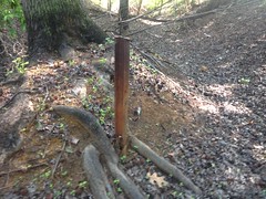
Mounts for machinery lay at the west end of the level 3 wall.

Manganese Plant - Machinery Mounts

And a pipe was sticking out of the ground there too.

Manganese Plant - Pipe

Levels 4 and 5.

Manganese Plant - Levels 4 and 5

Here's the photo from the book, hosted by Roberts:

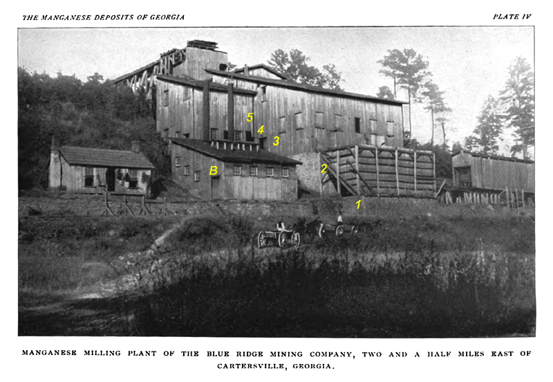
It looks like ore was loaded from the ramp at the top of the hill, processed as it moved down through the main building, dumped into the slanted bin sitting between levels 1 and 2, where it could be loaded into a railcar sitting on that trestle to the right with the covered-bridge-looking thing on it. The main rail may pass directly in front of the plant, where the road is today. It's not visible in the photo, but it may be obscured because the photo was taken below the level of the rail.

The building to the left, with the smokestacks is probably the powerhouse. Those machinery mounts would have been located between it and the main building.

The building to the left of that may be the office, or the residence of the big boss. Who knows?

I should have studied the photo better before going out there. I didn't even think to look for ruins of either of those 2 buildings.

The rock wall that runs along the entire front of everything is completely gone now.

I-75 lies immediately to the east. You could see it in the photo, if it had existed back then. There's a house in the location that the photo would have been taken from too. Across the road, there's a huge, overgrown hill, that's also not in this photo. I guess it was built-up in the intervening years.

All right, that was fun!

Next, I tried to find the Curtin Furnace.

There were at least 11 iron furnaces in and around the area in the mid 1800's:

  • Lewis'/Bear Mountain Furnace on Stamp Creek, in Pinelog.
  • Union/Diamond/Ford/Withers/Fire Eater Furnace, also on Stamp Creek, also in Pinelog.
  • New Stack Furnace, on Guthrie Creek, also in Pinelog.
  • Pool's/Lewis' Furnace, also on Stamp Creek, also in Pinelog.
  • Etowah (Creek) Furnace, also on Stamp Creek, but either underwater in Lake Allatoona, or on the Wilderness Camp Marina's property.
  • Allatoona Furnace, on Allatoona Creek, now underwater in Lake Allatoona, near the bridge to Red Top Mountain State Park.
  • Cooper's/Etowah (River) Furnace, on the Etowah, in the Cooper's Furnace Day Use Area.
  • Bartow Furnace, near where Bartow Station was, on the Western and Atlantic Railroad (which I think is CSX now).
  • Cartersville/Curtin Furnace, on Pettit Creek, near where Jones Mill Road crosses.
  • Rogers' Furnace, on Nancy Creek, where Rogers' Station used to be on the old Western and Atlantic.
  • Donaldson's Furnace, on Shoal Creek, in Cherokee County.

There were also various bloomeries, but I'm not counting those.

I had good directions to Cartersville/Curtin, but other sources say it no longer exists.

I figured I'd look anyway, maybe something still exists.

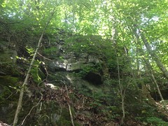
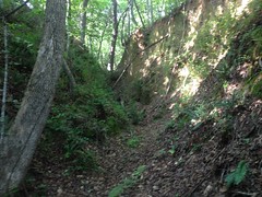
Unfortunately, the area was wooded, and the woods were fenced and gated.

If there's anything there, it's not generally accessible to the public.

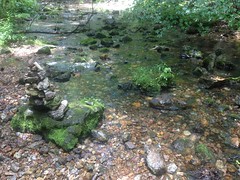
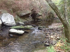
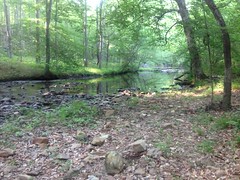
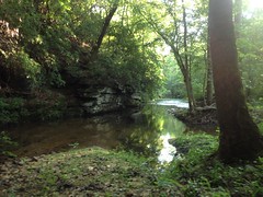
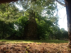
Next, I tried to find Rogers' Furnace.

I had a good idea where it would be from here and an even better idea from here. But this furnace too was alleged to no longer exist.

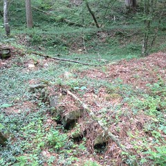
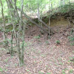
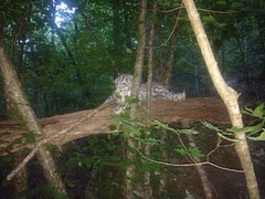
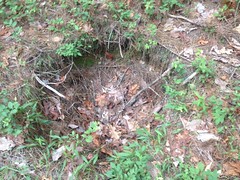
I found the spot easily, or at least I think I did, but there wasn't much there.

There was a hill, west of the creek, that seemed likely the hill that the furnace was built into. More might lie on the opposite side, but I couldn't see anything from the road. No furnace, no kilns, no cotton gins, no grist mill, no lumber mill, no railroad station...

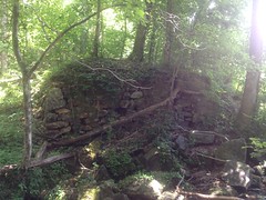
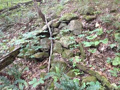
All that remained of Rogers' empire, or at least all that I could see, was this lonely chimney standing under a tree in a field, between the railroad and creek.

Rogers Farm Chimney

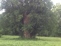
Made me kind-of sad, actually.

The field was also fenced and gated, so I had to zoom in quite a bit to get that photo. Blah.

Oh well.

Next I tried to find the remains of (or ascertain if there even were remains of) the Clifford Lime and Stone Company, as described in ​A Report on Limestones and Cement Materials of North Georgia, PDF page 322, site 7B on the map on page 161.

I was way less optimistic about this one. The creeks shown on the map bear little resemblance to reality. "3 miles northwest of Kingston on a spur track of the Western and Atlantic Railroad" only kind-of helps, as the spur is long gone. EVH's Map shows the community of Clifford further north than I thought it would be. Also, I couldn't find anything even vaguely indicating that any trace of it remains.

Yeah, it was a long-shot.

Still, I drove up and surveyed the area. There was plenty of woods to hide any number of old kilns in, and it's the wrong time of year to see much through the woods. Long-shot indeed. Maybe next winter.

It was raining pretty furiously by then too, and getting kind-of dark.

Time to pack it in.

All-in-all, I was pretty satisfied. 2.5 out of 5 isn't bad, especially when I was just driving around on a rainy day.

I'll take it!

Monday, June 19, 2017

Bartow County

This past Saturday I had the option of riding in Ellijay with Baldwin, or doing trail work at the new Yonah Preserve with Clark, but I ended up doing neither! Late Thursday afternoon, the power went off at one of my client's sites, and I spent all day Friday getting things straightened out again. Then, Friday evening, a UPS failed and I spent Saturday morning straightening that out. Dangit! No ride. No trail work. I took the opportunity to catch up on sleep though and woke Sunday morning refreshed and ready to explore my world.

Saturday morning was Father's Day, but my family is out of town, so we're going to celebrate it when they get back. I had the whole day to myself.

All that exploring I've been doing at Pinelog has gotten me interested in the mineral history of Bartow County. Seems they did a great deal of mining around those parts, way back, and still do. Iron, Manganese, Limestone, and Ochre seem to be, or have been, the principal industries, and since they were for so long, relics still stand from the bygone times. I've found some of them, but many more remain.

Seemed like a good day to go searching for some of them.

First up, the old Etowah Train Bridge. You can see it from Hwy 41. I'd see old photos of it, back when it was in use, and it was on the way to other stuff, so I figured I'd check it out.

Old Etowah Train Bridge Piers 1 Old Etowah Train Bridge Piers 2 Old Etowah Trian Bridge Piers 3

The bridge was built in the 1840's, burned and was rebuilt a couple of times during the Civil War, and was finally decomissioned in 1954 and replaced with the new bridge.

Modern Etowah Train Bridge

All that remains of the old bridge are the piers and some small amount of who-knows-what on top of them. I guess the iron could be scrapped, but there was no profit in tearing down the piers. As such, I imagine they'll be around for a pretty long time.

Next up, the Akin Lime Kiln. I'd seen photos of it, and it looked pretty cool. Also, the description of its location was pretty good: about halfway between Cassville and Kingston, on Limekiln Branch, near the old Cave Station.

Cassville and Kingston are easy to find. Modern topo maps show Limekiln Branch. Historical topo maps show "Cave" as a stop on the railroad, right at the branch. It ought to be right there.

Yep. The side of the road was slightly worn, and there was a bit of a hole in the woods there, leading to a nice old roadbed.

Old Akin Lime Kiln Road

And just up the road, the kiln emerged from the backslope.

Akin Lime Kiln (From South) Akin Lime Kiln (From East) Akin Lime Kiln (From North)

My understanding of lime kilns and their operation is somewhat limited. But, as I understand it, there was basically a refractory brick chimney in the middle, surrounded by a stone structure for support, with dirt packed between them for insulation. Brick-lined arches provided access to the bottom of the chimney. The chimney was stacked loosely with alternating layers of wood and lump limestone. A fire would be built at the bottom and would burn its way up through the stack. Air would be drawn in through the arches. Lime would be converted to quicklime. Eventually the fire would go out, the furnace would cool, and the good stuff could be raked out through the arches.

Arches (or what's left of them):

Akin Lime Kiln Front Arch Detail Akin Lime Kiln Right Arch Detail Akin Lime Kiln Left Arch Detail

Chimney:

Akin Lime Kiln Chimney

There were a lot of bricks in the exterior of the kiln. I wonder if they patched holes, or if they were just always there.

Akin Lime Kiln Exterior Brick Detail

There were also a bunch of metal straps sticking out here and there. Their purpose wasn't obvious at the time.

Akin Lime Kiln Metal Detail

The kiln was operated around 1912, I think. I imagine they must have used the quicklime to make cement and mortar, and maybe in agriculture. I'm not sure what else.

The old road kept going north, and there was plenty limestone lying about, as might be expected.

Limestone Lying About

The map shows the creek continuing way up the draw, but in real life, it disappears into a boulder field. It may flow at other times of the year, but Roger's Spring, slightly east of the field...

Rogers Spring

...appears to supply all of the water in the summer months. I wonder if the mountain is mostly limestone, shot full of underground passages, and the creek flows as much below ground as above it, just emerging conspicuously at the spring.

Uphill of the kiln there were 2 distinct quarries.

Akin Limestone Quarry

It seemed like there was one along the creek too, but I could be wrong. It might have been a natural formation.

On the way out, I noticed abutments for an old bridge.

Old Bridge Abutment

I guess the main road used to cross there instead of in its current location.

Not sure how I missed them on the way in.

All right!

Next up, the Howared Cement Kilns.

Again, the description of their location made them easy to find. They were located in Cement, Georgia, north of Kingston. The town is gone, but both old and modern topo maps both still show "Cement" as a place, and if you're looking, the kiln is hard to miss.

Howard Cement Kilns Howard Cement Kiln Right Side Detail

Unfortunately, the ruins mostly lie behind a gate, with big chunks of rock placed to prevent people from driving around it. There were no "keep out" or "no trespassing" signs, but still...

Cement kilns of that era operate much like lime kilns, just at a higher temperature. At the higher temperature, you get alite rather than quicklime, which is the main component of portland cement.

There are allegedly ruins of a cylindrical kiln to the left (north) of the main kiln, but I couldn't go over there to check it out without crossing the gate, and it was so overgrown that I couldn't make out anything distinctly.

To the right (south) of the kiln, on this side of the gate, there were footings of some kind.

Footing For Processing Building

One of them appeared to have a cylindrical, brick-lined hearth.

Processing Building Detail

There were allegedly up to 6 kilns running on the property, at some point. Maybe they lay in a line from north to south.

Old photos show various processing buildings to the south and in front of the kilns, but only the double and cylindrical kilns are visible in the photos. Any other kilns are obscured by the buildings.

The whole are is super, super overgrown. I couldn't make out much else with all of the brush.

One thing did strike me though... It's not clear how everything was powered. The nearest creek is across the road, and across the tracks. There's a small creek to the north, and the map shows a pond on it. Maybe water was piped over from there? Why wouldn't the kilns have just been built closer to it though? Maybe everything was powered by steam engine? I can't find any info about any of that.

Oh, also... I found something in the brush that I recognized, but don't remember what it is. What are these?

What Are These

At first I thought paw-paw, but they're too small for that.

???

Ok, that was it for the Howard Cement Kilns.

Next, I made a half-attempt at locating the Pumpkinvine Kiln. All I know is that it's located on Pumpkinvine Creek. That was easy enough to find, but it's very long, only accessible in a few spots, and the kiln could be anywhere. I did see one trail that looked promising, but it was apparently just a fishing trail.

Blah! Onward...

No trip to Bartow County would be complete without a trip to Pinelog, and my day ended with one of those. The details would read much like any other trip to the area, so I'll just get to the discoveries.

Pit mine on the ridge east of Alexander Hollow:

Pit Mine on Ridge East of Alexander Hollow

Looks like nothing. Again, a hole in the ground is difficult to photograph.

Flooded mine shaft just uphill from the pit mine, on the other side of the old road:

Flooded Mine Shaft on Ridge East of Alexander Hollow

I say shaft because the pit itself was much smaller than the waste piles surrounding it. It must, at least at one point, have been an actual shaft.

Some of the rock in the waste piles had been organized into low walls.

Rock Wall in Waste Pile

A long trench had been cut from the shaft to the road too.

Mylar ballon:

Mylar Balloon

I realized recently that I'd stopped mentioning seeing them. Rest assured, I have encountered at least one per hike or ride.

Eastern Hognose!

Eastern Hognose

At first I thought it was just a run-of-the-mill black rat snake, and I wasn't even going to take a photo, but it looked a little heavy bodied, so I stopped for a second and it had already started to flatten out.

I've read that they play dead if threatened, so I hoped that it would do that, but instead it got super mad, hissed, and acted like it was going to strike.

Eastern Hognose - Defensive

Ok, sorry buddy, I'll leave you alone...

Later I read that they try to scare you first, by flattening out, hissing, preparing to strike, and striking, but not actually biting during the strike, just head-butting you. Then, if that fails, they flip over and play dead, sometimes sticking their tongue out, and even emitting some stank from a stank gland in their cloaca. Nice! The hissing and strike-preparation was enough for me. Good job snake! Faked me out.

Conner Ore Bank:

Conner Cut - South Conner Cut - East 1 Conner Cut - West

One of the iron mines along the old Iron Belt Railroad.

It consists of 3 large pits that stay filled with water most of the year. One of them was mostly dry yesterday.

I presume that this is the Conner Ore Bank, as it sort-of matches the description of the location given here. I guess it was worked a bit more since that was written. I can't find any other reference to any other ore bank that it might be.

Someone hammered a light-gauge rail into the bottom of one of the pits.

Old Rail in East Conner Cut

It looks like it's almost rusted through at the base.

There was also a long trench cut south of the pits, leading to a nearby dry stream bed.

Conner Cut - Trench

It wasn't just an old roadbed, for sure. Its location and design suggested drainage. Maybe for an ore washer? Maybe water had to be pumped out of the pits regularly?

Historical topo maps show a pond across the road to the east, but I haven't explored that area yet. Maybe it will shed some light.

And that was it for Pinelog.

I wrapped up the day with some delicious Wendy's and headed home.

Ok, so that was my Father's Day. I explored my world and actually found stuff! I win!

There are still a dozen more things to be found though: Pumpkinvine Kiln, Donaldson Furnace, Cooper Furnace (actually I know where that is, you can see it from space), Etowah Furnace (which I think is submerged under Lake Allatoona), Etowah Manganese Mill, various mine cuts that I can kind-of see from the road, some old bridges, cemeteries... Not to mention everything else in the rest of north Georgia.

Enough to keep me occupied for a long time.

Saturday, June 17, 2017

Too Much Pinelog

Ok, so I've been to Pinelog at least 8 times since the last post. The first four trips I spent scouring Stamp Creek for Jones Mill and Pool Furnace. Legend holds that the two occupy the same property, and if I found one, then I ought to find the other nearby. My search was monumentally misguided though. Someone should literally erect a monument to how wrong I was about where I thought it was.

Of course, I didn't know that at the time, so for a while, I proceeded, with enthusiastic optimism, directly into oblivion.

Fortunately, Stamp Creek itself is very scenic.

Stamp Creek - Rocks Stamp Creek - Bend

So, at least there was that.

During the first trip, I searched every inch of the creek, from the paved road to the falls, or at least every inch of land not marked Posted, Keep Out. All I found were old roadbeds. All manner of them. This one was particularly interesting because it may have been a ditch rather than a road.

Lower Stamp Creek - Old Roadbed or Ditch

During the next trip, I started way south, at Hwy 20, and searched north until I hit private property. This involved a really long trek through really tall grass, in snake and tick season. Fortunately, I encountered neither.

The creek is a lot wider down there.

Stamp Creek in Allatoona WMA

Trying to cross, I slipped down the bank and kind-of cannonballed into it, so I guess it's good that it's deeper too.

Again, all I found were old roads. Despite modernish topo maps showing a ruin where the road crosses the creek, I found no such ruin. It may have been bridge pylons or something, long washed away. No mill though. No evidence of one. It was discouraging, because the map also shows that the road that I found leads up to another road, named Old Mill Road. How can Old Mill Road not lead to an old mill? I would eventually find out, but not for a while.

I did find an Ohio plate back in there, all shot up, in the middle of nowhere.

Ohio Plate

Didn't expect to find that.

During the next trip, I started at the Stamp Creek Road and explored south until I hit the WMA boundary.

Again, the natural beauty of the creek itself made the otherwise fruitless effort seem almost worthwhile.

Stamp Creek Below Stamp Creek Road

The fishing trails along the creek were braided, occasionally washed out, and generally difficult to follow. As before, I found various old roadbeds, all of which eventually led to private property, or back to the pavement.

I did find a bunch of what I like to call "organized rocks"...

Organized Rocks More Organized Rocks

...and I was momentarily optimistic, but the moment was fleeting. That's all there was.

For all my frustration and effort, nature rewarded me a bit on that trip.

Turtle:

Turtle

Yucca:

Yucca

Blackberries!

Blackberries

I ate so many of them.

So many.

And a wolf spider the size of my hand, carrying her babies on her back.

Wolf Spider With Babies

Just hanging out on the road there.

But no furnace, and no mill.

Before leaving, I looked at my map again. By process of elimination, there was only one place that it could be. It must be south of the paved road, in a tiny little corner of the WMA further south than I'd yet been, but north of Allatoona. I could see that there was a creek that I could follow down to that spot. There's an old gated road leading north of the pavement along that creek. Maybe it also led south, and I just didn't notice before.

On the drive over, to check it out, I drove right by a road named Old Jones Mill Road. Seriously?! How did I never see that before? Well, it's not named on any map, I'd only driven by it once, ever, and, I'd only ridden by it once, in total darkness. Plus, I'd never thought to look over that way before because a semi-modern map of the area and hunters talking about it on the GON forums, both put the mill well north of the paved road.

Ha! Maybe I could drive to it.

Alas, the road became a private drive almost immediately. There was a trail leading down that creek though. Hmmm...

During the NEXT trip, I brought Billy with me. I figured I wouldn't fail if I drug someone else along. The stakes were just too high.

We parked at the gate, descended the trail along the creek, discovered a crashed flying saucer...

Flying Saucer Crash

(in real-life it looks a lot more disk-like)

...and eventually discovered a maze of trails and old roadbeds which looked like they got plenty of foot, horse, and ATV traffic.

These took a while to sort out. They all looked promising, and we anticipated finding something quickly, but we mostly just found more and more trails and old roads.

There was this rift in the hillside along one of them though.

Possible Mine Cut

Which looked like it might be an old mine cut. And that same hillside had a few more of what may have been slumped-in cuts along it too. It was encouraging. We might finally be in the right place.

We also found a cool snake.

Snake

Billy does not like snakes, but he didn't seem to mind that one.

We'd crossed Flying Saucer Creek 3 times, explored all we could on that side of Stamp Creek, and finally had to cross Stamp Creek too.

Billy Crossing Stamp Creek

It was good that we did though.

Because, finally!

The Pool Furnace!

Pool Furnace

You can really see the chimney in this one.

Billy at the Pool Furnace Me at the Pool Furnace

Built in 1855, owned by B. G. Pool and John W. Lewis. This furnace is sometimes referred to as the Lewis Furnace, which is confusing because the actual Lewis Furnace is located way farther north, but also on Stamp Creek.

Ore was dumped in the top of the furnace. Air was blasted in through the tuyere arch on the left side by a set of bellows, powered by a waterwheel. Molten iron flowed out of the casting arch on the front side. Slag also flowed out of the casting arch, presumably to the right of the molten iron.

There were old slag heaps to the left of the furnace. Though they were not as extensive as I expected them to be.

It wasn't clear where the waterwheel and bellows were placed. No remnants of the race were visible in the creek. No remnants of the outflow box were discernible. We wondered if the wheel might have been placed in the semi-rock-armored hole directly next to the furnace, and may have had a long race leading to it from well upstream. It just wasn't clear.

I was facing the casting arch, explaining the operation of the furnace, and Billy was like: "Hey Dave, there's a door over here on this side..."

"Yeah, that's the tuyere arch..." (walking around to the side) "...that's where the bellows... Aaaah!

Pool Furnace Cheetah

Gave me a heart attack.

Oh, man, we laughed.

An old road wound its way up the hillside above the furnace, and I explored it a bit.

The cellar of the Big House was a little ways up hill.

Cellar Uphill of the Pool Furnace

There was a small mine cut above that.

Mine Cut Uphill of the Pool Furnace

And further up there were more small cuts and old eroded chutes. I didn't explore it very thoroughly though. We had a mill to find.

Goodness, it was difficult to find. It HAD to be ON an old road though. It just had to be. We followed every one we could find. The further upstream we got, the more narrow and inhospitable the terrain got. It just didn't look like a good spot for a structure of any kind. It was also getting dark. Finally, we crossed the creek again, and followed a rugged ATV trail, as a last ditch-effort. It led to a well travelled old road, notched into a steep hillside, and the mill ruins sat right below that road.

Woohoo!

Jones Mill - Standard Photo

The mill was built, post-Civil War, by R. H. Jones as a saw and woodworking mill to support his carriage, buggy, phaeton, and wagon business. Eventually furniture and caskets were also produced.

There is a large room at the northwest end of the structure...

Jones Mill - Large Room to Northwest

...and a smaller room at the southeast end, which I couldn't get a good photo of.

The back wall supports the road, and extends a bit southeast of the smaller room.

Front face:

Jones Mill - Front Face - Northwest Corner Jones Mill - Front Face - Southeast Corner

On the northwest end of the complex, a sluice and 3 large spikes mark the location of the mill wheel. Presumably that room housed the main machinery.

Jones Mill - Mill Race and Fasteners

Both rooms are raised above a curious box-shaped depression, 2-feet deep, and 4-feet wide, walled and floored with rock, that runs the length of the complex. It may have housed some set of shafts, belts, and pulleys below the floor.

Also, I suspect that the mill mas multi-story, the remaining ruins effectively having been the basement, and the main part of the mill having been a wooden structure above it.

The structure may have extended over and across the road too, as the remains of a few small walls line the backslope above the road, behind the larger room:

Jones Mill - Rock Pillar Above Road Jones Mill - Low Rock Wall Above Road

In addition to the woodworking mill, the complex was alleged to have eventually housed a grist mill and store. The grist mill may have been run by the same wheel and occupied the southeast end, in and above the smaller room. The store may have occupied an excavation above the road, above the rock wall supporting the road to the southeast of the smaller room. The excavation may have originally provided fill dirt for the road itself.

Of course, all of this is speculation. I cant find any reference to or photographs of the mill when it was in operation.

From the shape of the road to the northwest, it was clear that people usually came in from that direction. We followed that road a bit. It crossed the power line cut and eventually led to a deep pool with a rope swing. Oh hell yes, I was swinging! The rope was solid. The pool had good depth and was free of debris. The tree had plenty of leaves. Check, check, check. Swing!

As I hit the bottom of my arc, the branch the rope was tied to broke and I went flailing into the water, trying to get as far out into the pool as I could. Fortunately, the branch fell straight down, and missed me by several body lengths.

Ha! I guess I'll know to check the branch the rope is tied to a little better next time.

I can't explain why we have no video of this. It would have been great.

I hauled the rope, branch still attached, back up into the precipice. Sorry guys. Glad it was me though, and not you. Whoever you are.

Ohh, it was getting dark. Who knows how much further the road goes. We gave up and headed out, avoiding 2 creek crossings by betting that an overgrown road would take us over to one we'd been on earlier, which it did.

We also passed a snow leopard, perched in a nearby tree.

Snow Leapord

We'd walked right past it earlier. Makes me wonder how many bear, mountain lions, bobcats, and bigfoots I've walked right by in my life.

When we got out, it was as dark as it gets, but we'd finally done it! I was so happy. You can't imagine.

During the next 3 trips, I explored various extents of various old roads, discovered that "Old Mill Road" and "Old Jones Mill Road" were once the same road, and were once connected across the creek by a bridge...

Stamp Creek Bridge Piers

...only the piers of which remain.

(Side note: I'd might have known this before, had the ArcGIS USGS Historical Topo Map Explorer provided the Cartersville Area Special Mining maps from 1906 and 1941 when I was integrating that data into the Historical Topo layers on my trails site. But they are notably absent. The University of Alabama Map Collection has them though, and they graciously sent me full SID files, which I converted to GeoTiffs, georefereneced with QGIS, cut into tiles, and included them with the rest of the historical topo maps on my site. So, now I can browse them at my leisure. Ahh, el luxurio.)

There's also what appears to be an old mine shaft near the mill.

Mine Shaft Near Jones Mill

It's hard to take a picture of a hole in the ground though! The photo looks like nothing.

After exploring a while, and comparing my GPS data to various boundary maps and became very curious about the status of all that land out there. The Pinelog WMA boundary is well marked in some places and completely unmarked in others. The furnace appears to lie inside of the WMA. The mill appears to lie just outside of it. The Allatoona WMA is well marked. It's not clear who owns the bits between them though, or between sections of Pinelog, or whether they care if you're on their land. The roads and trails appear to be equally well traveled, across borders. Is it county land? The few posted signs I did find face the road, as if to tell people on the road to stay out of the woods to either side, but maybe the road itself is OK? I'm no fan of trespassing, but I also like clear indication as to whether I am or not. It all makes me a little nervous.

During several more rides and hikes later, I discovered the Boston-Brooke Schoolhouse at the end of Brooke Road.

Boston-Brooke Schoolhouse Boston-Brooke Schoolhouse Sign

...and an old collapsed structure of some kind on a spur of Rock Quarry Road.

Rock Quarry Road Area Ruins 1 Rock Quarry Road Area Ruins 2

...and an old well, I guess, also in the Rock Quarry Road area.

Rock Creek Road Area Old Well

Sadly, no actual Rock Quarry though. The hillsides are quite notably strewn with squared-off boulders, so maybe they just collected rock from the side of the road back in there. Perhaps the road never lead to a quarry, but rather WAS the quarry.

I also found myself, again, and again at this overlook on Grassy Meadow Road.

Grassy Gap Road Overlook

I'm not sure this gorgeous vista was intentional. I think it's just a byproduct of the recent logging below it. Either way though, I've stopped there many times to take in the big sky.

Big sky is rare in Georgia, and I always appreciate that I have such a good spot to see some.