Sunday, October 31, 2010

CMBAR

Ed and Nam had so much fun at PMBAR that they were compelled to create their own. So, they invited a bunch of us up to Mulberry Gap for some crazy-time in the Cohuttas.

I almost didn't make it. I'd taken my bike to the shop to get the fork swapped, but my headset was cracked and the lock-ring on my front hub was seized so badly that it broke when they tried to loosen it. I love Chris King parts, except for when I hate them. Luck was on my side though, and Friday morning, everything was fixed. Chris even came in to get it done after crashing on his cross bike that morning and busting up his shoulder. Thanks bro.

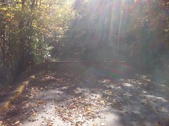
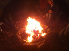
Friday night, I arrived to ghost stories and a warm campfire.

 Campfire

My ghost story - thinking my house in New Orleans was haunted, only to find out we had mice - wasn't as thrilling as the others.

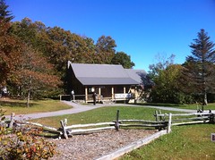
Me and the E stayed up for a while, waiting for the coals to die down, and then I hit the sack in the coziest cabin of all time. I had crazy, vivid dreams. In one, I had joined the army, and in the other, I was getting ready for the ride, but I'd left my clothes outside and they'd gotten snowed on and then covered with big black ants. Strange. Between the dreams, I woke up with hot feet. That's how you know it's cozy. Hot feet.

Ginny cooked up eggs and waffles for breakfast. I meant to eat strawberries too, but I got distracted and then when I remembered, they were long gone.

There's no cell service at MGap, but Kathryn had called the main number sometime the night before. Sophie had gotten sick with a stomach flu. I almost had to bail, but she called back a few minutes later and said she had it. You have no idea how averse Kathryn is to stomach ailments. She was really taking one for the team.

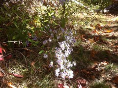
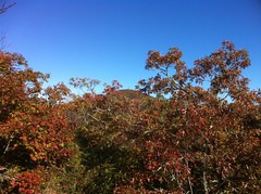
Walking back to my cabin, I noticed a cross in the sky.

 Cross

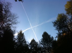
At an art show last week, a lady had taken a shot of one of these above a cemetery with a statue of a praying angel in the frame. "Praying for a Sign" I think it was called. I took it as a good omen.

I've been rocking a sleeveless jersey all year, but today I wanted arm warmers, and with every single other sleeve-having jersey I own stretched out and retired, I pulled out the Team Vortex jersey from the 24 at Rocky Hill back in 2003 or so. It has, maybe, 40 miles on it. The material it's made of is kind of thick, but not fleecy. I think I'm going to wear this jersey more this winter.

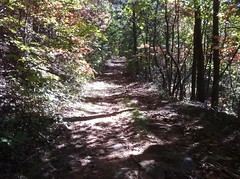
There were 10 or 12 folks there - a couple of husband and wife teams, and the rest of us were solo. Me, Marc Hirsch and Chris Hines were solo, but we decided to ride together. There were 4 mandatory checkpoints and 4 optionals. I grabbed a Mulberry Gap pamphlet which contained a map of the area and plotted our course. At the last minute, I realized I had to bleed my front brake. Street Hookin'. I got the brake fixed, but I misadjusted the lever and all day the shifter kept catching on it. Not a big deal though.

The start was lazy. You could leave whenever you wanted, you just had to take a photo of your start time.

 Meanpants - Start Time

Yes, that says Meanpants. Marc's nickname. His email address also includes meanpants, but apparently meanpants proper was already taken, so he had to add numbers on the end. There are other meanpants'es out there. Who'd have thought.

We powered up P3 to Hwy 52. I felt weak, but I chalked it up to time off the bike. My new fork felt great already. I need to dial it in a bit, but it was night and day. It's deer season, so I was wearing an orange vest, but it was like a radiator cover and I was running hot, hot, hot. We ran into a big group of hikers taking a break at one of the switchbacks. They cheered when I cleaned it. At Hwy 52 it was getting warm and we ditched the arm and leg warmers. I ditched the vest too.

Then I made another one of my famous navigation errors. I took a right. I was confident that the overlook was to the right. We rode all the way to the Fort Mountain Lodge before Marc was like "Are you sure it's not the other way?" We checked the map. Yes. It was the other way.

During that fiasco, I managed to drop my chain over the outside and got it wrapped around my pedal. One of the links got twisted, but not badly enough to notice at first. About every 3 times it would go through, the chain would kind of skip. I had a powerlink, but I figured I'd fix it when it broke. Instead, I ended up riding on it all day and it never broke, once again validating my bike's nickname: The Rolling Junk Show.

We finally found the overlook. It was actually within sight of the trail. If we'd just looked left, we'd have seen it.

 View from Cohutta Overlook

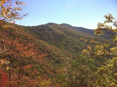
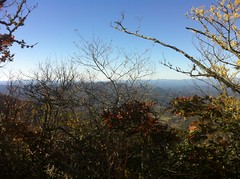
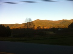
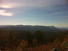
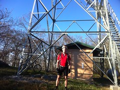
That's Grassy Mountain on the left. I'll be up there later. In fact, I'll cross that entire ridge, from right to left.

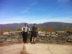
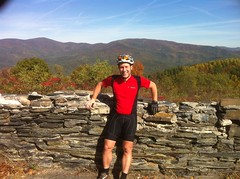
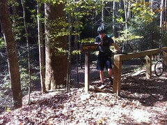
There was no punch card. To get credit for a checkpoint, you had to take a photo of yourself there, or get your buddy to take one of you.
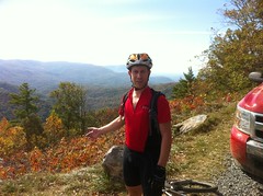
Chris and Marc.

 Chris and Marc at Cohutta Overlook

Me.

 Me at Cohutta Overlook

Chris was like "screw you guys and your wrong turns" and me and Hirsch were on our own. He stopped on the way down P3 to let some air out of his tires. I needed to do the same, but I kept forgetting to actually do it.

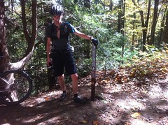
The next CP was at the top of the P2 singletrack. P2 is a lot less fun as a climb.

 Marc at P2 Sign

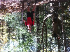
Marc took this photo upside down.

 Me at P2 Sign

While taking photos, a group of riders came by in the fun direction and I thought I recognized one of them. I did! It was Curt Reffner. I recognized him from his Facebook photo. He'd emailed me a few weeks back, inquiring about the Cohutta trails for a trip he was planning up there. What are the odds we'd run into each other? Awesome.

We took the roads around to Bear Creek, waved hi to some riders parked along Gates Chapel and started climbing. There were lots of hikers on the trail, some of them had extra-friendly dogs. One guy, a bit overweight, joked with us "If you boys keep that up, one day you'll look like me!" Ha ha ha. Over the past few years I've seen increasingly many hikers on Bear Creek and the Pinhoti's. "Et ca c'est bon." My read is that increasingly, as happened with the equestrian community, the hiking community is discovering that the rumor that "those trails are overrun by out-of-control bikers" is overstated, and that encountering riders doesn't utterly destroy the outdoor experience. On the other side, if there are any actual out-of-control bikers out there, encountering hikers should either drive them away or teach them some manners. Win-win, all around.

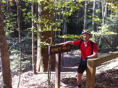
CP3 was the Gennett poplar, with it's 18 foot girth - the 2nd biggest tree in Georgia. I want to see the first biggest. I've seen some good candidates near Cochran's Falls.

 Marc at Gennett Poplar

 Me at Gennett Poplar

Near the top of Bear Creek I started to realize I hadn't brought enough food. I was kinda going on my 6-hour diet - 2 or 3 clif blocks and 3 or 4 enduralytes an hour. That's good for whipping around cross-country courses, but falls a bit short in the mountains. I needed to consume more calories, or burn fewer.

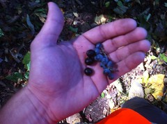
I did get a little help though. Stopping to pee, I discovered a bunch of plump wild grapes lying on the side of the trail, the vine that produced them dangling overhead. They were delicious.

CP4 was the Bear Creek Overlook, where a chainsaw crew was mowing down all the sumac that had grown up in the past year. We talked to them for a minute. They'd cut it now and burn it in the spring after it dries out.


 View from Bear Creek Overlook

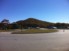
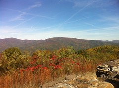
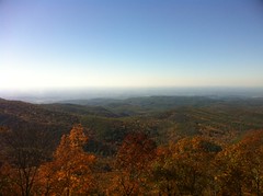
That's Fort Mountain on the far right, or Frog Mountain as the Cherokee named it. That's the ridge I was on earlier.

Marc, not quite ready for the photo.

 Marc at Bear Creek Overlook

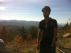
Me, also not quite ready.

 Me at Bear Creek Overlook

It was decision time. We'd hit the mandatory checkpoints, we could be done if we wanted. We'd only ridden 4 hours though, and I didn't feel like I'd gotten my drive-up's worth yet. It would take maybe an hour to get back. In one direction there was a single bonus checkpoint worth 4.5 hours - the Northern Terminus of the Pinhoti. In the other direction were 3 more worth a total of 4.5 hours. The second set were kind-of in the direction of MGap. If I could get those 3 and get back in less than 5.5 hours, it would be worth it. I knew I couldn't get the Pinhoti CP. I couldn't imagine anyone getting it.

Hirch had gotten his drive-up's worth, gave me his last Luna bar and bailed. Nam said they'd send out rescue teams at dark. I told him to tell her I had lights and fire, don't come looking for me until 10.

On the climb up to Potatopatch I stopped for some reason, not to pee, I don't remember why, but lo, at my foot, more grapes...

 Wild Grapes on FS64

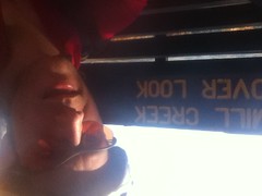
Precious calories. Delicious calories. Potatopatch is a tough climb. I recovered on the ride over to FS17 and felt good enough to go for the Mill Creek Overlook checkpoint.

On the way down I passed a guy walking up, pushing a cyclocross bike. "That'll be me in an hour." A minute later I passed a guy on a mountain bike climbing with no helmet.

I'd never ridden on that road, only driven down it, and I couldn't remember how far down the overlook was. It wasn't too far, maybe 2 miles.

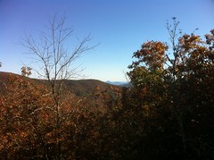
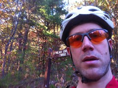
The view was pretty nice. That's Cisco down there, Chattsworth to the left.

 View from Mill Creek Overlook

It was tricky taking the photo. My disconnected brain couldn't figure out which way was up either.

 Me at Mill Creek Overlook

At that point, I think I was totally stoned on runners high. I leaned my head back to stretch my neck and got all dizzy and fumbly. I tried to count to 30 and realized I couldn't keep track of what number I was on or even remember what number was next. That's a new one.

The climb back up wasn't too bad, but I did have to walk a little. Grassy Mountain didn't seem too daunting. Apparently the clearing at the Grassy Mountain gate is the Hooty Payne Turn Around.

 Hooty Payne Turn Around

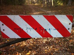
I thought I was the only one who saw that movie. Maybe only one other person saw it. IMDB doesn't even know about it.

(Update: Hah, I was thinking of the movie Pootie Tang. No idea what Hootie Payne is.)

There were 20 or more hikers at fire tower. Backlit by the setting sun, I didn't immediately recognize them as people. They'd come up the Tower Trail from Lake Conasauga. We chatted for a minute and one of them offered to take my picture.

 Me at Grassy Mountain Fire Tower

They couldn't believe how far I'd ridden or how far I still had to go.

It was getting cool, and it was going to be mostly downhill for a while. If my knees get cold, they get stiff, so I threw on the kneewarmers and bombed back down the tower road. Tibbs was a sketch-festival. My brother and I flew down it last year, but there was no flying today. Between the sun-glare, leaf cover and overwhelming chunk, I had to be extra careful...

But I did manage to pick up the last CP.

 Me at Intersection of Tibbs and Milma

Milma was easier than I expected. Except for the last few hundred yards, it was either downhill or easy spinning. The descent down Windy Gap was fast and fun. I mostly kept it on the ground, but I did wall-ride that one big berm.

At the Windy Gap lot, I ran into a guy, just sitting on his tailgate, listening to country music. "Didn't I see you come out of there last week?" "No, not me, must have been somebody else." "Oh, OK, have a good ride!"

I felt really faint bombing the fireroad, ate my last clif block and ran out of water. On the road, I could finally really feel that twisted chain link, and kept expecting it to pop at any minute. At Holly Creek, I tanked up, tied my orange vest to the back of my camel back and pulled out my light. Ohhhhh, crap. No helmet mount. No bar mount. No mount of any kind. Ahh, Adversity... I was wondering where you were.

I had four ideas:

* Just hold it in my hand.
* Tie my empty clif block wrappers together and tie it to my helmet with those.
* Tie it to my stem with my spare tube.
* Just ride in the dark.

I went with option 4, as, at any time I could go with one of the other options, and I had already started riding when I thought of them.

The road back to Mulberry was an infinity of anonymous gravel, mostly uphill. I've driven it a dozen times, but never ridden it. People dread it. It didn't seem that bad to me. In fact, it shone like an invitingly bright, white ribbon in the steadily darkening woods.

The sky was dimming, eventually I saw a star. At length I saw the church, the firetruck and the lights of Mulberry Gap. I didn't feel home until I saw my truck though. There's something magic about seeing your truck.

I have no idea how many miles or, more importantly, how many millions of feet of climbing it was. I do know that I bonked and recovered 4 times and cramped and recovered 4 separate times during the ordeal. I never felt strong, but it never sucked outright. Most of my body felt good. The two weeks off did a world of good. My neck did hurt though, and still does. I have more work to do there.

Back at the Rec Room, everybody was eating. They'd finished hours ago and had to wait for me. Ha ha! Except for the grapes, I'd been eating subhuman food all day. I was craving real food. Specifically, for some reason, I wanted a potato. Ginny had cooked up a stew, and in the stew, there were potatoes. Score.

The effort of my stomach crunching on the food made me tired. I stumbled around for an hour, showering, changing, packing up my gear.

The prizes consisted of Pez dispensers and random, awesome swag. I got 3rd.

 Winnings

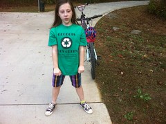
Eddie specifically instructed me that the Pez was for my girls. The next day, they were very excited to receive them.

It had taken me 8 hours and change. With 4.5 hours of time bonuses, that worked out to be an "official" time of 3.5 hours. The bonus CP's had been worth the effort. Hircsh took 5 hours without them. I think Andy got 2nd, by just picking up the 4 mandatory CP's in quick time.

Mulberry Gap native Andrew Gates got first by employing the ballsiest move of all time. He just f'ing manpowered his way directly to the Pinhoti Terminus and only THEN came back for mandatories. He suffered on P3, but ended with an inconceivable time of 1.5 hours. I guess that was the right strategy. That means it only took him 6 hours to ride that route. I seriously doubt I could do that loop in 6 hours, even on a good day. I hope to see him at the Fool's Gold next year.

I called Kathryn a few times and finally got a hold of her. Sophie was well, but Iz had gotten sick. She had been up all night with Sophie. I needed to get home to let Kathryn sleep and stay up with Iz if she ended up puking all night too.

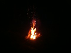
But first, a little recovery. I drank 2 Dr. Peppers and sat around Eddie's teepee fire. I'd built one of these at Tsali in like 1999 and it suddenly fell in one direction, almost on top of me. In this instance, a few little bits of it did fall outside the fire ring, but when the whole thing finally collapsed, it fell in a spiral, just like it was intended to. Impressive.

 Teepee Fire

When I was sufficiently sugared-up, I cranked some Ozzy and burned up the roads back to Cumming. I saw one deer, in a field, on the way home. That was the only wildlife I saw all day. In the summer, I couldn't do a ride without seeing all manner of animals. I see deer at all of the in-town trails. I'm telling you, they know it's hunting season.

Iz slept all night, but we had to curtail our plans to spectate at the Life University Cyclocross race. I'll likely catch whatever they had and puke my tract out later tonight, but for now, we're still on for trick-or-treating. Iz is getting her face painted right now. Mmm, free candy.

Monday, October 25, 2010

Buford Hatchery and Alpharetta Greenway

This weekend was murder. Iz stayed home sick Thursday, I caught it and stayed home sick Friday, then Kathryn caught it and was in bed all day Saturday. Sophie got it sometime up in there but not as bad as the rest of us. Saturday I had limited energy and just ran around in a vain attempt to get some errands done. Sunday was me and Kathryn's anniversary and I had about 10% more energy, pushing me just up over the go-do-something-fun threshold.

We caught fish.

 Sophie - Fish

 Isabel - Fish

 Kathryn - Fish

Or at least they did. I put a big chunk of sausage on a bass hook, hoping to catch a big catfish before every bream in the pond nibbled it away. Kathryn has caught them doing that, but no luck for me.

We fished for a few hours, then Kathryn went to help take down photos from an art show (that she got both 3rd in, and won the People's Choice Award. Woohoo!) and the kids and I went riding on the Alpharetta Greenway.

 Girls on the Greenway

Sophie was able to climb every hill with her new (Iz's old) bike, and they were both going way faster than usual. Iz is still tentative though, on pavement she rides like 50 feet back from Sophie. Of course, one time Sophie did stop suddenly, turned 90 degrees and begged us to T-bone her, so maybe Iz has the right idea.

We rode from Webb Bridge to Big Creek and back, maybe 15 miles. On the Big Creek end, Sophie had to make a pit stop.

 Sophie - Pit Stop

Iz was dancing and generally being weird.

 Iz - Being Weird

We saw 3 deer.

 Deer

I'm telling you, in deer season, they all go hide at the bike trails.

The fall colors are coming in, especially at the magic hour.

 Girls Heading Back

On the way back, we saw fewer and fewer people, and it got kind of dark. Not too dark to see, but dark enough to spook Sophie a bit. When we got back to the parking lot, ours was the only vehicle there.

Back at home, Kathryn had just gotten back, I grabbed a shower, my mom came over to watch the kids and we went out for dinner and a movie. Yay, 12 years.

Monday, October 18, 2010

Blankets Creek and Biello Park

Iz had her first gymnastics meet of the year today. She did OK. The skills are more difficult and the judging is much harder. It'll be interesting to watch her progress.

After the meet, we grabbed some lunch and headed up to Blankets Creek. Iz rode her gear bike off road with me a week or two ago, but since Sophie's upgraded to Iz's old 20 inch, she's only ridden it around the bank parking lot.

I hate to say it, but we had a very frustrating ride.

On the upside, they both rode pretty well, most of the time. On the bigger bike, Sophie had a much easier time keeping speed and rolling over the terrain and Iz was really getting used to using her gears. We spun a few laps on the Mosquito Flats and did a few out-and-back's on Hamilton's Hop.


The trouble with Sophie came when she'd stop. On her little bike, she could sit on the seat, put one foot on the ground, the other on a pedal, and start pedaling. This bike is too tall for that. She has to give herself a little push, then stand up on the pedals, but she refused to do that. No matter how many times I told her to or showed her how, or how many times she failed to get going with her way, she just refused to push off. She'd stand in the middle of the trail, spend 2 minutes getting the pedals in exactly the right position, try to get going, stall out, walk up 3 feet, and try it again until she finally got to a slight descent and could basically just roll down it to get going. I quit arguing with her after the 20th time. It wouldn't have been that big of a deal, but there was a lot of traffic, on those trails in particular, that day, and she kept blocking the trail, holding people up. Most people were cool, some were even out there with their own kids, but surprisingly many made sure to first get past her, then scowl at me or shake their head in disdain.

Whenever Sophie would stop, unless she was 20 feet back, Iz would try to ride past her, then scold Sophie for stopping. I must have told her 15 times not to, but she'd just keep doing it and argue "I'm not trying to ride past her" though she very clearly was.

We only had 2 mishaps. Iz's front wheel washed in a loose corner and she whacked her knee on her bars. Not 20 minutes later, Sophie washed in a different corner and ended lying down, face first on the trail, surprised, but unhurt. Iz, of course, tried to push past her and ran over her arm, pinning it down until Iz got off of her bike and moved it. It was pure luck that Sophie hadn't begin to get up yet or it could have been much worse. As it was, nobody was hurt, but that's what it took for it to finally dawn on Iz that it's dangerous to push past somebody like that.

And that's been the trend, of late. They only change their behaviors when painful, natural consequences force them to. I'm all about letting kids learn their own lessons, but increasingly, the consequences have been for somebody else. For Iz's impatience, Sophie's gets her arm run over, for Sophie's slowness, people get angry with me, and really, that's just scratching the surface. I hope they'll learn the bigger lesson soon. We'll see. Some people never do.

While sitting and waiting for everybody to calm down, we heard some rustling behind us. Four deer were nosing around in the brush, aware of, but unconcerned with our presence.


I know some hunters who haven't seen a single deer yet this season. I'm telling you. They know. They know it's deer season and they hide out at the bike trails.

Sitting there, I also realized that Blanket's Creek had become more like Blanket's Series-of-Ponds. This year's rain scoured out pools, felled trees and displaced a huge amount of rock. Also, the water level was super low. Inches. What was last year a creek was now a long series of natural coffer dams. There was movement under the surface, and if you looked at the rocks at the end of each pool, you could see water tricking around and under them. But it was a far cry from what I was used to seeing.

We probably rode 10 miles total and called it a day.

Or, at least a day on the bikes. We ran by the gas station at the corner of Sixes Road and 575, which, judging by the level of stock on their shelves, appears to be on it's way out of business, grabbed some snacks and headed over to Biello Park.

There, we threw the softball until everybody was sore from getting hit in the shins, knees, chest and fingers, then kicked the soccer ball until the blisters on my feet had blisters of their own.

 Kicking the Soccer Ball

Isabel's getting the hang of throwing the softball. They're both getting the hang of catching it. It's taking a while though. It's amazing what a difference not having a yard makes, or for that matter a flat driveway or street. When I was a kid, I was out in my front yard, every day, playing soccer, softball or football with my brothers and my neighbors or doing flatland freestyle on my driveway or in the street. We built slant ramps, quarter pipes, half pipes, launch ramps and rail slides and rode and skated them too. Heck, I used to just ride or skate around my neighborhood all day. I learned to do all of those things early and got plenty of practice. Except for basketball. I have always sucked at basketball. But basketball aside, none of those things are possible at my house. Our house is built into a hill, in the woods. We have no yard of any kind. Or driveway is too steep to drive up in the snow. The streets are too still too steep for the kids to ride on. We have to pack up the truck and drive to a park or somewhere to do things that I could just do out front of my house. To an extent, I feel like I've deprived my kids of some of the joys of my own childhood.

When I got home, I took a look at my feet. Yep. Double-layer blisters. It's hard to walk, but at least every step reminds me of the fun I had getting them.

Sunday, October 17, 2010

Brasstown Bald

My brain isn't biked out, but my body sure is. I've been managing pain in the back of my right knee, the arch of my left foot and my neck for a while now. I want to ride, but I need some time off to heal. Two weeks ought to do it. No commute this past week, no group ride, and yesterday I walked all over the place.

A while back I uploaded a bunch of USFS GIS data into my trails site and found out about a bunch of hiking trails that I had no idea were there. A couple around Brasstown Bald piqued my interest and yesterday I got a chance to check them out.

My plan was ambitious, at least for me: park in Young Harris, take the Wagon Train Trail south to Brasstown Bald, head west on the Arkaqua, then jog back to Young Harris on the road, or at least jog as far as I could and walk the rest. Wagon Train is like 6 miles, Arkaqua is 5.5 more, and who knows how much on the road, at least 7 or 8, plus a mile maybe from Young Harris to the Wagon Train proper. How would I fare? Lets find out...

It was tricky getting to the Wagon Train trailhead. After one wrong turn, I found it, sitting there, anonymously. You just have to know it's there.

 Wagon Trail Trailhead

At first it was a gravel roadbed. It didn't look like it got much use, but it looked maintained.

 Wagon Trail Roadbed

I met a trio of hunters, heading back from their hunt, about a quarter mile in. Camo is one of those things that I never expect to work when I see someone wearing it in a gas station or getting out of their truck. How could it possibly do anything? But I've been surprised several times. In the woods, I've gotten really close to hunters and Army Rangers before realizing they weren't just part of the woods, and then, it was only the movement that gave them away. If they hadn't wanted me to see them, I wouldn't have. It makes me wonder how many times I've walked or ridden right by a hunter or Ranger, hiding in plain sight. Walking up the trail, I was just looking down, looking around, then suddenly an orange square appeared, floating toward me in mid air. "What the heck...?" and only then did I realize that it was the orange vest of an otherwise camouflaged hunter. Actually, there were three of them walking single file. Once again, I was amazed how well the camo worked.

(I was wearing my orange vest too)

"See anything at all today?"

"Nothing all day. Good walk though. Nice day to just have a look around."

"Man, I'll tell ya. Wagon Trail this way?"

"Yep, just up the road."

They were right too, it was a really nice day. High 50's, not a cloud in the sky. Just up the road, I hit the wilderness boundary and a USFS-looking gate. The trail beyond was an old roadbed, but oddly enough, not an old logging road. Legend has it that the road leading up to Brasstown Bald from Hwy 180 had been cut all the way through to Young Harris, but only finished from the highway to the top of the mountain. Eventually the land it ran through became the Brasstown Wilderness and the road became a trail. Locals called it the Wagon Train Trail, presuming it was just that. It was apparently built more recently than that, though I'm not sure exactly when.

At any rate, after the initial climb up from Young Harris, the trail flattened out a good bit and became much less strenuous. A ribbon of singletrack lay on the outside edge of the old roadbed which meandered along the contours of the ridge.

Frequently, the ground was covered with fruit. Wild grapes and possibly some kind of cherry? The grapes tasted like grapes and had lots of small seeds. The cherry-things had a single pit like a cherry, but I'm always wary of cherry-looking things that I'm not sure of. Anyone know what these are for sure?

 Grapes and Cherries

They were everywhere. I couldn't tell what tree they were falling from. I could identify everything above them (or at least I thought I could), and none of those trees bear fruit like this. Weird.

At Double Knob Ridge, I was surprised to find another gate...

 Wagon Trail Former End

...apparently this was the edge of the wilderness, some time ago.

For a while, the canopy over the trail was thin, and these flowers were everywhere.

 Flowers

The trail itself was really nice. It looked like a lot of work had been done on it. Brush and debris had been piled up on the inside. The trail mainly ran along the outside edge with gradual turnouts every so often. Each turnout was armored with rock. Here and there, the trail meandered across the road. "Turn the trail, not the water." Some of the erosion control structures were pretty elaborate.

 Erosion Control

Maybe we could use something like that up on Bull Mountain.

A few sections reminded me of Laurel Mountain; rhodo tunnels, paved with yellow leaf litter.

 Leaf Litter

Further on, a cliff face formed on the east side of the trail. Not a natural cliff, the blasting scars were still visible.

 Rock Wall

It went on for miles, and I started to appreciate the engineering involved in building that road. I don't know of another road in Georgia that required as much blasting to complete. Maybe some sections of Hwy 76. All that work, and it was never finished. I wonder if it was ever open to vehicles.

Now and again, I caught glimpses of the neighboring ridges and the valley below through the woods to the west, but never got a good, clear view... until suddenly I did.

Brasstown Bald...

 Overlook - Brasstown Bald

Not too far to go. But it wasn't exactly close either.

So far, the trail looked like it got light to moderate traffic, maybe like the Duncan Ridge gets on Duncan Ridge proper, but from there on, it looked a good bit more worn in. Before long I started seeing day hikers on out-and-back's from Brasstown. I talked to one family for a few minutes.

Near Brasstown there was this little monument, just off the trail.

 Old Brit

For a dog? Maybe?

The trail ended as anonymously as it began. It just teed, unmarked, into the road that the shuttles use to ferry tourists up to the observatory from the parking lot. There is a plaque where it crosses the Summit Trail and a gate and kiosk down the trail a bit, but at either end, you've just got to know it's there.

The Brasstown Bald parking lot was just a few hundred yards down the road and it was buzzing. I've been up there a half-dozen times, but never in warm weather and never in the middle of the day. Popular place.

 Brasstown Bald Lot

A nice side effect of arriving during tourist time... The general store was open.

 Brasstown Bald General Store

I'd brought food, but I was dying for a Coke. And there was peanut brittle. Score.

I sat down on a bench, snacked, drank, talked with an older gentleman down from Virginia (if memory serves) and eventually started moving again.

I'd felt good all morning; strong legs, solid feet, smooth joints. Standing up from that bench though, I realized that the suffering just hadn't set in yet.

Blisters. Dangit. I thought I was harder than that.

No time for self doubt, better get moving.

The Arkaqua was a lot different than the Wagon Train Trail. Newer, bench cut singletrack and very well worn in. It started out gentle enough, meandering through rhododendron, and I kept catching whiffs of that cinnamon scent I smell up at Bull Mountain all the time. On the approach to Chimney Top, the trail got rocky and chunky.

There were a series of overlooks up there.

Mt. Yonah, south of Helen.

 Yonah from Arkaqua

Brasstown Bald.

 Brasstown from Arkaqua

Brasstown Valley.

 Valley from Arkaqua

I've joked before about the lack of creativity involved in naming North Georgia geography. I know, for example, of at least three Wolfpen Gaps. This one takes the cake though. Standing on Chimney Top, I could see another knob, also named Chimney Top, on the ridge I'd walked in on a few hours ago. By the way, that ridge's name: Wolfpen Ridge.

Beyond Chimney Top, the trail got really interesting. There were a few tight squeezes. I came down through this one.

 Tight Squeeze

And there were endless, steep, twisty, rocky staircases.

 Rocky Climb

It was about here that my right thigh really started to hurt. Like pulled muscle hurt. Come on! I was out hiking so the rest of my body could heal. Busting up something else wasn't part of the plan. As bad as it hurt, it might still be OK. About six years back, maybe more, I crashed at Blankets Creek, bruising my thigh from knee to hip against the bars. Eventually, the bruise turned into a string of little knots. I stretched and stretched and tore at the adhesions or whatever they were for years. Whenever I'd tear a new one, it always hurt, but it didn't affect my strength. This could just be more of that. There's nothing like steep down-hiking to put a ton of strain on your thighs. They're always tense. More tense or less tense, but always some kind of tense. And the stair steps on this trail just put down hit after hit after hit. If that's what was going on, I'd be OK, it would hurt, but I could keep going. Time would tell.

At Low Gap there was this big block of quartz or something.

 Quartz Block

Somebody put in some effort to get that block of rock there. I didn't see anything like it on the adjacent hillsides. It wasn't just rolled downhill. How'd it get there? I sat down, had a snack and stretched my thigh out for a few minutes.

The descent to Trackrock Gap Road was a long, sustained, thigh-crushing, switchback deathmarch. On the upside, my right thigh wasn't getting worse and stretching it out had helped a little. On the downside, I had forgotten my post-Smokies vow to buy a new pair of shoes. On a long (or wet) hike, my feet swell and eventually, no longer fit in these shoes. The toe box is narrow to begin with, and with the swelling, the toe-crushing is epic.

The pavement was a welcome sight.

 Trackrock Gap Road

If you've never hiked a road before... After a reasonably long trail, it feels inconceivably hard. Like some kind of medieval foot-spanking torture. But it passes. And the road was infinitely shallower than the trail. I was glad to be on it.

I jogged north for maybe a mile before my toes couldn't take it anymore. I took off my shoes and walked in my socks. That was tough on my heels, but hey, one or the other. See Rule 5.

Wolfpen Ridge. I was up there earlier.

 Ridge From Hwy 76

It must have looked funny, but I'd walk in my socks until I didn't feel like doing that anymore, then I'd slide my shoes back on and walk in them until I didn't feel like doing that anymore either, then I'd switch back to the socks. Over and over. Who knows how far it was. 8 miles?

The sun was just starting to think about setting. The breeze was cool. The traffic was light. If it weren't for my toes. It would have been pleasant.

A kayaker stopped and offered me a ride. "No thanks, I'm good." Gotta run what I brung.

This sign was appropriate.

 Walk Humbly

Every day brings a new opportunity to walk humbly. Yesterday's opportunity was just a bit more literal than usual.

Signs of progress.

 Towns County Line

I wished I was on a bike.

 Long Road Ahead

I wondered how many people mistook me for homeless.

I started recognizing restaurants and shops.

Getting close.

 Young Harris City Limits

Done.

And only a few minutes after dark. There's nothing like finally seeing your truck after a long day of walking.

I didn't even have to think about where I was going to eat. I'd walked past it a few minutes earlier.

 Moschettos

Chicken and Rice Soup, bread and Shrimp Carbonara. Oh yeah. Sitting for so long though, the pain set back in. The walk across the parking lot sucked.

It was in the low 40's outside. For some reason, and it only seems to happen when I'm hiking, not on the bike, if I've been going all day, get really tired and then relax in a warm place, then go back out into cooler weather, not cold, but maybe like 10 degrees cooler, I'll start to shiver uncontrollably until I get warm again. It's weird, and it happened again as soon as I got back into my truck. I pretty much just had to sit there shivering until I didn't shiver any more.

What a day. I learned a lot. Mainly, I'm buying new shoes at the next opportunity. Also, the road-hiking sucked less than I thought it would. It wasn't bad at all, actually. I'm not sure I'll do that particular route again any time soon, but there are plenty more where that came from. On to the next one.