In the late '90's before I even moved to Georgia, I'd heard tales of a trail in Anniston Alabama. Iron Legs they called it, and having just recently begun to ride, the name struck such fear in my heart that even though I made several road trips to Oak Mountain and Tsali, and passed directly through Anniston, I dared not attempt the loop.
Since then, my mountain biking has improved slighty, but it never seemed worth it to make the trip to Anniston to just ride that one loop. With the recent opening of the Coldwater Mountain trail though, and the subsequent, widespread approval from the general mountain bike community, Tim suggested that we head over there for a Tour de Anniston of sorts and that sounded like a great idea. Apparently there are other trails in the area too. Who knew? Actually, you'd think I'd have known, seeing as that's kind of my thing, but in this instance, nope.
Saturday the Frere called, wanting to ride at Bull. I countered with the Anniston idea. He lives like 45 minutes from Anniston and before I was even done with the proposal, he was in. Maybe we could all go. I tried to get a hold of Tim, but I'd apparently lost his number in the Great Drenchening a few weeks back. Facebook came through for me but he was already headed to the beach. Dangit! I guess if you're going to miss out on a ride, a beach trip with the family is a pretty good reason.
I met John at the Douglasville Park and Ride and we headed west immediately. It was a little tricky to find the Iron Legs Lot though. It's not a parking lot, per se, but just an anonymous turn out off of the road.
Back up the road there was a more likely looking lot, but it turned out not to be the correct one. That lot had a very interesting feature though, a single grave site, perched on a hump of ground, bordered by the road to the south and encircled by the turn-out.
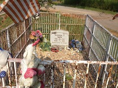
3 years old. Terribly tragic. Now I want to know the story. Somebody knows, I'm sure. I bet if I went to a nearby gas station the clerk would know. I need to start doing that for these kinds of things.
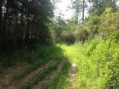
When we finally found the lot, we hit the trail. It was a sandy fire road at first but it narrowed down by degrees and eventually became glorious singletrack.
Glorious!
Whoever built that trail knew what they were doing too, even if they didn't know that they knew what they were doing. It was especially amazing, given how long the trail's been around. The trail followed the contour, it had grade reversals, here and there it ran up or down the fall line, but only where the soil was extremely rocky and durable. It was smooth and flowy and rough and technical and there were switchbacks and runouts and man! This is what I'm talking about! The trail was IMBA'ish but it was still very technical because someone found technical terrain and ran a trail through it. They didn't just rely on massive erosion to create technical features for them. We need more of this. Ironic that this ancient, pre-IMBA trail is a decent example of it.
I really dug Iron Legs. The only complaint that I have is that I was able to ride all of it in my middle ring except one really loose section where they'd recently cut a fire-break coincident with the trail. I'd hoped to have truely needed legs of iron.
Actually the only other complaint that I have is that it wasn't longer. I think the loop was around 6 miles, and it's a long drive for a 6-mile ride.
It's rare that I get an opportunity to take photos when I'm riding with John. Either I'm chasing him down or he's right on my back wheel, and we're rarely creeping along at photo-op speeds. There was one really cool point of interest though, that I had to stop for.
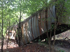
I don't know if that's an old fuselage or just a mock-fuselage, but either way it was wild. I rode through it.
The whole are was once part of Fort McClellan, and there's allegedly an old mock Vietnamese Village out there somewhere too. We didn't see that, but apparently there's a rock garden in the area too, so we could have ridden right through it without raising our eyes from the trail.
The last little bit of singletrack appears to have been totally abandoned, I'm surprised we were even able to find it, actually, and where it once led across a field, it's totally overgrown so we had to field-whack a little there. When we were done, we ended up back at the grave site and took the road a block and a half west to the car.
Having recently gotten my bikes fit, I had been really unsure of myself for the first few miles, as this was my first mountain bike ride since. I felt way more powerful climbing but the geometry was different and it just felt strange. I had a little trouble twisting around but only because my instincts needed to be retuned. For the middle couple of miles I had to think about what I was doing, but for the last few, everything seemed natural again. There was only one little downed tree though, so I was still unsure how well I'd be able to get the front end up.
Next up, Morgan Mountain. The trailhead was just up the road and a little less anonymous than the Iron Legs lot.
The most interesting feature of the Morgan Mountain Lot was the goose carcass that we passed on the way in.
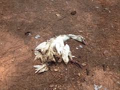
Zoom in on the beak and notice the weird tooth-looking structures there. Weird. It reminded me of those Archaeopteryx skeletons with the teeth. I wonder if they had beaks too, that just deteriorated away and left the skull and teeth behind. These are the kinds of things I think about, for some reason.
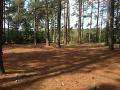
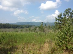
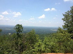
We started out on Marks Loop, which wound around through the woods a bit before busting out into what I guess is what's left over from a clear cutting timber operation. The view was pretty nice from there.
Then it wound around some more, crossed a road and disappeared entirely. The map showed it sidehilling up and around the mountain, but no discernible trace of the trail remained. Dense weeds obscured it completely. Maybe if I was really, really familiar with the route, I'd have been able to follow it, but after trying for a few minutes, we gave up, took a logging road back to the main road and took that back to the lot.
We rode the rest of Mark's loop backwards from there. That section was apparently once an asphalt road. Here and there, short stretches of it poked up through the pine needles and the root mat. I've seen plenty of trails on old, overgrown dirt and gravel roads but an old, overgrown asphalt road was a new one for me.
The other chunk of the trail teed into that logging road we'd been on before. Not sure how we missed that intersection, but we did.
We tried riding the "Family Trail", but it too had been obliterated.
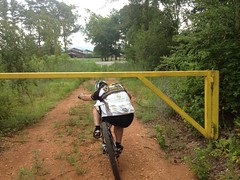
We basically ended up riding various loops out to that logging road and taking the main road back, three different times. There was a gate at the end of the logging road and we got reasonably good at limboing under it.
Man! That sucked, and it looked so promising on the map. Maybe Gene's Loop would be better.
Hmmm. No such luck. It had met a similar fate - clearcut logging had completely removed a huge chunk of the trail. In the distance I could see the mountain that it must wind up and around, but getting to it was impossible.
We tried hard to ride Gene's Loop but there just wasn't enough of it left to do very much. I did manage to hop a half dozen downed trees though, of every conceivable size and orientation. Apparently, even with the new fit, it's not that difficult.
Next.
Coldwater Mountain!
Ok, this trail had to exist because it opened just a few weeks ago.
And boy did it exist.
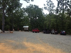
The parking lot was a bit less anonymous than Morgan Mountain. There were no bathrooms or water but it had gravel to park on and a kiosk with a map.
The trail was amazing.
The first mile or so was all rolly-flowy with dozens upon dozens of little jumps - singles, shallow doubles and tabletops.
Then there was about a 3 mile climb with long runs and several groups of switchbacks and rock gardens and stretches of just rocky, chunky trail. At the end of the climb, it joined an old, semi-rutted fire road for about 100 yards before finally peaking out.
For the next half mile or so it twisted downhill alternating between smooth flow and brief rock gardens, then the jumps started again. There must have been hundreds. Hundreds! Waaaaaaaa! They seemed to be in 3's or 4's, but that might just have been how my brain processed them. Jump, jump, jump! A lot of them looked like if you got enough speed to double the first one, then you'd float over the next two. It was tough to commit though. I wasn't familiar with the trail and doubles always make me nervous. Eventually I started manualling them, then I hit a couple of small ones, but I never got the courage to float the longer ones. John did though. We alternated who led and he pulled away from me easily. Damn. I need to ride there more often.
There was even a great view at the top of one of the berms, and a long line of sight so you could easily see people stopped there.
Awesome.
I didn't even notice the new fit on any of the jumps. I was worried riding into the initial descent that the seat height would be a problem but like half a mile it felt natural and eventually I just forgot about it.
After the long descent, there was a half mile or so of climbing, another long descent and then the climb back out. At least, that's how I remember it.
As we began the climb back out, we passed a lady, taking a break. A half mile or so later a kid came riding toward us, half frantic: "I'm sorry! I'm sorry! I'm sorry!..." The trail is directional and he was riding backwards, thus the apologies, but his tone of voice was disconcerting.
John: "You ok man?"
Kid: "No, I've lost my mom!"
John: "Does she have a black bike?"
Kid: "Yes."
Me: "Does she have a frog tattoo on her calf?"
Kid: "Yes!"
His mom was the lady we'd passed. She was 10 minutes back or less, and she seemed ok when we passed her. The kid was out of water though. I gave him my bottle. It was only half full, but it was all I had.
That's how hot it was, by the way. I drank a bottle and a half in 8 and a half miles.
John suggested he rest in the shade and wait for her. She would be along soon.
Turned out his dad was back at the lot and we told him what was up too.
I wanted data for the short little beginner loop so I tanked up my other bottle and spun that loop. The kid's dad was walking toward me as I neared the lot. Uh oh. They hadn't returned. Maybe they'd had a mechanical. Maybe they'd run out of water again. Hmmm...
I headed back in their direction. My heart sunk when I passed the spot that we'd left the kid earlier. I finally found them another quarter mile down the trail. He'd gone after his mom, they were now both out of water and had begun walking back to the lot.
Ok, never mind what I said earlier. The mom had drained a 60 oz camelback in 8 miles. THAT is how hot it was.
I gave them my other bottle. I met the dad again on the way up again and a buddy of theirs was a hundred yards behind him, jogging two Powerades down. I thought of offering to take them down for him but I saw his "Tri-State Adventure Race Team" shirt (or something like that), and I figured: "He's got this."
And so it was, no crisis materialized. The whole family arrived back at the lot eventually and the adventure racer emerged from woods after having freehand nav'ed himself back to the lot. I got my bottles back. All was well.
Me and John grabbed some Zaxby's in town and eventually made our ways back to our respective homes.
Oh, man, Anniston is great. It's too bad I didn't get to ride Morgan Mountain and Gene's Loop when they existed but there are apparently even more trails out there, so I'm going to have to go back sometime soon. Maybe me and Tim can go next time and he can show me around for real.


No comments:
Post a Comment