A few weeks back, Me and Clark and Suzy planned on doing some exploring of the general Upper Chattahoochee area. Fate intervened though, the night before they got sick, and our plans fell through. Turns out they didn't miss much, but there's plenty more up there to explore, so a few days ago we made new plans, this time nobody got sick, and today we met up for some world-class bushwhacking.
We'd actually planned on riding a loop of FS44 and stashing the bikes here and there to run off and explore side trails. To that end, I'd even brought my bike up with me. But.... Clark had recently traded in his truck and only the night before realized that his old roof rack clamps wouldn't work on the new roof rail design. For the first time in as long as he could remember, he had no reasonable means of transporting bikes, or at least, no reasonable means of transporting 3 bikes and 3 people. Nor did I, for that matter.
It's funny what curveballs life can throw at you. None of us saw that one coming.
No matter though, I'd brought an extensive pile of gear and aside from having to borrow a bladder for my camelback, I was set.
Let it begin!
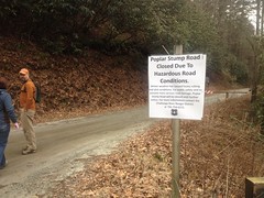
It began where it usually does, at the no-camping-here campground off of FS44. Apparently, since the last time I'd been up there, a landslide had wrecked part of the road though, and the gate just north of the parking area was closed.
Wild!
I'd never even noticed a gate there before, let alone seen it closed.
No matter again! We walk!
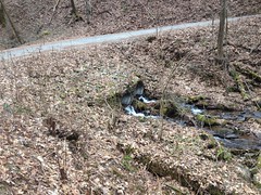
Our first objective was a waterfall that I'd caught a passing glimpse of last time. I've ridden by it dozens of times, but usually in warmer weather with more leaves and less water, and as such, never seen it until a few weeks ago. Makes me wonder what else I've missed over the years.
Walking on the road always seems to take longer that it does. It seemed to take forever, but we actually arrived at our destination in good time. Our destination was the oddly named "Double Culvert Branch". I guess because of the double-culverts used to divert it under the road?
If so, Clark gives them an F for creativity.
My iPhone died immediately after taking that photo. I can only remember one other time that happened. I guess I should have plugged it in last night. It said it was half-charged this morning. I guess half a charge gets used up quickly in cold weather.
Clark and Suzy both still had functional picture-taking devices though, so the remaining photos are courtesy of them.
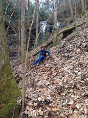
A more-or-less discernible trail led up along the south side of the creek and we followed it.
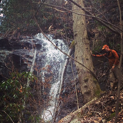
After a sketchier-than-it-looked creek crossing, we found the lower cascade...
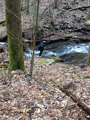
...but the upper cascade raged on above us and we had a little more work to do to get to it.
This work included a challenging boulder scramble, slippery rocks, and with all the rain and snow lately, soft soil barely covering slippery rocks.
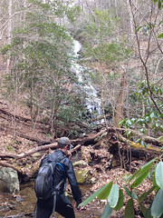
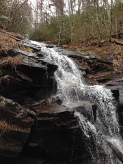
We eventually made it to the main cascade, which was massive and unlike most north Georgia waterfalls, actually fell over rather than slid down the rocks.
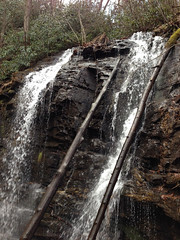
For a no-name, unmapped, unsung falls, Double-Culvert is impressive and worth the effort to see. I wonder though, in the summer, if it's more than a trickle. I guess I'll have to come back and find out.
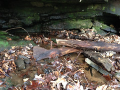
Milling around at the base of the main cascade, I noticed something unnatural-looking across the way. It looked like an old piece of wood with an iron spike sticking out of it.
No way.
Upon closer examination though, yes way. It was exactly that, right there at the base of the falls, tucked up under a little rock overhang. Looked like it'd been there a while.
The Byrd-Matthews lumber company inundated the forest with trestles and locomotives in the early 1900's to get trains in and logs out. When the timber was cut, they'd tear up the tracks and reuse them somewhere else. Could this be a forgotten artifact of those days? Was there a trestle here, or did that board wash down from higher up the mountain?
Questions, questions... Frustratingly few answers sometimes.
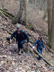
The descent back to the road was even sketchier than the climb up and Suzy didn't take any chances.
The walk back didn't seem to take as long as the walk out. We saw a lone bike tire track on the road, but never ran into the owner. We did see two trail runners come out right after we did though.
Not being on bikes ourselves, we actually had a few more options than we'd otherwise have had. Clark and Suzy had recently been up to another obscure waterfall off of the Andrews Cove Trail. Including it in our original plans would have made for a long ride, but it wasn't a big deal at all to drive there.
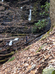
Objective 2: obscure waterfall off of random feeder creek of Andrews Creek.
And there it is.
How anyone knew it was there is beyond me. One of their friends knew it was there because someone told him. Who knows how long that knowledge has been passed down.
There was an old, overgrown roadbed leading right to the falls, but we didn't notice it until we'd already gotten there cross-country. We followed the old road out, but it just curved around weirdly and didn't appear to cross Andrews Creek. It was a road from nowhere, to nowhere. Obviously that doesn't make sense though. There were remnants of old roads across the creek, so it must have somehow hooked up with them, but it wasn't clear how. Perhaps there was a massive bridge there once. Point is... if you didn't know it was there, you'd likely only find it if you made a point of decoding the old overgrown system of roads, which were so overgrown, even I'd have given up on them before I found the falls.
The only other likely way you'd find it is by looking at a topo map and deducing that there might be a falls there from how steep the terrain is. The other feeder creeks lie on equally steep terrain too. Maybe we should go check them out too.
Hmm, actually, now that I think about it, I guess another way a person might find it is if they were wandering around over that way hunting or scouting. I guess there are quite a few ways people might discover and rediscover that waterfall. That last one actually sounds fairly likely now that I think about it.
So maybe not such a mystery after all.
Next!
Like two or three years ago, we'd followed Old FS44C out to a food plot and found that the old road hooked hard leff off into the Mark Trail Wilderness. It was too dark to check it out, and it was snowing too, so we filed it away for future exploration. Today was the future. The future! And Old 44C was our next objective.
FS44 was closed just past the Upper Chattahoochee Campground though, and once again, we were walking.
We did get to see the landslide though. It's funny. There'd been a landslide a few years back, that had been repaired with a concrete retaining wall and some new culverts. This time, two separate landslides had occurred to either side of the old one. The repair was less elaborate this time though. It looked like they just realigned the road, laid down some gravel, spread hay on the displaced earth, and positioned a few pretty large boulders on the edge of the road. The repair appeared complete, but the road wasn't open yet. Maybe they're waiting to make sure it's stable. Probably a good idea.
Our objective lay in the next curve after the landslide. We followed the old road as far as it went. It was punctuated. Well maintained to the food plot and abandoned beyond, but had clearly been maintained not too-too long ago. Eventually there were Kelly Humps, the old road narrowed, and became quite overgrown. Near the top of a little knob, it just blended into the background.
The top of the knob was choked with knee-high little sprigs of god-knows-what. If it'd been summer, we'd have been challenged to even see the ground through the leaves. As it was though, in winter, with no leaves, it looked easily passable until you tried to push through it. My ankles are now, officially, shredded.
It didn't occur to me until a few minutes ago that the top of that knob may once have been another food plot, and that the road might actually continue on the other side even though it appeared to end there. That said, even if it had, I'm not sure I'd have wanted to follow it.
On the way back down, I ended up tripping over something, I don't even remember what now, and very slowly falling all the way to the ground. I ended up on my back, with my head aimed downhill, wrapped up in whatever I'd tripped over, and it happened slowly enough that I was able to continue whatever conversation we were having as I fell. It was funny, I kept thinking somehow I'd save it, either by extricating my foot, or by putting my hand down and regaining my balance. I didn't get my foot loose though, and my hand just slipped slowly as I fell. Clark joked that I'd crashed, like on a bike, but on foot. It felt like that. It was definitely one of the strangest crashes I've ever had.
Also, I can't remember if it was on the way out or back, but we saw like 20 or more turkeys hanging out on the road. At first they looked like pigs. Clark thought they were until they started moving. It's good that they weren't. I'm not a big fan of pigs, live ones at least.
There was one last objective on our list, or at least on my list. Naked Mountain Branch. Or Hanson Branch which then becomes Naked Mountain Branch, or something like that at least. Low-resolution USGS topo maps show a trail leading up along those creeks and tying into FS44F. Did it exist? I wanted to know.
Yes! It did, and it was scenic, and easy to follow until we got to a creek crossing where you had to drop down about 4 feet, walk through torrential foot-deep water, and then somehow climb back out on the other side. The alternative was to clamber up onto a downed tree suspended several more feet up above all of this, balance-beam across it and leap onto the other bank from several feet out. I did that, and it was so sketchy that I couldn't, in good conscience, recommend it. On the other side, the trail was clear, and begged to be followed, but the day was wearing on, we'd already walked 10 or 11 miles, and Clark and Suzy's small herd of dogs were undoubtedly spinning in circles, anticipating the opportunity to use the facilities. "Any minute now, any minute now, any minute now!"
It seemed like a good idea to pack it in and just add that one to the todo list.
The dogs were very happy to be let out and fed. We were eager to be fed too, and topped the day off with chicken parm sandwiches at the Nacoochee Tavern, where a "half-sandwich" is a foot long. We all three ate chicken parm sandwiches that we'd all three decided to get independently. Great minds think alike, I guess. Heh, heh.
Oh man! What a day! Infinitely more satisfying than the last time I was up there. Infinitely! I'm eager to reprise but I'm not so sure when that opportunity will present itself. Money's tight. The gas alone, and hell, even the opportunity cost are significant these days. At least, when I get the chance, there'll be plenty to do.
Until then...


No comments:
Post a Comment