White Oak Mountain again...
I wanted to ride the Noontootla-Winding Stair loop, or the Continental Divide Loop, or some other long gravel grinder, but the weather forecast called for a 100% chance of rain, all day, for the next two days, and I couldn't bring myself to ride in it.
However, as it appeared to be a 100% chance of drizzle, as opposed to proper rain, I could easily bring myself to hike in it.
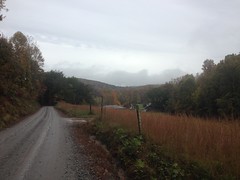
I felt like I'd just scratched the surface of the White Oak Mountain system last week, so I made my way back up that way again. This time though, from the other side.
The Kellum Valley side.
Though nestled into the National Forest, at first glance, the Kellum Valley seems almost devoid of public access to it. The Logan Turnpike trail leads from the end of Kellum Valley Road up to Tesnatee Gap, but you have to correctly interpret some ambiguous and imposing-looking private property signs to get to it. There's also FS57 which leads off to the east, but it just looks like somebody's driveway. Unless you know it's there, you could easily miss it.
It is there though, I knew about it, and that's where I went.
I did spend a while figuring out where to park though. FS57 itself had a deep mud hole almost immediately, people's properties tightly lined the main road, and north of the NF boundary, the road leading to Logan Turnpike was a mess. I'd have braved it in the Durango or the Subaru, but I had less confidence in the Saturn VUE. I ended up parking along an unposted stretch of road with infrequently-used-looking trailers to either side, and hoping for the best.
It was a bit of a jaunt to FS57, and then a bit more of a jaunt to the end of it. On the way out, I checked out several little side trails that just led up or down to flat-ish spots. It seemed like there might have been properties back up in there at some point. I could imagine that along that road, it might once have looked much like it looked along the roads of the valley below - houses notched into the hill with fields and pastures beneath them.
One of the side-trails looked like a popular spot to gather firewood, and somebody appeared to have lost their hat during one such gathering.
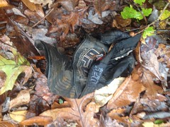
I hope it wasn't the same guy that lost that jacket that I found last week. If it was... poor guy.
Side trails and mud holes. That's FS57 for you.
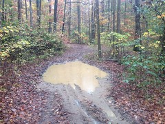
Each mud hole bigger than the last.
And down at the end of the road, the Forest Service made sure that you knew that it was the end.
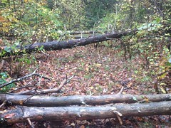
There was a big set of berms too, and the culvert had been ripped out of the stream that crossed the road there.
You shall not pass!
Well, except on foot.
It's funny, when I first went exploring back there, way, way back, there were no berms, no downed trees, and the culvert was intact. There was no indication that the road was supposed to end there, and I drove all the way to the next ripped-out culvert, figuring that was the end. It wasn't until I compared my GPS data with the USFS's official GIS data that I realized where the real end was supposed to be. There's no question now though.
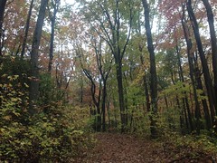
It's still trying hard to be fall up there, and the trees were changing colors. The oaks are still holding out, but everything else is turning red and yellow.
I explored several more side trails, one of which turned out to go and go.
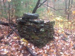
Actually, it appeared to be 3 separate trails, all old roadbeds, with little connectors between them. Together they conspired to sidehill along Pinnacle and White Oak Mountains to a bit of a flat spot with a bunch of rock piles all over the place.
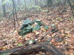
Natural occurrence? Indian graves? Did people just move the rocks to clear the path when building the road? I want to know!
From there a well-worn trail led on, for like a mile. It was clearly not an old road, not an ATV trail, and not just a pig trail. This was either foot, horse, or both.
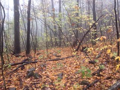
It's not unusual to see short little trails leading off the end of an old road. Hunters seem to end up making little short ones off the end before they start off cross-country. I've seen a few get longer and longer over the years, and they're more distinct mid-deer season. But, it's unusual to see one go for more than a few hundred yards. This one was over a mile. It was clearly there on purpose, but it didn't look built, just worn in over the years.
It eventually teed into a familar trail and I took it to White Oak Gap.
I was getting pretty hungry at that point, so I grabbed a bite to eat. There were no logs to be found, and few rocks, so I settled down on a 3-inch tall block of quartz, barely wide enough to call a seat, and ate the remainder of some Skittles from the previous week, and half a beef stick. It was in the low 60's and the rain was light, but fairly steady at that point. I remember sitting there, thinking: "I'd bet that on paper this wouldn't sound like a good time..." but it was. My clothes and shoes aren't uncomfortable when they get wet, and I'd been moving all day so I was done eating before I started to feel cool.
Yep, good times.
I explored the general White Oak Gap area, and found this disgusting old rope tied around a limb there.
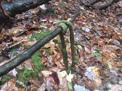
There was an actual gnarly old White Oak there at the gap, from whence it gets it's name, I presume, but the old oak has seen better days, and a significant amount of it had come crashing down across a little spur to the southwest, a while ago. The rope was tied to one of those limbs, way up in the tangle. This begged the question: "Was it tied there before, or after the tree fell all apart." It looked really old, and given its position in the tangle, it seemed like before. If before though, then what was its purpose, way up in the tree?
These are the questions that weird old artifacts raise. Somebody knows the answers, but it's likely I never will.
Speaking of old artifacts, I ran into this old chimney ruin in the Turner Creek draw, below Big Gap.
Somebody lived up there, some time ago.
I spent the rest of the day following dotted lines on my map - trails that I'd seen before and supposed went somewhere. They did, mostly, but none were as interesting as the long one I'd found earlier, and I didn't find any more old artifacts or ruins.
The time change is a heck of a thing too. It was officially dark well before I emerged from the woods. It was pitch black as I walked along the main road back to the truck. Two cars passed me on that road. I gave them the nod-and-wave. Hopefully the fact that I was jogging, wearing dorky clothes, a camelback, and an orange vest made it look like I knew what I was doing, and that what I was doing wasn't something untoward like robbing their houses or something. It seemed to, as they kept moving. No questions, no threats.
Fine by me.
Another heck-of-a-thing that the time change does is get me out of the woods fairly early. All summer I'd been getting home between 11 and midnight. I managed to drive a good bit further east to Helen for some enchiladas and still get home before 9:30.
Heck of a thing.
I'd been thinking about enchiladas for a couple of weeks, ever since me and Clark and Suzy went wandering around Raven Cliffs. Sadly, they didn't live up to my expectations, though I think that has more to do with my inflated expectations than the quality of the actual enchiladas. I do know where to find good enchiladas though: La Fonda or Across The Street, both in Atlanta proper.
I think I'll be paying one or the other a visit, as soon as possible.


No comments:
Post a Comment