More backlog... At least this one happened this year, right after new years, actually.
Living in Cobb County, the west side of North Georgia is actually fairly accessible. I really ought to ride in Rome and the whole Ridge and Valley area a bit more than I do. That was what I was thinking in early January when I headed up to the Gore-Subligna area for an into-the-night ride.
I charged my lights, put new batteries in my GPS, and printed out a couple of maps. There were some roads up there that were just dotted lines on my map, and some of them were allegedly dirt. My plan was to ride north along some unexplored roads, pick up the Pinhoti near The Narrows, take it back south, and then take some different roads back to the car. I also planned to ride into the evening and pick up the Pinhoti right at dark. Seemed like a good idea at the time.
I parked at the High Point trailhead, and immediately noticed new Pinhoti across the street.
Long ago, Pinhoti map showed the trail continuing across the road, winding around and picking up an old rail bed north of Starling Mill road. For years, and years, this was not the case though. The field across from the trailhead was fenced off and posted. Little-by-little, I watched the field turned into a stand of pine, but the fence remained. At some point though, it seems, the fence came down, and the trail running through the woods there became part of the Pinhoti.
Though it might add a mile or two to my route, I couldn't pass it up. From the looks of it, the Pinhoti appears to have co-opted an ATV trail.
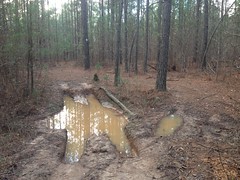
It got the job done, but it was just mud hole after mud hole. Tons of fun on a 4-wheeler, I'm sure. Kind of a drag on the bike.
Where it picked up the old railbed, I noticed a sign for The Great Eastern Trail nailed to a tree there.
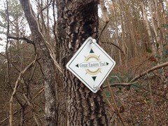
What the heck is The Great Eastern Trail? It turns out that it's a thing. Somehow I'd never heard of it. Funny what you can stumble into. Another day though, I had places to go and things to do.
The Pinhoti went the other way and I followed it as far as Starling Mill Road before picking up my originally planned route.
The road I took changes names a few times. It starts off as Poplar Springs Road, becomes Silver Hill Road, and then I don't remember after that, but it follows Taylors Ridge to the east. I think it leads up over Tightsqueeze Gap, but I might be mistaking that for a different gap.
At any rate, that's the road I took north. For some reason, I had decided that it was unpaved when I drew it on my map. Probably because the USGS quad from the '50's showed it as unpaved. It turned out to be paved, which was somewhat disappointing, as it was 8 miles long, or more.
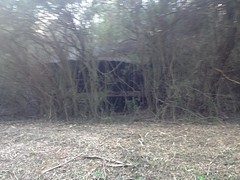
There were some interesting ruins along the road though.
And a guy and his wife were out looking for their dog and asked me if I'd seen him, which, sadly, I hadn't.
And as the sun got lower, I really started to enjoy looking at the sky.
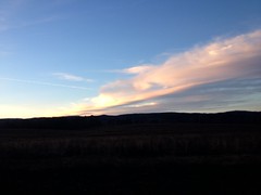
It's funny, that photo looks nice to me now, but I remember being disappointed at how it didn't really capture what it looked like in person. I wish I could recall what it actually looked like now.
The temperature was around freezing, and I was a bit underdressed. Not badly, but enough to be like "Hmm, I should have worn the other gloves."
I stopped at the gas station at Hwy 100 to hit the restroom. Johnny and Norma and I had stopped at the same gas station during or TNGA ride way back. We'd spent the night at the Summerville Motel next door too.
Ahh... memories.
I continued north and it got dark about 4 miles later. On the road, I didn't need the headlamp. The little commuter lights were sufficient until I hit gravel in The Narrows.
It seemed substantially colder up there, and even after getting onto the Pinhoti and climbing tough singletrack for a while, I still needed to stop and put on my jacket.
The trail was more difficult than I expected it to be. I don't know whether it had just been too long since I'd last ridden at night, or what, but I was fumbling all over the place and it was terrible. I actually got off and pushed the last hundred yards or so up to Hammond Gap.
I needed to adjust the position of the headlamp, so I took off my helmet, only to find the power switch blinking red. Come on! I used to get 11 hours out of that lamp on its lowest setting, and like 3 on high. How could it be low already?
This was a serious problem. It was going to take hours and hours to ride the Pinhoti back, even just halfway, and I was certain I didn't have enough light for that. In fact, there was no telling how much light I had left. Maybe less than an hour.
Grrrr.
After consulting the map and deliberating with myself for a while, the only solution that would guarantee I'd be home by midnight was a direct abort - just turning around and riding directly back down the same road I'd ridden in on.
That's what I did.
God, it was miserable. Not because it was steep or difficult, but because I'd literally just ridden that road north, all 16 miles of it, purely as a means to the end of riding the Pinhoti back south. At least on the way north I hadn't known whether the southern end of it was paved. At that point, I knew that it wasn't.
Blah!!
Nothing to be done though, but knock it out. And I did, and it didn't take all that long. It did get a bit colder though. It was 22 when I got back to the car. 22 at night seems a bit colder than 22 during the day. Fortunately, except for my gloves, I was mostly good. My left shoe was still a little damp from Chimney Mountain, so my left foot got cold, but that was all.
I really enjoyed the heater on the way home. I distinctly remember that. I think I stopped in Rome for something to eat too. Zaxby's, I think, but I can't really remember now.
So, that was that ride. Just weird. Not much else. It's fun to have those though, so I guess I'm glad that I was able to.


No comments:
Post a Comment