I can't get enough of that Pine Log. There's cool stuff out there, and by last Sunday at least, I hadn't seen it all yet.
So, I headed up there again last Sunday.
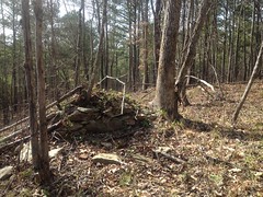
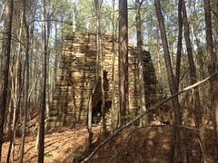
First stop, the Union Iron Blast Furnace.
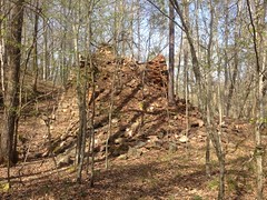
What a wreck!
This furnace lies just up the hill behind the game check station. You can easily walk to it from the parking lot, if you know where it is. I'd bet, that in the winter you could even see it from the road, if you know where to look.
The furnace was built in 1852 as the "Union Furnace", but changed hands and names many times, and was apparently renamed over and over. It was known at various times as the Union, Withers, Ford, Fire-Eater, Diamond, and Ward Furnace.
I like Fire-Eater, personally. I don't think I'd have changed the name after that.
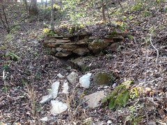
Ore was dumped in the top of the furnace, probably from this side.
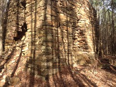
Air was blasted in through the tuyere arch on the right (east) side by a set of bellows, powered by a waterwheel. The waterwheel and bellows were actually located about well away from the furnace itself, down on the creek below, and air was piped up to the furnace via a 50 foot long pipe. Molten iron flowed out of the casting arch on the front (south) side. Slag also flowed out of the casting arch, presumably to the right of the molten iron.
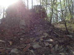
Extensive slag heaps lie to the right (east) of the furnace.
Something was mounted in front of, and to the right of the furnace.
No idea what.
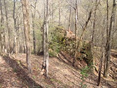
The hillside to the south of the furnace is terraced. At first this was a little confusing. It looked like a bunch of old roads to nowhere. There's a leveled area with what might be chimney ruin to the southeast of the furnace too.
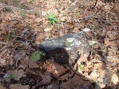
There are a few bits of ore here and there, in front of the furnace.
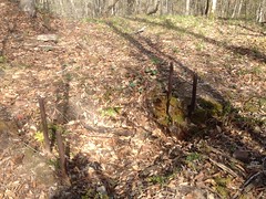
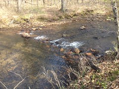
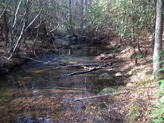
Vague remains of the rock-armored outflow for the waterwheel lie downhill to the right of the furnace, near the creek.
Even more vague remains of what might have been the mill race still line the west side of Stamp Creek, upstream, in line with the outflow.
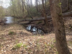
There's a small dam in the creek too, but I don't think it's related to the furnace. It's probably just there to make pool for fishing.
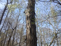
There's a shagbark hickory growing behind the furnace.
And there are trilliums everywhere.
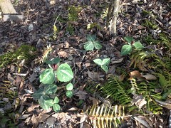
I saw a huge patch of them growing along the road too.
All right, Union Furnace!
I forgot to mention that I was on the mountain bike. I was on the mountain bike. I'd left it down by the game check station to explore the furnace, but I ran back down, grabbed it, and headed up the Main Road. It's funny, almost every time I've been riding in or out so far, there's been a car or a truck or a jeep coming up behind me. But, the road is hilly and rough, and a little challenging in a vehicle, so I push it and see if I can stay ahead of them. So, far I've always been able to.
Ha ha!
The last time I was up there I tried to find the New Stack furnace on Guthrie Creek, but I'd ended up on a road that parallels the road to the furnace, rather than the furnace road proper. This time, I knew exactly where the furnace road should be, so I made a concerted effort to find it.
At the intersection with Guthrie Creek Road, it looks like nothing at all, just some random briars. It doesn't help that the entire area was clear cut, replanted with pine, and is now criss-crossed with strip-cuts. The intersection just looks like an old strip cut. And, in fact, there is an old strip cut heading due south at the intersection. Knowing where it had to be though, I was able to discern the old road. Or, so I thought. It looked old-roadish, and it was heading in the right direction, at least.
I carried my bike by the down tube, with the seat hooked on my shoulder almost the entire time. Riding was impossible. There was too much overgrowth to even push.
Eventually the road really started looking like a 150+ year old abandoned artery.
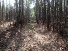
One-wagon wide. Deep below grade. I felt like I was on the right track.
And, ba-bam! New Stack Furnace!
This furnace was built in 1863 as the Thomas and Brown New Stack Furance, owned by John D. Thomas and James R. Brown.
It's not quite the heap that the Union Furnace is, but it's still a bit of a wreck.
It was also really, really overgrown, and tough to explore.
The creek to the west probably provided power.
These rocks don't look like anything in the photo, but in real life they looked like they might be part of the mill race.
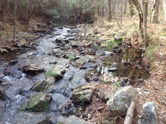
But, I couldn't really be sure.
The whole thing was rather enigmatic. Most notably, there were no slag heaps. Maybe the slag was carried off? There's another possibility though. The furnace was built in 1863, but by then, the Bessemer process for making steel from pig iron had been patented for 10+ years, and was starting to get cranked up in the US around 1865. The iron produced in Georgia wasn't (for the most part) considered high enough quality for this process. The furnace may have been obsolete shortly after it was finished. It may have been built to meet a predicted demand, which never materialized, and it might never have actually been used.
Rather than push back down that horrible road, I tried continuing along it to the west. It was less overgrown in that direction, but I still had to carry the bike. Eventually, it cleared, right at someone's property boundary. Looking at the map later, I realized that I was less than 100 yards from Guthrie Creek Road.
I backtracked to the creek though, and bushwhacked north until I hit the road. Man, it was a rough whack. Goodness. All kinds of different woods. A lot of it had been cut and regrown several times. Dirty jungle, as they say.
My right bicep was super tired from carrying the bike so far, too. Sooo tired. Apparently, it had been too long time since the last time I'd done that.
It was a steep climb up off of the creek, but I was just glad to be moving again.
From there, I rode back out to the Main Road, and took it south to the highway. Once again, a truck got behind me but I managed to stay ahead of them. Heh, heh.
At the highway, I headed east past the Stamp Creek Church, to Old Rock Quarry Road, which I then rode out to the very end. Last time I'd tried, I got off on some spur that looked like it ought to be the main road, but wasn't.
It led out to the power-line cut and crossed it. A few hundred yards into the woods on the other side I hit the WMA boundary. The trail keeps going from there, and it's not marked private at that end, but on the map it looks like it tees into the Gorman Branch Hunting Club road, which is definitely private, so I turned back there.
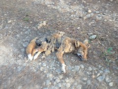
On the way out I passed by this dead coyote.
Gross.
But the weirdest thing is that I didn't remember passing it on the way in. How could I have missed it? It was in the dead middle of the road, and you could smell it from 200 yards away, in either direction. I swear, it wasn't there. Someone either dumped it, or something drug it out of the woods. But looking at it, especially all of the insects that were going to town on it, neither seemed likely. It looked like it had been lying there, undisturbed (except by bugs), for quite some time.
How could I have missed it?
I checked out a couple of side trails on the way out, but none of them went clean through to anywhere.
And, I guess that was the end of that ride.
On the way home, I stopped by the gas station owned by that Indian couple, with all of the Confederate merchandise. I amused myself imagining that if I asked him about it he would respond, deadpan, with: "the south will rise again, my friend" or something similar. Ha ha! That would be fun to hear, but I didn't have the courage, and instead I just paid for my Mellow Yellow Cherry and proceeded home.
So, there's still a good bit to explore out there. There's a vast Mill Ruin somewhere along Stamp or Guthrie Creek. I think I know where it must be. There's plenty to see at the old Sugar Hill Iron Mine on the north end too. Not to mention roads and trails galore to ride and hike. I imagine I'll be spending plenty of time in that particular WMA later this year.


No comments:
Post a Comment