Saturday, a week ago, I felt like riding Bull and Jake Mountain. Me and Iz had done some work up there the week before, and there was a work party coming up too, but I hadn't actually ridden there in a while.
All work and no play makes Jack a dull boy, and not wanting to become a dull boy, I took the opportunity.
The drive up was a nightmare. I made fine time until I got about a mile from exit 13 on Hwy 400. Then I got into some construction traffic and sat for about 30 minutes before finally getting to the exit. I got off and took Ronald Regan, only to sit another 15 minutes at the light at Hwy 20. The worst part was that I had to pee super, super bad most of that time, so it felt like a lot longer than it was.
On Bailey Waters Road, I noticed the guy ahead of me had a white and orange KTM (motorcycle) in the bed of his truck. I'd be just my luck to run into the same guy I'd seen on the trail last time. He took some slightly different route, and got to the lot just after me. Turned out it was a different guy though. This guy's bike had silver hubs and he sounded German. I gave him a heads up about the USFS looking for a bike like his though, just in case anyone gave him any trouble.
When I was dressed and ready, I realized that I'd finally used up the little packets of Chamois Butt'r I'd gotten at Mulberry Gap. Fortunately there was another guy in the lot, and he had some! He and his wife were about to leave and I just caught them. I was super lucky, and super thankful, and it was a much better day than it would have been otherwise.
Ok... On the trail...
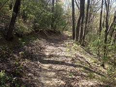
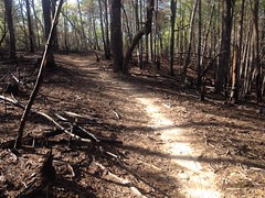
The weather was great. Conditions were great. I felt pretty strong. I chased a guy on a singlespeed most of the way up Bull, and I only caught him when he had to adjust his back wheel. He caught me again when I stopped to take this lovely photo of the lovely trail...
...and after that we rode together up to Lance Creek, where I took a little side trip up to the falls. It had rained recently, and I figured the falls would have some decent flow.
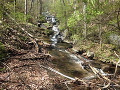
Yeah, pretty decent.
Bear Hare was a riot. I've been ripping around Blankets most Tuesday and Thursday evenings for the past few weeks, and I'd been feeling pretty good letting it go on the downhills. I'd been wondering if it would translate to the mountains, and it really seemed to.
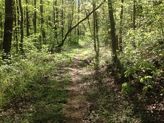
The bottom half of Bear Hare (the part that I used to think of as a road) is really getting to be a lot like Bull Mountain proper, just a ribbon of singletrack on an old road corridor. Really low down, the trees on either side have gotten tall and the brush has started to thin out, and there's an actual canopy over a lot of the trail.
I could say about the same for most of Lance Creek "Road".
I remember when I could have driven my wife's Honda up that.
It's mostly singletrack now too.
At the babyheads I'd consumed one of my bottles and couldn't remember if there was a feeder on Bull below the intersection or not. A feeder crosses there though and I wasn't sure I'd have another opportunity.
I had reservations about filling up there because that feeder crosses the trail, and I didn't have any iodine with me that day. Still though, I wasn't sure I'd have another chance, so I filled up, hoping I wouldn't need it, but figuring I'd have it just in case.
The babyhead climb was less rocky than I remember, but I still managed to sketch 4 times climbing it. So much of it is luck.
It turned out that there was a feeder downhill of the intersection, and I noticed it, but I couldn't remember why I'd even cared to look for it, didn't stop, and only remembered way later.
Goodness.
I felt good letting it go down Bull too, but the run is a bit shorter than Bear Hare, and I cut it even shorter than it could have been by turning down the Whoops.
The 3 rolling dips I'd made out of big huge rocks looked just like they had the last time I was there. I might be on to something with that strategy.
I can't remember what the name of the trail is that parallels that old road, but I took it around to FS83, took that around the bottom of Bull Mountain, and hung a left out towards the lake...
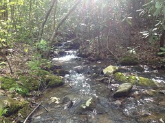
...which was a little higher than usual from the recent rain.
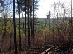
On Jones Creek Ridge, It looked like nothing had even started to grow back since the recent burn.
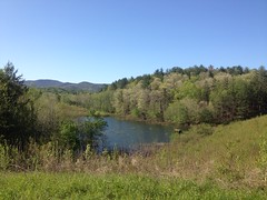
Farther on, I see across the valley, a rare thing in Georgia.
I believe that ridge is the one that you climb on the way up to the intersection below Bull Mountain proper, which is out-of-frame to the right.
On the switchbacks, I ran into a friendly couple on horseback. I thought that I recognized the guy, but I don't know where from. Maybe from one of the work parties, or maybe I'd just seen him up there before. They were headed back and were a little surprised that I was still headed out.
At 77A I should have crossed over and taken the Turner Creek Trail up to 28A, but my mind wasn't functioning at 100% capacity and it didn't occur to me to do. Instead, I took the road...
...and only realized what I could have done after turning on to 28A and passing the trail on my right.
Ha!
I still felt strong climbing No-Tell.
Also, I noticed various ribbons...
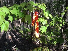
...and arrows...
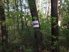
...in the vicinity. No idea what they were for. The Fools Gold isn't for another few months. The Rangers may have been up to something.
I started getting tired on Black Branch, and by the time I finished climbing up to the north end of Jake I was ready to be done.
Fortunately, it's mostly downhill to Jones Creek.
I did stop to get a photo of the bad spot on Jake.
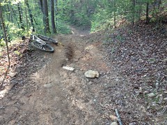
It's not so bad that we can't fix it, if we get to it soon. In the early 2000's, that hill had a 2 foot deep trench in it, top to bottom. I think it was in 2007 that JK did all the machine work to fix it, just before they started work on the reroutes. He put in a deep rolling dip at that spot, but it's gotten backfilled and worn down since then. Not a bad run though - 11 years. The rest of the hill still looks fine. I'd like to rebuild that dip out of rock like we did on the Whoops and see how it performs.
Jones Creek was super high.
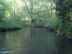
Here I am, crossing it.
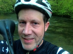
I felt like I was smiling when I took that, but I guess not!
That might be a grimace, or something similar. I was pretty tired at that point.
I couldn't quite keep the bike out of the creek either, and it kept pulling whichever wheel was deeper downstream and trying to twist it off of my shoulder. I was worried that I was going to drop it and have to go swimming after it.
Ha!
Adventure!
The climb up to the lot wasn't miserable, exactly, but it was tough.
Near the lot, there was a tree down too, at about a 20 degree angle to the trail. The final challenge! It was small enough to hop, but the angle made it impossible.
Fail!
I failed the final challenge.
There were about 15 cars in the lot when I left, and the lot was completely empty when I got back.
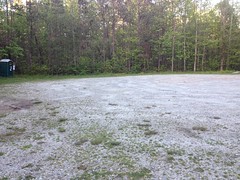
Ha! I outlasted everyone, even the guys that were getting ready when I left!
Man, I was tired though. So tired.
I ate at El Jinete in Dawsonville on the way back. Good old Chile Colorado.
I don't remember much else about that day, so that must have been all that happened. I've got to start writing sooner.


David, the arrows/ribbons were from the Ranger trail/mtb race on 4/28 https://runsignup.com/Race/GA/Dahlonega/MountainRanger5k15kRun34kMountainBikeEvent
ReplyDeleteAhh, yes. That makes sense. Back when I was racing I always wanted to do that one, but kept missing the date. Maybe next year...
ReplyDeleteThanks so much for the great information both here and on your trail site that help me understand where I live a little bit better
DeleteMy pleasure!
Delete