The whole Blanket's Creek - Old Rope Mill area was once part of the Little River WMA. I'm not exactly sure how far it used to extend, and I haven't gone looking for maps of it, but the ArcGIS topo quads still show it, and I'm sure older quads of the area do too. Part of it was on Army Corps land, and part was owned by the city/county/state. Eventually the DNR gave up the WMA and whoever owned it started building neighborhoods. If you go exploring around Toonigh Creek Falls, you can find an old I-beam and wire gate, as well as some old signage.
With the covids keeping everyone at home these days, some buddies of mine started exploring some of the lands south of Olde Rope Mill, rather than riding all over creation, as they were previously wont to do. I'm guessing that this stuff used to be part of that WMA. Hard to say without more research, but that's not super relevent, except re. the title of this post. I could kind-of tell where they were riding from eyeballing their Strava routes, and I love exploring and finding stuff, so last weekend I headed up that way, looking for Adventure.
It took me a while to find Tin Can Alley - the trail that connects Olde Rope Mill to everything south of there, but I found it eventually. It generally led over to the Park 9 apartments...

...which had various out-of-place feeling gravel roads running around it.
This must be the place!
Oh yeah!

Definitely the right place!
Trails and old roadbeds everywhere. Everywhere!
And, a lot of them led to, across, or along Noonday Creek or feeders of it.

Glorious.
Well, almost glorious. It was a spiderweb to be sure, and I get a little obsessive when it comes to exploring crap, like following overgrown stuff that people don't hike or ride any more, all the way to the end. This sometimes leads to interesting discoveries, especially in areas where the roads aren't just an old logging network. But, not this time. I mostly just found tons of super steep climbing on super eroded old roadbeds. There were plenty of good trails though, and I did have an overall good time.
At some point, I tried hopping a downed tree that was a little bigger around than what I typically hop. I made it over, but apparently my bars were a little loose, and when my front wheel hit, the pressure on the flat parts of the Ergons twisted them toward me.

It takes freaking forever to get Ergons set right, and I must have stopped to readjust the bars like 10 times over the next few miles.
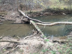
Down by Noonday Creek, there was this cool log-bridge thing.
The climb up off of the creek there was just sadistic. There were 2 big kicks. I made the first one, but it was almost too steep. Like, I had the bars pulled so close to my chest, that if they'd been any higher, I wouldn't have been able to make it. The second kick... forget about it. It wasn't as steep, but the trail was like 8 inches wide with a big rut to the right. One wrong move... I ended up riding it twice, and just rode off into the rut both times.
The trail beyond led to a golf course, eventually.

...but it was mostly just an out and back.
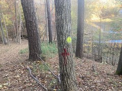
Back at the top of that sadistic climb, there was a network of trails in both directions, marked by yellow dots, blue lines, and red crosses.
This took forever to explore, and mainly looked like lake access to the various neighborhoods.


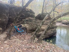
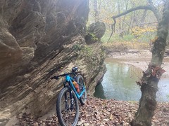
There are a bunch of big, cool rocks on Noonday Creek.
...and some interesting materials along the various trails.

The fall colors were in full-pop.
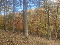
...and the leaves were actively falling everywhere.

Awesome.
What was way less awesome, though, was that the Strava app had randomly decided to stop recording some time earlier. I'd lost almost all of the ride. I just happened to notice that it wasn't running while taking a photo.
Goodness.
Traditionally, I'd have the GPS and strava going at the same time, but I never re-mounted it on my new bike, so I've been flying solo for a while now. And, foolishly, it turns out.
"Fortunately" I had to re-ride much of what I'd ridden earlier to get out, so I managed to get some of it. The rest I had to piece together from GPS locations of photos, and old maps, which did, in fact, show some of the old roads I rode.
I made it out of the woods right at dark, after getting slightly lost. I actually pushed out up an old overgrown bit that came out in those apartments I mentioned earlier. As I emerged from the woods, a lady and her like 3-year-old daughter were walking by. Can you imagine, as a mom, how freaked out you would be, if an extremely dirty guy emerged from dark woods, in the dark, right as you walked by. I figured it would be better to actually emerge, than to stop and wait for them to go by, as they undoubtedly had heard me trapsing around well before I was them, and it would be even scarier if I seemed to be hiding, especially if they'd already caught brief sight of me. I said the friendliest hello that I could, and waved, and all that, and it seemed to put them at some amount of ease. Also, I'm sure it started making sense when they saw my helmet and bike and gear. The little girl was totally at ease, at least, because she said hello back and just started talking to me. They were playing hide-and-seek with her brother and dad, apparently! No chance you'll ever read this kid and mom, but if you somehow manage to, I'm sorry if I scared you.
And that was about it. I was on Riverwalk Parkway, so I rode back to the car that way.
Dinner was a Big Kahuna Chicken Sandwich at Canyon. Love it so much.
Looking at GPS data later, it looked like I only explored about 60% of what's out there.
I'll be back.


No comments:
Post a Comment