I made a resolution, last year, to hike more. The bike is great and all, but the medium impact of hiking seems to be good for my joints. I feel more like an old man getting up off the couch when I haven't been hiking a lot, and I've really started to notice it over the past few years.
As resolutions typically go though, it was difficult to stick to. Illness and travel didn't help. But this past Sunday, I did make it up to the Cooper Gap Area to check out some trails that I'd been meaning to explore for a while.
I'd explored the same area on my last 2 hikes, but while crunching the GPS data, I noticed a road that I'd missed in the lidar data. Can't let that go unexplored...
I parked at Cooper Gap, said hi to an AT thru-hiker that was setting up camp, headed east a bit, then dropped down over the edge into the cove below. I found the road I was looking for almost immediately.
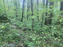
It's right there, can't you see it?
Jokes aside, it was super, super overgrown, and semi-difficult to follow. I did follow it though, and uphill it ended after maybe 100 yards. It looked like it legitimately ended there too. Like it always had, and not like it ever made it all the way up to present-day FS42.
Logging road?
Probably. I'd sure love to meet someone with definitive knowledge though
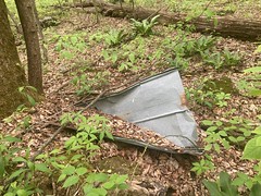
I followed it down, and discovered two interesting things along the way.
Some tornado-flung roofing was lying a bit west of the trail.
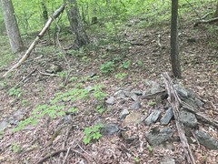
There were several piles of "organized rocks" a ways down too.
The trail eventually just became another trail that I'd already explored. When I'd last been out there, I hadn't noticed that it continued because of how flat it was at that spot, and because of a tangle of downed trees.
I kept going down and down and down, and eventually picked up another old roadbed that I hadn't explored yet. It was much like Old Cooper Gap Road - worn in very deeply below grade in a lot of places. Like Old Cooper Gap Road, it struck me less as having been built for logging, and more as having just been the way people went up the mountain, which had clearly been rerouted many, many times over the years.
Eventually that old roadbed bent around and teed in to Old Cooper Gap Road, which just made that theory more credible. But really, if you follow it up the mountain, it doesn't go anywhere. I just ends, abruptly, short of the gap, in very steep terrain. So, IDK. Maybe there was an original route, followed by some reroutes, followed eventually by the modern road, and then the original routes were used for logging, spurs were cut off of them and eventually abandoned, but continued to get recreational use for some time, causing them to get worn in below grade, until they eventually became inaccessible or impassible and finally overgrown. I don't love explanations like that though, as they require a lot of assumptions, but that does fit with the evidence.
Again, maybe someday I'll run into someone who knows for sure.
Down near the bottom end, the road sat on a ridge that dropped down pretty steeply to some feeder of Ward Creek.
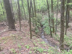
It was actually pretty spectacular in real life, but was difficult to get a representative photo of.
I managed to find a bearing tree...
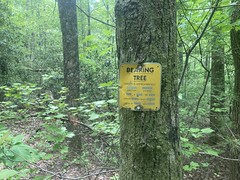
...and an NF boundary marker down at the bottom end too.
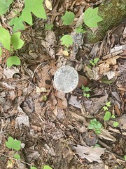
Pure luck that I saw them too, as they were both pretty well obscured behind some deadfall.
Speaking of which, "obscured behind some deadfall" would be a good description of everything down there. This was pretty typical:
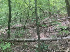
I climbed over, under, and around that kind of thing, most of the day.
I actually recognized where I was when the trail teed into Old Cooper Gap Road, and since I didn't have the motivation to backtrack and explore every little spur that I'd marked on the way down, I just took it back up to the gap.
About halfway up I got a call from Sophie's friend Madi, but the call quality was so bad that neither of us could understand each other. It worried me a bit though. Why was Madi calling me? The last time that happened, Sophie was super sick. Then I got a call from Sophie. Again, we couldn't understand each other. I climbed and climbed, hoping to get better reception. Eventually I did, got a call from Madi again, and this time we could understand each other. Sophie was at the Renaissance Fair with Madi and others, but had no 5G service, and she wanted to know if I could check her bank account to see if she had enough money to but some stuff. Madi's phone just worked better than hers.
Ha!
By then I had decent service. Yes, she had plenty of money.
Man, this connected world we live in. I can be deep in the woods and check my kid's bank account.
On the way up to the gap, I found this lonely Wild Azalea.
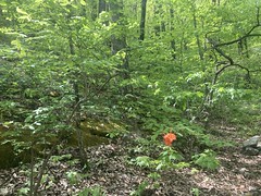

I'd seen a few on the way down, but they were all pretty far away. It was great to see one up close.
At the gap, there was a different AT thru-hiker in the campsite. The first guy looked like he was stopping for a while, but I guess it had been a while, and he had gotten moving again. This guy also looked like he was stopping for a while, but I couldn't be sure.
From there, I followed a trail north. This was another trail that I'd seen on lidar data, and had marked on my map, years ago, but never actually checked out. Just finally getting around to it. I suspected that it had been the original route of FS15, as it appeared to just bomb down from the gap and tee into FS15. What would I find though?
Well, the upper half of it was very well worn. Various fire rings indicated that AT hikers camp down there at times. Past the last fire ring, it got overgrown though, and there was deadfall here and there. It was a proper old roadbed though, probably 20 feet wide at points. It was a good bench cut too, and didn't show any immediate signs of unstainable wear. If it was a former route, why had it been abandoned?
I eventually found the answer. Further down it intersected a creek, and hung a left. The creek appeared to have once flowed to the north of the road, but over time had moved such that it flowed directly down the road for several hundred yards. Below that, the road was very wide, and very below grade. So, yeah, it had become a mess, right there, and rerouting it was the best option. I have a map from 1889 (I think) though, that shows it in its current configuration. So, it made me wonder just how long ago it had been since anyone really used that section that I was on.
Climbing back up FS15, I immediately noticed a new house, right there on the road. The owners were hanging out, and I talked to them as I went by. It had apparently been a while since I'd been to that exact spot, because they'd built it about 2.5 years ago! Nice place though.
The switchback at the top of FS80 felt steep, even on foot. Many years ago, my Dad and I had rode the Canada Creek loop, and he stopped like 200 yards from the gap, then kicked himself later for not riding the final 200 yards. I did the same on a ride with Eddie and Shey a few years back. If it feels steep hiking though, it's officially steep, so I called my Dad later to tell him that.
Back at the truck, I got changed and headed back down the mountain. There was a really nice repair on FS80 near Sky Orchard.
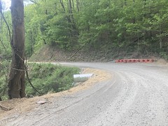
It looked really sketchy the last time I was up there. It was good to see it repaired.
I forget exactly what I did for dinner, so I guess it wasn't too important.
Good day overall though. I didn't hit it too hard and blow myself up, but it was still pretty satisfying. It did take a minute to get used to something always touching me, but that's just how it is off-trail, this time of year.
Now, I crave more of it.


No comments:
Post a Comment