But...
We'd heard you need a permit to camp anywhere in the backcountry, so Saturday morning, we stopped by the Sugarlands Welcome Center to pick one up. As it turned out, you not only need a permit, but have to make a reservation at each campsite you want to stay at. There are a couple of campsites you don't need to reserve, but only a couple. Exploring was out the window. We had to plan our route, but without knowing the terrain, that turned out to be difficult. In Georgia, I can comfortably cover 10 to 15 miles a day, but in the Smokies, the elevations are higher and the terrain is much rougher. It was hard to say how much we could do.
Ultimately, we took the conservative approach, got a reservation for that night at the Mount LeConte Shelter, came up with as plans A, B and C, and began walking.
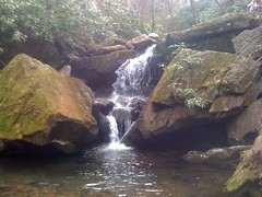
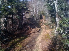
The Rainbow Falls Trail was steep and rocky, and packed with wrecked up tourists. Husbands were towing their wives up the trail. Worn-out kids were lying down on the rocks. Not an easy climb, but we made good time to the falls, which was a little anticlimactic.
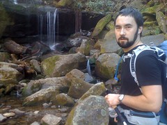
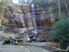
Oh, wait, never mind, that's not the actual falls. Around a few more corners, we found the real Rainbow Falls, which was, in fact, spectacular.
Fat little red squirrels were running around begging everybody for food and screaming at people that didn't give it to them.
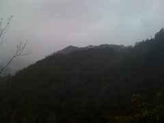
Above the falls, we didn't see another soul until we hit the top of the mountain.
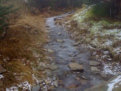
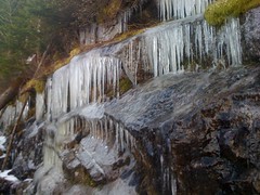
It was a bit colder up there. A light dusting of snow remained from the previous night where it had reportedly dropped to about 16 degrees.
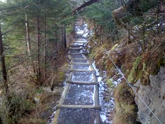
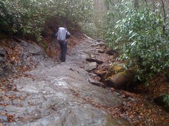
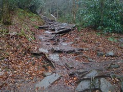
Several sections of trail were glacial.
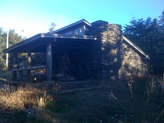
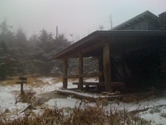
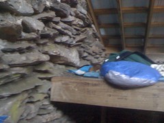
When it flattened out, we started looking for the shelter. We saw some buildings...
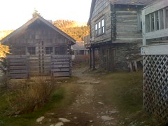
What the heck? Was this the shelter? Ohhhh, wait, now I remember...
Months ago my brother and I hiked up to Springer Mountain from Amicalola and on the way back, we stopped by the Hike-Inn. Whilst a-setten down on their front porch, some folks mentioned that they'd stayed at a lodge up on Mount LeConte as well. When I saw LeConte on the map, it rung a bell, but I couldn't remember why. Standing there, it all came back to me. This was that lodge.
It appeared to be closed for the winter, but at least the privy was open.
Up the trail a bit, we found the actual shelter...
...then made a quick trip up to High Top...
...and a quick loop around the Cliff Tops. You can't see the cliffs, but the views were nice.
We'd walked maybe 7 miles, but climbed over 4000 feet, and about a third of that was above 5000. Those 7 miles were tougher than any 10 in Georgia. I was happy to call it a day.
There were a couple of folks already at the shelter when we got there and more arrived shortly. Within an hour, there were 12 of us, the shelter's maximum capacity. We cooked, ate and talked. It was a good group. Everybody was friendly. No weirdos.
The top of LeConte is covered in Frasier Fir, but a lot of it had been decimated by blight. Apparently, despite the abundance of deadfall, people had been cutting limbs off of the live fir trees for firewood. Naughty, naughty. So, fires are now prohibited and the shelter's chimney is walled up. But, of course, where there are rules, there are rule-breakers and some of the guys built a fire on a pile of rocks outside of the shelter anyway. Fortunately, they didn't cut any of the live trees, so, eh. Maybe it was OK.
Me and Kirk had no interest in the fire and just sacked out. Ten minutes later a bear came by, poking around for food. It tried approaching the shelter from a bunch of different directions, but whenever it would realize that we could see it, it would slink back into the woods. Sneaky bear. It wasn't interested in us, just our leftovers, and eventually I guess it realized we weren't going anywhere and gave up.
It froze that night, but it was warm in the shelter, and despite 12 people snoring 12 different snores on top of each other, I slept pretty well.
The next day we headed down the Trillium Gap Trail. Trillium Gap is open to horses and has some interesting structures to help the horses get over the rocks.
It was cold.
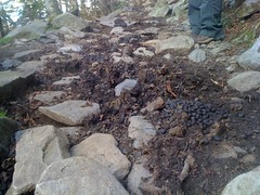
We kept seeing weird tracks. They kind of looked like big deer tracks. Were they elk prints? There are elk in the Cataloochee valley, maybe there are elk here too. Later we learned that they were llama tracks. They use llamas to resupply the lodge.
Apparently, llamas like to poo together. Every couple of miles, short sections of the trail were inundated, but there was little or no poo between them.
Grotto Falls was cool. You walk behind it.
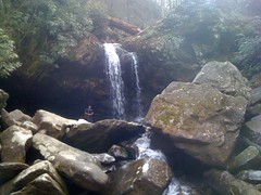
We stopped for lunch there. I had mashed potatoes. My pot was dirty, so they tasted a lot like the chicken noodles I'd had the night before.
There was a little cascade down below Grotto Falls proper. It wasn't all that awesome, but we still risked life and limb to get a good look at.
We'd planned on taking the car back to Sugarlands and reserving another shelter. Exactly which shelter... we weren't sure, it would depend on what time it was. When we got there, the reservation office was closed. They did give us a number to call, but we had to drive back into town to call it.
When we got back to town, we realized that it would be dark before we got to the nearest campsite. Neither of us felt like walking in the dark, so we bailed on that plan and got another room at the HoJo. It was like 4 o'clock though, so we milled around Gatlinburg, went to the aquarium and grabbed some dinner at the Hard Rock Cafe. I usually like to check out the local flavor, but in Gatlinburg that's pretty much just pancakes, so the Hard Rock would have to do. It also helped that it was the closest restaurant to our hotel.
The next morning was cold and rainy. It kept threatening to let up, but never actually did. I'd called the reservation office the night before and reserved the LeConte shelter again. We planned on putting one car at Newfound Gap, taking the other to Alum Creek, hiking up the Alum Cave Creek Trail, staying at the shelter, and hiking down the Boulevard the next day. If we were feeling good, we'd camp at one of the sites near Newfound and do an out-and-back on Chimney Tops on Wednesday.
But, first things first; we were hungry. On Saturday, there was a line out the door of the Pancake Pantry, running halfway down the block, so we passed, but that day, there was no line, so we gave it a try. I'm not sure I'd stand in line, but it was really good. If you're in Gatlinburg on a weekday, you should eat there.
At Alum Cave Creek it was still raining. Not super hard, but if I'd been at home, I'd have stayed inside.
The trail started off pretty shallow, but after a mile, it kicked right up.
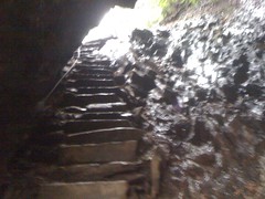
There's a cool rock arch that you pass through...
...with stairs.
The rain had eased up, but the wind got stronger and stronger, and we were soaked to the bone anyway. My feet were even wet, inside my waterproof shoes.
Duck Hawk Ridge was visible from an outcropping just around the end of Peregrine Peak. There are 2 holes in the rock along the top of the ridge, one round and one square. They look great in real life. You can sort of see them in this shot.
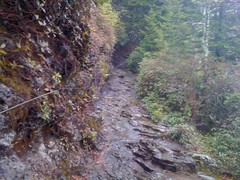
The trail got pretty gnarly after that. There were a bunch of sections that were just narrow, rocky ledges. If they'd have been icy, they'd have been dangerous, and we'd have needed to hold on to the cables or die. Fortunately they were just wet, but the temperature was dropping.
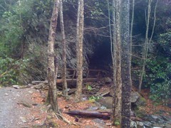
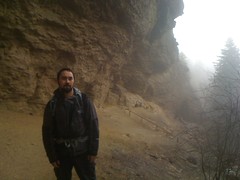
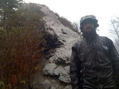
Up the trail a bit, we found the Alum Cave itself. It's apparently an old mine. They mined the cliff face for salt-peter or something, then later more of it just eroded away. Now it's a big, dusty overhang, and that day, it provided welcome shelter from the elements.
We hung out for a while, but the temperature was dropping and as wet as we were, we needed to keep moving.
When we reached the shelter, it was snowing, and the wind was just killing us.
I put on dry clothes, but they didn't help. The temperature was coming down, and even in my bag I was getting really cold. Kirk was still wearing all of his gear and looked pretty warm. Maybe not perfectly comfortable, but warm. I'd always heard it's better to get your wet clothes off, but I'd also heard that many fabrics can still keep you pretty warm, even when they're wet. For a while, I debated what to do, but finally I put my wet jacket, socks and shoes back on, did a bunch of jumping jacks, ate some hot food, and crawled back from the edge of hypothermia. When I felt like I wasn't going to actually die, I found a nail in the corner of the shelter and one-by-one, I hung each article of wet clothing over my camp stove, dried it out, and put it back on. After an hour of this, I was dry enough to get back in my bag, and after a while, I even felt warm.
Halfway through my ordeal, another hiker showed up and got comfortable at the other end of the shelter. He had a lot more gear than we did and a much warmer bag. I'm not sure he was ever even cold :)
Just as I was getting comfortable, the caretaker from the lodge came by and invited us over to his place for some hot chocolate. A few minutes later, we walked over to the lodge and no doubt, there were oil lamps burning in the kitchen and a pot of hot chocolate on the stove. It was the exact definition of cozy. We sat, drank and talked. That's when we found out about the llamas. We also found out that three of the spots we thought were campsites, were just points of interest. You can't camp there, at least not legally.
Oh yeah, one funny thing... When we walked in, there was a book sitting on the table: Unsolved Disappearances in the Great Smoky Mountains. For a second, I wondered if we had walked into some kind of trap, but then I thought of all the reasons why it couldn't be. The park authorities knew where we were, and who was at the lodge, there were frozen footprints everywhere that wouldn't thaw out for days. At first it was fun to think about, but then I felt guilty about being so suspicious.
Before it got totally dark, we reluctantly walked back to the shelter and dug in for the night. Heat rises, so we slept in the top bunk, but man, it was drafty up there. I was dry though, and for about an hour I was warm. After that, as long as I laid in the right position, I wasn't exactly cold, but I wouldn't call it warm either. I kept waking up with sore joints, rolling over and trying to find another position to lie in. I don't think it was the most miserable night I ever spent in the woods, but I can't specifically remember one that was worse.
The next morning, the sun was out and it was much warmer. We got up and ran by the lodge for some more hot chocolate. Apparently it had gotten down to 15 degrees that night and the caretaker was surprised that we didn't come over to the lodge and try to bum a room off of him.
When we got back to the shelter, a little red squirrel was running around, tearing stuff up and begging for food. He was cute. Kirk gave him a snickers.
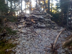
We didn't waste time getting back on the trail. At High Top, we dropped a couple of our own stones on the pile. When the pile tops 50 feet, LeConte will be the highest mountain in the park.
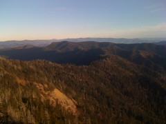
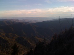
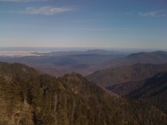
At first, the Boulevard was icy and treacherous, but when we got down off of LeConte it was nice. Warm even. Some sections ran directly along narrow ridges, with steep drops to either side...
...and there were stunning views.
The climb up Mount Kephart was rough, but other than that, it was an easy walk out to Newfound Gap.
None of our camping plans had panned out. It was too late to drive into town, reserve a shelter, drive back up and hike back out.
Back to the HoJo.
Back to the Hard Rock.
Being out in nature makes me appreciate nature, but it also makes me REALLY appreciate civilization. After a cold night in the woods, I don't take it for granted when I can just turn a knob on the heater and make the entire room the exact temperature I want.
The next day it was raining again, this time even harder than before. We had one last mission though, Chimney Tops, and the rain would not stand in our way.
We checked out, ran by the Pancake Pantry and drove up to the trailhead.
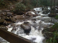
The creeks were a little high.
The trail was steep and chunky. The rain and wind were relentless.
Near the top, it shallowed out and stopped abruptly at an impressive little peak.
I climbed about halfway up, but the wind was whipping, the rain had turned to sleet, and I am no mountaineer. If it had been a calm day, or if it hadn't been sleeting, it would have been a different story, but in those conditions, I was not confident that I could make it to the top.
We trucked it back down. The rain was letting up, but the creeks were much higher. MUCH higher. Every little mountain stream looked like the Tallulah River. I should have taken some photos.
And just like that, it was done. Our great adventure was at an end. We drove back to Atlanta, grabbed some dinner in Cumming and Kirk kept going on to Birmingham. The whole thing is still fresh in my mind, and being home actually seems weird. But that's cool, it just means that I have some new perspective, and that's usually a good thing.
In a couple of ways, the trip was very successful. Kirk is always good, stress-free company. I had a great time just hanging out with him. We saw some amazing stuff. My body (most importantly my knees) held up well. My Murmur pack worked great, though the way it closes is awkward. Most of my clothes worked well. I learned some valuable lessons about how to stay warm and how much food to bring. There are probably some other things too, I just can't remember them offhand.
On the down side, I need some new shoes. My waterproof trail running shoes are most definitely not waterproof, and the cramped toe box put bleeding blisters on both pinky toes. Also, if I plan on going out in colder weather than that, I'll be needing a lower-temperature bag, or at least bring my bag liner, or something. I've got some work to do there.
I noticed some interesting things about the trails too. Of the hundreds of water bars out there, almost every one of them was functioning perfectly, and not one of them looked like it had been maintained in years. I've seen so many useless, backfilled water bars, that I've pretty much become a crusader against them, but apparently my opinion could use some revision. In the smokies, they work fine. I suspect it's because on nearly every trail, the top soil is either super-compact from all of the tourist traffic, or completely worn away, and the remaining surface is either solid rock, or a veritable asphalt of little one-inch diameter, flat stones. In any case, at this point, the trail surface is so hard and sheds so little sediment, that it would take forever to overwhelm a water bar. In fact, even during hard rain, which we saw plenty of, the water running down the trail was completely clear. Even the horse trails are immaculate. The showed none of the characteristic horse-wear I've seen in Georgia. I was also surprised how few spur trails and old logging roads there were. In Georgia, there are 10 miles of overgrown logging roads for every mile of trail, but around LeConte, I saw very little but the trails themselves. Are the old roads that well reclaimed, or were there never any to begin with? I'm curious.
I want to take my road bike up there some day and ride from Cherokee to Gatlinburg, grab some lunch and ride back. If that's legal, it would be epic. If I dare to dream, maybe someday there might even be mountain bike trails up there. Maybe someday. For now, I'm just happy to have hiked it, and I can't wait to go back and see the rest of the park.


Found your blog when I was researching Trillium Gap Trail. Will be hiking it this fall. Tackled Alum last fall. CLIMB Works has some mountain bike trails. On your next visit, you should check out Ramsey Cascades in the Greenbrier section & Mt. Cammerer Fire Tower in Cosby to see some different sections of the park. To bad you didn't stumble on any of the great local restaurants.
ReplyDeleteEnjoyed your post.