When Sophie finally woke me up, the Upper Chattahoochee Loop was the first thing that came to mind. I drove around up there last week and realized there's some of stuff I haven't explored yet.
Exploring!
It's definitely fall in North Georgia...
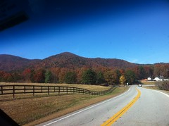
Like a photography exhibit of rural mountain landscapes, all the way to Helen.
I parked at the "No Camping Here" lot. The gate on FS178 was open and there were "Caution: Trucks Entering Road" signs nearby. I've never seen a logging operation active on a weekend, but I made a mental noteto be careful if I ended up coming down that way later.
I tweaked on my fork for a few minutes and started climbing 44. I had about 8 pounds of crap in my camelback. This past race season, I've kept my body weight down and joked that if you can't be strong, the next best thing is light. Maybe this year I can be strong AND light.
First I checked out a little trail leading up a knob, probably to an old campsite. There were a ton of beer and Sprite cans up there. Too many to pack out. There was no fire ring though and the river cane was all up there, taking the power back.
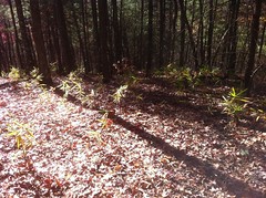
It seems like river cane suddenly started growing everywhere last year.
The campground on 44A was closed...
... and there were signs about the Upper Chattahoochee Watershed Restoration Project.
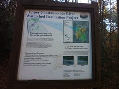
I saw some evidence of that last project week. Here, they'd overhauled the campsites - gravel tent pads, fire rings and picnic tables.
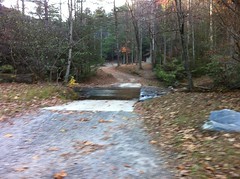
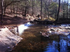
There are two fords on 44A, the second has a neat little waterfallish thing running off the edge.
Past the second ford, the road looked like it was closed more often than not; it wasn't soft, but there was a thin layer of leafy-needly stuff. I was climbing fast enough to heft the grade, fast enough to feel washed by the breeze, but easily enough to stay relaxed, listening to the little heart-drum thumping in my head, catching views of painted ridges, feeling connected with the mountain, and feeling like I was a long way from the next person. That particular experience is unique to mountain biking. It's one of my favorite things in the world, especially when it sneaks up on me. It's making me smile right now, thinking about it.
At the first food plot, I trudged out on a side trail that led over to another food plot, then wound around the contour before dropping off percipitously like the foreman's suicidal brother in-law had gotten drunk and borrowed the bulldozer for one last joyride. Eventually I thought of a more mundane explanation, but the drunk brother-in-law theory was fun while it lasted.
Back on 44A, I dove down to England Camp Branch, launching over endless rolling dips, crossed the creek and climbed up to another food plot. Legend has it there was an apple orchard there once, but the apples are gone now.
On the last kick up to the plot, I stopped to check the map and a black bear ran across the road about 100 yards up. The whole Upper Chattohoochee is big-time bear country, and I'd pretty much expected to see one when I started riding, but that didn't make it any less cool when I actually did. The bear stopped too and turned his head toward me, but there was a tree between me and his face. He couldn't actually see me and he seemed a little confused. I thought about digging out my phone to take a photo, but I didn't want to give him too much time to decide whether he should keep moving or not, so I was all: "Yo bear, you can keep moving, I'm not coming after you" and he carried on.
Ages ago, I'd heard tale that 44A eventually tees into Jasus Creek Road. The USFS GIS data shows it ending at the old apple orchard, but there are plenty of errors in that data, maybe that was an error too. I pushed all the way around the perimeter and found the continuation of the road, but there was a Wilderness Boundary sign posted there. No bikes in the Wilderness. Man, it'll be a long walk, but I'll have to come back one day on foot. I knew the wilderness boundary was up there somewhere, but I wasn't sure exactly where. I used to have the boundaries of all the roadless areas (including wilderness) on my trails site, but the site I was getting the data from recently took down their tile server. I did find public GIS data for every US wilderness area during that coding binge I mentioned earlier though, so I'll be dumping that in soon.
Further around the perimeter, I noticed a slight clearing and a black nylon strap wrapped around a tree. That's odd... Lying nearby was a grey box. Wow, a camera trap! I've seen these on TV, but never in real life. It appeared to have been ripped violently off the tree and landed face down in the pine needles. Maybe that bear I saw earlier knocked it off. The hangers were broken off of the back, but it was still working. I placed it at the foot of the tree.
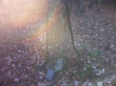
It had a semi-good view of food plot. Maybe the Forest Service put it there to study who's using the food plot. Maybe somebody put it there looking for big foot. Monsterquest!
My front tire was flat. There were no fewer than 4 thorns in it. That's two front flats in as many rides on these tires. I don't know, that's not a promising start.
It was a grind back up off England Camp, but descending 44A was a blast. My trailhead fork tweak was working out pretty well. The new tires didn't seem as nimble as the Pythons though. When you lay it over, there's no edge, just more of the exact same grip. I had to use more force to turn, and countersteer at what seemed like lower speeds, though maybe I was actually going faster and it just felt slower because it was so stable. Hmmmm.
I skipped the Jasus Creek loop... not enough hours left in the day. At 44C I paused. The GIS data shows it as FS44C. The WMA maps show it too, but the sign was missing, the gate says Road Closed and there was a half-vandalized no-motorized vehicles sign posted next to it. Maybe they closed it as part of the restoration project but it's being maintained to access the food plots. Who knows.
A few turns in, somebody had dumped an ancient fridge.
The road was a pretty consistent grade, all the way up. All of the culverts that I noticed had stacked-stone fills around them. Was this an old railbed?
I passed another gate and eventually hit some humps. There had been Wilderness Boundary signs to the right all the way up, but there was no sign ahead. My map shows the road going all the way Poplar Stump Gap, but this had clearly been the end of the driveable section for quite some time. The Wilderness Boundary might cross the road here but I had no good way of being sure. I really wanted to see if it led up to Poplar Stump, so I stashed my bike and started walking. It quickly turned into a rhodo tunnel and got really thorny at the gap itself.
There was a campsite on the AT, but nobody was camping. The AT itself was kind of wide to the south. Looking at the map later, I wondered if maybe the road had kept going along the ridge there and eventually connected up with FS850 on the other side. I've seen a photo of a logging train taken near Low Gap. Was this the railbed for that train? The geared engines could allegedly handle 6% grades but this one was around 10% grade. Hmmm again.
I had to hustle back to the bike.
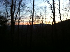
The ride down was dusky but I could still see.
Back on 44, I needed light. The road was bright and reflective but I wanted cars to be able to see me. I'd brought my little commuter light to see if it would be enough on a forest road, and struggled for a few minutes to get its ultra-powerful velcro unstuck from itself, only to then discover that it had a dead battery. Yay. Good thing I also brought my real light.
I backtracked on 44 to the truck. There were only one or two climbs. I passed a few cars. It was pretty leisurely. It was also getting cold. I had cold weather gear in my pack but I just pushed through. It wasn't that bad.
For dinner, I skipped Helen proper and went straight to the Nacoochee Tavern and Pizzeria, which I highly recommend, and had their Chicken Parmesan sandwich, which I also hightly recommend. A "half" sandwich is still a foot long. I sat at the bar, near the door, so it got cold when somebody came in, but that made the food seem even warmer and the restaurant feel even cozier.
One of my potato chips had a hole in it shaped like a heart.
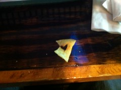
The girls really liked that photo.


No comments:
Post a Comment