Companions or not, I had a hankering for some climbing and the hankering could not go unsatisfied. It took a minute to decide where to go. I saw some blue and yellow wildflowers along the side of the road and remembered climbing Nimblewill Gap road 4 or 5 years ago and running into a mile or more of similar flowers along that road. I couldn't remember if it was spring or fall. Maybe it was spring. Thinking about that reminded me of my failed attempts to find the elusive FS665/665-2 connector. The rusty gears were turning. A plan was coming together.
I parked at Nimblewill Church and headed up the road toward the gap. The weather was cool and breezy. Some folks were out doing yard work. A teenager on a 4 wheeler passed me, then stopped up the road a bit to put a little pinch between his cheek and gum.
"Take that trail there, it's more fun." "Where does it go?" "Just up to the corner."
Yep, it went right up to the corner like he said. There were some fun little whoops at the end too.
Not far up from there I recognized a little side road that I'd seen a couple of times before and in the back of my mind, I half remembered that it should lead to a cemetery and indeed it did.
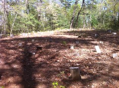
And a pretty big one too. Bigger than most middle-of-the-woods cemeteries I've seen. It was a little odd too, most of the stones were identical and unmarked.
Nimblewill Gap Road became FS28-2 and the climbing began in earnest. I did some intervals to try to kickstart something. It felt like I haven't ridden in a month. Man, I was fast and strong last year. How did this happen?
From up there, you can see distant ridges and deep valleys.
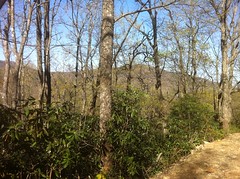
Photos just don't do it justice. From one of the turns, you can see all the way down to Dahlonega, which really just looks like more woods except for the gold steeple of North Georgia College beaming like a lighthouse. Go check it out, it's pretty cool.
When I reached Nimblewill Gap, my legs were satisfyingly dead.
I expected the descent down FS28-3 to be equally satisfying. For at least 11 years now, it's been a chunky, rutted, treacherous, jeep trail of a road. I've double flatted on it before and had to ride out to Hwy 52 on a flat rear tire. Two winters ago we rode it in the ice and snow and kept breaking through into ruts deeper than our hubs. Bring it on.
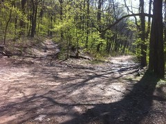
Woohooo! Ohhh. What? Somebody's been running the bulldozer up there.
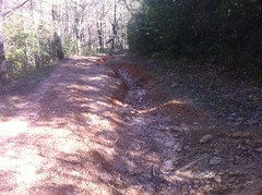
Today, FS28-3 was a beautifully clean, perfectly outsloped, model forest road. Except for a few exposed rocks, I could have driven my wife's Honda Fit down it. It looked like they cut in a few inches on the left and filled in the ruts with that dirt. There were literally no ruts, semblances of ruts or vague reminders of where ruts may once have been.
I could barely get my Durango up this hill 2 years ago.
Of course, this is another opportunity to study the duality of Dave. On the one hand, well maintained roads make for clean watersheds and good access for fire fighting, but on the other, that road was way up the mountain, it's a long way down to Tickanetley Creek and it was a lot of fun to ride all wrecked up like it used to be. Well, at least I enjoyed it while it lasted. They may have just hit the reset button though. There wasn't any gravel on the road. Without that, it won't take too many years to return to it's former insanity. The bulldozer work looked pretty fresh though. They may gravel it yet.
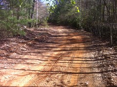
FS665-2 had seen no such attention.
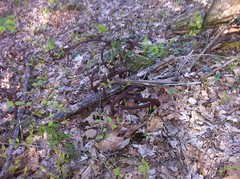
The first half mile or so was rutted and technical, but then it became tame like any other old road. I don't think the gate has been open in 10 years though. There were purple flowers blooming in the old tire tracks.
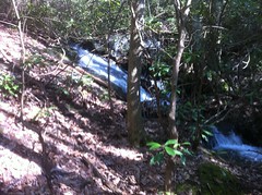
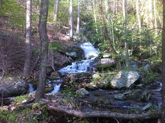
With all the rain we got this past Friday, two little streams that generally trickle down the face of some rocks had become raging waterfalls.
At the end of the road, I'd once seen a sawblade embedded in a tree there. I looked for it again today but I couldn't find it. Somebody might have removed it. There were several scars in some trees in the area where I thought I'd seen it. There were the remnants of a camp fire nearby too and a rusty old 55 gallon drum. I've seen dozens of old 55 gallon drums lying around in the National Forest. Most at what appear to be the former end of a road, or down along creeks off of old overgrown roads. My theory is that at one time, those roads were driveable and the drums mark the locations of ancient campsites. I guess before there was such thing as a fire ring, people either dragged their own 55 gallon drum out there, or maybe they were provided by the Forest Service. When fire rings came around, the drums were replaced, but in some locations, the roads had already been closed and the drums abandoned in place. This is the only one that I can think of that I've seen on a currently inventoried road.
So no saw blade, but I did see a big roll of cable.
Still want to know why there's so much cable lying around in those woods.
Ok, so many years ago I discovered that there is FS665 off of FS42 on Springer Mountain and then there is FS665-2 here, off of FS28-3. Given their names, one might conclude that they were once joined as every other FSXXX and FSXXX-N in the Chattahoochee NF is. However, I have yet to find a map showing them joined and since then, I've tried twice to find a connection between them to no avail. Why does it matter? It doesn't. It's just a mystery and I don't really know why, but I feel compelled to sort it out.
And so began the longest hike-a-bike of all time. I'll dispense with the details. You can re-create them in your head by randomly combining directions and the words: trail, roadbed, blocked and overgrown. I carried my bike for about 80% of the time and the other 20% I spent walking around with my bike parked way back up along the trail.
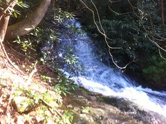
Though disappointed by lack of progress, I was not disappointed by lack of waterfalls.
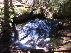
The uppermost branch of Ticknetley proper was basically just one long waterfall for as far down as I could follow it.
Cascade...
Cascade...
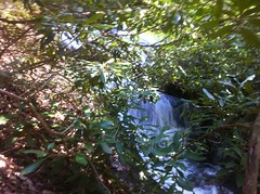
Cascade...
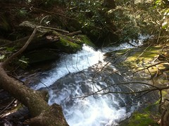
Cascade...
There were more below those too, I just couldn't get to them without spending some serious time on it.
One by one, I checked each side trail. I use the term "trail" loosely here. The most significant led directly down along Tickanetley Creek itself, and crossed it several times. It wasn't the direction I wanted to go though, and I knew for certain that eventually I'd run into some private property.
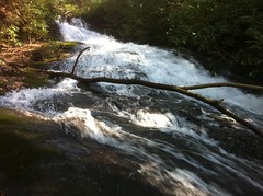
There is either no connector, or the connector is indiscernible from below. I knew for sure though that if I hiked up along Tickanetley, I'd eventually run into Old 665, so as a last-ditch effort, I gave that a try. After a few hundred yards, I could see foaming water pouring down from a great height. If I wanted to keep going, I would have to scale this waterfall, in bike shoes, carrying my bike.
Maybe next time.
Defeated, I turned around and headed home. Or maybe not so defeated. Finding that the connector doesn't exist is still a result. There is still closure in that. Maybe the road designers had planned on connecting the two roads and then ran into all those waterfalls and said screw it. Maybe they just accidentally named both roads FS665 and had to rename one of them. Who knows. The answer may be lost to the obscure history of North Georgia Logging.
On the way back, the hunger began to set in. Snack time.
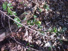
Hemlock buds are allegedly edible. I've only tried them once before because there's only about 1 week a year that you'd even have the chance to find them. Last year I saw them and said "Next time I'm out I'll try some" and then the next week they were gone except for one or two buds in the entire woods. Do they really only grow that tiny little bit each year?
I ate a handfull. They were, lets say, "inoffensive." Tender, with a hint of Pine Sol.
The sun was getting pretty low and the new leaves were looking crazy-green. I realized that my glasses might have been enhancing the green though, so I tried taking a photo through them. This is pretty close to what I see, except for the blur.
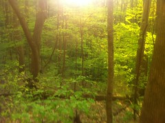
Enhancement!
The climb back up to Nimblewill was uneventful and relatively easy given how plush FS28-3 is now. I did see two Peliated Woodpeckers. I think that's what they were. Huge birds, with crests. The descent back to the car was infinitely longer than it seemed like it should have been from climbing up. I actually got a little bored. "Man, when's this downhill gonna be over?" I can't remember ever thinking that before.
On the drive home, the big bad moon was full and bright and skulking around just above the trees. The sky was still a little blue too, so it looked out of place, unnatural and extra creepy.
Again, the photo doesn't come close to capturing the moment.
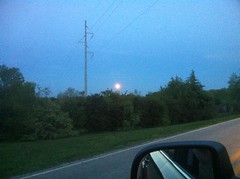
I'd come around a corner and there it was again. One step ahead of me. Watching. What do you want moon? What are you up to?
I grabbed some dinner at El Jinete in Dawsonville. They have some unusual Chile Colorado, but it's pretty good. And that's all. Not the best ride ever, in fact only about half of it could actually be called riding, but I did spend some quality time in the mountains and I climbed like 4100 feet in 25 miles. Maybe I can follow it up next weekend with some more.


Dave - I think that those remnants of barrels and wire rope are all left overs from logging. Barrels had gear oil and hydraulic fluid for the heavy equipment and the wire rope was to snatch and drag logs.
ReplyDeleteWhen I was a kid on the farm, times were tough. Dad had to sell off some timber from the farm to bring in some money.
They left behind a total mess - leaving behind many of the same things you saw in the NF.