Kirk and I went backpacking in the Smokies a while back and it was one of the best trips I've ever been on, ever. Since then, he's been trying to get me to go somewhere else and every time I'd think I could, something would happen to cast a really dark shadow of doubt on the whole thing. I could never guarantee that I'd be able to go and in the end I just had to commit and do my best to make it work. As usual, at the last minute, all kinds of things conspired to prevent it from happening, the biggest thing being that between work, racing and the trip, it looked like I'd leave my house in mid October and not see my family again until early November. They alleged that they were cool with that though, so that's just about what I ended up doing.
Kirk drove to Asheville from Chapel Hill and picked up his friend Don from the airport. Don had flown in from Baton Rouge. Kirk and Don went to med school together. I'd only met him once before but Kirk's told me various stories about trips they've been on over the years and I have an odd tie to him too. When I worked at the pet store in high school, I acquired a 58 gallon aquarium which was home to several artificial reefs and a pair of perpetually breeding Salvanis before I finally gave it to Kirk. He used it for a while then eventually passed it on to Don. So Don owns an old fish tank of mine. An odd tie to be sure, but that's how it is.
I met the two of them at Brixx Pizza by the Biltmore REI. If you ever eat at Brixx, I highly recommend their BBQ chicken pizza. After lunch, we grabbed some provisions at a local Ingles and hit the parkway. After an interminable drive we parked at the Graveyard Fields.
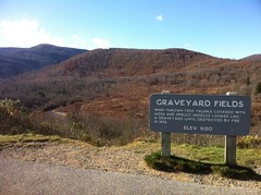
Long ago there was a vast, uninterrupted stand of spruce, entirely covering the higher elevations of the Shining Rock Wilderness. A tornado or something ripped through the Yellowstone Creek Valley back then, snapping off trees and and uprooting them, left and right, as tornadoes are prone to do. The overturned trees, covered in moss and spruce needles resembled a graveyard for years, but in the 1920's, a fire swept through and burned it all up. In the aftermath of the fire, grass grew back in and very little else has taken over since. It doesn't look much like a graveyard now, but the area still bears the name.
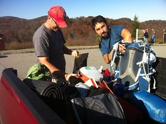
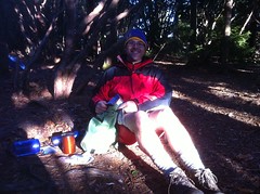
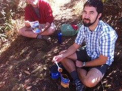
We got our gear together.
I generally pack pretty light. I've got a UL pack and UL gear and I usually just cook over Esbit tablets, but this time I brought lots of extra clothing, a camp stove and an extra can of fuel, just in case. The last time Kirk and I went backpacking, one day it rained on us, then froze, then then temperature dropped into the mid teens. I didn't have enough clothing, got very cold and used almost all of my fuel drying out what little clothing I did have. I didn't want a reprise of that. I also brought a pair of Nalgene bottles rather than a water bladder. I've had trouble with the tubes freezing in the bladders and I'd been wanting to try out the bottles, heavy though they were.
The heaviest thing I carried though, other than water, was food: 12 meals, plus granola bars for breakfast, plus a bag of miniature nestle crunch bars. Again, I've been stuck out without enough food a couple of times. Didn't want that this time.
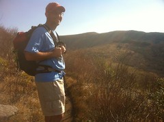
It looked like Kirk had his weight down a good bit too. He'd recently acquired a Seedhouse 2 tent, 32 degree down bag and an Air Light mat just like mine. I didn't inventory his entire pack, but it didn't look too stuffed. He was using a water bladder too. He might have been carrying less than me.
I couldn't tell what all Don had. He was almost entirely packed up before I thought to look.
It was about 4PM when we walked away from the truck.
There are 3 waterfalls in the Graveyard Fields area. We planned to check them out then head over towards the Shining Rock Ledge and camp somewhere.
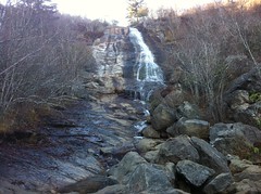
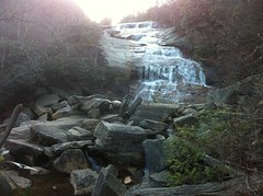
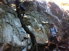
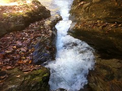
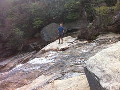
The Upper Falls was about a mile and a half west of the trailhead. When you first get to it, it looks pretty good, but unless you climb out onto the rock itself, you don't get to see the real upper falls.
The Real Upper Falls:
I half-scaled the rock to get to the top, but Kirk and Don found a trail that was substantially easier to negotiate.
I took the trail back down. As much as I suck at climbing, I really suck and down-climbing and the route I had taken up didn't look remotely negotiable from the top.
Heading back east, we discovered that we'd made an error in our navigation. We'd meant to take one trail out of the lot but ended up on another and the way it crossed the creek and teed into another trail made it seem like it was the one we'd meant to be on. We made another error later and ended up at a campsite by the creek rather than on the trail to the Second Falls but that one was more understandable, as the intersection was unmarked and the trail to the campsite looked much more heavily traveled than the correct direction. Woohoo. I've said it before and I'm sure I'll say it again. Don't trust me to get you anywhere.
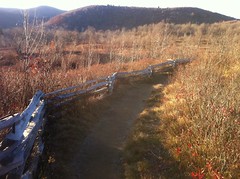
Being almost entirely grass, the Graveyard Fields are shot through with campsites, little trails leading to them and connectors between the main trails. I guess, in order to keep people from making dozens of such campsites and trails along the creek itself, somebody put up a fence along the trail from the first campsite until it went back into the woods.
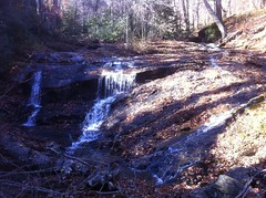
We eventually passed the trail that we'd originally meant to take and beyond that found the Lower Falls, also known as "Second Falls."
There was a photographer there who was very impressed with one of the photos he'd taken earlier and really wanted to show it to everybody. He was also pissed that there was a guy climbing on the rocks below the falls, totally ruining his shot. Seriously pissed.
Beyond the Lower Falls, we picked up the Mountains to Sea Access Trail and eventually the Mountains to Sea Trail itself where we found Yellowstone Falls.
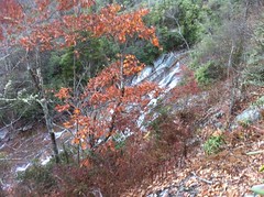
It then occurred to me on why Lower Falls is also called Second Falls. Yellowstone Falls is actually lower than Lower Falls.
There is no access trail to Yellowstone Falls. We only saw it from a nearby outcropping of rock. I'd found a trail that might lead to the top but getting to the bottom looked like a lot of work, so we left that for later.
The sun was already getting pretty low and we had a long way to go before we could camp, so we headed west.
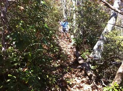
It looked like the Mountains to Sea Trail got less traffic than the other trails in the area and appeared to have been built more recently than the other trails as well. It followed the contour and there were grade reversals and other modern trail features, but I didn't get to admire them for long. The sun was setting and it was dark before we even got to the west end of the Graveyard Ridge. The Mountains to Sea Trail was a piece of cake in the dark but when we turned north on the Graveyard Ridge Trail it got a lot more difficult.
The trail was clearly an old roadbed, or more likely an old rail bed, and it was really, really chunky. It was easy to see which direction to go, but very difficult to see what you were stepping on, and we were mostly stepping on big, loose rocks at odd angles to each other. Kirk and Don flipped on their lights. Darnit. I'd brought a light with me but forgotten it in Kirk's truck. If you've never walked or ridden behind someone with a light, try it some time. It's harder than walking in the dark. Your eyes adjust to their light, rather than the dark, and the shadow in front of you is a pitch black abyss. All you can do is stay close to the guy with the light, plan your route and hope you don't fall back even a few feet. That's what I did. It wasn't easy, but it worked out.
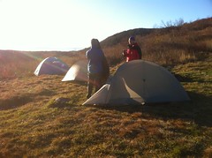
Along the way, we decided to camp at Ivestor Gap. It had gotten cool while we were walking but as we neared the gap, the temperature dropped substantially and at the gap, the wind was blasting through furiously. We set up our tents but there was no possibility of fire. Kirk and Don hung out in the vestibule of his tent, sheltered from the wind, for about an hour but there wasn't enough room for the three of us. I was fast-flying my tent, so I pointed my vestibule directly into the wind, staked it down hard against the ground and stuffed my pack and other gear in there to seal it up as much as possible.
It more or less worked. I was warm all night and I didn't feel a draft, though the wind knocked my tent around like I've never seen before. I didn't get the best sleep. The wind kept waking me up. Hey, that's camping though, right? How often do you get to be woken up by the wind trying to blow your house down?
The next morning, I awoke to something gross but also very funny. I'd had a bit of a cold the previous week and my nose was still slightly runny during my ride at Chickasabogue and during the race in Albany. I hadn't washed my gloves in probably a month, so I'd been rubbing my nose with very dirty gloves for two days. As a result, the inside edge of my right nostril had gotten raw, infected and swollen. That night, it had apparently oozed and oozed and with the cold temperatures, some kind of frozen oozesickle had formed. When I noticed it, I just instinctively pulled it off, but it didn't come off easily and I ended up tearing out about 7 nose hairs out in the process. It reminded me of a Dirty Jobs episode where Barsky gets his nose hairs waxed. The pain was brief but extraordinary, and I couldn't help laughing at the same time.
There was ice on my rain fly, so it had apparently gotten pretty cold during the night. The wind was still blowing. It refused to quit, but it was way less windy than the night before. Between that and the direct sun, it wasn't uncomfortable to walk around with a jacket on.
I ate granola. Kirk and Don had coffee.
Looking around, I saw two other adults and about 20 kids milling around. We'd seen a few of them the night before but I had no idea there were that many. One of them had apparently lost his sleeping mat. The wind had carried it away and dropped it in the briars behind us. The lee created by our tents may have been the only thing that kept it from being carried off the mountain. The kid who lost it was really excited to get it back. I can imagine. Lately, my sleeping pad has been leaking down slowly and when I wake up to pee at night, I usually have to re-inflate it a bit or else I get really cold. It would have been terrible not to have had one at all. I didn't see any tents either. I think they were all in bivvys or maybe just under a flat tarp.
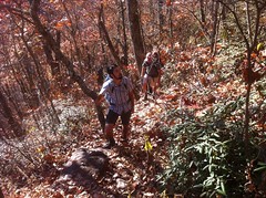
After breakfast, we hit the Art Loeb trail, directly up over Grassy Cove Top.
Grassy Cove Top is at the head of Greasy Cove Ridge, with Greasy Cove Creek down to the south. It would make sense to call it Grassy Top because it is very grassy, but why Grassy "Cove" Top, when the cove itself is "Greasy" Cove? Is it a just misspelling on the map? Is it a misunderstanding that has persisted over time like Etowah -> Itowa -> Hightower in Georiga? I wonder.
We hiked north to Flower Knob.
From somewhere in there, I think from Grassy Cove Top, way in the distance, we could see a quartz deposit sticking out of some peak ahead of us.
That must be Shining Rock!
When my brother and I were up there a while back, he'd told me that the mountain was covered in quartz and that in the winter, from a distance, it really stands out. He and I had seen blocks of quartz scattered around the west face of Shining Rock and I just assumed that the whole peak was covered in blocks like that one spot. Man, I was wrong! There's a huge outcropping up there, we just didn't get to see it.
The intersection at Shining Rock Gap is confusing at best. If you mean to continue on the Art Loeb Trail, it would be easy to end up on the Old Butt Knob Trail by mistake. Meaning to end up on the Old Butt Knob Trail though, we just stayed right and it worked out, which was fortunate because I noticed that we had gone through an intersection, but didn't recognize it as the confusing one and then kept thinking we just hadn't gotten to it until later. Woohoo!
The Old Butt Knob Trail split, not 100 yards north of Shining Rock Gap. We didn't know which way to go and the map made it look like we needed to proceed directly up the ridge. Both trails were maintained. Thinking we hadn't yet come through the confusing intersection, and that the trail to the right might be the Shining Creek Trail, we went left, up the ridge. This turned out to be wrong, but also awesome.
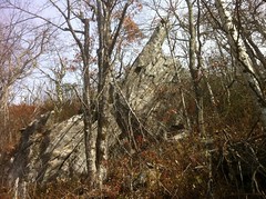
Almost immediately we were presented with a cliff of pure white, shining quartz. It was Shining Rock. We'd hoped that the Old Butt Knob Trail would take us past it, but we didn't think we were that close yet.
Kirk immediately started climbing the rock and I followed.
It was about like climbing the Chimney Tops in the smokies, but without the driving wind and rain that had forced me down the last time I tried.
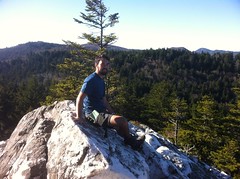
We made it to the top without much trouble and took in the view.
Meanwhile, Don discovered a trail that led to exactly where we'd stopped but didn't require any actual rock climbing.
We hung out for a half hour or so and took the trail back down.
Ok, so the other trail must have been Old Butt Knob and the Shining Creek Trail must have come in earlier where we kind-of thought we saw a trail come in but weren't really sure and that intersection earlier must have been Shining Rock Gap. We backtracked and got on course, this time confident in where we were.
The hike over Dog Loser wasn't too difficult. We stopped at Spanish Oak Gap and ate some lunch. Being between Dog Loser and Old Butt Knobs though, Kirk had been calling it Dog Butt Gap.
Speaking of which. When my brother and I last hiked up there, he had the map and I'd only looked at it a couple of times. I'd noticed Old Butt Knob because it had such a funny name, but later on I didn't specifically remember the name. While sleeping on the first night of that trip, I had a dream that we were out hiking in the same area, but on the map, instead of Old Butt Knob, it said "Old Crotch Balls" which didn't seem funny in the dream, but I actually laughed out loud when I remembered it the next day. John laughed when I told him and Kirk laughed when I told him later and then it was funny again on this trip. Sitting there we were joking about it. In a few minutes we would climb up over Old Crotch Balls.
The climb itself was anticlimactic. It was just another random knob without any particularly interesting features, other than the name. I really want to know how it got that name though. Dog Loser is sort of obvious. I imagine someone lost their dog up there, or maybe more than one person did. Old Butt Knob though? Did someone find an old rifle butt up there? I want to know.
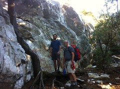
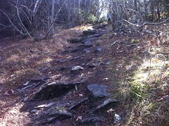
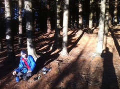
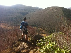
The descent off of Old Butt Knob was the steepest, roughest, sketchiest descent I've ever done, hands down. With all the leaves, I would even call it dangerous. You'd think you'd picked the right place to step, then the leaves would slip out from under you. I slipped, probably twenty times, and I was trying hard not to. I had to put my hand down to save at least half of those. I was perpetually concerned that I'd break an ankle or wrist. Kirk was in front of me and he slipped too, but not nearly as often. He was wearing trail running shoes with lots of little blocks on soles. My Keens have much bigger blocks. Until that day, they had not presented a problem, but on that descent, I really wished I'd had his shoes.
This photo doesn't really capture it, but you can see Kirk with Don behind him and how steep the trail is.
The entire drop from Old Butt Knob to Shining Creek Gap was that steep or steeper. Sketchiest downhill ever.
There was one overlook on the way down, on a granite outcropping, and we stopped there for a few minutes.
I've seen trees growing out of rocks before, but usually there's a bed of soil on top of the rock, or the tree has roots going down and around the rock, but not this one. It was growing directly out of the rock itself.
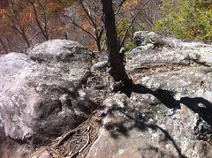
I'm sure there are some roots going down through cracks in the rock, but it looked impressive.
From the overlook we got a good view of Shining Creek Cove.
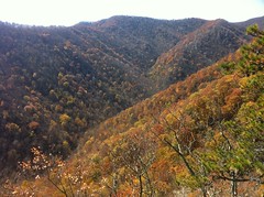
Later, we would climb back up along the creek, way down in there.
I think it was there that it occurred to me. My impression of the scale of everything was way off. Just looking at the map, the trail didn't seem like it should be as steep as it was and the cove didn't seem like it should be that deep. It turned out that the inch-to-mile scale wasn't confounding me, it was the topo lines. In most of North Georgia, on the USGS maps, each line represents a 20 foot gain in elevation, but the topo lines on the map we were using represented a 50 foot gain, and the lines were about as dense as the lines on the maps of North Georgia. So, just glancing at the map, intuitively, everything seemed to be about the same scale as what I'm used to, but in fact, everything was two and a half times steeper.
Ha!
The mystery was solved but unfortunately it didn't make the descent any easier. Here and there we could see the road below us, but every time, it seemed incredibly far away. At infinite length, we finally made it to the intersection with Shining Creek and collapsed for about twenty minutes, pigging out on snacks.
My Nestle Crunch bag was already running low. We'd gone through over half of it in under a day and a half. Without strict rationing, we would run out. They were so good though. Next time, I'm bringing more, or at least some other huge pile of chocolate.
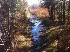
We tanked up on Shining Creek.
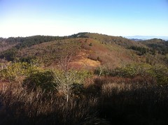
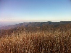
So far, almost every trail had been unfamiliar in one way or other. The Graveyard Fields and Black Balsam areas are very grassy with only sparse balsam, magnolia, rhododendron and other scrubby brush growing randomly. There are a few stands of spruce here and there, but not many. You can see a long way and with the season, everything is brown, and it looks way out of place for North Carolina. Actually, it looks a lot like photos my brother took in California. Shining Rock is covered in spruce, but again, I don't see spruce anywhere in Georgia. Spruce is crazy. It grows all year and it's so dense that very little grows beneath it, and the ground gets inundated with tiny little needles. Beneath a stand of spruce, it looks like somebody cleared everything out and put down a carpet. Very weird if you don't see it a lot.
On the Shining Creek Trail though, it felt very familiar. We were at a lower elevation, I recognized all of the trees and bushes, the trail was an old roadbed, or perhaps an old railbed, and for the first time on this trip, we were following a creek. I love new terrain and new surroundings but it's amazing how comforting it is when you suddenly realize that everything around you is familiar.
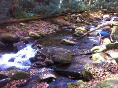
As we climbed, various things caught our collective eye and we made several little excursions down to the creek.
Here there was a large pool that dumped out through this little chute in the slab of rock below it in massive surges.
We saw 2 snakes, exactly alike.
I think that's a "brown snake." The line down its back and the crosshatches to either side make me think that, but it could be some other snake that's not found in Georgia.
Don noticed a waterfall when we stopped for a break at Daniel Cove Creek and me and Kirk went up to check it out.
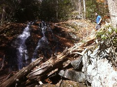
There was a wide falls on the north prong of Shining Creek itself.
As we got higher up though, our interest in off-trail excursions diminished proportionally. It took an eternity to get to the switchbacks near the top, and more than once, we thought we were there, only to discover a few minutes later that we weren't. Short of counting steps, it's very difficult to tell how far you've gone up an unfamiliar valley. There's just nothing to take a bearing on. Yeah, the map shows creeks coming in from each side, but there are more creeks than the map shows and it's easy to mistake one for another.
When we finally did reach the switchbacks, we were all ready to be done and it took a good push to get to the top. By then, it was about 4PM or so and we were all in favor of making camp at Shining Rock Gap. Ironically, it had been 4PM when we had STARTED the day before.
Nobody could remember whether it was OK to make a fire or not. There was a fire ring where we camped, with coals in it. The map had all kinds of info on it but nothing that said one way or another about building a fire. When John and I were there way back, there were signs saying not to build a fire, but I think that was because of a recent drought and we didn't see any such signs this time. We built a small fire.
I say we. I started the fire and got it going pretty well, then suddenly it burned out almost completely. Don was a former scout though and his fire-building skills were second to none. He fixed my busted old fire with authority and within minutes we were swimming in its luxurious warmth.
The night before, I'd eaten a Mountain House meal. I'd bought one at REI, but the rest of my meals were instant potatoes and noodle sides. I just reused the Mountain House bag to cook them. The potatoes were excellent. They cooked up instantly and were very filling. The noodle sides didn't work out as well. Even after sitting for as long as the Mountain House meals, the noodles were still hard and already getting cold. Plus, they weren't nearly as filling as potatoes, and slightly heavier. No good.
As night fell, the temperature dropped precipitously and the wind picked up just as it had the night before. I want to know exactly what phenomenon is responsible for that. If the temps fall, then yeah, the wind would blow from whatever direction is still warm, but why so suddenly and why so hard? Is it just like that at this elevation, this time of year? You tell me! I want to know!
We had camped in a stand of spruce though and we were very well sheltered from the wind. I slept well all night. I don't remember waking up except once, briefly, to pee and re-inflate my mat.
The next morning though, when I did wake up, I had a splitting headache and I felt really weak, like I hadn't eaten enough or had enough to drink. I ate some breakfast and drank as much water as I could, but it turned out that I wasn't that thirsty. It was weird.
The next leg of our journey would take us up to Cold Mountain and back. We left our tents behind and only packed as much gear as we needed. This left my pack saggy and floppy so I took my spare clothes too, just to fill it out.
On the way out, we passed the same blocks and blocks of quartz, strewn about the trail and up and down the hill to either side, that my brother and I had seen before. If we'd gone straight uphill it would probably have put us at the foot of the big deposit.
The trail followed another old rail bed for a while but diverged at the foot of Stairs Mountain. I think the Ivestor Gap Trail, the Graveyard Ridge Trail, The Shining Rock Gap Trail, the Art Loeb Trail between Shining Rock Gap and Stairs Mountain and at least part of the Greasy Cove Trail were all old rail beds. They're dead flat, wide and fairly straight. The back of Kirk's map indicated that some of the trails follow old rail beds and that there were once saw mills at the Sunburst campground and the Daniel Boone Boy Scout camp. Both of those, however, are at the very foot of the mountain and all these trails are way up at the top. How did they get the logs down? The Little East Fork Trail follows an old roadbed and leads from Shining Rock Gap down to Daniel Boone, but it's incredibly steep. Did they unload logs and skid them down to the sawmill? Was there a flume? Did they use geared locomotives and really, no kidding climb the Little East Fork? It has about a 20% grade. I know the geared locomotives could climb grades in excess of 10%, but what about 20%? Hell, it's a tough climb on foot. If it really was a railway, man I'd pay good money to see a locomotive climb it.
Stairs Mountain was much easier than I remembered it being. It was nothing. For some reason I'd remembered it being really tough.
I tried to take a representative photo of The Narrows but it didn't really work out that well.
The Narrows is a thin ridge running from Stairs Mountain to the foot of Cold Mountain and the trail winds back and forth over it from one side to the other. You can often see off both sides at the same time. The views are spectacular, though not much different from the views off the side of any other trail we'd been on. When my brother and I hiked it, it was totally foggy and we couldn't see 10 feet. This time, we could see for miles. The drops to either side weren't as steep as I'd expected though. I half thought that I'd be scared to walk along the ridge but it was fine.
We paused at Deep Gap and snacked. My headache had gotten worse but I wasn't dehydrated. I'd had to pee several times already. I only felt a little hungry. It was weird. I still felt a little weak, like maybe I had low blood sugar, but eating the last few crunch bars had no effect except to completely deplete my stash.
We pressed on. The trail up Cold Mountain is long and steep. It mostly leads directly up the fall line, and as you might imagine, is deeply below grade and full of chunky rocks.
We passed God's Finger, which I'd remembered being on Stairs Mountain and had been surprised not to see there.
Maybe it was Cold Mountain that I'd been thinking of as earlier as being so difficult. Maybe I just had it and Stairs Mountain confused.
It took forever but we eventually made it to the ridge that leads to the top. The trail along the ridge is much more overgrown than at lower elevations. Most of the time, you're walking through a narrow tunnel of brush and constantly getting touched on both sides by bushes and small trees. It wasn't comfortable, but it was way better than when my brother and I were up there with fog condensing on every leaf and the walking shower that ensued.
The trail near the top was even steeper and rockier than below...
...but eventually, we made it...
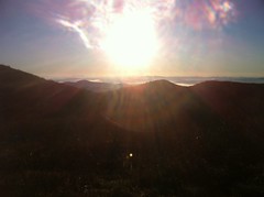
 ...and for our efforts, got a good view of the ridge we'd walked along earlier that day.
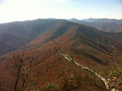
It was definitely lunch time and I ate the hell out of some potatoes.
Man, did I eat those potatoes. I think I like potatoes better than any other camping food. Maybe if I added some crumbled up beef jerky, they'd be even better, but really, salty, slightly buttery, but otherwise plain potatoes taste so good when you're hungry. I'm getting hungry right now, thinking about them.
The descent back down off of Cold Mountain was the fastest I've ever gone downhill on foot. We steadily leapt from rock to rock, almost jogging, all the way to Deep Gap. Whenever it flattened out a bit, we did jog. Still though, despite the lower elevation, less work and having eaten, I still felt weak and my head was still splitting. Kirk joked that it might be altitude sickness, but we were only around 6000 feet and I didn't have most of the symptoms. It hurt and it sucked. That's all I can say.
The trudge back to camp was just that. A trudge.
When we arrived, we packed up and I ate the spare noodle side that I'd brought "just in case", but I felt no better for having eaten it.
I had another problem to manage too. All that rough descending had started some nice blisters. Fortunately, the walk out was comparatively flat.
Unfortunately it was really, really wet.
Flat or not, we kept having to leap from rock to rock. Ugh.
Also! Like almost everyone else in the world, Kirk and Don are slightly taller than me, so their stride is slightly longer. I can easily keep up when we're climbing or descending, but when it's relatively flat and we're marching, I have to stretch out each step. That or every ten steps I have to jog a few. It's funny being short. Now that I think about it though, I'm not sure that I don't just have an unnaturally short stride. I noticed in New Orleans that it's hard to keep up with my dad when he's walking and I used to call my brother "Johnny Long Step." My dad is only a half inch taller than I am and John is actually shorter. Maybe it's just me. Whatever it is, I really noticed it on the hike out that day.
We walked out all the way to the Black Balsam Parking Lot and made camp in a small stand of spruce to the north.
A lady and her husband were grilling chicken or something over their fire and a forest service guy was talking to them. He didn't say anything about their fire, there was an actual metal grill on top of theirs too and there were several rock rings scattered about so I figured it must be OK. We would build another fire.
Firewood was difficult to find though. There were plenty of little bits for tinder but nothing substantial except an entire tree that someone had cut down, lying right next to our ring. It was hard to find anything else. There were stumps everywhere though and plenty of dead trees in the stand. It looked like people had just started cutting them down. Every branch within arms reach had been torn off too. All the way around the stand there were thick briars, but there were a couple of "trails" through them and eventually we found enough large branches to make a decent fire.
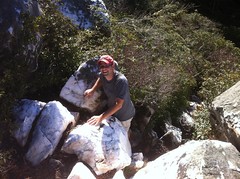
A decent fire:
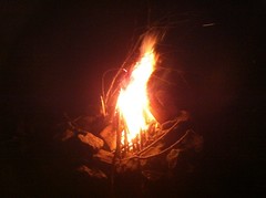
Decent. Ha! Our fire was monumental. It rivaled the Great Burn that my brother, Kirk and I achieved at Tsali, in 2000. Again, I got it started, failed to keep it going and abandoned in disgrace. Don then brought his unrivaled skill to bear and constructed the raging inferno pictured above.
I can't believe how badly I suck at getting a fire going. I don't remember having that much trouble in the past. I hope that I'm just out of practice. Whatever it is, I took good notes this time and maybe my next fire won't suck so badly.
We put the end of the tree that had been cut down into the fire and it blazed forthwith. Periodically we had to advance the tree.
"Advance the tree!"
"Advance the tree. Aye! Advancing the tree."
That night I slept as well as the night before. Somehow though, my mat got turned sideways so much that both of my feet were sticking out from under the fly. Of course, I also had to re-inflate it halfway through the night too. It only leaks down a few breaths but it's surprising how big of a difference it makes to have it fully inflated. Again, for whatever reason, the temperature dropped significantly and the wind howled through the trees like a train whistle. I'd list that as a problem if I hadn't slept completely through it.
The next morning the sun shone in directly onto our tents and though it was in the low 40's, the direct sunlight made it warm enough to sit around comfortably. We sat in the sun and ate.
My feet felt a lot better; the blisters had flattened out. Even better though, my headache was gone and I felt strong again. I don't know what it was but it was totally gone.
We packed up some light gear and headed over to Sam Knob.
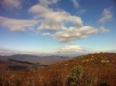
Sam Knob is right by the lot and not that much of a climb, but the views from up there rival anything we'd seen yet. The topography is much more complex at the south end of the Ledge and the foliage is much more diverse.
For the first time in days there were clouds in the sky. On the horizon, they even looked dark.
There had been a 0% chance of rain all week, but that day, there was a 50% chance.
A huge pile of young teenagers were hanging out at the top and we more or less followed them back down. Between them and the kids we'd seen at the beginning of the trip, it made me think... Why aren't they in school? Kirk said that the school his son Jack goes to takes nature-based field trips sometimes and maybe that was the deal, but the first group had been out for an overnighter. Maybe they just have better field trips in North Carolina. Like so many things on that trip, it made me wonder.
I'd seen this on the way up, and I stopped to take a photo on the way back down.
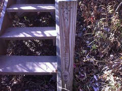
"Wildness." Every now and then, I see graffiti that makes me chuckle a little. I guess technically, there is wild-ness all around, as it says, but I'd bet that the word the artist was looking for was actually "Wilderness", with an "er" in the middle. Even then though, Sam Knob is actually located outside of both Shining Rock and Middle Prong Wilderness Areas, so actually there is only Wilderness proper to the south and west. E for effort though.
At the bottom, we caught up to the group of kids and the adult that was with them struck up a conversation with us.
"Where you guys from?"
"All over - Chapel Hill, Baton Rouge, I'm from Atlanta."
"All right! Well, at least you all speak the King's English."
I've heard that idiom before but I don't know what it means. Thinking about it now, I guess it means something like "Well, even though you're not from exactly where I'm from, we're all countrymen. Therefore I like you." But, at the time, the first thing I thought of was kind-of racist and I felt bad for thinking it. Why did my mind even go there? You tell me. Here's what I thought... A long time ago, Kirk mentioned to me that one of his friends, it might have been Don actually, had either spent some time in India, or knew somebody from India really well, or something like that, and when the two of them first visited North Carolina, they noticed that virtually every small hotel in the state was owned and operated by an Indian couple. As such, Kirk's friend was all "Let me handle this..." and he haggled with the owner, in formal Indian tradition. The owner was so delighted to have anyone even attempt to haggle with him, that they did so, excitedly for like 10 minutes. In the end Kirk and his friend got an incredible deal on the rooms. They then repeated this all over the state with similar success. Since then, I've noticed the Indian hotel owner phenomenon myself, and though I've been reticent to actually haggle, it has crossed my mind, over and over. At any rate, when this guy said this thing about "the King's English" I immediately thought "As opposed to the English that you hear at every hotel in this state. Am I right? Eh? Eh? Ha ha!" Thank god I had the presence of mind not to actually say that, but why did it even come to mind? Why?! To return balance to the universe, each of my Indian friends are now required to denigrate me in some clever, semi-racist manner. Have at it.
The Sam Knob trail is an old road bed. It didn't strike me as a rail bed because it was highly variable in grade. It was however a really good example of how big a difference the canopy makes in a wet climate. I've hiked and ridden dozens, possibly hundreds of old roadbeds, some recently, which were really sandy, in Mobile, but none were even nearly as eroded and braided as Sam Knob.
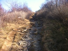
Rain just hits the trail full force. A couple of trees go a long way.
Back at camp, we packed up our tents and headed up to Black Balsam. The former route of the Art Loeb that leads up to the top it's in as bad a shape as Sam Knob, for the same reason. It has been rerouted but people still go the old way. I guess it's just not intuitive to go any other way. It could really use some signage or something.
I've been up on Black Balsam before so I didn't see anything new at first other than the weather that was really starting to move in from the west. But after looking around a little, I happened upon this grave marker.
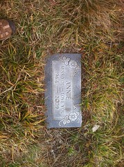
I certainly didn't notice that the last time. 2009 though. It may not have even been there. Who was Annie? I've seen markers for dogs before - there's one at FATS and another on the Wagon Train Trail near Brasstown Bald, but 1964-2009 is 45 years. Was Annie a horse or a mule? That's even old for a horse or mule, and horses and mules aren't allowed on Black Balsam. Maybe they were though, way back. If it was a person, I'd think they'd put her last name on the marker too. So, who was Annie? So many questions on this trip.
Kirk had a list of objectives for the trip and as it turned out, we'd accomplished all of them a day early. We could either camp near the car for another night or just head out. It looked like it might storm on us later, we were all a little tired of camping and we all had at least minor blisters so we decided to head out.
The Mountains to Sea Trail took us back to Graveyard Ridge, which we then took back toward the lot. We ate lunch somewhere along the Mountains to Sea Trail. I could barely force down another bag of noodles. They tasted like they were flavored with pure salt. No more noodles for me. Potatoes forever!
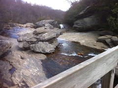
Eventually we picked up the trail that we'd intended to take out on the first day. It crossed Yellowstone Creek near a little shoal or something.
"You want to drop our packs and go walking around on the rocks?" Kirk asked.
"Yeah... I mean, I do. But also I really don't." I replied. But then, as if I had no specific control of my body, I found myself walking out onto the rock anyway, carrying my pack, gripped by curiosity. I'm sure Kirk thought that was odd.
We walked all over the rocks.
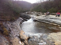
It was an interesting little shoal. Several feeder creeks poured off the hill onto the rocks, right there. It also turned out that just downstream was the top of Second Falls.
No doubt our climbing around pissed off another photographer on the landing below.
The climb up to the lot was very steep, but it was also paved so it was easy to keep a tempo. As Kirk stepped into the lot, he exhaled really loud and amused a group of day hikers standing nearby. They asked a few standard questions. Where are you from? How long have you been out? Did you see any wildlife? Thinking about that last one, it occurred to me... Other than birds and squirrels, we'd only seen two snakes, a dead mouse and a dead shrew the entire time and I'm not sure those last two count as "life." In retrospect, it was kind of disappointing. We'd seen a lot of stuff, but not much wildlife.
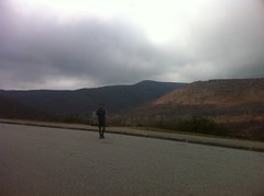
A storm was definitely gathering on the horizon.
We trucked it out of there. Don had a flight out the next day so he and Kirk got hotel rooms. We all showered. Not together, in case that's what it sounded like. You know how when you're showering, sometimes the water will turn sort of brown as it runs off when you're scrubbing a particularly dirty part. The water running off of me was perpetually brown or black for the entire shower. It got especially dark when I washed my hair. I didn't realize how dirty I'd gotten until I started to get clean.
And so ended the great Shining Rock Adventure. I put on the spare clothes that I'd been carrying around all week but hadn't needed and we grabbed some lunch at Brixx again. The pizza was as good as I'd remembered. No offense to Mia's, but I wish there was a Brixx somewhere in Atlanta.
The drive home was uneventful. I only got rained on for a few miles. I'm not sure how bad it was up in the mountains, or if it ever got bad. I had over 1000 emails when I got back, though most of them were from a malfunctioning monitoring system. Still, there were at least 100 that I had to pay attention to. I stopped at the gas station and while I was there, I got a coke. Mmm. Coke.
I say this all the time. I love the outdoors but the outdoors makes me really love civilization. It's hard to believe how good a warm shower or a cold coke or a friendly email can feel sometimes.
The things we take for granted.


I don't know who the Old Butt was, but I bet his motto in life was, "Switchbacks are for pansies. Now where the Hell is my dog?!?!"
ReplyDeleteI'm just glad to have been part of the expedition that coined the phrase, "ADVANCE THE TREE!"
Hell yeah.
ReplyDeleteAdvance the tree!
As a reminder, fires are NOT permitted in any wilderness area. A sound policy is to dismantle any fire ring you see so as to dissuade subsequent hikers from building a fire as you did. Remember, no trace camping means "no trace" camping. Peace
ReplyDelete