A long time ago on some forum or something, I mentioned that I'd done a long ride up at Bull Mountain and I think it was Neal Nichols who joked in response that I probably rode there from my house, which is like 40 miles away. Ha, ha, we all laughed, but apparently the incident planted a tiny little seed in the back of my mind.
When I leave the house for a road ride, I rarely have a destination in mind, I usually just feel out a route, but over the next several months I found myself feeling like riding further and more directly north. A few weeks ago, about ten miles into the ride, it suddenly occurred to me that I wanted to ride to Bull and back and I got as far north as the kangaroo place before running out of time.
Today I had all the time in the world though and for the first time since The Circumnavigation of Lake Lanier, I left the house with a purpose.
Dawsonville used to seem like a long way away but I barely noticed the ride up today. It was familiar and I guess that makes the miles fly by.
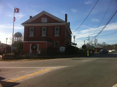
I'd eaten only a bowl of Raisin Bran that morning and my stomach was feeling a little empty so I stopped at a gas station just off the square for a pair of Whatchamacalits. One, I ate directly, or at least about 85% of it directly. The other I saved for later.
The last few times I'd been up that way I'd headed east out of the square and then North on whatever road becomes Bailey-Waters. I don't know why but today I felt like heading due north on Shoal Creek and picking up Hwy 136 instead.
I doubt there was any difference in distance or terrain though, and before terribly long I was again at the kangaroo place.
I actually got kind of excited as I rolled by, I guess because I hadn't made it that far yet and for the first time it appeared like I might actually achieve my goal.
It had always seemed like Bull Mountain was only about 5 miles north of the kangaroo place, but I think that's just because I've always been driving. If it's only 5 miles, it's a long 5 miles. And hilly. HILLY! About halfway down Bailey-Waters I could see the Blue Ridge barely peeking over the top of the hill.
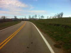
My destination was at the foot of that ridge but it looked so very, very far away.
A mile or so after jogging right on Hwy 52 a girl screamed as their car passed and it startled me half to death. I can't remember the last time I shook so hard when somebody yelled at me but man, I shook that time.
It seemed like it took a year to get to Nimlewill Church Road, and I really didn't remember all those little rollers being there. The ride down to the church itself flew by though and before long I was in the lot, in sight of my goal.
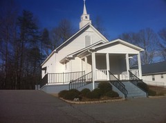
The aforementioned goal, achieved:
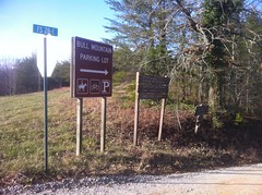
Or, at least, half achieved. For it to truly count, I had to make it back home too.
As I stood there, screwing around with my phone, a guy with a mountain bike on the back of his car drove by and waved. When I rolled out, I noticed a lone car parked in the Jake Lot too with somebody sitting there, either about to head out or just getting finished. Just up the road, I passed another guy with a bike on the back of his truck and he waved.
It was surreal being there on the road bike, kind of like when I volunteer at a race. My instincts tell me to be excited and that I should be doing all the things that I normally do to get ready for a ride. But what is this? I have no mountain bike! Did I forget it? Oh, wait, no. Everything is fine. I'm here for something else. But, wait, my bike! Oh, yeah, heh, remember... Not here for that. ... My bike!? And so on.
It wasn't until I was well away from the lot that things started to seem normal again.
I stopped briefly at the old Grizzle's Store.
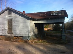
Long ago I used to take a route up to Bull that went right by the store. Now I go a different way and I realized that it's been a really long time since I'd last seen it. I had to stretch my mind a bit to remember, but it was when Billy Pickens and I rode up there after Hurricane Ivan had taken out a bunch of bridges. We couldn't drive to the church from either direction, parked at the store, rode down the road and had to hike-a-bike across a creek where one of the bridges had been washed out. We then proceeded up to Nimblewill Gap, quadruple-flatted and I had to ride a flat tire down FS28-3 and beyond to Hwy 52 and then head east in the dark while Billy went and got the truck. It was quite an adventure.
I took Hwy 52 east to Hwy 9 and then headed south. It was somewhere in there that I first felt like I would actually make it back. For some odd reason, I never feel like I'm making real progress until I turn and head in the general direction of the end. Even if I'm well over halfway, until I make that turn, it just doesn't feel right.
I had to stretch my mind to remember the last time I'd been on that section of Hwy 9 too. It was AGES ago, even before that quadruple-flat adventure, probably 2002 or so. There are some big, twisty climbs up off of the Etowah. Yes, indeed, there are.
Somewhere, not too far north of Dawsonville I rode past this burned up old homestead that was too interesting to just ride on by.
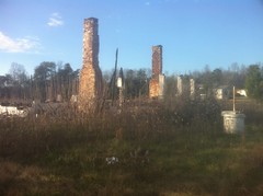
The dual chimneys are still standing, along with the brick columns that held up the porch, but the rest is a total ruin. Kathryn would have loved it. She loves old broken down buildings.
Not far south of that I started to get light headed and weak-kneed climbing some long, steep hill. I was short on calories and there were a gazillion miles left to ride. I ate the little nub of the first Whatchamacalit and eased up, but it wasn't enough. I was getting weaker by the mile. It was that long, slow bonk where you either barely drag yourself home after teetering on the edge of hypoglycemia for hours, or suddenly crater halfway up the last hill.
I stopped at a gas station in Dawsonville again. This time it was the one across the street from the last one I'd stopped at. I refilled my bottle, ate the other Whatchamacallit, warmed up in the direct sun for a few minutes and hit the road again.
It's only about 20 miles from the Dawsonville square to my house but it was the longest 20 miles in the world. I never really bonked but I never really recovered either.
A few miles north of town I jumped again when an Outback just like mine (but green) drove by and the dog in the back seat with it's head out the window barked as it passed. For some reason, apparently, I was all nerves today.
As I rolled into town it wasn't officially dark, in that you couldn't really see any stars yet, but everybody's headlights had been on for a long time and I'd turned on my flasher ten miles earlier. I had a red, rear flasher, but nothing up front. I own a little white bar-mountable light, I should just put it on my bars and leave it there all winter.
I'd mentioned before heading out that I was worried I'd be about 15 minutes short on time and it turned out that I was right on the money with that prediction. The hills in my neighborhood seemed taller than ever, especially in the failing light, and for some reason there were dozens of people coming home from work, right then too. I made it though, and all's well that ends well.
I wasn't sure of the mileage before I left. I guessed around 70 miles and upon returning, I checked Google Maps and it shows it to be right about that far. Not too bad of a ride. I've been hoping to get in some longer rides this winter. Next time I'll have to manage my nutrition a little better but it felt like a pretty good start.


I'm surprised you didn't ride up to the game check!
ReplyDelete