Finally, something interesting...
Seems like it's been quite a while since I did anything but ride around town, in the cold, by myself. I guess it actually had been a while, over a month. But this past weekend Iz had a gym meet in Charleston, we turned it into a nice little family trip, and I managed to get in about 4 hours of road bike tourism Saturday morning while everyone else slept in.
In Atlanta, it'd been raining and sleeting and threatening to freeze hard all week. The schools had even been closed, just in case. It was about ten degrees warmer in Charleston though, and though I'm sure the locals were freezing, it was balmy to me.
We stayed at a fairly inexpensive "Inn" (motel) on Montague, and though I didn't see any water nearby, there certainly were a lot of ducks creeping around the property.

They seemed to share my opinion of the weather.
It seems like ducks usually either avoid people or accost them for whatever food they might have on them, but these acted a little weird. They were completely ambivalent to us. I walked right through the middle of their little gaggle (or whatever a herd of ducks is called) and they just parted and let me through without so much as glancing in my direction.
It was weird.
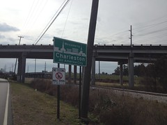
The map I had in my possession was somewhat crude. I'd torn it out of a "See Charleston"-type booklet that they were giving away in the hotel lobby. It seemed to have just enough detail on it though, and I figured as long as I could keep track of which way was north, I'd be OK.
Rivers Avenue was just to the East, across I-26. Of that, I was fairly certain. The map showed it heading all the way down to the harbor. That's generally where I wanted to go, so I headed in that direction. As luck would have it, I found Rivers Ave., right where it was supposed to be, and in fact, it led right where I expected it to go.
I'd say, if you want to see a good cross section of Charleston, take Rivers Ave. from Montague to the harbor. You'll see just about everything.
It's a little low-income up at the north end. Some of the shops have great names, like "O G Cutz" and "Super Bad Men's Clothing". There's a combined bike-bus lane, and I had to work to keep ahead of the bus. It had to keep stopping, but then it'd almost catch me before the next stop unless I kept an eye on it and put in a little effort.
After a while, it got kind of industrial, I ended up following some train tracks, and I-26 was on the right. Somewhere in there I entered Charleston-proper, as opposed to North Charleston, which is where I guess I was before.
A little south of there, the streets started getting narrower, and lined with little buildings. At the time, this was great because I'd been dealing with a murderous crosswind from the east all the way down Rivers Ave. and I was getting a little tired of it. I'd ridden Open Pro's for like 8 years, but after breaking one of my rims a few weeks back, I borrowed an old set of Ksyriums from my brother. I don't know if it's the taller profile of the rim, the bladed spokes, or both, but there's a world of difference between them and Open Pro's in a crosswind. Man! Little did I know what the rest of the world has been dealing with all these years.
But I digress. Back to Rivers Ave...
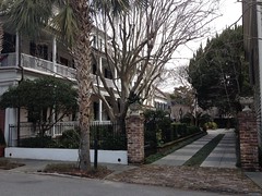
Before long, things started looking a little more urban. The houses began to take on a historical look, and they all looked about the same - 2 story, 1-room wide, 2 or 3 rooms long, with porches on both floors. At first, it was still a little low-income-looking though. Very few houses looked to be in great shape, but they all appeared to be holding up.
Then there was this weird strip of what, despite how fancy they looked, also looked like public housing...
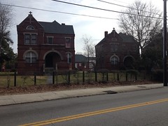
Dozens of those old little brick houses. Much sturdier than the private dwellings, for sure, and bigger yards. I guess I'm not totally sure if they're really public housing or not, but they really had that kind of a feel, looking at them.
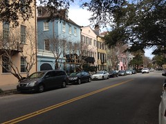
Bit by bit, the maintenance level of the houses improved, I started seeing shops, then more shops, then only shops.
Palmetto trees lined the streets.
Some folks appeared to be proud of their heritage.
There was a park on the left, Francis Marion Park, I think, and the lavish Francis Marion Hotel on the right.
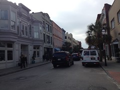
Somewhere in there, the name of the street changed to King Street and I noticed it was now one-way, fortunately in the direction I was going.
People were out running and walking their dogs. I saw a lot of bike racks, all full of bikes. Traffic was light. The whole downtown area seemed very pedestrian and cyclist-friendly.
Shops gave way to homes, very similar in construction to the ones up north, but restored and beautifully maintained. They all had little courtyards, usually to the south of the main house.
I'm not sure how true this is, but I learned way back that when Charleston was first built out, property taxes were high and based on the width of the property along the street. As such, people built these narrow little houses, basically like a normal house but turned 90 degrees, with he narrowest side facing the street and the "front" facing a landscaped courtyard. Kitchens, stables, etc. were all located at the back of the property. If that's not the reason the houses were built the way they are, it's definitely consistent with what I saw.
King Street ended abruptly at The Battery. I'd seen it on the map earlier. Long ago they kept the cannons there, aimed out into the harbor, protecting the city.
I hooked around to the right of the property and ended up looking out over the harbor.
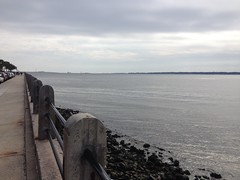
It was a big colder there, and I was out in the wind again, but it was still much better than Atlanta'd been all week.
I wanted to sit there for a while and take in the view, but there wasn't all that much to see. Way, way off there were 2 huge freighters. One coming in, another heading out. There was one guy in a private boat too. That was about it. I had a long way to go still too, and eventually my family would wake up, so I kept moving.
Well, actually, first, I did stop and take a photo of an old cannon from the median, then I kept moving.

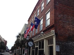
Around the east end of The Battery, heading back north, there were some really lavish estates.
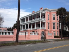
Like 10 or 15 of them were angled a bit too, so if you were driving south, you'd get a better view of the side facing the street, or if you were driving north, you'd get a better view of the "front" of the property. The shops were very colorful too.
Later, I noticed that whole area of town was labeled "Rainbow Row" on the map. I'd say that's a good description.
I tried to head over to the waterfront a few times, but it wasn't easy. There were several of these really old streets, paved with bricks and cobbles and big round rocks and whatever this is:
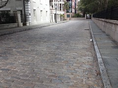
Not all that much fun on the road bike.
Eventually I got to where I could see stacks of containers and those big awesome cranes they pull them off of ships with. There was also this giant lot with some old facade propped up in the middle, surrounded by nothing. I stopped, found a good spot to take a photo of it, and it was at that point that I noticed that my iPhone's battery had died.
Great. Finally a ride worth taking dozens of photos of and my camera's dead. Seems like this happened about a year ago too.
Ehh. What are you gonna do?
I had a lot more that I wanted to see, and I wasn't going to bail on the ride because I couldn't take photos of it.
At the motel earlier, I'd read that there was a bike/pedestrian lane on the I-26 bridge over the Cooper River - the bridge that you'd take to the islands on the north side of town. Awesome! I'd hoped to be able to ride out to those islands, but I hadn't seen any even remotely convenient way to get over there, other than the interstate, which I'd figured wasn't an option. Turned out that the interstate was an option! Woohoo!
That devastating crosswind turned into a devastating headwind as I made my way up over the bridge though. Oof! It's like a mile up to the top and the grade can't be more than a few degrees but it felt like I was climbing Wolfpen Gap.
The view was spectacular though. Why, why did my phone choose to die 5 minutes earlier!? The bridge itself was a very artistic piece of engineering. The little marshes along the river were interesting from the above - water apparently pools up all over when the tide comes in, and flows back out of the marsh in little rivulets, not evenly. Several ships were docked along the wharf. Way off on the other side, there's this giant aircraft carrier and about 40 little sailboats appeared to be racing around some buoys near it. I watched them start and got to see them round the first one. That ship that I'd seen coming in from the Atlantic earlier was crossing under the bridge. I kept thinking "cool, I'll get to look right down on it", but it turned out that I was a little optimistic about my climbing abilities and it was long gone by the time I got to the top.
The first little island on the other side (or maybe it's a peninsula) was Mt. Pleasant. This struck me as odd, immediately, as I really didn't expect there to be a Mount-anything along the coast of South Carolina, especially not right up along the ocean, but there it was, Mt. Pleasant. And it was quite pleasant, in fact. It could not have been more pleasant, as I had to use the bathroom, badly, and there was a gas station right on the other side of the bridge.
I passed dozens of restaurants and a few neighborhoods. I rode up over Shem Creek. All the roads had bike lanes. It was great.
Somewhere in there the police were trying to route people around some work that the DOT was doing in an intersection, but nobody understood where to go, everybody was trying to follow their GPS, and a lot of people ended up circling to the right, through a gas station parking lot, and then trying to cross the same line of traffic that they'd been in a minute earlier. The gridlock was indescribable. People were pissed. It was nice not to be involved in all of that.
Eventually I made it out of town and into a little strip of salt marsh, driving directly into the wind the whole time. There weren't any birds in the marsh, just endless wavy grass and the cacophony of wind. There was this drawbridge though, and on the other side was Sullivan's Island.
If I remember correctly, The Gold Bug from Edgar Allen Poe is set on Sullivan's Island. Also, one of Kathryn's friends from high school lived on Sullivan's Island when she was a kid. I'd been there once before, visiting a friend of mine when I was in college but I didn't remember much about it. Turns out there's not much to remember; lots of houses, one little shopping center. Actually, Fort Moultrie is at the southwest end of the island, so that's probably interesting, but I didn't have time to check it out.
I'd kind-of hoped to find a stretch of road that ran down the beach, so I could ride along and see the ocean and watch the waves, but no luck there. I guess that makes sense. People want to see the ocean, so they build houses where they can see it all the time.
I passed a truck parked out in front of a store that had a bunch of bumper stickers all over it. One particularly prominent sticker said "Smile if you're not wearing any underwear." Just reading it made me smile, which I guess is the idea, but then I smiled again when I realized: "Hey, I'm actually NOT wearing any underwear." Heh.
Sullivan's Island gave way to Isle of Palms. From the little bridge between them I could finally see the fury of the Atlantic. There were some serious waves pounding the beach there, driven by the same wind that was making me work so hard. I'd been there once before as well, and from that trip I remembered that the currents between the two islands are super dangerous. There was even a sign warning people to stay out of them. Man! Cool stuff. Again, I wished my phone hadn't died.
I rode up and down the island for a while, hoping there was some stretch along the beach, but again, no luck. I had to settle for a look from a little bluff near a half-built beach house. Funny thing there... as I turned off of the road, the drive was solid at first, but then quickly turned to sand and I crashed. Ha! Fortunately it was sand that I crashed into. Unfortunately I got sand in my shifter and kept having to bang on it to get it to work, in either direction, most of the way back to the motel.
The trip back was uneventful. That terrible headwind I'd fought all day became a glorious tailwind. The DOT had finished whatever they were working on in that intersection and the traffic had unwound itself. Climbing the bridge was trivial in the other direction. The sailboats were still racing. I took Meeting Street back north and eventually crossed the tracks over to Rivers Ave. Meeting Street had a bike lane and seemed less exposed to the wind.
I was getting pretty hungry as I pulled up to the room. The girls were up but Kathryn was just waking up. Perfect timing. We grabbed some lunch at Fatz Cafe. If you go there, I recommend the chili and the chicken tenders, but especially the chicken tenders.
The rest of the trip was great too, but it doesn't really count as outdoor adventure, so it gets no telling here.
And, so...
That is all.
For now.


No comments:
Post a Comment