Adventure!
It's not exactly imminent these days, but it is at least now possible.
Adventure possible!
This past winter was horrible. Rainy days and long nights aren't conducive to improving one's fitness. Heck, even maintaining it. I'm probably not at an all-time low right now, but it sure does feel like it. I remember riding across the states of Georgia and Florida. I remember deathmarching the Canyon. Did I really do those things? Really? I sit here now, questioning whether a person can do things that I have actual memories of doing. I even have pictures.
Maybe I did. Maybe those memories are real. Maybe if I put in a little work they'll even seem real again.
Two problems though...
First, my road bike is busted. The return spring is broken in the right shifter. No new replacement shifter exists. Compatible shifters are 90 bucks on Ebay and they look as old and more busted than mine. My dad has a compatible shifter he's not using on my brother's old road bike though. Should have that in a week or so.
Second, my mountain bike is busted. I put new brakes on it and there's just nothing I can do to keep the front brake from dragging. Glen's got it right now. I ought to be able to pick it up later this week.
Two problems, one solution: hiking. I ought to call it "hiking" though, with the quotes, because I've asked real hikers to join me on my idea of a hike and they have declined to do so a second time. But fortunately there is a solution to that too. His name is Clark Neal. We seem to have the same sense of Adventure. Or, at least compatible senses of Adventure.
That's right, I capitalized that A. Got to pay it proper respect.
It was late Sunday morning when I showed up at Clark's place outside of Helen. I was running late because I had to find my compass and my shoes. They were both buried in this gigantic duffel bag in my closet. When I unzipped it, it smelled unused. I felt like that guy that neglects his dog. Walk your dog, jerk. It was awful.
I pushed through the guilt though, through the shame, got my gear together, and picked up Clark.
We made a quick stop at a gas station in Robertstown for some calories and I also ran to the bathroom. I only mention this because the bathroom door was exceptionally light and didn't have a spring on it. When I opened it to get out, it got away from me and whacked the toilet paper thingie. "Oops!" And the lady behind the counter joked: "Are you breaking stuff?"
Ha! I'd all but forgotten about gas stations small enough that the clerk can joke around with the one customer in the store. Oh man, it's the little things. It was going to be a good day.
From there, we headed off into the Wilderness. Literally, the Wilderness. I think it's the Mark Trail Wilderness. On the way in we passed several Jeeps. There'd been a Jeep festival of some kind in Helen the day before. A turkey flew across the road in front of us too, and a chipmunk ran across. It'd been a while since either of us had seen a chipmunk.
We put in at the day use lot of the Upper Chattahoochee Campground and got right to it. I wasn't exactly sure where the woods becomes the Wilderness but I was sure that in the direction we were heading, it wasn't going to be marked.
We bushwhacked along Henson Creek for a while, diverged a bit, picked up an old roadbed, and eventually crossed over the creek. The last time Clark and Suzy and I'd gone exploring, we'd ended our day right there at that crossing. On that day, it had gotten late and cold and we figured we'd pick it up a few weeks later or something. It's funny how quickly things can change though. That was over a year ago.
But now we were back at it. Lets go!
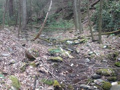
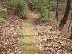
The trail was easy to follow. It looked like it wasn't too big of a secret either. Somebody had clearly been up that way recently. I had my GPS going, and as I do with all my little Adventures, I'd planned on putting the data on my trails site, but I kept waffling about whether to declare the trail an "adventure" trail or just "reclaimed". Usually if I declare something reclaimed, it's because it's pretty overgrown and you have to push through brush. This trail had very little of that, but a lot of deadfall. A lot. Seriously. A lot.
Sometimes the trail was a nice little bench cut. Other times it dropped down and crossed and re-crossed the creek over and over. Clark was all: "Man, who was it that thought it was a good idea to put a road here!?" No doubt. It was difficult to follow. In retrospect though, the terrain on either side was shot full of little draws and dry prongs. I guess they were taking the path of least resistance.
Some of the prongs weren't so dry though, and here and there remnants of old bridges still remained.
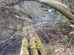
In some places the trail seemed to merge into the creek and disappear.
But, really, it had just diverted the creek, and with a little creative thinking we were able to figure out which of the many braided rivulets had once been the road.
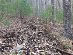
And we kept seeing signs of former passage. Disturbed leaves, partial footprints, fire rings... And then there was this impressive structure:
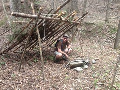
Ha!
I love finding weird stuff way back up in the woods.
The coals were still fresh. That fire might have been burning yesterday.
I'd failed to top off my camelback at Clark's place, so I filled it from the creek. There was a little pool there, right in front of the campsite. It looked too small to fish but big enough to lay back and relax in. The water was pretty cold though. Maybe later in the year...
We came to what we imagined to be a fork, with the left branch running up a little ridge. We'd been climbing steadily though, and the main trail seemed to keep going to the right, but downhill. Hmmm... The correct direction to go is usually up, but the well defined trail led down. Eventually we decided that we'd head off to the right, and if it peters out, we'd go back up.
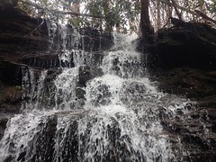
It didn't exactly peter out though. About 100 yards up it took a hard right across the creek and up the ridge on the other side. Why? Because, from that point, there was no other way to get over this:
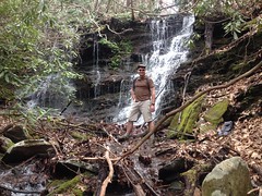
Woohoo! Waterfall!
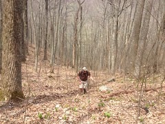
Clark got a photo of me by the falls too.
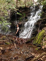
Kathryn says that I should have sucked in my cheeseburgers for the photo. Heh.
The old road managed to skirt that cascade, but then it led directly to this one:
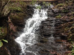
And there was just no getting up over it.
My guess is whoever built that road didn't do a lot of planning, they just headed upstream by whatever means necessary and backtracked when they got totally stuck. That's determination for you.
We whacked up over the falls and found the trail again. Apparently that had been it off to the left at that fork. We followed it up and around and up again.
It appeared to be going where it should though. Where should it go? If you look at the old USGS Quads, I think at 1:100K scale, they show this road following Henson Branch, then following Naked Mountain Branch, then curving south and eventually teeing into FS44F. Allegedly. The newer-but-still-pretty-old, higher resolution, 1:20K maps don't show it at all. The 20K maps aren't super reliable, and the 100K maps are even less reliable, but sometimes they tell the truth, and so far, so good.
It didn't look much like spring at the higher altitudes.
With the overcast sky and complete absence of leaves, it looked as bleak as any cold winter day.
The only signs of spring up there were little stalks poking up through the leaves.
Is this a Hosta?
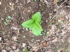
It looked like one. Kind-of. If it is, I'd never seen them in the wild before. Neither had Clark. Actually, I guess, we'd never seen whatever it is in the wild before, independent of whether it's a Hosta or not. They were everywhere. Every 10 feet, covering the entire hillside.
The old road ended abrubptly at a steep creek in a deep draw. This was perplexing. It should connect up with FS44F. We could see Cut Locust Gap above us, and 44F was up there somewhere, but we had a ways to go to get to it.
Across the draw though, there was another trail. But it sat at a funny angle, and it was much steeper than the one we were on. There was no obvious way to connect the two. A bridge between them would have required at least one 90 degree turn and/or would have sat at a steep angle downhill. It didn't make any sense. I've seen that before though - two trails that seem like they ought to have been connected at some point, but without any obvious means of having been. So weird.
Our best theory was that the steep trail was a skid. Trees were skidded down it, piled up in the draw and then taken out on the good road. If that were true though, it would have to have been built down from the top. Maybe we'd find an old skid network up there.
We crossed over and began to climb. Man, it was steep. Super, super steep. It teed into another trail and that teed into another, even steeper trail. We verified our position a few different ways and it looked like we were exactly where we were supposed to be, we just needed to keep climbing. So, we took the even more steep trail uphill until it blended into the backslope close to some unnamed gap west of Cut Locust.
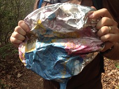
Somewhere up there we found the obligatory mylar balloon.
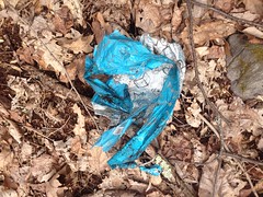
We'd experienced all manner of Adversity and made various interesting discoveries. The balloon was the last item on the Adventure checklist, and now we could check it off.
FS44F had to be up there, so we pushed uphill towards the gap.
It was a lot steeper than it looks. Like walk 20 feet, recover, walk 20 more feet, recover... That kind of steep.
Lo and behold though, when we got to the gap, FS44F was right there, right where it ought to have been.
There was a breeze blowing from the south, and there were ridges with ridges beyond them and more ridges beyond those.
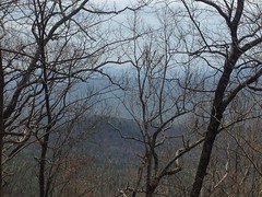
I think that's sort of to the south-west. If so, that's probably Hickory Nut Ridge in the way back.
We sat down there for a while on a couple of logs, ate a bit, and enjoyed not climbing. 44F was almost dead flat in both directions and in comparison to what we'd been doing, it looked like a lot of fun.
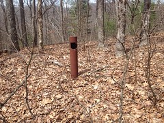
I keep calling it 44F, but I guess it ought to be called "Old 44F" as it has decidedly been demoted to the rank of trail. I'm not exactly sure where the Wilderness boundary is, but I'm pretty sure that the road is now inside of it. At the southern end, it's still marked 44F on a Carsonite post, but the pipe gate is long gone and there are big Kelly humps down there. I think the Mark Trail was actually designated Wilderness in the 90's, so it's been not-a-road for a long time now.
I waited until Clark had recovered a bit before bringing up what to do next. The car was to the west but to the east, 44F allegedly ties into the AT, and since I've never been down to the end of it before, and we were there, it didn't seem responsible to waste the opportunity, it would only add a mile and a half or so...
It was good that I'd waited because I'm not sure Clark would have agreed with making the hike any longer if I'd brought it up right after climbing up out of that ravine.
We got going again before giving our bodies a chance to get used to not going, and with no deadfall to climb over, brush to push through, or anything resembling elevation change, we made very good time to the AT.
We did get a little distracted though. There was a little pit full of old glass bottles off to the left.
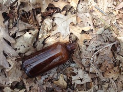
There was a nice looking mason jar in it that Suzy might have liked, but closer inspection revealed a jagged wound to the rim and we left it behind.
There was also this weird thing:
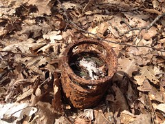
Clark thought it might be an old motor. Might be. It did have a bunch of copper wire wound up inside of it. It was a better theory than anything I could come up with.
Just past that was an old pipe gate. Right where the map said it should be.
And there were Trilliums everywhere.
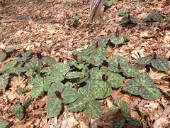
Everywhere! They even outnumbered those Hosta-things we'd seen earlier.
We reached the AT quickly, stood there for a minute, then headed back. There was a campsite right there at the end of the road, and there were a few odd artifacts lying about.

The German keychain wasn't all that odd. The blister pack of Nicoderm gum though, definitely fits in the odd category.
Clark: "Imagine trying to hike the AT and give up smoking at the same time. Seems like one challenge at a time might be enough."
Me: "Maybe you should chew it. Then later you'll be craving a cigarette despite never having smoked one."
Clark: "Wouldn't that be crazy - getting hooked on cigarettes by chewing the gum that's supposed to help you quit?"
He packed it out. Probably didn't chew it.
Near the southern end of 44F, someone had rolled out a glorious green carpet for us on the ridge between the old tire tracks.
The photo doesn't do it justice. It was super, super lush and fluffy in real life. Unnaturally so.
The Disney princesses were out there enjoying the woods too.
My pack was actually starting to get full. I'd accumulated a rain poncho, a bottle, and now two balloons.
We reached FS44 in good time, and trucked it back towards the car.
There was a little black salamander on the road somewhere in there.
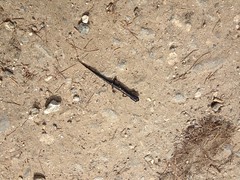
I'm not sure I've ever seen one that was totally black before.
The car grew ever nearer, but the map I'd printed out had several little dotted green lines on it. Dotted green lines mean: "I've seen what appears to be a navigable trail leading off in this direction." There was one such dotted line leading north along Wilks Creek.
Yes, I was tired, and my feet were tired and kind-of hurt, and the car was like a mile away, but we were right there, and it would be irresponsible... I'm pretty sure Clark didn't want to add any more distance to the day, but he followed me up that trail anyway. Thanks man.
The trail was well traveled. This made sense, there was an established campsite at the bottom of it. A ways up there was a little sliding falls with no good vantage for a photo.
And further up a spring had apparently popped up above the trail and turned a long section of it into a creekbed.
And above that, there was more trail. I must admit that I was disappointed to find more trail. I honestly didn't feel like following it. Clark didn't either. He was like 100 yards back, making less-than-deliberate progress toward me.
"The trail keeps going up there, but honestly, I don't feel like following it."
"Yeah, my wanderlust has been sated."
Mine had too.
Fortunately it was all downhill from there, and our jibber-jabber made the mile or so back to the car fly by.
I was a little disappointed not to have seen much wildlife except out on the main road. That's bear country up there and dangit there ought to be bears somewhere. It's possible that our persistent clever-banter scared them away. Maybe that's good though. You know, save something for next time.
My Adventure skills were a little rusty all day too, and that kind of sucked. My legs are a little more scraped and shredded than was once typical for the same kind of hike. I poked my hand on something. Got my camelback hung up once... Get it together Dave, get it together.
Back in Helen we grabbed some dinner at La Cabana. Suzy had been hiking with her sister at Arabia Mountain all day, but she'd made it back to town and she met us at the restaurant. We had a great time. Man! It's been a while. Too long, too long!
That was yesterday. Today was decidedly less adventurous but about equally strenuous. My father-in-law and I'd begin some driveway repair on Saturday and I spent the day today pulling off the forms and backfilling behind the patched sections with gravel/dirt/rock/cement and spreading the remainder of the gravel to cover a parking area near the top of the driveway... in the rain, no less. Three days of good, solid labor. My back is tired. My legs are tired. It's supposed to rain all week, and that's fine with me. I'm looking forward to getting some nerd work done. I hope it's sunny in a week though. I ought to be ready to get back at it then.


No comments:
Post a Comment