I've heard that with the advent of the Trans North GeorgiA, the Pisgah Traverse, The Allegheny Mountains Loop, and whatever Karlos is calling his route from Key West to South Georgia, people have been working on stringing bits of those and other routes together into some kind of Eastern Contintenal Divide Route.
I'd love to say that I rode that last weekend, but no, not even close!
Long before that thing I referred to above was even remotely considered possible, Jim Parham wrote of an Eastern Continental Divide Route in his volume of "Off The Beaten Track." Actually I'm not sure he had "Eastern" in the name, and I'm too lazy to go check the book. Anyway, this route was named so because it takes you up over the Blue Ridge at Unicoi Gap, and then back over it at Indian Grave Gap. To the north of that ridge, all rivers eventually flow into the Gulf, and to the south, all rivers flow out to the Atlantic seaboard. Or something like that. When you're riding it, you can't tell, but the route needed a name and I guess that name seemed like a good one at the time.
I rode THAT Eastern Continental Divide Route this past weekend.
I parked north at Helen at the no-camping here campground where Martin Branch tees into the Chattahoochee and immediately faced the first challenge of the day.
I'd brought with me: a base layer, wind shell, bib, arm and knee warmers, gloves, socks, shoes, shoe covers, glasses, and a helmet. I had forgotten, somehow, of all things, a jersey. This has never happened to me before. I have forgotten just about everything else, but never a jersey. The temperature wasn't an issue. I knew the base layer and wind shell would suffice. The lack of pockets though, that was an obstacle. Thinking back, it seemed like I'd raced 6-hours in the base layer before, and ridden the entire TNGA in it... But I'd had shorts with a pocket back then, and during the TNGA I had a backpack. Hmmm....
The solution did occur to me though...
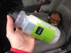
I stuffed everything I could in one of my water bottles:

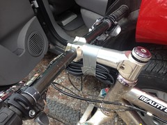
And taped the spare tube to my stem.

That should do it.
I'd have to stop if I wanted to eat something, but I could live with that. I didn't need my arm warmers yet, but they fit comfortably, folded up, under the legs of my pants. If I wanted to stash the jacket, I'd could stuff it into the back of my bib. I know just about every water source in the area and what's uphill from it, so I ought to be alright if I needed to tank up later. I couldn't effectively bring my iPhone with me, so I wouldn't be able to take more photos, but that was really the most significant cost of the solution. All right. Crisis averted.
Onward!
I climbed FS44 up past the first couple of turns, feeling pretty good. Better than I had for weeks, in fact.
When I got to Jasus Creek I felt good enough to give it a try too. There were a lot of trees down, but it turned out that I could hop most of them. There is so much wildlife back up in there, but I found myself hoping that I didn't see anything interesting, for lack of a camera. The way my luck usually goes though, I figured I'd see a sasquatch petting a mountain lion, both posing for a photo. Fortunately though, there were no sasquatch, no mountain lions, no deer, bear, pigs, or anything at all. I saw a single turkey print, and nothing else.
Or, at least nothing else on Jasus Creek. I did see a little mole hanging out at the edge of the road at some point after getting back on FS44. I kind-of wished I had the camera for that, as I've never seen a mole outside of my backyard before, but all things considered, it wasn't that big of a missed opportunity.
I didn't struggle much, but it wasn't an easy climb. I didn't feel strong and fast, like I was making good time. My heart rate was low. My legs felt like they'd give out if I picked up the pace enough to keep my heart working hard. My equilibrium was off. Still is, I guess. More climbing! That's what I need.
On Wilks Creek I got a really good view of the waterfall there. It's super hard to see in the summer. I was surprised how clear it was the other day.
I could also see more of what appeared to be old rails or skids on the other side of the creek. They were also difficult to discern in the summer, but super easy to see now that the leaves are gone. I'll have to do a little more exploring up that way soon.
But first things first. Back to the climbing!
The switchbacks weren't too bad. I didn't have trouble with them, but I found myself wishing that I was breathing harder.
There were some kind of weird semi-permeable drawstring bags tied around the ends of some of the hemlocks up there. The heck? At the time, it seemed like I'd seen that before, somewhere, but I couldn't put my finger on when or where. Maybe there, actually. Who knows?
Near Unicoi Gap there's a small sliding falls at the edge of the road, with a concrete settling tank built into it. The pipe was pretty badly clogged though. Water barely trickled out. I wondered how long ago the tank was built. It was a good source though, so I topped off my bottle, just in case.
With all of the leaves gone, I could see the old campground below too. I'd looked for it several times during the summer and couldn't find either it or the road leading to it. The campground sits further down the hill than I thought, and it turns out the road to it leads down from the intersection of FS44 and the highway. I'll have to go check that out sometime as well.
At Unicoi Gap I crossed the Divide and tore downhill on the road. It was a much longer descent than I remembered. Ones neck becomes quite tired during such a long descent. I had not remembered that either.
Near the bottom, I turned on to Indian Grave Gap Road and crossed the creek. I managed to get my right foot a little wet, but the shoe cover seemed to keep the water out of my shoe, somehow. Or, at least, if any leaked in, I didn't feel it.
That climb was a grind and a half, at least up to the little gap by High Shoals Falls. From there on it wasn't as bad, but I wouldn't call it good. My legs were getting tired and my toes were getting cold.
The potholes were all frozen. Enormous icicles hung from the rock on the left hand side of the road. I'd have liked to get a photo of that, but I have dozens just like it. No big loss.
At Tray Gap (or near it, at least) I had the option of hanging a right and descending back to the car, or hanging a left and descending a much longer route back to the car. It was officially dark at that point, and though I was prepared with lights, I didn't feel like being out any longer. More than anything, my toes didn't feel like being out any longer.
Right it was.
I forget how long Tray Mountain Road is, but it's really long, and it's also really steep. It was a blast tearing down it with just the headlamp. I think it might have been the fastest I've ever gone in the dark. It was definitely the longest downhill I've ever ridden in the dark.
I recommend it.
The road back to the car seemed longer than I remembered it being, but I got there and it felt good to have some legs at the end, unlike the last couple of rides where I'd ended up crawling back.
The barbecue place was closed so I grabbed some of that Chili Colorado at La Cabana, as I am wont to do, and it was delicious. At a gas station in Dahlonega, some guy was trying to return $60 worth of smoking accessories without a receipt. The cashier couldn't do it without the owner's approval and had apparently had it with the customer. I walked in on: "I can't take them back! You'll have to talk to him directly! What part of I can't take them back, you'll have to talk to him directly, don't you understand?!"
Entertainment!
So, I accomplished my goal of "more climbing in the mountains" and overcame the Adversity of the Missing Jersey. I also got pretty cold and thus had the opportunity to really enjoy my little truck's heater. All-in-all, a pretty good day. Feels a bit like old times actually. If I can, I'll have to get a little more of that next weekend too.


No comments:
Post a Comment