Dangit, I'm developing a backlog again...
This was what? A week and a half ago? I guess that's not terribly long ago.
In keeping with the spirit of the past few weekends, I got myself up to "the mountains" weekend before last to "do some climbing in the mountains" again. This time it was the general Noontootla area, though actually, I never set foot or tire on Noontootla proper.
No, I started on FS42 instead, on Springer Mountain, just above Doublehead Gap.
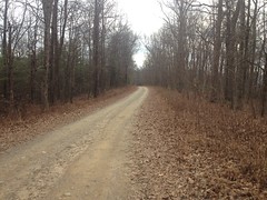
The weather was really nice. A little overcast, temps in the 60's, maybe a little breezy...
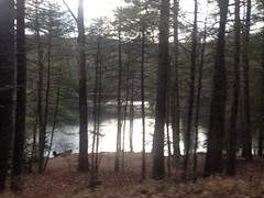
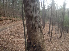
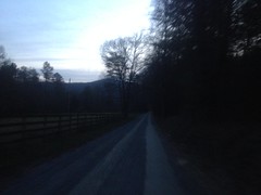
You wouldn't know it from the temperature, but it's full-on winter up there these days. No deciduous tree held a single leaf to the breeze. They were all on the ground, somewhere. You could see for miles into the woods and even further through them.
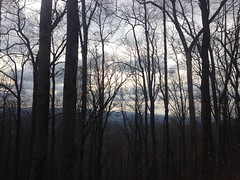
I wish there was a "mountains in the distance" app that lets you take a short video, then turns it into a photo, cropping out trees in the foreground. I swear The Brain does that for me because whenever I take a photo of what seems like a beautiful ridgeline, the photo is nothing but trees.
I climbed Springer Mountain, and I felt it a few times. My fitness isn't total garbage, but it's a pale shadow of its former self. I didn't feel as bad as I had in Ellijay though, so maybe that's progress.
I ran into another guy on a bike about 1/3rd of the way up. He was coming back down. I didn't recognize him, or his kit. I was wearing my old long sleeve Reality Bikes jersey. Little chance that would be recognized these days either.
I felt good at Winding Stair, but I had to sit back and climb most of the rollers along the ridge.
At Puncheon Gap the brush was dead to either side and I cold actually make out the path of old FS141A below, where it climbed up to the gap. I'd never actually noticed that bit of it before and I assumed it had been destroyed when 42 was cut. Apparently not though, unless what I saw was something new.
I took a detour there, up to the top of Hawk Mountain. Some guys were camping across from the food plot but I didn't see any Rangers in the vicinity.
I did see the aerial marker again, and for the first time, noticed that it read G23 rather than 623.
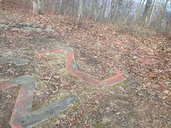
"G" eh? Ha! I've had that wrong for years.
I also noticed the footings for the fire tower.
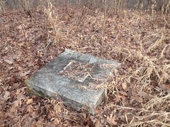
I can't actually remember if I'd seen them before. I knew there was a fire tower there at one point, but I'm not sure I'd ever looked for its footings.
I did notice that the singletrackish trail that leads back down from the loop up on top has become a full on jeep trail. I'd swear it wasn't as wide in previous years, but it's not impossible that my memory is off on that one. It was as rough as I remember though.
I'd forgotten what it was like to be able to see for miles into the woods and I kept getting distracted looking over the edge of the road. I didn't see any animals though, or anything that I hadn't noticed before. I kept looking though. I guess it had just been a long time since I could.
At Rock Creek Lake, I wished again for that "remove the foreground" app.
I almost went down to the shore, but I had that "keep moving" feeling and I kept moving.
The fish hatchery was as vacant as I've ever seen it.
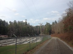
Just winter, I guess.
There does appear to be a newish road leading north from the property though, off into the woods. I checked my map when I got home and it's not on there. I wonder where it goes, and whether it's open to the public.
I imagine that Rock Creek Road must have looked much like Doublehead Gap Road before it became part of the Forest. If you use your imagination, there are indications that it was once settled everywhere you look. One such indication is a loop now known only as FS69C. It's about 6 miles long, and though I'd driven it in my truck a really long time ago, I'd never ridden it.
It seemed overdue, so I rode it.
It involved a great deal more climbing than I expected, but was otherwise unremarkable.
Well, I say that...
I did almost run over a little Ring Neck Snake.
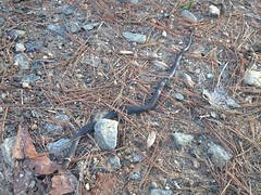
Thinking maybe I had, I spun back to see how it was doing. When I poked it though, it was kind of stiff, and I thought for a second that it had already died. But no, it was all pfft, pfft, 3 or 4 times, with its little snake tongue and it stretched out a bit too. Not dead, apparently, just chilly.
I also saw what I presume is a decent sized Shagbark Hickory.
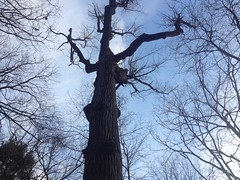
It was a little too far off the road to get the "fingers in the bark" photo, but the bark was deep and shaggy. If that's not Shagbark, I'm not sure what it is.
I saw a bunch of side trails too. I'll have to go run around back in there some day. Though, I think it would be better if that some day were after the end of deer and bear season.
FS69C spat me out across from the old church...
...and I hung a right.
This time I followed Old Rock Creek Road instead of riding all the way out to the highway, and it worked out well. The weather had been decent all week and it wasn't wet or muddy.
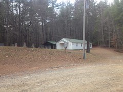
On Doublehead Gap Road, I noticed a memorial that I hadn't seen before.
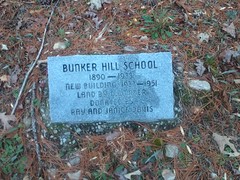
It seemed that the Fannin County Historical Society had been at it again. That's at least two markers on the same road. I wonder if there are any more.
Apparently there was a little school house there until the 50's.
This little building sits on the property now.
I wonder if it's the same building, or if the school house was torn down.
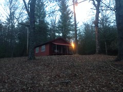
The light was fading fast as I headed west.
Fortunately I'd planned accordingly. Or, I'd tried to, at least. I had a set of commuter lights on the bike and my helmet-mount light as well. Though... I'd destroyed the red blinky tail light on a Silver Comet ride with Billy some months prior. Basically it had gotten so inundated with fine, wet grit, that the switch had gotten shorted, in the on position. It was impossible to turn off, and had drained the battery. I'd taken it all apart and cleaned it super well, but it was still stuck on. When I tried to take apart the switch itself, I fumbled a bit, and unleashed its spring loaded innards into every corner of my office. Actually, had the little parts flown into the corners, I'd have found them. As it was, I searched for like 20 minutes before realizing how hopeless it was and giving up. I'd actually tried that morning to purchase a replacement at the local shop. They had like 6 or 7 different lights, the smallest of which was about 5 times larger than my old one, and looked like a good candidate for getting bashed to pieces by my legs if I mounted it on the seat post, or kicked into my tire if I mounted it on one of the seat stays. So, this left me on Doublehead Gap Road, in the dark, realizing that I'd brought a working bar light, and a helmet light, but no tail light. After getting passed by one car, I figured it'd be better to have a white light flashing behind me than no light at all, and I put the bar light on my seat post. The next car gave me more space and I declared myself wise.
As I approached the gap, I also approached the Gilmer county line, where I was met with this friendly little sign:
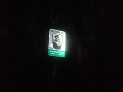
Mountain Bike Capital of Georgia.
All right then. I guess I was in the right place.
The crawl up 42 to the car was rough. I hadn't really bonked proper, but I'd definitely done something similar.
But, hey, that's part of it. Climbing in the mountains requires strong legs, a strong heart, working lungs, and a well tuned system of digestive organs. Tune yourselves for this, digestive organs! I'm counting on you too!
Yes.
And that was the end of that particular Adventure. I didn't have that good whole-body tired, but I was pretty tired all the same. I can feel it coming though. Maybe in a ride or two.
Maybe three.


No comments:
Post a Comment