Backlog number 3... This was last weekend as well.
Sunday, Sunday, Sunday!
I couldn't make it to Ginni's birthday the day before, but Sunday there was no big get-together. It was just another day. Staff would be running around working and guests would be out riding or eating lunch. Perfect!
So, I showed up at MGap at about 11:00 to wish her a belated birthday and we ended up hanging out on the couch for a couple of hours, just talking and talking about everything in the world. She told me a bunch of stories that I hadn't heard before. Oh, man it was great! Diane and Kate and Andrew were there too, so I got to see all of them. Eddie even showed up unexpectedly, with his classy, well manicured beard. I ate some authentic Mexican leftovers from the day before.
Ideal!
Happy Birthday again, Ginni! What are you now, 35, 36? Heh, heh.
That was my main objective for the day, but I did have some minor-Adventure plans as well. As one might imagine, the Mountaintown Connector trail connects the Mountaintown Creek Trail to the Bear Creek Trail. It's the one trail in the area that's not open to bikes. Well, to ride at least, you can push or carry if you like, but hardly anyone does that. And, as such, since I'm almost always there with my bike, it's the one official trail in the area that I've never been on.
No longer!
I would hike it, and if the powers align properly, continue on to Heddy Creek and see if the old USGS topo quads that show a trail leading up along it are accurate or not. Indeed, if I found a water feature of some kind, I would play in said feature. A grown man, alone in the woods, wading, swimming, leaping from rocks... Whatever play this feature permitted. Describing these plans to the assembled crew, Kate said it sounded like I planned to "frolic" in the woods. Yes. That was accurate. Frolic. In fact, that's how I should describe it going forward.
I parked at the foot of the Bear Creek Trail proper and proceeded north.
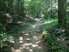
Funny... Given the dozens, perhaps even one hundred times I'd been on that trail, I'd only walked it once. Moving so comparatively slowly gave me a sense of urgency that took a while to shake.
I noticed something though, that one wouldn't likely notice on the bike. Beech graffiti, from 1982!
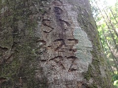
There was more graffiti on that tree, but the rest of it wasn't dated. I always look for dates when I run into that kind of stuff. There's graffiti on Stone Mountain dated to the 1800's.
At the Gennett Poplar, I figured I'd take the obligatory photo.
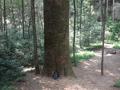
...but then, as I looked through the screen to take the photo, I noticed a weird, zaggity black line on the upper right side of the tree. The heck? I didn't remember seeing that before.
It was a snake!
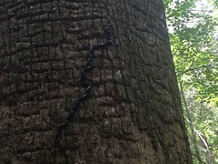
A black rat snake to be precise, climbing the bark of the tree. Goodness! First, I had no idea rat snakes climbed trees. Second, did it have any idea how high it would have to climb? It has to be 60 feet up to the nearest branch. Third, did it have a plan for getting back down?
I watched it for a while. It looked like it was climbing through a maze. It would stretch out the first 6 or 8 inches of its body and find some new set of ledges in the bark, then pull the entire rest of its body through the angles it had already twisted into. It was fascinating. I wanted to see how it ended. Would it climb the entire tree? What would it do when it got to the top? Would it fall? If it fell that far, would it die?
I had things to do, though, and while the urge to stay and watch was strong, the snake moved so slowly that I felt like I'd be watching all day and night if I tried.
Onward.
I was on the Bear Creek "Trail" and I needed to be on the Bear Creek "Loop" to get over to Mountaintown. There's a little cut-through though, that I had always assumed was closed to bikes. It didn't matter because I'd never needed to ride it, but as it turns out, it's not closed at all.
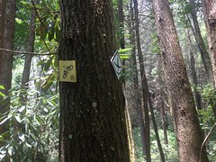
Ha! What do you know? When I got home, I immediately updated my trails site with that little tidbit.
The Mountaintown Connector though, is decidedly not open to bikes.
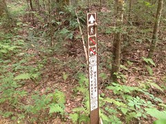
That may eventually change, as it's the only piece of the entire Pinhoti that isn't, but according to the CoTrails Asssessment, the lower half of the trail needs some serious rerouting before it could even be considered.
The upper half looked really nice though. Purpose-built, bench cut, rolling dips, grade reversals, half-backslope... The works. As I admired the construction, I saw a guy walking toward me, pushing a bike.
As I mentioned before, this is highly unusual. I've only even heard of people doing it who are intent on doing a Pinhoti thru-ride without skipping any sections. Everyone else rides out on Mountaintown before climbing back up the FS road and climbing a little bit of Bear Creek. I made a joke about him "cheating" by pushing over the ridge, rather than riding that aforementioned route, but it turned out he and his buddy behind him were staying at MGap and intent on following the Pinhoti, hike-a-bike and all.
They had another reason to be pushing too though. They were both from Tampa and not all that used to the local brand of rock garden. Consequently, by the time they were 2/3rds of the way down Mountaintown, they'd triple-flatted and had been walking ever since.
As fate would have it, I carry a little first-aid kit with me, most of the time. It's a bunch of stuff packed into a little snack bag. I throw it in my jersey pocket when I'm on the bike and I put it in one of the zip-pockets on my camelback when I'm hiking, or when I'm doing a long-distance ride. Since I use it on the bike too, it not only contains first-aid supplies for fixing people, but first-aid supplies for fixing bikes as well: glueless patches, tire boots, power-links, duct tape...
Mountaintown is remote. Except during organized rides, the likelyhood of running into another soul on that trail is low. Really, really low. The likelyhood of a hiker running into a cyclist pushing on the connector is even lower. The likelyhood of a cyclist running into a hiker, who just happens to be carrying supplies to fix a bike... I say this all the time: What are the odds? And I'm consistently surprised by how good they actually seem to be!
It took us several tries to fix the flat.
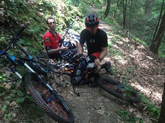
He had 3 holes in 1 tube and 2 in the others. We didn't notice the 3rd hole though until we'd already patched 2. I actually ran out of patches before we got it. Duct tape to the rescue? Not at first. Turns out you can't just slap a big piece of duct tape on a tube to patch it. No, you have to wrap it around a few times. It helps to wrap all of that with electrical tape too, which they had on them. That holds!
The tire was a little floppy where the tube wouldn't fully inflate because of all the tape, but it worked! They had originally planned on riding the Pinhoti back to MGap, but with the crippled bike, they updated their plans, substituting in various roads.
Did I mention that one of the guys was originally from New Orleans? He was. He was like: "When I saw you were from New Orleans too, I knew it was going to work out." How in God's name did he know I had lived in New Orleans? I puzzled over this for a few seconds, before finally asking him, almost those same words. He pointed to his forehead. Ha! My hat! Yes. That explained it. I forgot I was even wearing it. Working on bikes, it actually seemed to me I was wearing my helmet. Woohoo!
Anyway, when everything was fixed, I wished them luck, and they were off.
I was off too, in the opposite direction.
The lower Connector is a bit of a mess. It looks like someone wore in trail to connect a set of old skids. There was at least one spot where the old skid diverted the creek. It's not super, super bad, but it's definitely not good. You definitely wouldn't choose to put a trail there if you intended for it to last any length of time.
The Connector was fairly long too, longer than I expected it to be, but it did deposit me on Mountaintown proper, and I recognized the intersection.
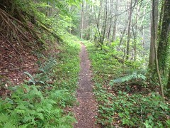
As I headed north toward Heddy Creek it started to rain. Then storm, then really storm, with thunder and lightning and a visibility-obscuring downpour.
It's amazing how the camera in my phone cuts through fog and rain.
I swear I couldn't see 50 feet in real life.
I found Heddy Creek and the old roadbed was easy to find too. It did exist. However, it alternated between wide open and clear...
...and so dense that you might think it had ended.
But, the overgrowth was always little sprigs of poplar, sweet gum, pine, or hemlock. Not magnolia. Not rhododendron. Never all that difficult to just walk right through. Except for the rain. The pounding, pounding rain. The walking shower.
I grew weary of the walking shower pretty quickly and resolved to return in late fall or early spring. I usually don't mind pushing through brush, but time of year makes such a difference, and given how far I'd already walked, and how much further I'd have to push. It seemed like a better idea to do it when it wasn't so difficult. Heck, at least come back when it wasn't raining.
The trail was interesting too. Clearly an old road. Surprisingly wide. Conventional wisdom would say that Nat and Andrew had it built it to pull out timber, but I wonder. It was built just up the backslope, leaving wide, flat land between it and the creek. And the creek there was wide and set down deep into the ground. It would take quite a rain for it to overflow its banks. I've seen communities laid out like that before, with the road running up a valley and houses and fields between the road and the creek. It's like that along Gates Chapel Road, for example, and Conasauga Road. Both of which lie nearby. I've wondered about Mountaintown proper too. It's also alleged to be an old logging road, built in the '30's, but it doesn't have the network of little spurs I'd expect for that. No doubt it was used for logging at some point, but I wonder if it started off life that way. It goes all the way up over the ridge at Buddy Cove Gap, and the other trails in the area connect over to communities that still exist today, to East Mountaintown, and Bethlehem. Bethlehem has been around since the early 1800's, since before any large scale logging. Trails ultimately lead from Mountaintown over to Jack's River too, which was inhabited all the way up Flat Top Mountain from the early 1800's, well into the 1900's - from before, through, and until after all of the logging. I don't know... Sure, logging, at some point, but I really wonder if that was their original purpose.
I pondered all of this as I walked back, in the rain. The pouring rain. As I approached the Bear Creek Trail, the rain let up, and it stopped altogether well before I got back to the truck.
The snake was gone from the giant poplar. I wondered if it had made it up to the top or fallen. I didn't see it lying nearby, so it may not have fallen, to its death at least.
My kit had even mostly dried by the time I got back to the truck, but... ha, ha! I had remembered to pack my little camp towel, so I was able to get completely, thoroughly dry before changing back into street clothes. High five to me for thinking ahead.
On the way out, I ran by Mulberry again to see if my Florida guys made it back ok. They had. They hadn't gotten lost on the way back. They were fine, and it was good to hear. I thought about hanging out for a while, but I actually had work to do when I got home, so I took off while it was still semi-early.
Goodness, what did I do for dinner? Teriyaki chicken strips at Shane's Rib Shack, I think. Yeah, that sounds right. I call it dinner, but I had it around 4. I remember being super, super, super hungry. I also remember feeling really sleepy later and pulling off more than once to get snacks, and more than anything, just to walk around. Mountain Dew and chocolate took good care of me though, and in the end, I made it home without incident.


No comments:
Post a Comment