Ok, number 2 in the backlog. Lets see... This was just last weekend.
Ah, yes. Last Saturday was Ginni's birthday and I even bought a ticket to the birthday bash they were having at Mulberry Gap, but rules are rules, and try as I might, there was just nothing I could do to make it work out. As much as I wanted to spend the day at MG, I was forced to make other plans. Dangit!
On the upside, I'd felt reasonably good all week. The previous Monday went by just fine. I was able to ramp my work schedule back up without any noticeable effect. I did have a persistent cough all week. It wasn't terrible, I just couldn't kick it. I had energy again, or at least more energy than I'd had, so I figured I'd better spend it doing something useful.
"Something useful" is relative, of course, and to me, it meant exploring "the Orange Blaze Trail" that I'd discovered on upper Dover Creek a month or two back.
The heat was formidable. It had hit 103 the previous Thursday, but it crept up a bit more that day.
Fortunately, as I drove north and climbed, it dropped a bit. It was still in the high 90's when the Horserange came into view.
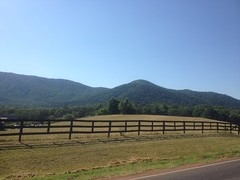
But it had dropped to about 93 when I parked at the intersection with upper Dover Creek. Balmy, in comparison.
Upper Dover Creek? Where is that? Well... Drive up the forest road past the Raven Cliffs parking lot and you'll eventually cross it. It's nondescript though, you'll need a topo map with names on it to figure out which creek is Dover, unless you know the area, in which case, you wouldn't ask "Where is that?" to begin with...
Anyway, there was once a railbed running along the creek and on the north side of whatever that FS road is, the old railbed appears to have been converted into a road, then eventually abandoned entirely, most likely when the Raven Cliffs Wilderness was defined.
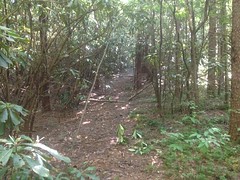
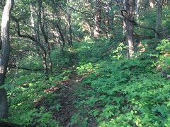
A few months ago the trail was wide open and clear. A week ago it was much less so. Kathryn would have hated it. I could easily make out where to go, but I had to push dangly brush out of the way pretty much constantly. There were a few really clear spots though, and several rhododendron tunnels.
So, it wasn't all terrible.
Last time, I wondered who used the trail. From the height of the canopy, I'd guessed riders on horseback, but I wasn't sure. That day, I saw some hoof prints on the road that looked like they'd come from the trail, turned right, and headed up toward White Oak Gap. So, I presumed that riders living in Kellum Valley made a loop out of it. Further up the trail, I saw more prints, and other signs of horse traffic too.
Ah ha. Mystery solved.
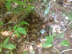
I saw signs of bear traffic too.
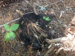
Or, so it seemed. Unless that wiry mess of hair also came from a horse, but I'm pretty sure it didn't.
I made quick work of the old railbed, and slightly less quick work of the old roadbed, or skid, or whatever it is, to Carr Gap. I'll tell you, when you start getting close to the gap, this time of year, unless you are just confident that the trail is there, you might decide that it wasn't. The weeds are so tall and dense, they completely crowd out the trail. The weeds on the backslope just blend right in to the weeds on the trail There's no indication of a bench. Nothing. You'd need X-ray vision to see it. It was pretty amazing, as just a few months back, it couldn't have been more obvious. Behold, the power of weeds!
On the west side of the gap, the trail is really easy to see and follow, at least for a while. it runs along the side of whatever that mountain is. Pine Mountain? Maybe. Whatever mountain it is, there's a ridge leading due west from it, and the trail turns and follows that ridge.
The ridge defines the Wilderness boundary, and either does, or once did define the Chestatee WMA boundary as well. There are signs all over the place. A good many of them have fallen down though. In some cases the entire tree they were posted to has fallen.
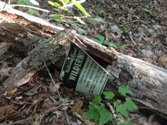
In other cases, the signs just lay on the ground as if the nails that held them up fell out of the tree they were nailed to. Must have been a dozen or more of them in that state. But, many others were still firmly posted, so it didn't look like someone went out there and removed them maliciously.
After a while, the old roadbed started getting further and further below grade, more and more full of leaves and deadfall, and more and more difficult to follow directly. It looked like whoever rode up there didn't follow it directly either. The woods to either side was pretty wide open, and the experienced eye could see where people usually go. The experienced feet could tell too, as the ground was a little harder there. In fact, a few times I could tell more easily by how the ground felt than by how the woods ahead looked.
It made me wonder about the road too. The trees didn't look like old growth, but the space between them did. Come to think of it though, I'm not sure what old growth looks like way up high. It might look just like that. I know that Dukes Creek, Dodd Creek, Dover Creek were all logged by either Byrd-Matthews or the Morse Brothers, but I'm not sure whether they made it over Carr Gap into the Kellum Valley. My copy of "Logging Railroads of the Blue Ridge and Smoky Mountains" doesn't mention Kellum Valley ever being logged, and given that it does mention the valleys to either side of it, it seems unlikely. There is evidence that there were homes in the Raven Cliffs Wilderness, and I've had a reasonably easy time making out what parts of it the logging rails ran up into. It's easy to chalk any old road up to logging, but this one runs high along the ridge, with no spurs. That just isn't how it was done. Old logging roads were placed along creeks so logs could be skidded down to them, then down along the creek to a mainline or a rail. This road may have served to connect communities.
Thinking about that made me question how far up Dover Creek the old rail actually ran.
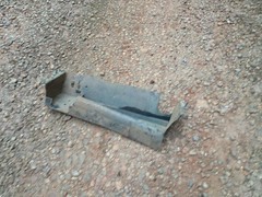
Anyway, I pushed west along the old road and found this piece of tornado-flung roofing lying up there somewhere.
As I approached the far western end, I checked the GPS pretty regularly. My map shows the NF boundary just east of Kellum Valley Road. I.e. at some point the trail I was on crossed out of the NF. Whether on to city, county, or private land beyond was anyone's guess, but I didn't want to walk onto it by accident. After all, who but locals would be coming from the direction I was? It wouldn't likely be signed. I'd put a few waypoints in the GPS to mark the boundary and I was vigilent in checking them.
And, then, right where I expected, I saw a bearing tree with a big red stripe on it, marking the edge of the Forest. The old road turned to the south there and I could even see a house in the distance. I know of a little side road leading up from Kellum Valley Road to a pair of houses. My guess, at the time, was that the old road I was on would just become that road, past the second house, and I'd probably be on someone's property if I kept going. Turned out though, when I got home, and looked more carefully at the lidar data of the area, the old road may actually parallel the new road and tee in below both of the houses. I'll have to check the property boundaries though. The road may or may not lie on someone's property, but in any case, it looks like if I follow it, I won't end up in someone's backyard. Might be something to look into in the future.
I didn't that day though. Instead, I just turned around and backtracked, all the way back to the car.
The Orange Blazes were a lot easier to follow in that direction too. It seemed that east was the preferred direction on that trail.
Still, it was slow going and rough until I started sidehilling below Pine Mountain.
Ahh, glorious sidehill.
On the way back down to the highway, I noticed a big chunk of someone's truck sitting in the road.
There's a hump in the road with a big dip on the other side, and it's easy to slap the nose of your truck on the far side of the dip if you hit it with too much speed. I'd done exactly that on the way up. It appeared that someone else had too, with much more disastrous results. Though, apparently not so disastrous that they noticed.
Pondering that gave me a sinking feeling. Maybe it was a chunk of MY truck. Maybe I'd knocked it loose earlier and I was Mr. Oblivious.
Aaahh!
So, I stopped and gave my truck a good once-over. Nope. Not me. I had all my parts.
Whew!
Coming back down the mountain I had to stop in a little turnout for something that escapes me now, but I happened to look to the right as I pulled away and noticed a little pile of dirt and gravel I hadn't seen before. Beside it lay several cut tree trunks, and as all this caught my attention, I noticed Mt. Yonah in the distance.
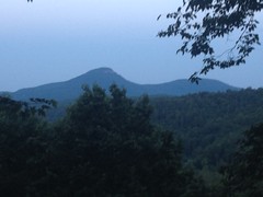
Whoa!
That's new. Or at least, new to me. Someone had turned the little turnout into a scenic overlook. I'm not sure what the dirt and gravel were for, but the tree trunks were what was left of what had been blocking the view. It's funny how you can go some place dozens of times and miss something so spectacular, every time. That is, of course, unless it's new. I guess it could be. Either way I was pleased to have seen it that day.
Dinner? I'm pretty sure that was the trip where I pulled into Rooster's Cafe in Dahlonega 12 minutes before closing time, and not only did they serve me, but they must have given me all the fries they had left. Woohoo! Score!
So, yeah, Rooster's. Good people.
Eat there.


No comments:
Post a Comment