This past Thanksgiving, my family and I visited relatives in South Louisiana.
It was a pretty good trip, all things considered.
South Louisiana is home to some of the best food I've ever eaten, and whenever I manage to get down there, I plan on consuming mass quantities of things like red beans and rice, jambalaya, fried shrimp and catfish, gumbo, blackened alligator, and so on. And, since it was Thanksgiving, I also planned on consuming mass quantities of things like deep fried turkey, plain old baked turkey, pork loin, homemade mac and cheese, bread stuffing, pumpkin pie, and similar.
With plans to consume so many calories, I also needed a plan to burn them. The road bike was the plan, or at least operative in it. 50+ mile days, every day, might do the trick.
I managed to do just that. Well, I did miss one day, I think, because of a wedding, but I'll get to that later.
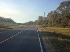
The first ride took me out of the neighborhood, along the initially quiet streets of Gonzales...
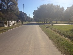
...out onto the incredibly busy streets of Gonzales. My goodness, the traffic. You'd think it was Black Friday already. After a few miles I managed to find some roads with more than an inch or two of shoulder, and the traffic wasn't a problem any more, but it sure had been for the first bit there.
I don't remember the highway numbers, but I basically headed east for a while, then turned north and crossed the Amite River...
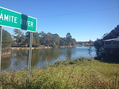
...near Port Vincent.
South Louisiana had recently been victim to a 1000 year flood. I.e. a flood so bad that such a thing only occurs once every 1000 years or so. It rained for weeks, and the storm was all hemmed in by various atmospheric pressure zones. The Amite, Comite, and Tickfaw Rivers overflowed and you were incredibly lucky if you didn't get at least 3 feet of water in your house.
We had lots of family, directly in the path of the flood, and by the most inconceivable stroke of luck, by and large, they managed to stay dry.
The residents of Port Vincent were not so lucky.
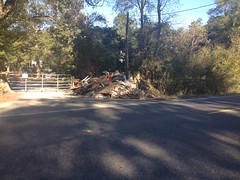
Every yard had a pile of debris in it, or a spot where it was clear that there had recently been a pile of debris. I felt bad. Like I was a disaster-tourist or something. Everywhere you looked there were gutted homes. A few had even burned. The irony.
I saw dozens of signs like this one.
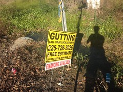
Professional gutting.
Yep, that's a thing.
Actually, my father-in-law was doing that every day. Either gutting or rebuilding. He'd been hanging sheet rock all week. His church coordinated a relief effort and they had a bunch of volunteers, he among them, doing whatever needed to be done. Thinking about that made me feel even worse. I was riding around, gawking at the disaster, burning all kinds of energy but not lifting a finger to help.
Terrible!
Up north of Port Vincent lay Colyell Bay.
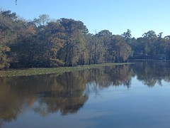
Unfortunately I don't have a really good concept of how all the waterways intersect up there. I think there's a creek that flows into the Amite and that little bay is part of it, but I'm really not too sure. I should study all that someday, I guess.
At the north end of my route I found the unmarked Satsuma Road, which led to the also-unmarked Hood Road.
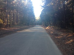
And there was remarkably little traffic from that point on, until I looped back around to the Amite.
I passed a really cool building on Highway 16 heading back toward Port Vincent. It was a roadside bar named "The Beer Box" (I think) and I can't believe I didn't take a photo. The whole thing was painted red. Just imagine a ramshackle roadside bar in South Louisiana, and you're probably imagining it correctly. There was an old abandoned prison bus across the road from it too. Why Dave? Why, no photos?
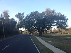
On another ride, I figured I'd head out along Manchac Bayou to the River Road and wander around down there for a while. So, I took a different route out of town, and passed a cemetery in Prairieville with some of the most perfectly iconic Great Southern Live Oaks I'd ever seen.
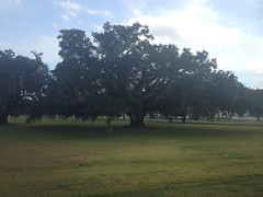
That's the tree I really think of when I think of South Louisiana. There are some massive Magnolias down there too, but Live Oak is what really comes to mind. They line every boulevard. They dot every park, playground, and campus. They're everywhere.
Apparently, Manchac Bayou Road is also called Alligator Bayou Road. I knew of both names, but I hadn't realized that they referred to the same road until I rode past it and eventually realized I needed to turn around.
And then I had to turn around again because it was decidedly closed.
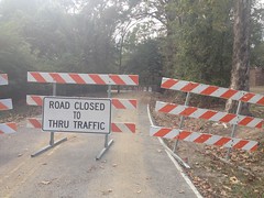
Not just one, but two layers of barricades. The second more formidable than the first. I guess the recent flooding tore up the road a bit. I'd have to come up with another idea if I wanted to keep to my plan.
Looking at the map, as the crow flies, it wasn't terribly far from my in-laws place to the neighborhood I grew up in, and before coming up with the Bayou Manchac plan, I'd originally considered taking a spin out that way.
So, that was my Plan B. I backtracked to Hwy 73 (Old Jefferson) and took it north to Baton Rouge.
BTW, there is no longer any discernible border between Gonzales, Prairieville, and south Baton Rouge. It's just a consistent density of neighborhoods and farms from one to the next. There is a unique bridge over the Amite that I swear was wood-planked when I was a kid, but other than that, no discernible border.
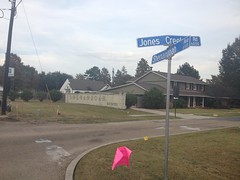
Tiger Bend Road is a 4 lane highway now, and Jones Creek Road was presently being widened into a 4 lane highway.
I passed some familiar sights.
J's neighborhood. The strip mall that used to house The Bicycle Source. The first gap I ever ollied. The church where I slid my first handrail. The curb I learned to do blunt-slides on.
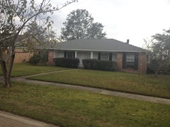
My old house.
Hickory Ridge Boulevard.

Man, it really looks like a boulevard now, with sprawling oaks that shade the grass to death and the street has been paved over so many times that the curbs are getting short.
I had to kind of burn it down to get home before dark that day. I remember it getting dusky on me before I even rode out of my old neighborhood. I had commuter lights on the bike though - red flashy in the back and a solid white up front - and I made it home safely, despite the traffic.
I did a couple of rides through Geismar to the River Road and around and around down those parts.
There are a bunch of robot cities down there.
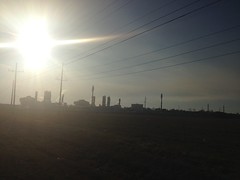
They inhabit a myriad of enigmatic vessels such as this one.
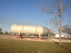
And the robots live in placid solitude. The surrounding roads are quiet as can be. I guess most humans prefer to avoid contact with them.
On one of the rides I made it to Carville.
I remember Carville as being where I'd turn around when I rode south out of Baton Rouge in years past. It seemed funny that it was also where I had to turn around when heading north out of Geismar on that ride.
On that same ride I passed Ashland plantation too.
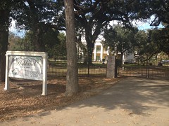
I've passed it so many times, but I've never been inside. Do they even give tours? It seems like they do. I think my kids got to go once. Maybe someday.
So, I did all those rides leading up to Thanksgiving, and one on Thanksgiving day proper, and I still don't think I managed to burn as many calories as I consumed. It didn't help that we had Thanksgiving day at my in-laws, and then another feast at my aunt and uncle's place in Covington the next day, and then also feasted at my cousin's daughter's wedding the day after that!
Fall and winter are always tough from a fitness perspective. Halloween, Thanksgiving, and Christmas. All feasting holidays. Christmas is coming up. It's only like 2 days away. Fortunately I'm broke, so I probably won't be doing all that much feasting this year.
Ahh yes, what happy fortune.


No comments:
Post a Comment