These last few months have been super hectic. Kathryn and I have both been working 7 days a week, 12+ hours a day. On the upside, we're getting semi-caught up financially. On the downside, there hasn't been a lot of time to do anything, together or individually. There's been even less time to write about the little that I've been able to do, so I guess from that perspective, it's fortunate that I've done so little.
Goodness, what a rationalization.
If anyone has been busier than Kathryn and I, it's Clark and Suzy, and their Unicoi Preserves business has been doing quite well because of it. I like that I can start typing "unicoi..." into the google search box and the second suggested result is "unicoi preserves". Ha!
Somehow though, through some monumental stroke of luck, Clark, Suzy, and I were all available on the same day, a little over a month ago. It was the weekend after Hurricane Irma came through, I think. Clark is overseeing the new trail work at Yonah Preserve, in Cleveland, and as such, wanted to get out there and see what kind of damage the storm had done. Preston, the guy doing the machine work, had reported that it was terrible. 30+ trees down on both loops. Yikes.
Suzy and I tagged along, and I managed to get a good sneak peak of the system.
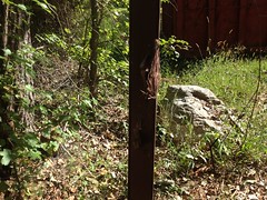
The front gate is off of Albert Reid Road. Eventually it will be open to the public, and the little road in will be paved. For now it's all dirt though, and gated.
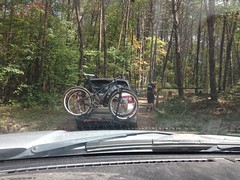
Of course, Clark had a key.
Past the gate, at the bottom of a little hill there was an old, abandoned house-ish looking building nestled under a monumental Sycamore.
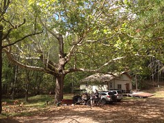
The building is due to be demolished, and they're going to put in some kind of parking area. Man I hope they can do it without cutting down that tree.
The trail led eastish from there and followed an old roadbed to the dam that creates the Cleveland Drinking Water Reservoir.
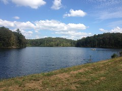
I tried to determine if the lake has some other name, but I couldn't find any.
I did find that it lies on Turner Creek, but not the same Turner Creek that tees into Town Creek to the north, nor any of the other half-dozen Turner Creeks that I know of. It's its own Turner Creek, distinct from those.
The dam is punctuated by a spillway.
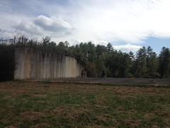
And the backside of the spillway is steep and scary-looking.
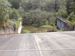
I hope some idiot doesn't ride under the chain and go tearing down that slope some day. I can't imagine it would end well.
There are various old roads running through the property. Most of them date back to the early 1900's, or at least I see them on old topo maps from around then. The whole area was apparently mined hydraulically for gold at some point. Later it was Camp Appalachian Wilderness. More recently, some percentage of the land was owned by the YMCA. Eventually the county got a hold of it. I'm not sure when the lake was put in. Clark knows a guy who knows the history pretty well. Maybe I'll get a chance to pick his brain on it some day.
We followed one of the old roads out to the most recently completed singletrack.
It was easy to spot. The bulk of the trail-building machinery was parked nearby.
At first, the trail looked great, aside from the kind of leaf and branch cover you'd expect in winter, rather than late summer.
We quickly ran into some downed trees though.
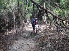
And then it was just one after the other, for the next two or three miles.
The trail crosses a feeder of Turner Creek at some point, and it's heavily armored to, across, and from the creek.
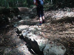
Man, that must have been backbreaking work. I think it's the longest stretch of rock-armoring I've seen.
The trail looked like it would be fun to ride without all of the downed trees. Twisty, bench cut IMBA flow. Unfortunately we didn't get to ride more than a few hundred yards at a time. Preston was right. Understated even.
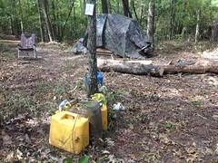
At the north end we took a little diversion off of the main trail over to a former primitive camp.
Legend has it that at-risk youth were brought here as part of a rehab-type program. There were various skeleton structures in the area, but making them habitable required a lot of work. They had to outfit the structures to live in, get the bath house, kitchen, etc. all working, and maintain it all without for some period of time.
It was all in ruins now.
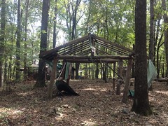

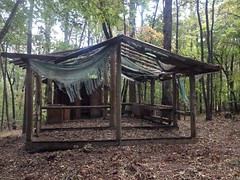
Though, I'm not sure it didn't look much different when it was in operation, at least when the campers would arrive.
The trail runs down to a point on the north side of the lake.

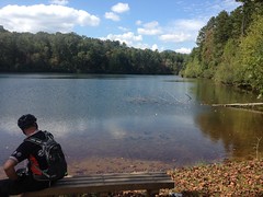
I love that you can actually access the lake from the trail. So often trails are built on land with gorgeous natural features, and the trail just winds around in the woods, avoiding all of them.
We hung out there for a while. There was an old canoe rack and various other remnants of the old camp scattered about. It looked like some locals had been fishing there too. I wonder if the lake will be generally open for fishing when the system is open to the public.
We finished the loop like an hour and a half or more after we started. That's how many trees were down.
We wanted to check out the other loop too, but the bikes just seemed like the wrong tool for the job, so we changed shoes and headed out on foot.
Actually, just me and Clark did. Suzy'd had enough Adventure for one day and headed back home.
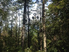
Right away, we noticed that someone had shot up the carsonite marker.
Classic.
Don't put up a sign in North Georgia if you don't expect it to get shot.
We quickly got into the downed trees too. There were a great many more than on the first loop. We'd made the right decision to go on foot. Way easier.
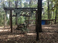
Several times, the trail crossed under various obstacles associated with an old ropes course.
In a few spots, I couldn't understand what you were supposed to do. I could clearly see the parts of the course, but how a person was supposed to interact with them was not at all intuitive. I remember thinking that I must have missed out as a kid. None of the camps I ever went to had anything that cool!
There were also dozens and dozens of old channels cut into the backslope. They were all somehow related to hydraulic mining. The various feeders ran water down from somewhere to some main ditch where it was directed into a pipe that blasted it at into the various draws, removing dirt and revealing gold.
It would take a monumental effort to make sense of them though. They ran every which way. It wasn't clear where from or where to.
Well, it was clear where to, ultimately.
The trail actually ran right past the head of the main gorge.
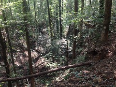
Sadly, it looks like nothing in the photo. In real life, it's striking. There was gold down in there once.
I realized later that I recognized the ditches. There are a similar ditches at Blanket's Creek, though not nearly as many. I know that there were 6 gold mines in that area (thus the town of Sixes and Sixes Road), but I was never sure whether the Blanket's Creek area was mined. Maybe it was.
So, I might have mentioned that there were a lot of downed trees. The root balls were particularly impressive on some of them.
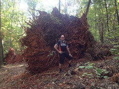
Particularly.
Somewhere back in there, there was an apple tree, and ripe apples littered the ground under it.
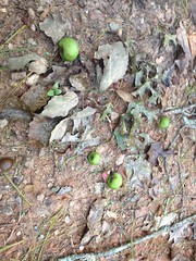
I wasn't brave enough to try one.
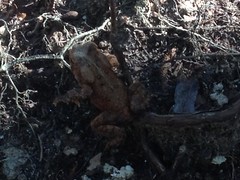
We found this cool toad too.
And this equally cool snake skin.
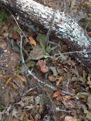
And that was about it.
Yep, lots of downed trees. One little section of trail looks like it'll need realignment too. Not too bad. Hopefully they can get some sawyers in there to clean it up and I'll get invited along on the ride to inspect that work too!
I'm not sure when the system is set to be open, though I'm sure Clark told me. The loops look largely finished. I can't imagine it will be terribly long from now.
We met Suzy back at their house, and we all ate at Bigg Daddy's in Helen. There was a band jamming outside on the patio, Clark and Suzy knew several of the guys in the band, and they hung out with us after their set. I ate some kind of enormous fried chicken sandwich with peach barbecue sauce on it. I highly recommend it, but I also highly recommend riding some epic loop beforehand to establish the 5000 calorie deficit necessary to justify it's consumption. I'm not sure what mutant chicken they made the sandwich out of, but I seriously want to see that chicken in real life. How can it even stand?


No comments:
Post a Comment