A few weeks back, hot off, a recent excursion to the general Nimblewill area, I was primed for more of the same. Ages ago, on the way to Bearden Falls, I'd seen a little spur off to the left that looked intriguing, but that I hadn't followed at the time. It had lain dormant on my map forever, and though I'd toyed with the idea of checking it out last time, I'd run out of daylight.
Not so this time.
On the drive in I ran across some manner of pheasant, which seemed completely ambivalent to my presence. Ambivalent enough that I was able to take a decent photo of it.
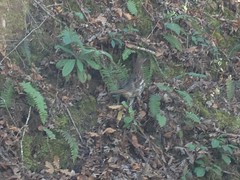
Decent, that is, except for being shot through the car window.
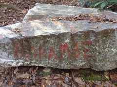
I parked off of old FS28E. I call it that. It was originally marked FS28C in the field, but there's actually another FS28C over by Turner Creek. The USFS GIS data calls is FS28E. But, no matter what it used to be, it's neither any more because the old sign has been pulled up, and it's been blocked off by Harambe Rock...
...and Marcy Rock...
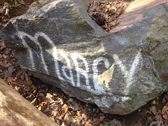
...and a few other rocks.
It's still very open and clear though.
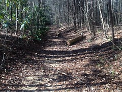
And it seems to get a good bit of traffic.
At the first creek crossing, it looked like people generally don't realize that they need to cross the creek, but then eventually figure it out. There were several tangles of deadfall between there and the next crossing too, with little route-arounds for each of them.
On either side of the second crossing were very large piles of dirt. They looked like mine tailings, but it wasn't clear where they might have been dug from. Gold would be the obvious thing to have been mined in the area, but there were no other indications of any such operation, nor had I ever read that gold was mined in that particular area. I'd seen similar piles along Alec Branch to the north, which I eventually decided were remnants of a logging operation, but upon closer inspection, these piles weren't as similar as I thought. They looked more like the slag heaps surrounding those furnaces in Pinelog. But, there's no iron in Nimblewill.
I was puzzled and decided to take some photos, only to discover that my phone had died.
Dangit! No more photos of this particular adventure.
I pushed up the trail, which was also quite well traveled. I passed some old campsites, and a large collection of "organized rocks". The rocks were piled up neatly. Lots of individual piles. It didn't look natural. I've seen similar collections before. Farmers clear their fields that way sometimes. Native American cemeteries have a similar look. I could stretch my imagination and think of a way it could have occurred naturally, but it seemed unlikely.
Wish I could have taken some photos.
Further up the trail branched and split and rejoined several times, and there were various little spurs.
It looked a lot like the network along Alec Branch. Routes, older routes, and even older routes, all eventually leading to Nimblewill Gap. It looked like modern FS28-2 is just the most recent revision of the same. No doubt logging was involved at some point, but it was tough to to discern whether it was the original purpose of the roads or not. I didn't see any evidence of habitation back in there. I did find a small sliding falls, but nothing spectacular. I did wish my phone wasn't dead though. It might have been worth a photo.
And, that was about it. Not a spectacular day. I did push a little harder and spend more time out there than usual, but it wasn't too tough.
There was only one more thing that is moderately worth noting.... During my previous excursion, I'd noticed what appeared to be a really well established campsite, and wondered if it was occupied, or whether someone had just dumped some stuff. Well, it was definitely occupied. On the way in, I noticed a family milling around the site, and truck parked nearby with two flags flying out of the bed. At the time, I was like: "Oh, ok, someone really is camping there." The truck was kind-of distinctive though, between the paint job and the flags. On the way out I noticed that it wasn't there any more, and figured they must have run to the store or something. Then, on the drive back, I stopped at a gas station that I often stop at halfway between Tate and Dawsonville, and I saw the same truck parked in the lot. It's not the nearest gas station, or if it is, then there's some back-way of getting to it that I'm not aware of.
It reminded me a little of Vonnie and his family. They used to drive up to North Georgia each summer and spend a week or two camped somewhere. They'd hike, fish, and ride, but also they'd visit the local towns and do all the regular stuff - see a movie, check out the restaurants... I remember him telling me that he would even take his daughter to the local libraries to read.
I know a lot of retirees do that kind of thing - RV'ing around the US. They were a young family though, my age. I always envied them a bit, that they could do that together.
Anyway, that's all. Not much else to that particular adventure. Doesn't even get a capital A.
Seems like I ate at Canyon Burger that evening. Grilled chicken with bacon and swiss on it.
Yeah, that's right! Man, now I want one of those for dinner tonight...


No comments:
Post a Comment