That last excursion to Pinelog on foot made me want to get out there on the bike again, so the next day, I did that.
There were a surprising number of other mountain bikers out there too. A guy was riding out right as I got there. Another guy was coming back in, and I ran into a couple driving out with bikes on the roof later in the day.
It had snowed the previous week and rained the week before that. Every trail in the world was closed and the gravel roads had been a mess until that weekend. I guess that could account for it.
I was keen to get in some gravel miles, but I also wanted to check out a couple of dots from my old topo map and see if anything still stood at those locations.
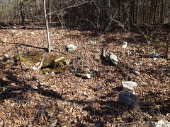
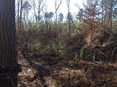
The first one was on Davis Creek. I parked my bike near the rood and walked all around back in there. I found the spot that the old structure should have been at, but nothing discernible remained.
Nothing old at least. I did find this tarp.
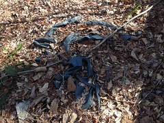
But I'm pretty sure plastic like that didn't exist in 1914.
Back at the road, right as I was about to jump on my bike, I ran into a whole family of squirrel hunters walking toward me. The grandkids took off into the woods, chasing after little flitting sounds and the dad kept an eye on them. I spoke to the grandpa for a second. No luck yet, but really they were really just out there to let the kids burn off some energy after being cooped up for a week.
I knew the feeling.
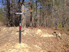
As I rode up the road, I noticed that the DNR had trenched and bermed every little side trail on the south side of the WMA too. But that wasn't all they'd been up to. At the second ford there were new road signs.
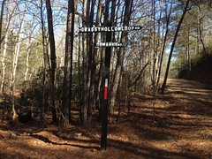
Donahue Road eh? They'd apparently renamed it. Dangit, all my maps would be wrong.
Grassy Hollow Road was now Grassy Hollow Loop. I climbed it, and really struggled up the steep chunks. The road was soft and climbing it was a wrestling match.
Near Grassy Hollow Gap proper there was a new clear cut too.
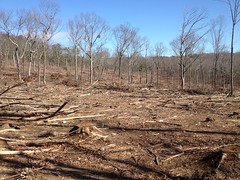
Quite a few of those in the last few years. Somebody's getting their money's worth out of the timber up there.
There was a new gate up the road a bit too.
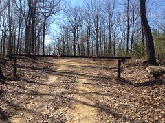
Brand new. Nothing had existed there in the past.
I guess the idea was to be able to close off the really steep sections. I've seen people get stuck trying to climb them when they're super wet, and when they're super dry.
I noticed what might have been a pit mine next to the road too.
I'd actually seen that one before. It didn't strike me as anything but drainage before, but being able to see well down into it and having seen a lot of similar pit mines since, it struck me as something this time.
It turned out that every major intersection had a new road sign.
The main gate had a sign on it too. Apparently the Grassy Hollow Loop starts at the south lot, runs up the (former) Main Road to the ford, follows Grassy Hollow Road to (former) Rock Quarry Road, hangs a right, and follows that back to the pavement.
I'd just ridden that. The roads weren't terrible, so I figured I'd do a left-hand loop too, up over Pinelog Gap and back on the highway.
I ran into another squirrel hunter near the gap. I'd passed his truck earlier. He'd apparently decided against pushing his luck with the soft road and parked halfway up the first climb. He was a mile or more from it, and looked like he was heading back when I saw him. Unlike the first group I'd run into, he'd had some luck - a couple of squirrels.
I'd had some luck too. I always say that there's no amount of not riding in the mountains that can keep you in shape for riding in the mountains, and I'd half-expected to have a terrible day. So far, it wasn't terrible though. The only trouble I'd had was with the soft roads. The climbing was fine.
There was another new gate somewhere on the north side of the gap. I had to duck under it.
Coming around the backside, I noticed all kinds of really colorful rock facing the old rail bed.
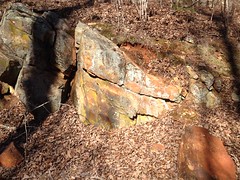
It's unfortunate how badly my phone washed it out. In real life, that lichen at the top is super blue, and that yellowish bit is super green. It's striking.
I took a few photos of a few things that I'd noticed I'd never gotten photos of before.
Some cuts that I presume were borrow cuts for building the Upper Sugar Hill Creek Dam.

This hole cut into the backslope might have been the basement of some structure.
Tough to take a photo of a hole. Even worse when it's overgrown.
There's a dot on the old map at its approximate location, at least.
I rode out past the lake, which was no longer frozen, hung a left on the pavement, pushed back around to White, and climbed Stamp Creek Road over Wolfpen Gap, back to the lot.
I always pass the Red Mountain Mine cut when I'm doing that, and though I always want to take a photo of it, I'm also always super tired at that point, so I'd always been like "yeah, next time..."
Well, it was finally "next time" and I got a photo of it.

Such that it is.
With all the renaming of roads, I wondered if they'd updated the map at the kiosk, so I checked that out.
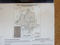
Yep. They sure did.
Back at the lot there was a guy with an ATV parked next to his van. The guy was deeply involved with something on his phone and didn't look up from it the entire time I was packing up. When he finally did, he just rode his ATV up onto his trailer and took off. I wondered if maybe he had been looking up regulations or something. ATV's are decidedly not allowed anywhere in the WMA.
Not a bad day. I had that good whole-body tired, but I felt better than I thought I would.
I'm a little anxious to ride some good trail though.
Come on, weather.


No comments:
Post a Comment