Goodness, we've been busy lately. We spent a week moving into a new house, then we had a french foreign exchange student stay with us for a week, then we spent another week moving in the last bits and unpacking... I've barely had time to think, much less write.
Before all of that, I'd just been exploring the area around my house. I'd always heard that there are trails around here, but never made a solid effort to find them. Turns out ther's lots of greenspace, and little scraps of trails through a lot of it. Strung together, they make pretty satisfying "local rambles" as I've been calling them on Strava.
In addition to the trails, I made some of neat discoveries during some of these excursions too.
For example, these are pulleys from some old machinery, just discarded down along some feeder creek of Nickajack.
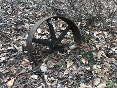
That one's broken. The one below is in better shape.
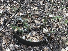
They were painted white at some point.
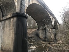
I eventually discovered a way to get down to the modern trestle over Nickajack Creek, near my (old) neighborhood.
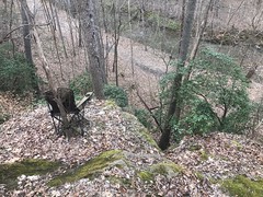
And, I discovered the semi-official trail system behind it as well. I say semi-official because, though it's not publicised anywhere, it's semi-well travelled, blazed, and even has an overlook, with official-looking signage:
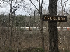
...an complimentary chairs.
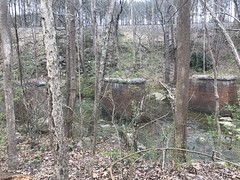
On sepearate excursions, I discovered even more interesting things along Nickajack Creek as well.
Apparently the sewer line used to be a railroad grade. An inactive trestle once lead tracks over from the side that the modern railroad grade runs along.
Isabel went to school with a local kid named Gary, and I eventually kind-of got to know his dad (Gary senior) and mom (Sheila) from seeing them at the local pizza place for years. They've lived here since they were kids and their folks since they were pretty young too. They also know a guy named Everett who really knows the area and showed them all kinds of obscure details.
For example...
When the tracks were first laid, they ran along this side of the creek for about 15 years. Then the railroad switched them to the other side, and they've been running on that side ever since. It's not exactly clear how far downstream it once ran though. I wonder if I can figure that out?
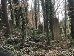
There are plenty of artifacts and local landmarks too...
This one is Turtle Rock.
Though I couldn't figure out what direction I had to look at it for it to look like a turtle.
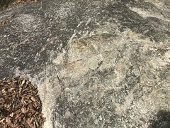
This one is Alligator Rock.
The pothole in the middle of the creek is supposed to be the nostril, and the eye is another pothole right up at the bank. The eye isn't super visible these days though.
At first glance, to me, it looked like the nostril pothole was the eye.
Either way though, it looks alligator-ish. Legend has it that the local Native Americans carved the ridges in the neck/body area, and closer examination does show that the stone was worked.
Neat!
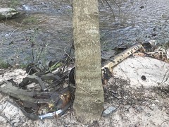
There's an old, abandoned, Dodge/Chrysler near Alligator Rock too.

And just downstream from there is another Turtle Rock, AKA Softball Rock.

On the north side, there's an old rock wall. I noticed it my first trip out there, but couldn't tell what was going on. It looked like a facade with some concrete structure behind it, but that's all that I could tell.
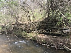

Turns out it was a swimming pool! It's completely filled in with sand now, but there was once a swimming pool down along the creek, fed by water from the creek.
The heck? A swimming pool?
Well, just uphill lie the ruins of Camp Highland, a YWCA camp that was in operation from the early 1900's until about 1960. Gary's mom went to camp there when she was a kid!
There are various photo collections online:
And a great story about a guy who's aunt went there as a kid.
I had to go back and check it out!
Getting to it is tricky though. In the early 1900's people apparently arrived by train most of the time. The camp sits right on the tracks. The trail would stop, passengers would get off, and that was it. Until at least the 60's, Camp Highland Road also led from Atlanta Road to the Camp. The subsequent construction of South Cobb Drive and East-West Connector broke up the north/east end of the road, and it now dead-ends onto the Glock campus. There was once a parking lot for the Camp where Glock's southern lot is, though it, and the old road have been bulldozed entirely out of existence. The camp, as far as I can tell, is completely cut off from the rest of the world. No modern road or trail leads to it. You have to just know it's there, and cross Nickajack Creek at Alligator Rock to get to it.
So, that's what I did. There's an old roadbed on the other side that leads to the tracks, so I followed that until I started finding things.
The first thing I found wasn't any part of the camp itself, but another old, abandoned car. This one was allegedly a Chevy.
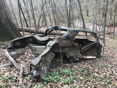

Not sure about the model.
Across the tracks, the old road became terribly overgrown, before disappearing entirely into the modern regrading for the Glock lot.
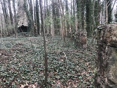
Walking south along the road, from the tracks, I discovered some tall footings on the right side of the road.
Some were toppled, but many were still standing. A wooden cabin would have sat atop them. There's an active 4-H camp near the Atlanta Airport that has a bunch of similar structures, still standing.
That particular cabin might have been the Arts and Crafts Building.
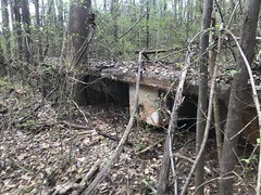
Across the road, on the left side was the Dining Hall - an impressive three-chimney structure.

There's an old photo titled "Main Building" in one of those collections that shows a smaller structure with a single chimney. The third chimney may have been that single chimney. The rest of the building may have been built off of the front of that building later.
There's a discernible loop through the grounds. It leads south from the tracks, around the Dining Hall, then hooks right and descends almost to the creek, where it hooks right again and climbs back up to the tracks.
The most discernible trail through the grounds these days continues past the dining hall though, past an abutment for an old footbridge.

When the car lot was built, on the other side of the tracks, this footbridge led from the lot to the camp, suspended some 20 feet over the railroad cut below. I could imagine it as some kind of final test for any would-be campers. If you were brave enough to cross the bridge, then you were cut out for camp!
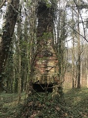
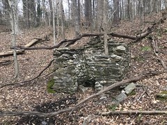
Near the bridge, was this old chimney ruin.
u
This was apparently the Infirmary. An old map shows it to be the Manager's Residence too, but I'm not so sure of that.
The trail bends around to the south past that chimney. There was once a large field there. At the northern end, they used to do archery. On the east side, there were originally teepees, then cabins, then eventually a swimming pool. In the south-east corner there were a couple of bath houses and a flagpole. On the south side was a two-story cabin for older girls. Along the west side were a row of cabins for younger girls.
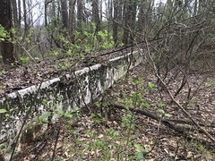
The swimming pool is almost completely filled in now, and the southeast corner of it was broken out at some point, but a good bit of it is still visible.


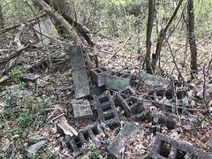
Here are the footings for the main cabins.

There's a basement behind them, perhaps for a storage room.

Someone restacked the cinderblocks for some purpose.

There was some evidence that homeless people have camped back there. Maybe it served some purpose for them.
The flagpole had recently rusted out and collapsed.
There are photos of it online still standing though.
One bathhouse.

Some grey-water tanks, I guess.

Another bathhouse?

This was confusing at first, but I later realized what it was - a latrine.
From there, the trail was less distinct, but it led around to another chimney ruin. This might have been the 2-story cabin for the older girls, or maybe the Manager's Residence.


There were more cabin footings across the road from it. This cabin may have been the one for the older girls.

There's a photo of the interior online, but you can't tell much from it.
Downhill from all of that are a couple more roads.
One basically spurs off of the main loop and runs around the perimeter of the camp, kind-of just behind everything. Seemed like maybe a maintenance road.
On that road, near the main camp, there was another cinder block basement.

Maybe equipment storage.
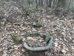
Way down at the end of the road, a little bit uphill, was the primary latrine.
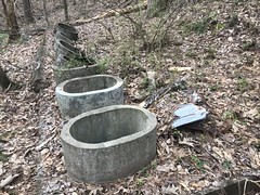
I wouldn't have known what it was except that Gary mentioned the vault and the 8 holes. After discovering this latrine, I recognized that other circular concrete thing that I'd seen earlier. This one was downhill, behind the pool, a good bit away from the cabins. I guess it's the high-traffic latrine, where everyone went during daily activities. The other one was right by the bathhouses, and much closer to the cabins. Smaller, but more convenient, especially at night.
There was also a large pit dug nearby, but a little ways away from the latrine itself.

It didn't look related. Strange.
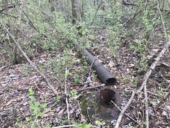
Kind-of in the middle of nowhere, halfway up the back side of the main hill, there was this well house.

It appeared to be built above a spring, and had lots of pipes running out of it.
I guess it was the main water supply, but it's hard to say. It doesn't seem offhand like it would provide enough for the camp, but maybe it did.
One of the old roads eventually ran along the creek and eventually blended into the general flat area next to it. It may have continued for some longer distance, but I didn't explore it further.
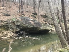
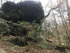
There were a few trails along the creek as well, one of which petered out after this big overhanging rock.
Another led west and continued further than I had time to explore that day. I know there's a large culvert under the railroad grade to the west. I'd seen it from the other side, and there are old photos of girls playing down by it, so the trail must have led at least that far along the creek in antiquity. Something to go back and explore, for sure.
Quite a find! It's amazing how busy it was for so many years, to now be so completely cut off from the rest of the world. And to think it's been sitting there behind my neighborhood for all of these years and I didn't know about it.
There are alleged to be even more sights to be seen along the creek - an old Thunderbird, some bear-claw marking somewhere...
Plenty more to explore!


No comments:
Post a Comment