It's been TNGA taper time for the past week and a half. No big efforts. Of course big is relative. What counts as a big effort? Does 50 miles on the mountain bike count? What if there's only 2300 feet of climbing involved? What if 2/3rds of it is on pavement? I hope that doesn't count, because that's what I did last Sunday.
There's this Beltline loop they're building around Atlanta. I'd heard about it for years, but never got around to checking it out. I'd heard it's unfinished. Some of it is paved. Some of it's still gravel. Some of it doesn't exist in any form. I downloaded a sketchy gpx file from 2007 that alleged to sort of follow it, and figured trying to make heads or tails of that would be good navigation training.
Saturday morning, I hit the road.

From the top of the hill by my house, the ATL looks like it's a long way away.
I took the most direct route too. Straight down Bankhead. Well, these day's it's Hollowell. But, if you ride down it, it still looks like Bankhead.
An observation... There are a lot of people on bikes, on Bankhead. Nobody looked like they were riding for recreation. You can tell who rides a lot. Sadly, that probably means that you can tell who lives nearby and either can't afford to drive or has a DUI. You can also tell who's eaten enough recently. Sadly, that probably means that you can tell who's homeless or enough of an addict that they can't afford to eat.
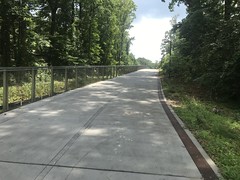
I picked up the Beltline proper in some random neighborhood near the Marta line. It was just sidewalks for a while, then it became some purpose-built trail.
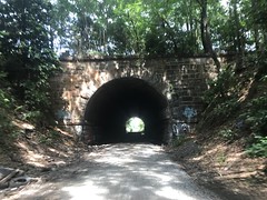
Every single bridge or tunnel was interesting.


If I'd stopped to take photos of all of the art that I passed, I'd still be out there. There were huge murals, random graffiti, sculptures, old buildings, you name it.
In some spots, there was plenty of natural beauty as well. Flowers with peach-colors lined the trail for about a mile, with cattails behind them.

It looked like the trail mostly followed an old railbed. "The Beltline" I imagine. In some spots it was marked, but yet unpaved.

Some sections were pretty remote. You could see houses and buildings through the woods, but nothing right up on the trail. In other sections, there were shops on either side. It mostly followed the old railbed, but about halfway around, it became a bike lane for a couple of blocks.
Somewhere in there, it went through the Krog Street underpass.

Ha!
I can imagine the meeting where they decided that.
Some guy: "Well, we have a couple of options here..."
Everyone else at once: "Krog Street!"
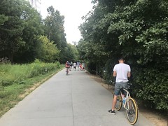
Where there were shops, there were people. I'd be tear-assing for miles, then hit some traffic, then back tear-assing again.
Somewhere near there, there were a bunch of chrome plant sculptures. I'm kicking myself for not getting a shot of those. But, again, if I stopped for everything...
The trail was a little confusing near Piedmont Park. It emerged on Monroe Street just east of the park, but then it wasn't clear where to go. It turns out you're supposed to cross the street, go right, and pick up this little unmarked singletrack off of the sidewalk, which gradually widens into a railbed. I guess. I ended up going through the park, finding the trail, backtracking to figure that out, then continuing on.
In the park, there was something going on. Tons of inflatables.

Whatever it was, it looked like fun.
There was also a reggae concert at the north end. Unfortunately, with the 105 degree heat index, only people that could bring their own pop-up tent were hanging around. There were surprisingly many of those, but the crowd wasn't huge.
The trail just got more and more confusing from there. I ended up on some side loop, before figuring out that the real trail was unmarked at that intersection. Then, I found the legitimate end of the trail.

It just becomes train tracks.
Some guys I met going the other direction confirmed that it was, in fact, the end of the line.
Wild.
I ended up taking roads out of town, refueling at a gas station in Midtown, and picking up what alleged to be another section of the trail in Buckhead. That section was also somewhat confusing and I ended up doing another side loop before figuring it out.
There was one spot where it went over a creek, and there was this huge snapping turtle just hanging out in the dead middle of the creek.

In the middle of Atlanta!
Eventually, I couldn't find any more trail. I'm sure there's some unfinished sections that I missed, but I think I hit everything that was paved.
When I got back to Bankhead, I remembered that it had seemed like one long downhill from my house to downtown, and I dreaded climbing back out at the end of the day. Turned out I had plenty of legs. I could tempo-climb the hills on Bankhead, and it didn't get tough until I hit the wall on Veterans, and I even managed that.
Done! Whoooo!
And, everything felt good. My pack, my shoes, my cleats, my grips. Everything. Last shakedown before the TNGA.
Here it comes.


NICE for giving a chance to share ideas for your comuty i really thanks for that great post.
ReplyDeletetools