That's right, "Lindsey", not "Lindsay". I never understood how Lindsay was the way that was usually spelled. Or, at least usually in my experience.
I was in Dallas again a few weeks back, visiting the folks again, and while I was there, my Dad and I made our way over to Tyler to hit some trails out there. It had been raining, just a bit, most days, for the last week, in the Dallas Metroplex, and while trails were open, odds were that there were patches of that horrible black mud here and there. We wanted none of that, the soil in Tyler is much sandier, and there were a couple of trails that we hadn't ridden in Tyler. I don't specifically remember why we chose Lindsey, but we did, and I want to say it was a Monday when we headed over, bright and early.
Tyler is like an hour and change from Forney, so it wasn't a huge production of a trip, but it was a nice drive all the same. We ended up taking some side highway most of the way and went through several small old Texas towns, which are always kind of cool to see.
I think it was a review on Trailforks that said that the park had the most horrific bathroom imaginable, or something like that. I was kind-of dying to see it, only to find it locked when I got there, and replaced by a couple of port-a-potties.

Must have been condemned between the time of that review and the time we got there.
On the one hand, I was disapponted, but on the other, what bullet did I dodge by not being able to go in?
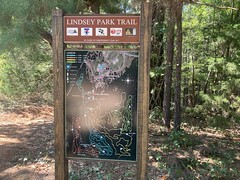
Quite often, especially with park trails, the trickiest bit of navitaion is getting from the parking lot onto the trail. Such was the case at Lindsey Park. There was a big, friendly map in the middle of a field...

...but it was well away from the bathrooms, well away from where we parked, and well away from the trial head itself. There was a bit of a hill all along a road across from the lot, and many breaks in the hill where people have walked over it in the same spot for a million years, but at first glance, there appeared to be half a dozen candidate trailheads. One of them was marked-ish, and looked like it might have been black-topped at some point, but up over the hill, it looked like it was either related to disc-golf, or maybe just an access road.
I forget now what, but around then I realized I'd forgotten something at the car, so we rode back, took care of whatever it was, and rode back onto the trail. This would prove disastrous later, but I'll get to that later.
We pressed cautiously on down the road a bit until we saw what looked like a proper trailhed, with a more proper map.
Excellent! Except that it showed "You are here" with a trail leading on a bit, then splitting, and you were supposed to go counter-clockwise. There was no split, and there was a field to the left, which appeared to be disc-golf-related.
Dangit, more of the same kind of confusion. How do you stay right if there's only one trail, and it's a left as it can be?
The only thing we could figure is that there must be a trail in that field that we just can't see very well, and we were actually past the split already, despite what the dot said.
So, we took the only obvious trail, and judging from the various obstacles we encountered, which seemed like they'd only be fun in that direction, it seemed like it was probably the correct way to go.
Another review, I think also on Trailforks, it was wherever that bathroom review was, declared Lindsey Park to be the best-flowing trail in East Texas. After riding a mile or so, I wasn't sure if he was being facetios, whether the trail got hit hard by the recent rain, and hasn't recovered yet, or whether it was, legitimately the best flowing trail east of Dallas, at least, and they're all just pretty rough. I mean, it wasn't bad, but the sandy ground was rough and loose, and it was rocky here and there. It didn't scream "flow" to me, especially when compared to Rowlett, or Squabble Creek (trails 3 and on), or Goat Island.
That said, those trails are pretty flat. This one had actual elevation. We'd climb for a quarter mile at a time and then descend for another quarter mile. It was pretty great. It kind-of reminded me of Allatoona Creek in Atlanta.
The first mile or so of Loop A looked like it got the most use of any of the trails. There was a shortcut at some point that let you do loops on it. The rest of the trail was decidedly less worn. I wouldn't say it flowed tremendously better, but it was less rough and sandy.
Well, most of it...
There were the skinnies:
I want to say there were 2 of them, parallel. Maybe. My Dad took a high line. I rode that, for like 500 yards. It just kept going and going. Down below was deep, loose sand. I guess people end up falling off or getting stopped and having to walk quite a bit.
Just after that, there were these old abandoned metal things.
I thought this one was a blind at first, but taking a closer look, it was too small.

I'm sure somebody knows what it is. Maybe I should post it on Reddit.
There was another one nearby, knocked over.

No idea.
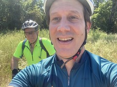
Some ways further on we had to stop for some reason that escapes me now. Look at us with our modern bikes.

We both rode the same bikes for like 20 years, and finally upgraded in 2019 and 2020. It's still surreal when I see them together like that. I still expect a Litespeed and a Fisher.
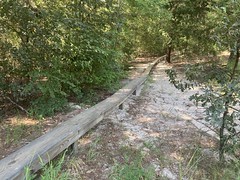
Loop B involved another extended ride on an elevated platform.

This one, thankfully, was properly wide.
While riding out on that one, I could see another one a ways off to the left. I expected we'd be on it in a bit, but we just kept making right hand turns. We even crossed back across a power line cut that we'd crossed before riding over that boardwalk.
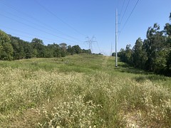
Eventually though, eventually, we started bearing left, crossed back over the cut again, and finally rode back across that other boardwalk.
I think this is us crossing back over the power line cut or something.
The rest of the trail was just more of the same marginally flowy, semi twisty singletrack. Almost 15 miles of it, actually. There wasn't anything treacherous, except for "The Drop Zone" which is literally 3 different wooden platform drops of increasing heights. It's funny, I drop off of foot-tall rocks all the time, and at Blankets there are 2 drops that are about a foot tall each that you end up hitting at 20+ mph just as a matter of course, but the shortest of the platform drops looks scary to me. I'm sure if I just rode off of it, it would be nothing, but it looks sketchy. We didn't ride them, FYI, just saw them from what we did ride.
It was really cool to ride a trail with rocks and some different kind of soil than the standard Dallas black dirt. And downhills! Legitimate, extended descents. Good stuff.
Did I mention that it was hot? It was pretty hot. Not punishing Texas heat. Not above body temperature, but mid 90's. We were drinking, for certain, and 15 miles later, we were feeling it.
Done!

All right! Another East Texas trail explored.
Then it was disaster time. Strava recorded nothing. Or, at least, only a very small bit. When I'd ridden out, realized I'd forgotten something, and ridden back, then lingered for a while, Strava thought I'd returned to my starting point, and had finished my ride, and it was sitting there, asking "Finished?" or "Resume?", and had been for the whole ride.
The whole ride!
So, I have no GPS data for the trails. I have no detailed record of having ridden it for posterity. No PRs. No nothing.
[shakes fists at sky]
Ahh, technology.
At least I have photos, and of course, the memory of the experience itself. I hear that the brain is pretty good at information storage and retrieval. Plus, I guess we have a good reason to go ride that trail again.


No comments:
Post a Comment