I've had Cherokee Bluffs Park on my list of places to explore since it opened. Maybe that was in 2016? Maybe even longer ago than that. The problem has always been that it's kind of out on its own, an hour or more from home, and there's only like 2 miles of trail there. So, it's never really been a priority. There have always been trails with more miles or much closer short trails. I've never been properly motivated to drive all the way out there.
Well, earlier this year, I finally got motivated, and as I was leaving the house, I got a phone call. I can't even remember what it was, but I had to stay and take care of it. Then, like 2 weeks later, I was in my car, about to head over and same thing - random phone call that I had to take care of. Two weeks ago, the day after I got back from Texas, I was also adequately motivated, and I got all the way out there.
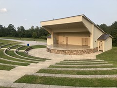
It turns out that it's a great little park. There's an amphitheater:
There's an early 1800's cabin:


There's a playground for the kids:

And a dog park:
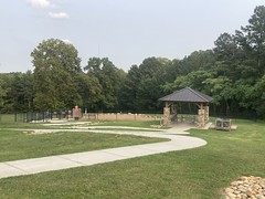
And pavilions for parties:

And,of course, what I was there for, trails:
The trails there are true singletrack glory.
The soil is just a bit sandy, but just enough to pack down into an even surface, not enough to turn into traps.
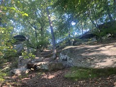
Almost immediately, you pass by all these rocks, that you can walk all over, or go down around the back side...


And there were allegedly ponds and a lake. I was really happy that I'd made my way out there. And then not 100 feet into the woods, my pedal broke off its spindle.


Classic.
It's like God just doesn't want me out there or something.
Last weekend it rained. Not all weekend, but enough, and I didn't ride at all. Instead, I got caught up on all kinds of nerdity. I called it "the nerdathon".
This weekend though, I was back over there, and it was really worth it. The main trail is the Bear Paw Loop, and it's extremely well constructed. Total IMBA bench cut, outsloped, half backslope, rolling dips, grade reversals, under 10%, switchbacks...

Lots of well-built bridges. Long lines of sight. It's really a great trail. You can really fly too, even climbing because of all the switchbacks. It's no problem seeing other people coming either, and that's good because there were a lot of other people. It appears to be pretty popular for hiking and running. I saw other tire tracks too, but I didn't run into anyone on a bike while I was out there.
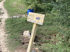
Dangling off of the north end of Bear Paw, right aftetr you cross a creek, there was a trail that wasn't on the map that I have. The "Biking Loop".
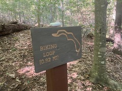
Ha ha! Additional trail.
Actually though, the creek right there has a good little rocky overhang that I felt compelled to climb down into and check out before cranking out more miles.


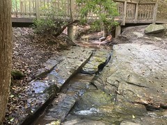
Oh yeah, that's some high quality nature.
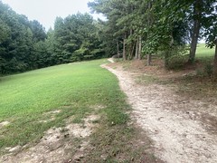
The Biking Loop was actually a bit narrower than the Bear Paw Loop and fairly technical. Like I'd call it half way between Intermediate and Expert. There was this one tricky rooty climing bit that I managed to pedal down into a rock and get stopped, but the downslope was super steep. I was already out on the outside edge, and when I put my foot down, it just kept going down and down. It's fortunate that I'm pretty flexible, because I ended up in quite a split before I could finally get my footing. I was worried for a second that I'd end up tumbling down the slope.
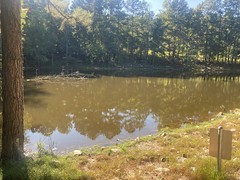
In addition to Bear Paw, there's another semi-main trail out there called the Lake Loop, that started off passing the Frog Pond:

Then continued under The Bluffs for a while.
When I stopped to take that photo, some people yelled down at me: "Are you all right?"
"Yeah, just getting a photo of the rocks."
I'm not sure what made it look like I wasn't all right...
Further on, the trail ran by the Dragonfly Lagoon...
...then wrapped around it over the dam...

...and around the back side.
There were so many trees cut down by beavers over there.
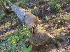
Do they just compulsively cut down trees? Like: "Oh, man look at that one! I gotta take it down!" Or do they think ahead? I mean, there's no way even 20 beavers could have moved that tree, and it just fell randomly along the shore. I don't see how it could have helped in any way. The branches were kind-of in the lake, so they couldn't even strip it for branches.
Weird beavers.
There was a bit of a maze of trails up to, around, and back down from the bluffs. One was kind-of stair-stepped, and it didn't look rideable at first, but I could see the line after looking at it a bit. I bet if I lived there and rode there, I'd figure it out and it wouldn't seem hard at all.
The Bear Paw Loop had a bit of an alternate outer loop with a bunch of connector trails that led over to Blackjack Road, and to a gravel road behind a neighborhood. I followed it to the end and ran into a bunch of new neighborhood construction. There was what appeared to be singletrack down below it, but I couldn't find a trail connecting over to it. Eventually I just whacked down to it. It wasn't exactly singletrack, but it was a trail, and it had tire tracks on it, so I followed it north. Before long it became paved, and before long I was in a neighborhood.
On the other side of the street there was a sign for the Birdsong Trail, which was more pavement, and led off to the north.
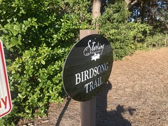
For all I knew, there were 10 miles of trail winding around that neighborhood, and I didn't have that kind of time.
Back the way I came, the trail was called Waterfalls.
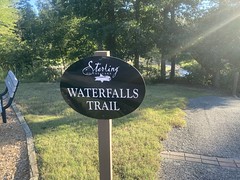
That sounded interesting, so I headed back that way to see if I could find any.
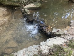
Yep. Well, more of a shoal.

Downstream a bit there was a beach.

And a little rock wall.
Much further upstream there was a proper waterfall.

It looks small in the photo, but that water is falling maybe 8 feet or so.
Continuing upstream, the trail became proper singletrack before merging back into the gravel road. It was just hard to see from the other direction because of some erosion barrier.
I spun out the rest of the loop, headed back to the car and took off. I want to say I rode like 10 miles total, which I guess is pretty good for a park that only advertizes about 3.
I thought about grabbing some local food, but remembered that Oglethorpe is on the way home, so I gave Sophie a call. She was already eating at the time, but needed someone to take a library book back to the Smyrna Library for her. What luck, I was in the area. I ended up eating at Jo's Grill, which is probably my favorite place over there. Their Maui Waui chicken sandwich is really good. I sat in front of the fireplace, which just had the pilot light on, but it's cool enough these days that I could feel it.
Fall is coming. I guess technically it's already fall. It'll be cool enough soon that it'll be cozy to curl up on the couch in the evening, or to sit by a fire.
I'm definitely looking forward to that.


No comments:
Post a Comment