A few weeks back, Billy texted me a link to a grand opening event at a new trail - Pumpkinvine, it was called. This rung a couple of bells. Pumpkinvine is a creek that flows out of the Paulding Forest. There's a gorge along the creek somewhere, that's allegedly pretty awesome, but I've never seen it. Also, unless it's a different Pumpkinvine, I think it flows north to the Etowah in Cartersville. There's an old kiln near it up on that end of it, that I checked out many years ago. Also, it seemed like I'd seen Brett Davidson post something about Pumpkinvine on Strava. He's heavily involved in trail building around the ATL. Same trail?
Turned out yes!
It was a brand new trail, and they were hoping to get folks out there to help wear it in.
There was a pretty good turnout.
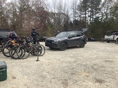
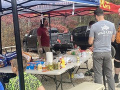
It helped that Brett was cooking burgers and hot dogs for everyone.
We spun a lap clockwise to start.
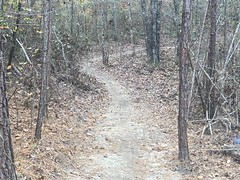
The trail was fast and fun. Or, I guess, it will be. I guess that I should say that it was built in a manner that should eventually yield a trail that is fast and fun. At the moment, however, it was super soft and bumpy, as might be expected, considering how new it was. About 7/8ths of the way around, we started running into folks coming the other direction. Apparently, while we were out there, they'd reversed the direction. At that point, we felt like we were so close to the end that it didn't make sense to turn around, but that may not have been the right move. There were like 40 people coming from the other way. We eventually made it out, hung out for a bit, then spun another lap in the other direction. Somehow the trail seemed a lot more fun in the other direction. I'm not sure if I was just used to it, or warmed up, or if it had gotten noticeably packed down by then, or if it just flows better in that direction, or what, but I enjoyed it a lot more on the second lap.
We noticed a bunch of old road crossings, and it looked like there was a trail leading along Pumpkinvine Creek itself, that wasn't part of the system. I'd be interested in going back and checking out all of that.
Back at the lot, Brett provided us with burgers, and we talked to the developer about the history of the area. The lot had the remnants of a vault toilet in one corner, and in another there were 4 telepohne poles sticking out of the ground, close together, as if they had once supported a structure of some kind. It turned out that the area had been used, for years, as a camp for at-risk youth. There were semi-permanent campers over by the toilets, and a couple of buildings skirting what's now the lot. There was a fence too, and the whole area was grassy. They used the old roadbeds to access the woods for hunting, fishing, and general adventure. Last year they had an opportunity to move to a better location, and the land became available. A local trail would be great for the local middle school and high school mountain bike teams, so they jumped on the opportunity to develop it.
When I got home to crunch the GPS data, I noticed that the aerial photos on Google Maps still showed the campers and buildings. You could even make out the fence. So, the transformation occurred pretty recently.
The trail was pretty good, if short. It's conveniently located near the beginning of the PaCO loop, and in decent proximity to Mt. Tabor. It ought to be possible to include it in a big loop.
We'll see.


No comments:
Post a Comment