In keeping with my recent determination that I need to spend more time in the woods, on foot, I went for another hike a few weekends ago. It was kind-of in the same area as before, but really a little bit east. If you check out the Lidar data for the upper Ward Creek area makes it look like there might be an old roadbed leading down along the creek from FS42. It seemed like a good thing to investigate, so that's what I did.
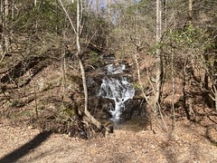
I parked at the little parking area on FS42 just east of Ward Creek, dressed appropriately for the chilly weather, and headed back west along the road, passing the little falls just north of the road on Ward Creek itself.
I couldn't immediately discern any old roadbed leading down along the creek, but I was eventually able to see where it switched back away from the creek, up toward the road. It didn't properly intersect FS42, as I guess it was built well before FS42 was, or at least well before FS42 was widened into its present form. Still, I was able to scramble down to it and see where it led.
It was a steep sidehill for a few hundred yards, but as it approached the creek, it hung a sharp right and pretty well followed the grade of the valley, keeping a steady distance uphill of the creek. Knee-jerk wisdom would declare it to have once been a logging skid, as it was pretty steep, and that switchback near the road was pretty abrupt. But... I always wonder about these old roads. Sometimes they just end halfway up the mountain, and it's clear that they were just there to get the timber down. But sometimes they keep going and going, usually up to a gap or to some other road. In this case, this one may have led up to some former incarnation of FS42. The relative flats just north of the ridge were populated throughout the 1800's, much as Gaddistown and Mt. Airy still are. If you lived there, and you needed to get down the mountain... If you were pulling a wagon, you'd probably have to head west to Cooper Gap or east to Ward Gap, but on foot or riding a horse, it would have been an ok route down.
Maybe. Who knows?
A short ways down I got tangled up in an old piece of barbed wire.

Ha! Glad my tetanus booster is up to date.
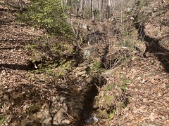
Notwithstanding lockjaw, I do love exploring old roadbeds this time of year. You can see forever, and it's always rained enough recently to make every little creek tumble.

The only trouble is trying to decide if some little cascade counts as a proper falls or not.

And it's even harder in retrospect, as I didn't have any good way of capturing the scale, and everything looks smaller in a video than it does in real life.
The road may be old, but it defintiely got some traffic in the 80's.

Here and there, it crossed the creek.

And there were a few side trails leading east up Hogback. I didn't notice any to the west up high though.
One of the spurs led up to some flats...
...where it ran across, dove back down toward the creek, then curled around into a sidehill and ended abruptly. It definitely struck me as a logging spur, so whether or not the Old Ward Creek Road was originally a logging road, it certainly seemed to have been used as one at some point.
Somewhere in there I found the first balloon of the day.

One of the side-spurs had also become a "crail".

Where it crossed a little feeder creek, the creek was shallow enough to jump the bank and eventually redirect itself down the trail.
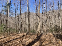
Here's a fairly representative shot of the trail. Really of all the trails I explored that day.

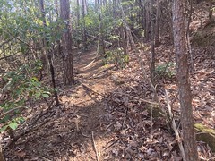
It wasn't hard to follow the bench-cut, but there was always deadfall to negotiate. Lots and lots of deadfall.
Balloon number 2:

Lower down, the old road crossed the creek again, and there was still an old bridge abutment on the uphill side.

Balloon number 3:

After that crossing, the road led sharply away from the creek to the west and sidehilled around the face of the mountain. It's not impossible that it kept going and I just missed the split, but the obvious route was to the west. It eventually led over and across a little feeder creek, that a much more substantial bridge must have once spanned. It actually took me a second to figure out where the road continued on the other side of the creek. Between the distance and some deadfall in the way, it wasn't immediately obvious.
I also got distracted by this little waterfall just upstream from where the road crossed.
Oh! Also, I almost stepped on this guy.

Banded Water Snake? Midland Brown?. I didn't uncover it to find out. With my luck, it would end up being an oddly colored Copperhead.
I love that snakes don't go into hibernation when it's cole. Rather, brumation.
They don't sleep.
They WAIT.
Balloon number 4:

And 5:

The road eventually ended at another road which led up and down the mountain. This one was wider and well below grade, much like the lower bit of Old Cooper Gap Road. It led up to another, larger flats, and had a good bit of rock stacked along the eastern edge. It looked like it had gotten a lot of traffic, over a long time. I wondered if it might be another Old Cooper Gap Road reroute, but after crossing the flats it just ended pretty abruptly. Maybe somebody lived up there at some point? Or, maybe the original route split off earlier and I just didn't see it.
Somewhere up there I ran into this 6-trunked tree.

It only looks like 5 in the photo, but there are 6. One is just hidden behind another one. It was hard to get them all into the same frame.
There was an old rusty bucket up there too.

Another spur led back down an adjacent ridge before blending into the backslope and becoming virtually indiscernible from the surrounding woods just above another old road, which led west.
Right away I recognized this waterfall.

Ha! The road I was on was Old Lower Conner Mountain Road (or so I call it). I'd been right there on my previous hike and been discouraged to find that none of its spurs led over to Ward Creek. Well, it turns out they actually do, but not directly, and certainly not intentionally. I guess it would be more correct to say that the spurs of one road end up intersecting the spurs of another. It's possible to connect them, but it's a circuitous path.
"Trail improves somewhat..."
When the trail started improving, I started feeling pretty confident that I was where I thought I was. When I hit the 6-way intersection at Old Cooper Gap Road, I was certain. From there, I headed up toward the gap, making sure to hit a couple of spurs that I'd missed the last time I was there.
There was an old canteen up there somewhere.

Rather than cross the landslide again, I just cut up to the road before I got to it, and from there, took the road back to the car.
It was still a little early though, and I had a good opportunity to check out something else... Some time ago I'd ridden the Hogback Mountain Trail, but I'd gotten to it by following the Old Hogback Mountain Road that runs up the east side of the knob from Jones Gap. When I first rode it in like 2004 or something, the road just became the trail, and then the trail disintegrated as it headed south down the ridge. Last time I rode it though, the road was overgrown and choked with deadfall, and didn't look like it got a lot of traffic. Rather than becoming the trail, it almost disappeared, then finally teed into a very well-defined trail. At the time I didn't feel like following it back north, so I wasn't sure where it led. I hadn't seen anything on the ride in, so wherever it teed into FS42 was not super clear.
I figured, while I was in the area, I'd figure that out, so I headed east along the road towards Jones Gap, keeping an eye out for any break in the rhododendron as I went.
Lo, and behold, there was a break. It was pretty high up the backslope and didn't look super-distinct, but it kind-of made sense, so I followed it.
And, pretty quickly I decided that whatever trail I was on was definitely not the trail I was looking for. It was definitely a trail. It was easy to follow, and there was a clear tunnel through the rhododendron, but there were many seasons worth of pine needles on the ground, and a bit of old deadfall that would certainly have been crushed with any amount of non-foot-traffic. Whatever... I figure that it probably led to top of the mountain, and from there I could find the trail I was looking for.
That was kind-of true. It did lead up the mountain, but not quite to the top. I ended up wandering around for a while up there before finding the real trail. When I did find it though, I took it back down to the north.
There were a few interesting things along the way.
An army sandbag:

Another army sandbag:

Some "organized rocks":

There were also many pits and piles. Mining? Old Ranger bunkers? Something else?
Balloon number 6:

And 7:

So many balloons.
The trail eventually led down into a little draw, and eventually became so covered in leaves that it was difficult to follow. When it teed into FS42, I looked back up the draw, and the trail was almost indiscernible from the rest of the woods. Also, it kind of teed in around a hump. If you didn't know it was there, you wouldn't know it was there. I'd bet that it's a little easier to see in the summer, but I'd also bet that with everything leafed out, if you don't notice it right at the road, you wouldn't see much looking up the draw.
Ok, now it was getting late enough to head out. I'd been out a satisfying amount of time, and my right ankle was starting to give me the business.
The road was totally in shadow from the trail back to the car, and with it getting late, it was also getting a little cold. It's always the ultimate conflict at the end of a hike (or a ride too, I guess). It's getting colder and colder, but you'll be done soon. Do you stop and spend time putting on another layer, or would that time be better spent hustling back to the car?
The ultimate conflict!
Back at the car, I noticed some weird green lump in one of the dried up ruts nearby.
Ha! Frozen frog eggs.


I've never seen them frozen before. Only the very outer bit was frozen. The eggs didn't appear to be damaged.
I cranked the heater and got dressed for the drive home. I don't remember much about it except that my right ankle was unhappy, and that I got the secondary shivers as I warmed back up.
It was a great day, but man, it's been a difficult winter. Pleany of Adversity, but nowhere near enough Adventure. Sitting here now, I barely feel like a cyclist, and I only feel like a hiker or explorer because I just wrote the above and I'm still riding high on the memories. Lets hope things turn around soon.


No comments:
Post a Comment