Pigeon Mountain is a long way away so this time I got up reasonably early and didn't feel rushed to get there. I passed some houses along Hwy 136 that, though not destroyed by the tornadoes, had clearly been damaged. There were no cars in driveways, and tall piles of belongings lay stacked in driveways and under front porches. I can only imagine what they're going through.
I rolled through Villanow and LaFayette, grabbed a soda at Uncle Jed's and parked on the north side of Dug Gap.
The cicadas were screaming. Has it been 7 years? I guess it has. Apparently they make two noises. One I was familiar with. I heard it all night, every night in Louisiana. That deep, oscillating, perpetual chirp thing. The other I'd never heard before, or at least never noticed. At first, I thought it was a distant tornado siren, then maybe that it was frogs, but then a cicada flew by and I heard it close up. I guess when ten billion of them fly around, it makes that droning siren noise. Wild.
They were flying around everywhere, and their corpses littered the ground. You couldn't look anywhere that you didn't see at least one.
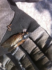
It was the great cicada plague.
But I hadn't driven all morning for ten billion bugs to get in the way. Time to ride. I followed the fire road up and around to the West Brow Trail (Cane Section) and out to the campsite at the end of the road there. While attending to the call of nature, I noticed two different species of Trillium.
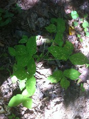
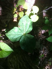
I'm pretty sure that top one is a trillium. If it's not, somebody tell me what it is. It looks trilliumish.
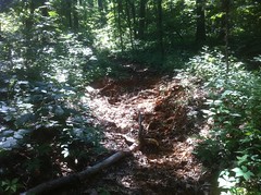
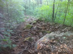
From there, the trail became singletrack. It was very technical, and there were quite a few trees down, but it was ridable and relatively fun for a while. I was crawling though, taking it really easy, picking my way through rock garden after rock garden.
At Walker Branch, I noticed a neat little canyon looking thing upstream, just off trail.
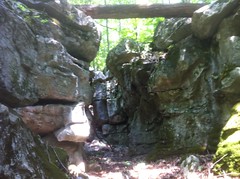
When it's wet, water must flow between the rocks. It was totally dry for me though. Up in there a bit, there was a scary chunk of rock balanced above my head.
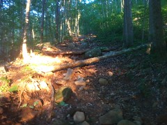
The trail eventually became a very long series of extremely rocky, chunky climbs...
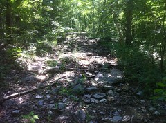
...and extremely chewed up and rutted out climbs.
It was like 95 degrees outside and every creek was dry, but somehow the trail itself was damp and soft. I walked, pushed and carried for at least half of the distance and at least 2/3rds of the time. It was all uphill, very rocky and very steep. I think it would have been more fun in the other direction.
At great length, I got to a 4 way intersection and took what I figured must be McKutcheon Springs road to the southwest. I have to admit that I was glad to be off the singletrack. I hoped that the Chamberlain trail would be more fun. I'd ridden it once before, 4 or 5 years ago, when it first opened. It was a blast back then.
It turned out to be more fun than West Brow, but not fun in the absolute sense. It was definitely interesting. The first quarter mile was fast and flowing with a couple of downed trees. Then there was this crazy (dry) creek crossing.

I remembered it from the last time and I'd half hoped that since then I'd have picked up some new skills and it would look ridable, but alas, I could see a line but I wasn't confident enough to try it.
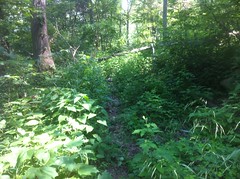
Almost immediately, the trail became overgrown and strewn with rock. It reminded me of the Hickory Nut, though even the Hickory Nut is generally clearer than this.
The overgrowth ended as abruptly as it began. I crossed several dry streams that tested my rock crawling skills. And, of course, I found a mylar balloon.
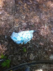
(I packed it out)
Near the end, I passed through a clear cut and at the absolute very end, a ton of thorn bushes that shredded my left arm, and for some reason, only my left arm.
There was a horse trailer in the Chamberlain Lot, but they must have been way up on the mountain somewhere. I hadn't seen them or anyone else all day.
It seems like I always forget something when I leave the car, and this time it was water. I mean, I had water, but I hadn't filled up my camelback and I just had whatever was left in there from last weekend, so I rolled up on Uncle Jed's and tanked up from their hose out back. I also ate a couple of chocolate donuts and starburst. High quality calories there.
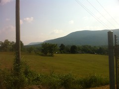
I had an idea where to go next. I've seen it on the map a bunch of times, but never been there: The Blue Hole.
The ride over offered a good view of Pigeon. I was up on top of that earlier.
The Blue Hole road was long and dusty.
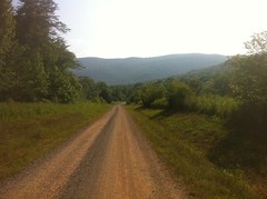
Cars drove past me in both directions. It must be a popular place.
When I got there, it wasn't quite what I expected. The Blue Hole, in all it's glory:
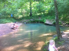
It was definitely blue, but also really small. I guess knowing there's a quarry nearby, I expected it to be an old quary that had hit a spring and filled in with water. I'm not exactly sure why. Maybe because I've seen it shown as a little blue circle on some maps and expected the circle to be to scale.
Still, it was a cute little swimming hole. There were a dozen kids and their parents hanging out along the edge. Nobody really wanted to get in the water though. I discovered why a minute or two later. The water had to be around 45 degrees.
Given how hot I was, it felt great, but I don't imagine it would have been all that great if you left an air conditioned house and rode over in an air conditioned car.
I stripped down to my bib and walked all around in the water. There are two distinct holes where the water comes up out of the ground. One of them was deep enough to get completely submerged.
Climbing back out, I managed to drag my shin across some little rocky ledge. My skin was numb though, and I didn't even feel it cut me.
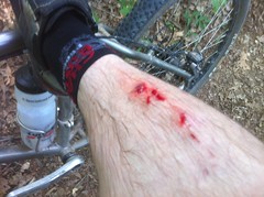
I only noticed later when I started to warm back up and felt the blood running down around my toes. It's amazing. I managed to get a classic bike wound, in the middle of a bike ride, but not from riding my bike.
I didn't see or hear any cicadas on that side of the mountain, but the holes they'd crawled out of were everywhere.
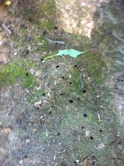
...and I do I mean EVERYWHERE. In a year or two, I should be able to randomly dig up a shovel-full of dirt from anywhere in North Georgia and find ten or twenty of them.
Refreshed from my swim, I had a point of confusion to resolve. The map showed a trail leading back up to the top of the mountain from the Blue Hole area. There were two, unmarked trails leading away from the Blue Hole itself. Neither looked especially bike friendly. I talked to a group of cavers about it. They hadn't been down either trail, but they were pretty sure that one of them went up to a cave with a deep rappel.
I gave the shallower trail a try, but after a few hundred yards, it was pretty clearly leading in the wrong direction.
I'd seen a nondescript, overgrown-looking fire road heading off to the right on the way in. Maybe that was it. Yep, that was it. It was overgrown for 50 yards or so, then opened up and except for a few downed trees and some extreme steepness, was a much nicer trail than I'd ridden yet that day. There were only a few sections that I had to walk and never for very long. It was about like Tibbs, if Tibbs had never been opened to ATV's.
Near the very top, I noticed the mouth of a cave. Ellison Cave, I later determined.
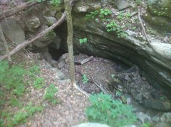
I think that's the name of the cave the guys had told me about earlier. I wonder if the trail leading away from the Blue Hole leads more directly to it.
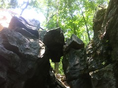
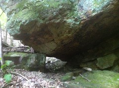
Nearby there was also this crazy balancing rock where a stream flows through the gap between the big rock and the one it's sitting on.
All that was right up at the top of the trail and before long I was back at the same 4 way intersection I'd been to at the beginning of the day. It was about 7:00 then. I had about an hour and a half of daylight left. I figured I'd descend the Pocket Loop and take the Estelle Mine trail back to the car.
The Pocket Loop looks like a long descent on the map, but there turned out to be a bit of climbing at the start. On the Pocket Loop, the 3 R's are emphasized: roots, rocks and ruts. The short little climb was demanding and the ensuing descent was even more demanding. There were sections that were a lot of fun, but I could never roll for very long without having to dismount and heave my bike over a downed tree.
There was a cool rock wall running along the left hand side of the trail and every now and then there'd be a big block of oddly shaped rock separated from the wall, sitting near the trail.
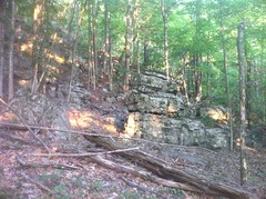
The entire hillside, in fact, appeared to be terraced with a long series of rock walls and flat ground between them. The rock was very geometric. It looked like the "lego cliffs" I'd seen up near Keown Falls a while back. I'd read once that the whole area is either currently owned, or was once owned by the Estelle Mining Company. It made me wonder if that hill had been quarried, top to bottom and I was just seeing what was left some decades later.
I arm-wrestled the trail for a couple of miles, then it turned even more downhill and became a full-on WWE Smackdown. It was by far, the most heavily deteriorated, marked trail that I've ever seen. For half a mile, I'm not sure I rode more than 50 feet at a time. In fact, "ride" would be a liberal description of what I did. Basically I alternated between yanking over one obstacle and then balancing while gravity gently pulled me over the next.
Looking down the trail...
Looking back up...
And these photos really don't capture it.
There were water bars scattered here and there, some suspended in mid air, only distinguishable from deadfall by the long, bent-over nails at either end. Others still sat on narrow pillars of soil, totally eaten out on either side. It was a rough trail for sure. I think it might be the roughest I've ever ridden.
As it flattened out, the character changed abruptly and the trail transitioned into a gravel road. I saw signs for the Estelle Mine Trail but it was already getting pretty late and I opted for pavement instead. The mine trail will have to wait.
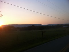
The sun had already dropped below Lookout Mountain.
I made it back to my car right at 8:30.
Wow. After crunching the numbers, it turns out that I climbed over 5000 feet, in 30 miles, 10 of which were dead flat road, so actually 5000 feet in 20 miles. I averaged under 5 miles an hour, including those road miles. That was a crawl.
I really wouldn't recommend anything I rode to anyone that isn't in the mood for anything other than pure exploration. West Brow might have been fun as a downhill, except for all of the downed trees. Ditto for Chamberlain. Actually the fire road leading to the Blue Hole was pretty good, so I might recommend that. If there had been fewer downed trees, long sections of the Pocket Trail might have been fun, but that last section was nuts.
The traffic up there appears to be mostly equestrian and the trails are mostly fall-line and steep enough to get chewed up. By hiking or mountain bike standards, they're highly deteriorated, but judging by the number of hoofprints I saw, they don't seem to be a problem for the equestrian community, they're just challenging trails. The environmental impact is hard for a layman like me to judge. With a few notable exceptions, the trails are mostly way up the mountain and the streams mostly cross them at right angles, and I imagine those streams are dry for half the year. I'd also bet that what water does flow out is impacted more by the farms and industry at the bottom than the trails. There might be some specific bug or fish or something that's suffering though, it's hard for me to say.
So, was it fun? Kind-of. I love exploring, I really got to test my rock crawling skills, I saw and did some interesting things, met some interesting people and didn't break myself off. I'm not so sure about fun, but I'll put it in the "worth having done" column. There are still a few trails up there that I haven't ridden yet too, so I imagine I'll be back. You never know, they might be awesome.


Blue hole is the resurgence of Ellison's cave water flow. It is a huge cave, about 12 miles in length, with the biggest vertical pit in the United States.(about 600 feet) there is also a 450 foot pit inside.
ReplyDelete