Travis emailed me last night:
Weekend Riding
Howdy gang!
Anyone up for a noonish start at one of the local runs Sat?
T
I'd kind of wanted to ride up in the mountains but today was the first day of bow season and I generally like to let the hunters have the forest for the first week of each season, so that sounded good to me.
I'd gotten busy though and by the time I'd emailed him back, he'd already made plans to go hiking with Michelle. Riding was off the menu but hiking sounded good too. Hunters rarely use the popular hiking trails. Hiking it was.
We met up at the Atlanta Bread off exit 14 and they gave me a ride up to the Raven Cliffs Falls lot. It occurred to me as we started moving... I could barely remember the last time I'd been hiking with other adults and no kids. I'm usually with my girls or by myself. The last few times that I could remember were in the middle of winter in crazy snow. Before that was when Kirk and I walked all over Mt. LeConte. I wondered if I could even keep up a reasonable speed.
I'm not sure if my speed was reasonable or not but nobody complained so I figured it was OK.
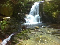
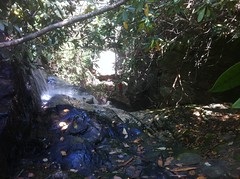
We cruised up the Raven Cliffs Falls trail which runs along Dodd Creek, home of every waterfall in the world. There are at least 4 minor cascades between the parking lot and Raven Cliffs.
Here's the second one.
And the third.
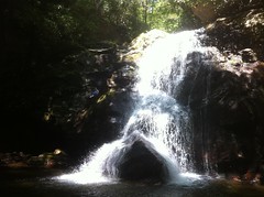
The last time we were up that way a girl told us there was a little trail leading down to that cascade but the only trail I could find required some skillful bouldering to descend. This time I noticed another trail that was a bit easier to get down. We took the bouldering route back up. Travis went directly up a small rock face. I looked hard for a line on that face but I wasn't confident in anything I saw. The holds he ended up using hadn't even occurred to me but he made it look easy. I ended up taking a different line with roots and other stuff to grab onto.
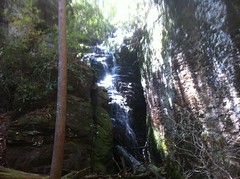
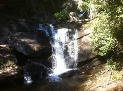
The rest of the climb was quick and easy and before long we reached the Raven Cliffs and its associated falls. There's this big split in the rock and the falls runs down through the split.
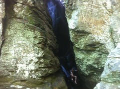
I've long wondered whether the split occurred first and then the falls just rerouted itself through the split or whether the falls just fell over the rock until it wore down through it, creating the split. The latter seemed less likely but you never know. The only way to find out was to climb up over the top of the cliffs and look at it from there but the last and only other time I was up there was a few years back with the girls and they were too little to make that climb.
Today though, I was kidless and Travis and I explored all over up there.
We climbed the roots...
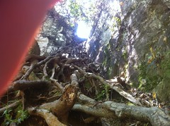
...and followed a rough trail around to the top of the falls and then back down the other side.
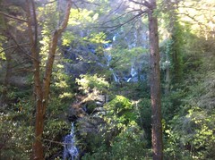
As it turns out the bit that you can see from below is about 10% of the falls. It looks like a very long time ago the water fell down one rock face, this one...
...and then, hemmed in by a huge block of rock, exited to the left side of the photo. But then that block of rock split and the creek rerouted itself through the split. Yay, mystery solved.
I climbed back up and checked out a few side trails at the top. There appeared to be an old roadbed leading further upstream. It ended abruptly at the falls so I imagine it was built down from somewhere higher up. It might tee into the AT, Whitly Gap Trail or Hwy 348. I've hiked those trails though and didn't notice any old roadbeds, but to be fair, when I hiked the AT there were several inches of snow on it and when I hiked Whitly a thunderstorm was coming in and I literally ran from the AT to the shelter.
While I was rummaging around up there, Travis climbed down. We could both see Michelle at the bottom but she couldn't see or hear us.
On the way back down I clambered out onto a big rock outcropping. I'd seen Travis out on it earlier, but it looked like the only way to get out to it was to cross over a 30 foot deep crevasse of doom on these two sketchy downed trees.
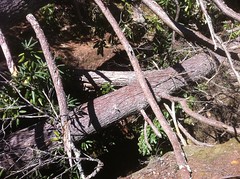
It was easy on the way out but getting back was a lot trickier. The worst part? It turned out there was a much easier way to get across, it was just obscured by the tangled branches of the downed trees.
We took a slightly different route back down that didn't require the scaling of roots.
The trail up there is getting wrecked pretty badly. I imagine the official trail ends at the lower falls, but there's nothing to indicate that, foot travel is legal anywhere in the National Forest and the upper falls is really interesting so people go up there all the time, official trail or not. I know people who would argue that access to the upper falls should be controlled by closing the entire trail and obliterating the parking area. It's really cool up there though and I'd like to see a sustainable, but less oppressive solution. Unfortunately I think that would have to involve stairs of some kind, either stone steps like on Blood Mountain or an actual wooden staircase. Being a Wilderness Area, I'm not sure what the rules are. I doubt it would be legal to build a wooden staircase. I'm not sure about building stone steps either, or for that matter putting up signs or any kind of construction that might close the trail. There are stone steps on Blood Mountain though, in the Wilderness, so I guess that is a potential solution but it would be a lot of work. I imagine something might be done someday though and since there's no way to know what it will be, I'm glad I was able to see the upper falls today.
At first, the trip back was tougher that I though it would be after the steep down-hiking from the upper falls. Eventually my legs recovered but it took about half the hike back.
It's only about 5 miles to the falls and back and we had plenty of day left. Dukes Creek was just up the road, so after a quick bathroom break, we headed up that way.
When I first got in the car back in Cumming, the first thing I said was something like: "My buddy Clark is going to be pissed when he finds out we're hiking up in his neck of the woods without calling him." I even thought about calling him, but I was the invited guest and it's not generally cool for the guest to then further invite as many additional people as the number that originally invited you.
As luck would have it, we ran into Clark and Suzy on the trail.
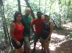
Clark immediately joked about being pissed that I didn't call him. Actually maybe he wasn't 100% joking. I run into people I know all the time riding, I guess it was only a matter of time before I started running into my hiking buddies as well. They'd already been down the falls and were heading back up. There were people trying to pass us in both directions so we didn't stop to chat for too long.
There are actually two cascades in the Dukes Creek Falls system. The secondary cascade is on Dukes Creek.
Ironically, the primary cascade is on Davis Creek.
And it's so weird, it just runs down the fall line of the mountain. Most creeks cut out some long valley and wherever they hit solid rock a falls occurs. Their feeder creeks tend to do the same and they tend to both cut the ground out at the same rate. That's certainly the case with Dodd and Dukes Creeks. Davis Creek does have a big long valley upstream but then it just drops precipitously into Dukes creek. There is a bit of a gorge there, on both sides. Maybe they were once at the same level but then something relatively sudden happened to Dukes, imparting it with additional flow, causing it to cut out the gorge and leave Davis behind. I wonder. I'm sure somebody knows.
Yay, we saw all the waterfalls in the world.
Next mission: food.
It's Octoberfest time and downtown Helen would be inaccessible by conventional means. The map shows obscure alternate routes into Helen but the only one we had at our disposal was Tower Road, accessible through Smithgall Woods, but I've never tried it before and I wasn't sure if it was viable. I'd seen this place called "Goats on the Roof" before, and it was right up the road, so we checked it out. It turns out it's not a restaurant. They have ice cream and fudge, but no food.
I'd swear a buddy of mine said he'd eaten there before, but I guess I was mistaken. Crazy.
Instead we headed to the Nacoochee Village Tavern and Pizzeria. Fortunately the Helen traffic didn't extend out that far and we scored some satisfying pizza.
All right! The GPS said 10 miles. That's a good day. I hope we get to do it again sometime.


I wasn't pissed, but it just goes to show you that you can't sneak into my back yard without me knowing about it! Great to see you and finally actually meet Travis and Michelle.
ReplyDelete